Tuesday, March 31, 2009

Walk 207 -- Keiss, via Duncansby Head, to John O'Groats

Ages: Colin was 66 years and 327 days. Rosemary was 64 years and 104 days.
Weather: Still windy, but warmer and drier.
Location: Keiss to John O’Groats.
Distance: 12½ miles.
Total distance: 1857 miles.
Terrain: Rough cliff top path. Tarmacked lane. Then very rough walking across a boggy moorland for a mile or so until we picked up the vestige of a rough path. Hard going!
Tide: In when we needed it to be out.
Rivers: No.166, Burn of Freswick. No. 167, Burn of Sannick.
Ferries: None.
Piers: None.
Kissing gates: No.175 as we approached Duncansby Head, and no. 176 as we left. Nos. 177, 178 & 179 as we approached John O’Groats.
Pubs: None.
‘Historic Scotland’ properties: None.
Ferris wheels: None.
Diversions: None.
How we got there and back: We were staying in a holiday cottage in Castletown. This morning we got up casually and drove to John O’Groats where we were pleased to find the car park was free — though the toilets weren’t! We caught a bus from the car park to Keiss, and alighted down in the village where the bus turned round. It was a short walk down to the harbour where we had parked the car yesterday.
At the end, we came to the car at John O’Groats. We were really elated that we had reached this milestone, and felt we were walking on air! We had our tea and caramel squares, then returned to our cottage in Castletown.

We were pleased that the weather seems to have improved immeasurably, lots of sunshine though still a wind. We left the harbour area in Keiss on a good path which lasted all of half a mile to Keiss Castle. 
On the way we passed a brick bunker with a turf roof, a bit more classy than the usual concrete pill boxes that were put up all round our coast during the War. Perhaps that’s why it has lasted so well, we were able to get inside and peep out at the castle ahead.
As we approached the castle we realised there was very little of it left. It hasn’t much of a history either, it was built in the early 17th century and abandoned after about a hundred years. Apparently it was never very big, and most of it has fallen into the sea. The way on was a bit confusing when we got there. We climbed round the gate in error, teetering on the edge of the cliff, then realised we shouldn’t have been there at all and had to climb back. Only after that did we see the ‘DANGER KEEP OUT’ notice on a rock. 


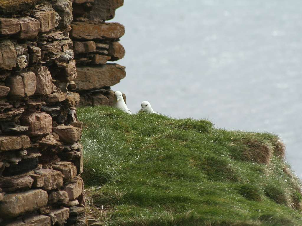
We thought the rocky ripple bed on the beach and the fulmars peeping round the ruined castle wall were more interesting than the castle itself.


After a good start, the path leading north from the castle got very rough. It kept between a fence and the cliff edge, and rounded every cleft right on the edge. This was a bit dodgy in some places! Several wet ditches had to be crossed, and occasionally we had to climb over a barbed wire fence. Perhaps this was the path that local man had in mind when we asked him on the bus the other day about the path between Noss Lighthouse and Ackergillshore. This path far better fits the description he gave us. However, we struggled on and got through.
The rocks we were passing were such rectangular blocks they looked as if they were man-made. A group of cormorants strutting on one of them just offshore looked as if they were on a stage!
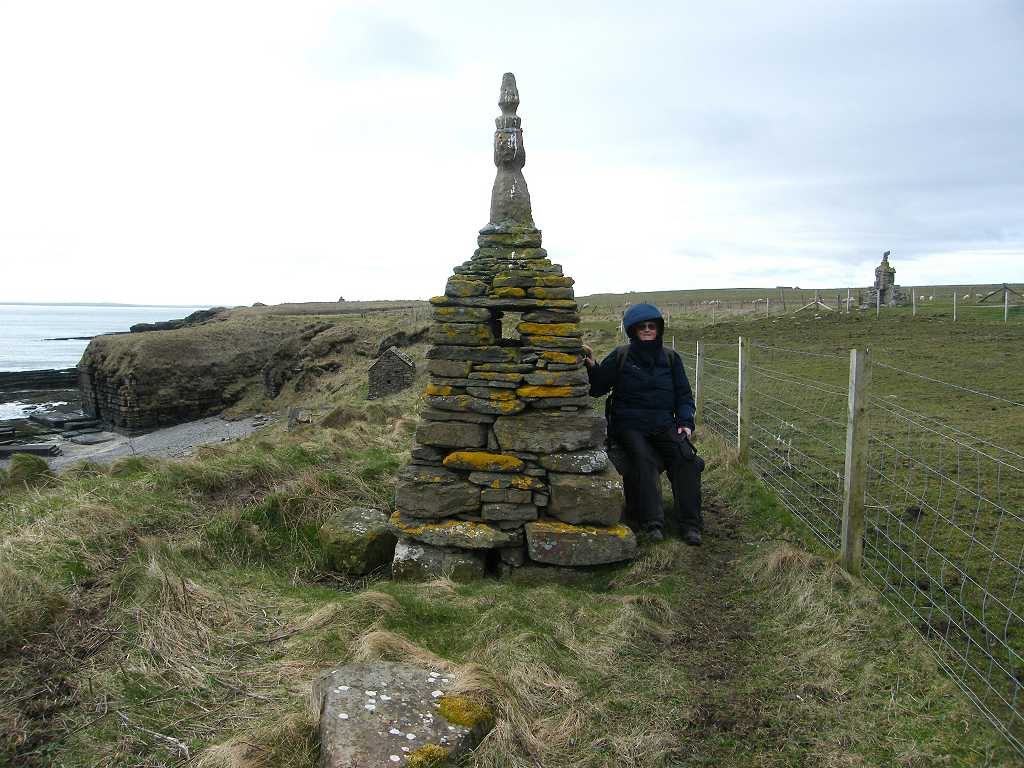
We sat on a bank out of the wind to eat our slices of quiche, and shortly after that we came to the remains of an iron age broch. This had been built thousands of years ago out of the blocky rocks from the cliff which are so regular they look like bricks. In front of them is a ghastly monument to the Victorian archaeologist who first excavated the site, and apparently part of the ancient structures were destroyed in the building of this tribute to the man who discovered them! 
The monument, also built with the local rock which looks like bricks, has little statues on top of it and gargoyles stuck to the sides — a monstrosity!


We had a quick look around the original iron-age settlement, then moved on. The path between there and the car park was good, then it deteriorated to its former sorry state. We passed a fancy cairn, another Victorian flight of fancy we guessed, and made slow progress further north. 
We were relieved that a stream which cut across our path had been bridged by the local farmer — a nice stone arch bridge made out of the blocky stone. 


We passed rock stacks, saw (and heard) eider ducks, razorbills and fulmars which would have all been lovely if the path hadn’t been so difficult. We crossed a wet ditch with difficulty (no little stone bridge there!) and had to negotiate no less than three barbed wire fences before we got to the scant ruins of Bucholly Castle. There we sat down out of the wind to eat our lunch.
I felt depressed. I was very tired and my legs ached. I thought I had bitten off more than I could chew, and didn’t feel I had the energy to complete the day’s Walk. (It was nearly two years later that these occasional bouts of weariness which overcame me were explained by an easily treatable medical condition.) I couldn’t work out how we could cut the Walk short because the car was at John O’Groats and there were no more buses today. I was worried about the moorland ahead which we had to cross with no path marked on the map, and I was totally fed up with barbed wire fences! As I ate my sandwiches I began to feel a little brighter — perhaps I was just hungry.
Colin tried to perk me up because he knows how much this Trek means to me now. When we first started it back in 1998 it was a bit of a laugh. We didn’t take it seriously, and never thought we would get anywhere near John O’Groats. And here we are just a few miles short of that famous landmark — we can’t give up now! He suggested we climb the hill behind us to cut out a big bit of land which sticks out into the sea. So we made up a new rule: If the coast is REALLY WIGGLY and we are fatigued to the point where we may not make it, we may take a short cut to miss out some of the wiggly bits.
We climbed the rounded hill — it wasn’t too difficult — and descended to a farm alongside a field with a bull, cow and calf in it. It would have been quicker to cut across this field, but decided that it wouldn’t be wise with such a combination of animals in it! It was a relief to find that all the gates we wished to pass through opened easily (of course we carefully closed and fastened them after us) but we couldn’t find our way out of the farm. We ended up in a courtyard where a man was getting something out of the boot of his car. We apologised for intruding, and asked him how we could get down to the nearby beach. He told us the ‘stile’ was a thin piece of polythene we should find on a barbed wire fence round the corner.
Well, the polythene was there, but was absolutely useless! We managed to squeeze ourselves round the end of the fence, but we were on the wrong side of the river. The tide was in, and it was far too deep to cross. So we returned to the farm and climbed up a bank to the farm bridge. We went through a gate, and crossed the river on a track nearly ankle deep in farm pooh! From there we clambered down to the sandy beach and washed our boots in the sea.
Bliss! We were on a sandy beach, albeit that it was short. But the sand was soft and it was hard to walk. 
Then Colin said, “There’s a seal ahead!” 
Sure enough, just swimming up and humphing itself out on the sand was a single seal. 
We think it was only a youngster, and it was quite curious about us as we slowly approached. 
It kept flopping in and out of the water, then looking round at us. 
We kept a respectful distance and it didn’t seem to be spooked by us at all. 
It was as curious about us as we were about him, or her. It was a magic moment! 
Delightful! Now we know why we are doing this Trek — it’s for times like this! Colin, especially, perked up enormously, but I was still worried about the moor ahead.
At the end of the beach we climbed up a track to a ‘yellow’ road and walked along it for about half a mile. It was straight, and that was easy walking. Then we turned north on a track up to the moor. We chose this track because it was marked on the map as going further into the moor than any other, but in hindsight perhaps we should have tried a more coastal route. We went through a farm where children were playing on a trampoline (it is the Scottish school holidays this week) and set out across the moor. Well, the track was rubbish! It didn’t go nearly as far as it was marked on the map, it was very uneven, boggy and altogether extremely difficult. The so-called track completely disappeared and my worst fears were realised. We felt we were at the end of the world!
We walked for a mile across this type of terrain which was tiring and time-consuming. The going was so uneven I fell over and cricked my back. Since I have an ongoing problem with that part of my anatomy, this was potentially serious. But what could I do out there in the middle of nowhere? I took some ibuprofen and we carried on. Thankfully it calmed down and was not as serious as we had thought at first. We were worried about a ‘river’ that had appeared alongside us to the left. We looked at the map, and couldn’t see a way out except to cross it, which was impossible because it was too wide and deep. Further on it disappeared into the heather — we were so relieved!
We got to a fence, and the going was very slightly easier alongside it. Was there a vestige of a path? It was difficult to tell. This was fine whilst the fence went along in the direction we wished to travel. But then we came to another fence which joined it at right-angles, completely blocking our way. We had no choice, we HAD to climb over it — barbed wire and all! We climbed a hill, using our compass, and there was another barbed wire fence across our route in the distance. Oh no! We really have had enough of this! But, hang on a minute! There are two posts quite close together which are bigger than the other posts, and there’s no wire between them! It’s a gateway without a gate! Beyond was definitely the vestige of a track which eventually turned into a good path.
We had cracked it! Suddenly we both experienced an enormous sense of elation, and all weariness disappeared. I felt a hundred times better immediately, and all my aches and pains seemed to melt away. We were on the coast path and it was a real path! We looked back, and a very faint trail disappeared along the top of the cliffs southwards. That was when we realised we should have perhaps taken a more coastal route from that ‘yellow’ road.
The scenery was spectacular! 
There were amazing rock stacks as we approached Duncansby Head, we have never seen anything like them before. 
The path was excellent by now, and we observed the fulmars on wide rocky ledges. 
Even the wind died a little making the walking more comfortable. 
We felt good!
We could the Orkney Islands offshore, so we knew we were really north! 
We could see Duncansby Head Lighthouse ahead but it seemed to be taking a long time to get there. So we sat on a concrete construction (Second World War vintage?) to eat our chocolate, hoping that would give us the extra ‘oomph’ to finish the Walk. As we approached the lighthouse we put our new rule into practice, and followed the path straight across two small promontories to the Duncansby Head car park. 
There was only one car there — a youngish couple got out for about five minutes, then got back in and drove off. They had missed all the best views, the amazing sea stacks are about half a mile to the south but it seems few can be bothered to walk that far. Now we know why we are doing this trek, even when the going gets tough!
So — we had reached the far north-western point of mainland Britain! Goodbye North Sea! Hello Arctic Ocean! We felt so HIGH! We were walking on air! We read an information board which told us there was a footpath along the coast all the way to Old Wick Castle. You could have fooled us! We had just tried to walk it, and in places the path simply doesn’t exist. Most of the rest of it we would class as ‘challenging’! It certainly isn’t way-marked in any part of its length.
We crossed a river on the road, then took a footpath across fields to John O’Groats which is a mere mile and a half away. By then the sun was low in the sky and shining directly into our eyes. 
So we tried to look north across the water to the Orkney Islands, but we had to keep looking back to see where we were going. It wasn’t a comfortable walk.
John O’Groats is a false place made out of nothing. It is simply the end of a road. The ‘tourist tat’ shops were all closed by the time we got there, and there were only a couple of other people around both engrossed in their mobile phones. We found a notice which established we were truly at John O’Groats, then each took a picture of the other which I merged at a later date on my computer.

That ended Walk no.207, we shall pick up Walk no.208 next time in the car park at John O’Groats. It was quarter to seven, so the Walk had taken eight hours thirty-five minutes. We had our tea and caramel squares, then returned to our cottage in Castletown.

WE HAVE WALKED ALL THE WAY FROM BOGNOR REGIS TO JOHN O’GROATS ALONG THE COAST, 1857 MILES !

Monday, March 30, 2009

Walk 206 -- Wick to Keiss

Ages: Colin was 66 years and 326 days. Rosemary was 64 years and 103 days.
Weather: Cold wind with far too many showers. But it did improve towards the end of the Walk.
Location: Wick to Keiss.
Distance: 13½ miles.
Total distance: 1844½ miles.
Terrain: Some pleasant tarmacked and gravel tracks. A lot of ‘sheep’ tracks across rough grass. About two miles of unpleasant road-walking. And a blissful firm sandy beach towards the end.
Tide: Coming in, then going out.
Rivers: No.164, Burn of Papigoe. No. 165, River of Wester.
Ferries: None.
Piers: None.
Kissing gates: No.174 at Ackergill Tower.
Pubs: None.
‘Historic Scotland’ properties: None.
Ferris wheels: None.
Diversions: None.
How we got there and back: We were staying in a holiday cottage in Castletown. This morning we didn’t have to get up quite so early as the journey to Keiss was shorter and the one and only bus was later. We parked at the harbour, where we chatted to a local lady who was quite indifferent to where we left the car for the day, she was more interested in our Trek so far. We walked up to the bus shelter near the main road, and caught the bus to Wick. There we walked back down to the bridge.
At the end, we came to the car. We had our tea and caramel squares, then returned to our cottage in Castletown.

The weather has been pretty awful the past few days, and we are hoping it will now improve. At least the temperature is slightly up today so we have rain instead of sleet and snow. But this wretched wind... I could never live in Caithness, the wind would drive me mad!
We started today’s Walk at the river bridge in Wick. We followed the road along the north side of the river to the harbour entrance, and found that a path continued all round North Head. We thought that very nice after our experiences on a supposed footpath on the last Walk!
We stopped and chatted to an old gent about a war memorial we came upon. This was erected in 1909, a hundred years ago and five years before the First World War broke out. It commemorates the men who lost their lives in previous campaigns which were important to the British Empire, as it was then. It lists Trafalgar, the Nile, the Baltic and other places I have never heard of. We thought it very poignant that one of the countries mentioned is Afghanistan, where British soldiers are fighting and losing their lives on this very day. Haven’t we learned anything in the last hundred years?
There are no individual names on the memorial, apparently they are inside. The inscription reads: To perpetuate the patriotism of those natives of Caithness who served their country on land and sea. Many of their names, rescued from forgetfulness, are preserved for posterity in this memorial tower. Their names are here: their deeds are in the histories of the world. 1909
We were surprised to pass a warning notice about ‘dangerous cliffs’, we thought that in Scotland people were responsible for their own actions and so didn’t need such patronising notices which festoon the cliffs around England. We passed some interesting rocks and a cartwheel outside someone’s house before we came out in the hamlet of Papigoe. There we walked north on the lane.
It kept raining which was most unpleasant, and we wondered if we would have a repeat of the dreadful weather we experienced on the last Walk. There was a footpath across the fields to Staxigoe, not marked on the map but we thought we’d give it a go. It was a bit boggy, but didn’t cause much of a problem. It was still raining, so we sat in a barn to eat our pies — at least, Colin had a pie but I had a slice of quiche. It sort of stopped raining by the time we had finished, well almost.
Staxigoe is hardly bigger than Papigoe, but it has a small harbour. A notice told us the history of the place at great length. The settlement started off as a “Clearance” village where farming communities, who had been turned out of their homes in the glens, came to live. They survived by fishing for herring — work they knew nothing about so many of them lost their lives at sea. Grain used to be stored in the village to await shipment, and there were slate quarries nearby which also provided employment. But herring fishing became the most important industry in Staxigoe, it was the first place to salt (‘cure’) the herring before export so that the fish lasted longer. As the boats got bigger, a new harbour was needed and Wick was chosen as the place where this was to be built. Staxigoe lost its importance, and even more so about fifty years ago when over-fishing and foreign competition caused the herring market to collapse.
We continued up a farm track and came across a notice saying “Walkers Welcome”! It was like a breath of fresh air to read that, at last we felt really comfortable walking across farmland where we never knowingly do any harm. Thank you the farmer of Noss Farm!
Further on there was another notice stuck to a fence, it said: “Access provided through Farm Land & Nature Reserve. No Disturbance please. No loose Dogs.” Fair enough! I’m sure 99% of walkers would work together with landowners all over the country for their mutual benefit (eg. on our travels we have occasionally returned a lost lamb to its mother, rolled a sheep over that was struggling on its back or alerted a farmer to a problem that was too big for us to deal with) — I wish someone would explain this to the farmers in England and Wales.
We went through the farmyard, then there was a sort-of path all the way to the lighthouse which was quite pleasant to walk. We strongly suspected it was a sheep track because there was oodles of pooh about, but it did for us — if only it didn’t keep raining. There were occasional clefts in the clifftop we had to walk through, but none were very deep and all the streams were crossable.
We passed some interesting rocks before we reached Noss Lighthouse on the promontory. A notice on the gate of the lighthouse complex read: Noss Head Estates. Clan Sinclair Study Centre. Clan Sinclair Library. Prince Henry Sinclair Preceptory. Please telephone for an appointment. and it gave a telephone number. What an out-of-the-way place for a study centre! How many people can get all the way up here to the far north of Scotland to use it? Crikey, we’re almost at John O’Groats! I suppose it’s nice and quiet for all that studying... except for the constant wind which would drive me to distraction.
The coast turned west. We couldn’t get round the sea end of the lighthouse, so we went through a gate to a road. Then we squeezed round the end of a fence on to another sort-of path which took us westwards along the clifftop.
After passing some more interesting rocks we came to Castle Sinclair Girnigoe which is an absolute ruin. So we were surprised to find a plaque unveiled by Prince Charles in 2005 to mark the beginning of its restoration. Why? I would have thought a castle which was that far gone would have been a lost cause! I, for one, have far better things to spend my money on, and far more worthy charities to donate to.
A noticeboard gave a potted history — it is the usual story. The castle was built in the 14th century and radically altered in subsequent years to illustrate the wealth of the owner. It sent people out to battle, withstood many sieges and was abandoned in 1690 after being badly damaged by cannon fire. At the moment it is closed to visitors, and there was scaffolding on one end. We sat in the lee of its wall to eat our sarnies out of the wind. Then we continued along the clifftop.
When we were on the bus earlier in the day, we had asked a local man if there was a footpath along the coast between Noss Lighthouse and Ackergillshore. (Once again, none is marked on the map.) He replied that he thought it was possible to walk along there, but it would be “dangerous” and we’d have to climb over lots of fences. So we had been quite gloomy at the prospect of not being able to get through. It was very important to us that we did, otherwise we would have to return to Wick and continue along the dreaded A99 all round Wick Airport, a detour of miles! Therefore we were delighted to find that there was quite a good path which led us easily all the way to Ackergillshore between a wall and the clifftop without having to climb a single fence. So much for listening to the locals! We had successfully skirted the airport which wasn’t exactly busy. Just one propeller plane had landed in all the time we took to do today’s Walk — nothing took off.


At Ackergillshore we passed a small jetty, a storehouse with a turf roof, and then went round the corner to find the path stopped.

We thought at first there was no way on, but we took the road inland for a few yards and found the route back to the shore via a children’s playground and a funny revolving gate. (It was raining again, and we got a smudge of wet on the camera lens when photographing that.)
There was a structure over a wall which looked, at first, as if it was a whalebone arch. But we think it was made of wood — not sure what it was. The track led to an imposing building called Ackergill Tower. The path led through on the sea side of this establishment which had a high wall with a very fancy gate in it. A notice told us it was PRIVATE.
Just beyond the tower, steps led us over a wall for about fifty yards, then led us back. We had no idea why this was. Another thing we couldn’t make out was an item marked “Decoy” on the map. It looked like an artificial shallow pond to us, but we had no idea why it was there so near the sea. It still kept raining, and did so quite heavily at that point.
We were approaching a three-mile long sandy beach, but there was a problem. About half way along it a river came out, and there was no bridge. If the tide had been out we might have risked walking along the sands because rivers often braid as they run across the beach, and are usually at their most shallow just where they run into the sea. But the tide was right in. If we got to the river and couldn’t cross it, we would have to return a mile and a half to where we were standing in order to divert to the road — three miles wasted walking. We weren’t prepared to risk that, we were too tired.
So we turned away from that beautiful sand and took a ‘white’ road which led us in a straight line to the A99. Just before we emerged on to the dreaded highway, we stopped by a fence to eat our chocolate. There was nowhere to sit down because it was so wet everywhere, so we leant on the fence. There was a farmhouse nearby, and the farmer and his teenage son came out to ask us what we were doing — we must have looked suspicious! They relaxed when they realised we were just a pair of crazy walkers, and I gave them one of my blog cards. They expressed surprise that it is possible to walk along the coast all the way from the lighthouse, obviously they had never done it! Then they told us we would “probably have been all right” going along the beach and crossing the river. Since they didn’t know about the footpath we had just walked, I didn’t really trust them to know whether the river was crossable!
We put on our bright yellow visible vests and embarked on a couple of miles of hellish road-walking until we had crossed the river on a bridge. It looked quite a big river there, so I think we made the right decision. Colin’s knee began to trouble him, and he took some ibuprofen. We removed our visible vests, relieved to be off the road.
After crossing the river we turned into what looked like a ‘works’ entrance as we were keen to get back to the beach as quickly as possible. We weren’t sure what the ‘works’ was all about, but thought they might be involved with making oil pipelines.
We turned off their road at the first bend, crossed a muddy field, made our way through the dunes where a lot of sand seemed to have been removed, and came out on to the firm sandy beach.
Bliss! We then had at least a mile of walking in our favourite environment — dunes to the left of us and pounding surf to the right. Even the weather improved — the wind died, the temperature rose and it stopped raining though it remained very grey.
And as for our mood — we were walking on clouds! I felt a lot better about the whole project after that walk on the beach. This is what it is all about, not interminable road-walking! Our ‘peace’ was only disturbed by a noisy helicopter flying overhead.
It was over a mile before the sand ran out, and the beach got too rocky to walk comfortably. By then we only had half a mile to go, and there was a very walkable track along the top of the beach the rest of the way into Keiss.
We passed a ruined cottage, then came to the village proper. We took an uneven path down the grass bank to the picturesque harbour. Our car was parked nearby.

That ended Walk no.206, we shall pick up Walk no.207 next time at the harbour in Keiss. It was half past six, so the Walk had taken eight hours. We had our tea and caramel squares, then returned to our cottage in Castletown.