Ages: Colin was 73 years and 68 days. Rosemary was 70 years and 210 days.
Weather: Sunny with a cloudless sky. A cool breeze — it was perfect for walking!
Location: Trefasser to Abercastle.
Distance: 7 miles.
Total
distance: 3859 miles.
Terrain:
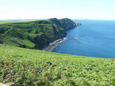
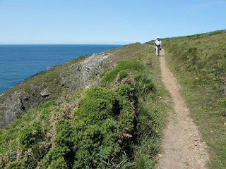
Undulating cliff paths. There
were some steep climbs but not too many — mostly it was pretty gentle.
Tide: Low
water 2pm approx.
Rivers: None.
Ferries: None.
Piers: None.
Kissing gates: Nos.895 (which we missed because we took a
short cut), 896 & 897.
Pubs: None.
‘Cadw’ properties: None.
Ferris wheels: None.
Diversions: None.
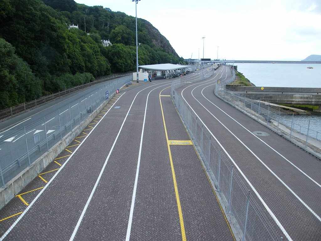
How we got there and back: We were staying in our caravan in Letterston. This morning we drove to Abercastle and parked by the bus stop. We caught a bus to Trefasser Cross and walked up to the viewpoint.
At the end we came to the car. We moved the car to the waterfront of this idyllic little place, had our tea, then returned to the caravan. The next day we towed the caravan home.
My left knee has been hell ever since the last Walk, and was especially so this morning. We nearly didn’t come, but I was determined not to give up. I had replanned the next few Walks so we can do them in much shorter ‘bites’.
 We sat on seats at the viewpoint at Trefasser
before we started today’s Walk, and ate our pasties. We enjoyed a wonderful view along the next
part of the coast to a headland about a mile away. Some other people joined us before we left
and we exchanged pleasantries. In fact
we met quite a few people walking in both directions on today’s section of the
Wales Coast Path — it makes a change to being on our own. After two days of solid rain, we think everyone
was just glad to get out. The weather
was perfect today.
We sat on seats at the viewpoint at Trefasser
before we started today’s Walk, and ate our pasties. We enjoyed a wonderful view along the next
part of the coast to a headland about a mile away. Some other people joined us before we left
and we exchanged pleasantries. In fact
we met quite a few people walking in both directions on today’s section of the
Wales Coast Path — it makes a change to being on our own. After two days of solid rain, we think everyone
was just glad to get out. The weather
was perfect today.

 We passed a memorial to Dewi Emrys
1879 – 1952, but the writing on the stone was in Welsh so we didn’t know what
he did. (I looked him up on the internet later and found out he was a Welsh
poet of note.) We walked for about a
mile along the top of a ridge with amazing views to either side. It was a steep climb towards the end, quite
rocky and my knee was very painful despite dosing my self up with far too many
painkillers.
We passed a memorial to Dewi Emrys
1879 – 1952, but the writing on the stone was in Welsh so we didn’t know what
he did. (I looked him up on the internet later and found out he was a Welsh
poet of note.) We walked for about a
mile along the top of a ridge with amazing views to either side. It was a steep climb towards the end, quite
rocky and my knee was very painful despite dosing my self up with far too many
painkillers.
 I climbed very slowly,
being careful never to have my left leg in the lead as I climbed each
step. It was worth the struggle because
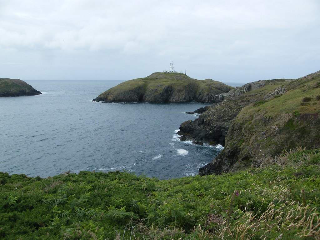
at the top it was like being on the summit of a mountain. Visibility was excellent. Ahead we could see as far as St David’s
Head. Behind we could just see Strumble
Head lighthouse flashing. We were at the
highest point of the day, and it made us feel good to be alive.
I climbed very slowly,
being careful never to have my left leg in the lead as I climbed each
step. It was worth the struggle because
at the top it was like being on the summit of a mountain. Visibility was excellent. Ahead we could see as far as St David’s
Head. Behind we could just see Strumble
Head lighthouse flashing. We were at the
highest point of the day, and it made us feel good to be alive.

 The path down was very steep and quite
rocky. I found it extremely
difficult. I took it very slowly — my
poles were invaluable, and so was Colin who helped me all the way. But once we got down to a certain level the
path evened out and was quite gentle for the next stretch. I felt quite fatigued after all that
tenseness and effort, so we sat on a bank by the side of the path to eat our
sarnies. Colin very nearly sat on an
ants’ nest but he saw it just in time!
The path down was very steep and quite
rocky. I found it extremely
difficult. I took it very slowly — my
poles were invaluable, and so was Colin who helped me all the way. But once we got down to a certain level the
path evened out and was quite gentle for the next stretch. I felt quite fatigued after all that
tenseness and effort, so we sat on a bank by the side of the path to eat our
sarnies. Colin very nearly sat on an
ants’ nest but he saw it just in time!

 We carried on through a bit of a
gully, but it wasn’t too bad. Coming up
out of it the main path took another deep dip, but we could see that the
original path didn’t do this. So we
stepped over a fence (not barbed wire) and stepped over a ditch to get on to
it. It was a little overgrown but not
too much — we’ve been on far worse paths in Scotland! Doing this saved us a big chunk of downhill
and up.
We carried on through a bit of a
gully, but it wasn’t too bad. Coming up
out of it the main path took another deep dip, but we could see that the
original path didn’t do this. So we
stepped over a fence (not barbed wire) and stepped over a ditch to get on to
it. It was a little overgrown but not
too much — we’ve been on far worse paths in Scotland! Doing this saved us a big chunk of downhill
and up.

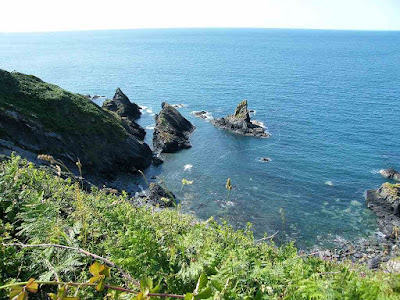
 The next section was a good path over
cliffs. Colin kept stopping all along to
photograph bugs, but that let me make progress at my own pace and have lots of
rests. We went down to a beach where we
had to walk across shingle — ahah-ah-ahgr!! But the stones were large and flat and didn’t
move much, so I took it slowly and coped.
It wasn’t far.
The next section was a good path over
cliffs. Colin kept stopping all along to
photograph bugs, but that let me make progress at my own pace and have lots of
rests. We went down to a beach where we
had to walk across shingle — ahah-ah-ahgr!! But the stones were large and flat and didn’t
move much, so I took it slowly and coped.
It wasn’t far.
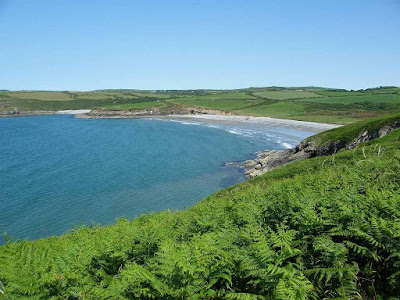
 We climbed up over some more low
cliffs, then down on to another beach. There
were quite a few people sunbathing on this one.
I was exhausted, it had all been too much effort with my bad knee. We sat on a bank and ate some chocolate —
that helped to increase my energy levels.
This beach also had flat stones so I took it very carefully and it
wasn’t too bad.
We climbed up over some more low
cliffs, then down on to another beach. There
were quite a few people sunbathing on this one.
I was exhausted, it had all been too much effort with my bad knee. We sat on a bank and ate some chocolate —
that helped to increase my energy levels.
This beach also had flat stones so I took it very carefully and it
wasn’t too bad.

It was a steep path up on to the cliffs again which was deep in ferns. It was wet underfoot, we reckoned that water had poured down there during the past two days of solid rain. There was a tunnel under the main path at the top which seemed to have a stream running through it. The path was fairly even and almost flat now, that helped a lot. I began to feel a little better then, not quite so exhausted.

 Colin wanted an apple stop, he said he
was “apple-starved”! But we couldn’t
find anywhere to sit down. We came to
the final gully which was quite deep. I
took a long time getting down to the footbridge where one of the boards was
broken. But it was only a shallow ditch
underneath so it didn’t really matter.
We sat on a bank the other side and ate our apples — Colin was
satisfied.
Colin wanted an apple stop, he said he
was “apple-starved”! But we couldn’t
find anywhere to sit down. We came to
the final gully which was quite deep. I
took a long time getting down to the footbridge where one of the boards was
broken. But it was only a shallow ditch
underneath so it didn’t really matter.
We sat on a bank the other side and ate our apples — Colin was
satisfied.
 We climbed up again, and then
the last mile of today’s Walk was fairly flat.
I actually felt quite good, and my knee was behaving for a change. I was glad I had come and hadn’t cried off.
We climbed up again, and then
the last mile of today’s Walk was fairly flat.
I actually felt quite good, and my knee was behaving for a change. I was glad I had come and hadn’t cried off.
 Our destination, Abercastle, is in a
tiny inlet which is completely hidden from the coast path until the last
minute, it’s quite incredible. The beach
suddenly revealed itself as we walked along.
Our destination, Abercastle, is in a
tiny inlet which is completely hidden from the coast path until the last
minute, it’s quite incredible. The beach
suddenly revealed itself as we walked along.
 We came to a nice safe beach with children playing in canoes. There were boats a little further out. We descended to the beach behind which our
car was parked. It is a delightful
place, tiny.
We came to a nice safe beach with children playing in canoes. There were boats a little further out. We descended to the beach behind which our
car was parked. It is a delightful
place, tiny.
 That ended Walk no.374, we shall pick
up Walk no.375 next time on Abercastle
Beach. It was twenty past five, so the Walk had
taken us six and a half hours. As I sat
on the beach sipping my tea I realised that I simply cannot continue with this
Trek until I have had surgery to replace my left knee at least. But the steel pin in my thigh put there after
a skiing accident in 1999 is going to be a problem and I cannot see my way
forward. I shed a silent tear before we
left this idyllic place, and I wondered if I would ever come here again. We returned to the caravan, and the
next day we towed the caravan home to Malvern.
That ended Walk no.374, we shall pick
up Walk no.375 next time on Abercastle
Beach. It was twenty past five, so the Walk had
taken us six and a half hours. As I sat
on the beach sipping my tea I realised that I simply cannot continue with this
Trek until I have had surgery to replace my left knee at least. But the steel pin in my thigh put there after
a skiing accident in 1999 is going to be a problem and I cannot see my way
forward. I shed a silent tear before we
left this idyllic place, and I wondered if I would ever come here again. We returned to the caravan, and the
next day we towed the caravan home to Malvern.
Pubs: None.
‘Cadw’ properties: None.
Ferris wheels: None.
Diversions: None.
How we got there and back: We were staying in our caravan in Letterston. This morning we drove to Abercastle and parked by the bus stop. We caught a bus to Trefasser Cross and walked up to the viewpoint.
At the end we came to the car. We moved the car to the waterfront of this idyllic little place, had our tea, then returned to the caravan. The next day we towed the caravan home.
My left knee has been hell ever since the last Walk, and was especially so this morning. We nearly didn’t come, but I was determined not to give up. I had replanned the next few Walks so we can do them in much shorter ‘bites’.


It was a steep path up on to the cliffs again which was deep in ferns. It was wet underfoot, we reckoned that water had poured down there during the past two days of solid rain. There was a tunnel under the main path at the top which seemed to have a stream running through it. The path was fairly even and almost flat now, that helped a lot. I began to feel a little better then, not quite so exhausted.