Weather: Overcast and cool at first, later it turned
very hot and sunny. Visibility was poor
all day.
Location: Barmouth, via Fairbourne, to Tonfanau.
Distance: 9 miles.
Total distance: 3726 miles.
Terrain: Mostly roads. Undulating and boring!
Tide: Out.
Rivers: No.439, Mawddach Estuary.
Ferries: No.25 across the Mawddach Estuary mouth to Fairbourne. Fare: £2 each.
Piers: None.
Kissing gates: None.
Pubs: None.
‘Cadw’ properties: None.
Ferris wheels: None.
Diversions: None.
How we got there and back: We were staying in our caravan in Snowdonia. This morning we drove from there to Tonfanau where we parked opposite the station. We caught a train to Barmouth, then we walked to the ferry steps.
At the end we finished the Walk at the car. I had noticed lots of luscious blackberries in the hedgerow nearby, so we picked a bowlful while we had our tea and biscuits. We drove back to our caravan and immediately took the awning down, packing it away in the car.
The next day we towed our caravan back home to Malvern.


We started today’s Walk by catching the ferry from Barmouth to Fairbourne. This was because ferries are allowed in our ‘rules’, but it meant that we didn’t walk across Barmouth Bridge next to the railway.
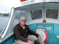
The ferryman was very chatty, and we were the only passengers for that crossing. He told us how a concrete bar was built across from Barmouth to an island in the estuary allowing the dunes to grow. I thought they weren’t there back in the 1960s — I holidayed in Barmouth in 1962 and in 1966.
 We had lovely views of Barmouth Bridge,
but the mountains were misty because visibility was poor due to three weeks of
high pressure. The weather was cooler
and overcast today, so perhaps this period of fine settled weather is coming to
an end. Good job we are going home
tomorrow!
We had lovely views of Barmouth Bridge,
but the mountains were misty because visibility was poor due to three weeks of
high pressure. The weather was cooler
and overcast today, so perhaps this period of fine settled weather is coming to
an end. Good job we are going home
tomorrow!

 We landed on a sand spit on the Fairbourne side of the estuary, and we
walked through the dunes to the Fairbourne Railway Terminus. There were no trains today though the
ferryman had been hopeful, in fact there didn’t seem to be anyone around at
all. Not that we wanted to ride on the
train, we just wanted to take pictures of the engines.
We landed on a sand spit on the Fairbourne side of the estuary, and we
walked through the dunes to the Fairbourne Railway Terminus. There were no trains today though the
ferryman had been hopeful, in fact there didn’t seem to be anyone around at
all. Not that we wanted to ride on the
train, we just wanted to take pictures of the engines.
 The line goes round in a loop, but the circle
is obviously no longer used because it was covered in sand. We followed it round and came to a concrete
‘tunnel’. We were not allowed to go
through it so we walked over the top. We
sat on a bench at ‘Estuary Station’ to eat our pies.
The line goes round in a loop, but the circle
is obviously no longer used because it was covered in sand. We followed it round and came to a concrete
‘tunnel’. We were not allowed to go
through it so we walked over the top. We
sat on a bench at ‘Estuary Station’ to eat our pies.
 We watched a real train trundle across Barmouth Bridge
to Morfa Mawddach Station, near the tiny B&B where we spent our honeymoon
in 1966. In those days, the waiting room
on Morfa Mawddach Station was a lively pub!
It was a very jolly place on a summer’s evening. Now there aren’t even any buildings on the
station.
We watched a real train trundle across Barmouth Bridge
to Morfa Mawddach Station, near the tiny B&B where we spent our honeymoon
in 1966. In those days, the waiting room
on Morfa Mawddach Station was a lively pub!
It was a very jolly place on a summer’s evening. Now there aren’t even any buildings on the
station.

 We looked across to Cader Idris
and laughed about the ‘wrong mountain’ story.
(On our honeymoon we spent all of
one day climbing to the top of Wales’s
second highest mountain in sandals! When we sat down at the top, exhausted and
very hot, Colin looked at the map and announced, “This is not the top of Cader
Idris, this is the wrong mountain!” It’s a wonder we’re still married after 48
years!)
We looked across to Cader Idris
and laughed about the ‘wrong mountain’ story.
(On our honeymoon we spent all of
one day climbing to the top of Wales’s
second highest mountain in sandals! When we sat down at the top, exhausted and
very hot, Colin looked at the map and announced, “This is not the top of Cader
Idris, this is the wrong mountain!” It’s a wonder we’re still married after 48
years!)
 We walked along the sea wall all the way through Fairbourne, passing a
number of second World War anti-tank posts on the way.
We walked along the sea wall all the way through Fairbourne, passing a
number of second World War anti-tank posts on the way.
 This coastline must have been quite
vulnerable, but it was well protected. There
were a few people about, but no trains.
We had to leave the beach there.
We went through a tall bridge under the railway and climbed up to the
road. There we donned our bright yellow
waistcoats.
This coastline must have been quite
vulnerable, but it was well protected. There
were a few people about, but no trains.
We had to leave the beach there.
We went through a tall bridge under the railway and climbed up to the
road. There we donned our bright yellow
waistcoats.
We don’t know where the Wales Coast Path went from thereon, but wherever it was it involved climbing mountains. We were not willing to do that, so we stuck to the road despite the lack of footpaths and speeding traffic.
 Even
so, it was quite a stiff climb, and we were soon way above the railway which
snakes along the side of the cliff. Fortunately
there didn’t seem to be that much traffic.
There was nowhere to go when it did come — once it was a bus, and with
traffic coming the other way it just had to wait.
Even
so, it was quite a stiff climb, and we were soon way above the railway which
snakes along the side of the cliff. Fortunately
there didn’t seem to be that much traffic.
There was nowhere to go when it did come — once it was a bus, and with
traffic coming the other way it just had to wait.
 We walked for miles along that road.
It was very scenic with good views over the railway and out to sea. We came to a bridge over a stream where the
RSJ had a dip in it! A modern bridge had
long-since been built, and we were able to have a few yards of relief by going
over the old one. There was a layby
nearby, so we sat on a wall there and ate our sarnies.
We walked for miles along that road.
It was very scenic with good views over the railway and out to sea. We came to a bridge over a stream where the
RSJ had a dip in it! A modern bridge had
long-since been built, and we were able to have a few yards of relief by going
over the old one. There was a layby
nearby, so we sat on a wall there and ate our sarnies.
 We walked down into Llwyngwril where we diverted slightly to use the
loo. We had read about an interesting
medieval church in our Welsh Churches book, and we found a notice which told us
that this particular church was just a mile south of Llwyngwril. In actual fact it was a good two! We plodded on as the sun came out and it got
very hot.
We walked down into Llwyngwril where we diverted slightly to use the
loo. We had read about an interesting
medieval church in our Welsh Churches book, and we found a notice which told us
that this particular church was just a mile south of Llwyngwril. In actual fact it was a good two! We plodded on as the sun came out and it got
very hot.
 Even the sheep were feeling
the heat because we passed a field where they were lined up in the shade of a hedge. Every rise and bend we came to we
hoped that the church would be just round the corner. But it wasn’t.
Even the sheep were feeling
the heat because we passed a field where they were lined up in the shade of a hedge. Every rise and bend we came to we
hoped that the church would be just round the corner. But it wasn’t.
 Then suddenly it was! But the
church was down there, and we were up
here — going down there was a dead
end, and we would have to climb back up to get out again. We decided to drive down there on our way
back and look at the church then, but Colin noticed a sign saying there was no
parking or turning points down there. So
we decided to give it a miss, but changed our minds and walked down —
excruciating on my knees which hadn’t been too bad up until then.
Then suddenly it was! But the
church was down there, and we were up
here — going down there was a dead
end, and we would have to climb back up to get out again. We decided to drive down there on our way
back and look at the church then, but Colin noticed a sign saying there was no
parking or turning points down there. So
we decided to give it a miss, but changed our minds and walked down —
excruciating on my knees which hadn’t been too bad up until then.
 We sheltered in the shade of the lych gate to rest for a while. The church was very interesting and well
worth looking at, but too many nanny-type notices about for our liking. One said, “No Flash Photography” inside the
church. So we didn’t — we were very
good!
We sheltered in the shade of the lych gate to rest for a while. The church was very interesting and well
worth looking at, but too many nanny-type notices about for our liking. One said, “No Flash Photography” inside the
church. So we didn’t — we were very
good!
 There were some ancient paintings
of skeletons and things on one wall, and we were amazed how well our pictures
came out without flash considering they were practically in the dark. The simple bench pews dated from the 1820s,
and still bore the names of the people who were allowed to sit on them.
There were some ancient paintings
of skeletons and things on one wall, and we were amazed how well our pictures
came out without flash considering they were practically in the dark. The simple bench pews dated from the 1820s,
and still bore the names of the people who were allowed to sit on them.
 (The servants and farm workers had to sit in
the unnamed pews at the back, of course — another
age!)
(The servants and farm workers had to sit in
the unnamed pews at the back, of course — another
age!)
We sat in the shade of the lych gate again to eat our apples before climbing back up to the road. It was steep, but not as hard on the knees as it had been coming down. It’s steeply downhill that is the killer! We stomped along until the road turned sharply inland. After about five hundred yards, the Wales Coast Path turned off through a farm and into fields. We thankfully removed our bright yellow waistcoats.
 Several of the sheep we passed were limping, and there was no one about
to see to them — shame on the farmers! We
sat on a rocky slope in one field to eat our chocolate, it was a lovely quiet
rural scene. In the next field Colin
disputed the direction. He said we
should follow the contours around, but I said we should go straight down until
we hit a road. I was right! (Ha!
Ha!)
Several of the sheep we passed were limping, and there was no one about
to see to them — shame on the farmers! We
sat on a rocky slope in one field to eat our chocolate, it was a lovely quiet
rural scene. In the next field Colin
disputed the direction. He said we
should follow the contours around, but I said we should go straight down until
we hit a road. I was right! (Ha!
Ha!)
The road was a quiet one, no need for yellow waistcoats. We had just over a mile to go. I sent Colin on to make the tea — he’s never good company when he’s hot and bothered, and has been proved wrong!
 I passed a
couple of models of walkers made out of logs — they looked just like Colin and
myself!
I passed a
couple of models of walkers made out of logs — they looked just like Colin and
myself!
 Then I passed the ruins of a
redundant army camp. A plaque at the
entrance gate said that it was used between 1959 and 1966 for the training of
‘Junior Leaders’ aged between 15 and 18.
(They came as boys and left two
years later as men) This camp was
the reason for Tonfanau Station which is opposite the gate, a request stop
which we used this morning to get ourselves into Barmouth. Our car was parked by the gate.
Then I passed the ruins of a
redundant army camp. A plaque at the
entrance gate said that it was used between 1959 and 1966 for the training of
‘Junior Leaders’ aged between 15 and 18.
(They came as boys and left two
years later as men) This camp was
the reason for Tonfanau Station which is opposite the gate, a request stop
which we used this morning to get ourselves into Barmouth. Our car was parked by the gate.

That ended Walk no.361, we shall pick up Walk no.362 next time at Tonfanau Station. It was twenty-five to five, so the Walk had taken us six hours ten minutes. I had noticed lots of luscious blackberries in the hedgerow nearby, so we picked a bowlful while we had our tea and biscuits. We drove back to our caravan and immediately took the awning down, packing it away in the car. My dodgy knee had 'behaved' quite well throughout the Walk, but later in the evening when I was resting it was mega-painful.
The next day we towed our caravan back home to Malvern.
Location: Barmouth, via Fairbourne, to Tonfanau.
Distance: 9 miles.
Total distance: 3726 miles.
Terrain: Mostly roads. Undulating and boring!
Tide: Out.
Rivers: No.439, Mawddach Estuary.
Ferries: No.25 across the Mawddach Estuary mouth to Fairbourne. Fare: £2 each.
Piers: None.
Kissing gates: None.
Pubs: None.
‘Cadw’ properties: None.
Ferris wheels: None.
Diversions: None.
How we got there and back: We were staying in our caravan in Snowdonia. This morning we drove from there to Tonfanau where we parked opposite the station. We caught a train to Barmouth, then we walked to the ferry steps.
At the end we finished the Walk at the car. I had noticed lots of luscious blackberries in the hedgerow nearby, so we picked a bowlful while we had our tea and biscuits. We drove back to our caravan and immediately took the awning down, packing it away in the car.
The next day we towed our caravan back home to Malvern.


We started today’s Walk by catching the ferry from Barmouth to Fairbourne. This was because ferries are allowed in our ‘rules’, but it meant that we didn’t walk across Barmouth Bridge next to the railway.

The ferryman was very chatty, and we were the only passengers for that crossing. He told us how a concrete bar was built across from Barmouth to an island in the estuary allowing the dunes to grow. I thought they weren’t there back in the 1960s — I holidayed in Barmouth in 1962 and in 1966.


We don’t know where the Wales Coast Path went from thereon, but wherever it was it involved climbing mountains. We were not willing to do that, so we stuck to the road despite the lack of footpaths and speeding traffic.


We sat in the shade of the lych gate again to eat our apples before climbing back up to the road. It was steep, but not as hard on the knees as it had been coming down. It’s steeply downhill that is the killer! We stomped along until the road turned sharply inland. After about five hundred yards, the Wales Coast Path turned off through a farm and into fields. We thankfully removed our bright yellow waistcoats.
The road was a quiet one, no need for yellow waistcoats. We had just over a mile to go. I sent Colin on to make the tea — he’s never good company when he’s hot and bothered, and has been proved wrong!


That ended Walk no.361, we shall pick up Walk no.362 next time at Tonfanau Station. It was twenty-five to five, so the Walk had taken us six hours ten minutes. I had noticed lots of luscious blackberries in the hedgerow nearby, so we picked a bowlful while we had our tea and biscuits. We drove back to our caravan and immediately took the awning down, packing it away in the car. My dodgy knee had 'behaved' quite well throughout the Walk, but later in the evening when I was resting it was mega-painful.
The next day we towed our caravan back home to Malvern.


