Ages: Colin was 63 years and 327 days. Rosemary was 61 years and 104 days.
Weather: Sunny and windy, though the wind subsided later.
Location: Historical day in Whitby.
Distance: 2½ miles.
Total distance: 1021 miles.
Terrain: Concrete mostly, and a lot of steps!
Tide: Coming in.
Rivers: No.51, the Esk.
Ferries: None.
Piers: None.
Kissing gates: None.
Pubs: The ‘Shambles Bar’ where we drank Theakston XB and Copper Dragon Challenger IPA.
‘English Heritage’ properties: No.37, Whitby Abbey.
Ferris wheels: No.7, a small one by the harbour, but again we found it closed for Winter.
Diversions: None.
How we got there and back: We were staying in a holiday cottage on a farm near the village of Rudston. We drove to Whitby Abbey where we parked on the road again, just beyond the double yellow lines, to avoid paying £4.20 which we think is a bit steep for a car parking charge. (Why do councils have to be so greedy?)
At the end we walked back across the town to the car, and drove back to the cottage. The next day we returned to Bognor.

 We started today’s Walk by touring Whitby Abbey. The English Heritage ‘blurb’ tells us:
  The first abbey was founded in 657 by the formidable St Hilda, a princess of the Northumbrian royal house whose Saxon name Hild means ‘battle’. Recent archaeological research suggests that it was once a bustling settlement, as well as the burial place of monarchs, the setting of an epoch-making international meeting between Celtic and Roman clerics, and the home of saints such as the poet Caedmon.
 The Saxon abbey was destroyed during a Viking invasion in 867 but one of William the Conqueror’s knights refounded it in the late 1070s. By 1220, his Norman church proved inadequate for the many pilgrims, and the building of the present church began.
  After its dissolution by Henry VIII in 1538, the abbey did not suffer as much destruction as many other monasteries, as it was (and still is) used by shipping as a navigation marker. The site then passed to the Cholmley family, who built a mansion mostly out of materials plundered from the monastery.
 We did the audio-tour but it was much too wordy, I felt I was back at school! Whitby Abbey is one of English Heritage’s premier sites, and they have recently built a brand new visitor centre at great expense.
  The abbey occupies a commanding position up there on the clifftop, but quite honestly there is not much of it left! We have visited far more interesting castles and monasteries way out in the countryside, and some of them have been free to enter. It is probably the location that makes it so ‘important’, and the fact that with so many visitors to Whitby these days they can get away with charging £4.20 for the car park — even if you are a member with free entry to the site — and another £4.20 to get in if you're not a member.
We spoke to one disgruntled mother as we were coming down the steps later — she was brought up in Whitby and had returned to show her children where she used to play. She was shocked to find she would have to fork out so much cash just to take them round the ruins which she used to visit on a daily basis for nothing. She didn’t because she couldn’t afford it, so she turned away disappointed and took them down to the beach instead.  (Come to think of it, I can remember putting a threepenny bit into a turnstile to get into Stonehenge back in the fifties, and we walked freely in and out of the central stones. Once I was staying with a friend who lived near Salisbury, and her father took us to Stonehenge in the evening. It was closed for the day, so we climbed over the low gate and walked round for nothing. Look what’s happened to the site now! You can see it all from the road anyhow, and the audio-tour is 90% speculation — tripe!)
 (Come to think of it, I can remember putting a threepenny bit into a turnstile to get into Stonehenge back in the fifties, and we walked freely in and out of the central stones. Once I was staying with a friend who lived near Salisbury, and her father took us to Stonehenge in the evening. It was closed for the day, so we climbed over the low gate and walked round for nothing. Look what’s happened to the site now! You can see it all from the road anyhow, and the audio-tour is 90% speculation — tripe!)
 Anyhow, we walked all round the abbey ruins and looked at what Henry VIII’s vandals had left of a once magnificent building. The stone was quite eroded in places due to its exposed position. There was a group of French students going round. They were a bit of a nuisance as they were loud, and more interested in flirting with each other than in the history they were supposed to be learning. We tried to avoid them as much as possible.
 We glanced in the churchyard which overlooks the harbour, then descended the famous 199 steps into the town. We walked along narrow cobbled streets, passed “Arguments Yard”
  (wonder what the origin of that name is — I expect they overheard Colin and I ‘discussing’ whose fault it was when we got lost!) and treated ourselves to a meal of traditional fish and chips in a restaurant. I don’t usually go for such fatty meals these days, but these were very nice indeed and not at all greasy. We contemplated the fact that we were almost due north of Bognor Regis, our starting point for this trek, and that all the rest of the Grand Walk will be west of Bognor even though we have many miles of the east coast still to do. (Look on a map of Britain for verification.)
 After our repast we made our way down to the harbour on the east side of the river. We passed the ‘Whitby Jet’ outlet,
  but it seemed expensive and I think black jewellery looks hideous (like black finger-nails — ugh!) Anyway, jet is a type of COAL! So people who wear a jet necklace are really wearing a piece of coal round their necks. (I must stop being so cynical!) We carried on to the water’s edge, and said “Hello!” to a couple of the many seagulls there.
We walked along the east harbour as far as we could. There was a tape across the landward end of the walkway as if we were not supposed step out on it, but loads of people had ignored it and continued on so we did too. It was quite cold and windy out there despite the bright sunshine, but we were OK when we put our hoods up. 
 We certainly weren’t in any danger of being blown off into the sea! (Nanny State at it again?)


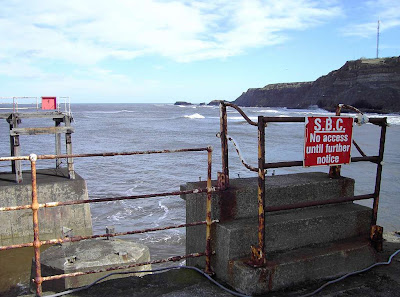
We were amused to find ‘etchings’ of fossils and dinosaurs in the concrete, also a concrete sculpture and the inevitable ship’s anchor. We were unable to walk the full length of the east harbour because a connecting bridge had been washed away in a storm somewhen or other, and the end left to go derelict. The notice said “No access until further notice” — only if you can fly, or jump like a kangaroo!
 We returned to the town, and to the lifting bridge across the River Esk. The bridge remained down the whole time we were there. I remembered the year we had brought our four children here — it was back in 1979, and they were then aged eleven, nine, seven and six. We were camping at Goathland and had taken them to a fish and chip shop on the west side of the river.
  Then we couldn’t get back over for ages because the bridge had gone up to let all the fishing boats back on the evening tide. We thought the spectacle was very exciting — there were a lot more fishing boats in those days. We crossed over, then diverted to the left because we had seen a tall ship harboured just a little further along the river on the west side. It was a brightly painted replica of some old ship called “Grand Turk”. It looked good, but I don't know if it was seaworthy.
 We followed the riverside to the west harbour, and this one we could walk along right to the end. We passed a tall stone column with a light and a weather vane on the top, and there is another light at the end matching one on the derelict side. The artwork this side is rather fine -- wrought ironwork on a gate which is the kind of Art I really like. It depicts ships on a rough sea, and declares “Tribute to Whitby Seafarers”. The wind had subsided by then and the sky began to cloud over. It was much warmer, and not nearly so bright. We could have walked back along a lower level with columns each side, but I saw a lot of green algae down there which put me in mind of Brighton Marina on Walk 5! So I declared it an unsafe path and we returned along the top.
 We passed a small pink Ferris wheel, really only for children, but it was closed like the other fairground rides. It was too early in the season.
 The sea was completely covering the beach, so we reckoned it was odds on that we would have to find a route over the top to continue northwards on our next Walk.
 We found a path up the steep hill, with a shortcut through a little tunnel, and it gave us a grandstand view over Whitby town with the bridge at its focal point.
 Near the top we came across a granite War Memorial, but felt saddened that it had no individual names on it and was situated in a rather seedy part of town. It looked as if it had been done on the cheap.
 Further on, prominence was given to a statue of Captain Cook. James Cook, that most famous of explorers, came to Whitby in 1746 aged eighteen. He was apprenticed to a local ship owner, and spent the next nine years serving aboard cargo ships which travelled between London, Liverpool, Dublin, Holland, Norway and the Baltic. That was how he learned to be such a fine seaman. Later on, all the ships he used for his voyages to the nether ends of the world were built at Whitby.
  A plaque on the plinth of his statue reads:

 We certainly weren’t in any danger of being blown off into the sea! (Nanny State at it again?)


We were amused to find ‘etchings’ of fossils and dinosaurs in the concrete, also a concrete sculpture and the inevitable ship’s anchor.
 We were unable to walk the full length of the east harbour because a connecting bridge had been washed away in a storm somewhen or other, and the end left to go derelict. The notice said “No access until further notice” — only if you can fly, or jump like a kangaroo!
 We returned to the town, and to the lifting bridge across the River Esk. The bridge remained down the whole time we were there. I remembered the year we had brought our four children here — it was back in 1979, and they were then aged eleven, nine, seven and six. We were camping at Goathland and had taken them to a fish and chip shop on the west side of the river.
  Then we couldn’t get back over for ages because the bridge had gone up to let all the fishing boats back on the evening tide. We thought the spectacle was very exciting — there were a lot more fishing boats in those days. We crossed over, then diverted to the left because we had seen a tall ship harboured just a little further along the river on the west side. It was a brightly painted replica of some old ship called “Grand Turk”. It looked good, but I don't know if it was seaworthy.
 We followed the riverside to the west harbour, and this one we could walk along right to the end. We passed a tall stone column with a light and a weather vane on the top, and there is another light at the end matching one on the derelict side. The artwork this side is rather fine -- wrought ironwork on a gate which is the kind of Art I really like. It depicts ships on a rough sea, and declares “Tribute to Whitby Seafarers”. The wind had subsided by then and the sky began to cloud over. It was much warmer, and not nearly so bright. We could have walked back along a lower level with columns each side, but I saw a lot of green algae down there which put me in mind of Brighton Marina on Walk 5! So I declared it an unsafe path and we returned along the top.
 We passed a small pink Ferris wheel, really only for children, but it was closed like the other fairground rides. It was too early in the season.
 The sea was completely covering the beach, so we reckoned it was odds on that we would have to find a route over the top to continue northwards on our next Walk.
 We found a path up the steep hill, with a shortcut through a little tunnel, and it gave us a grandstand view over Whitby town with the bridge at its focal point.
 Near the top we came across a granite War Memorial, but felt saddened that it had no individual names on it and was situated in a rather seedy part of town. It looked as if it had been done on the cheap.
 Further on, prominence was given to a statue of Captain Cook. James Cook, that most famous of explorers, came to Whitby in 1746 aged eighteen. He was apprenticed to a local ship owner, and spent the next nine years serving aboard cargo ships which travelled between London, Liverpool, Dublin, Holland, Norway and the Baltic. That was how he learned to be such a fine seaman. Later on, all the ships he used for his voyages to the nether ends of the world were built at Whitby.
  A plaque on the plinth of his statue reads:
THIS PLAQUE
WAS PRESENTED BY THE PEOPLE OF AUSTRALIA
TO THE WHITBY URBAN DISTRICT COUNCIL
TO COMMEMORATE THE BI-CENTENARY OF THE DISCOVERY
OF THE EAST COAST OF AUSTRALIA BY
LIEUTENANT JAMES COOK, R.N.
FROM THIS DISCOVERY EMERGED A NATION.
20TH APRIL - 22ND AUGUST 1770
UNVEILED BY
HIS EXCELLENCY THE HIGH COMMISSIONER FOR AUSTRALIA,
THE HON. SIR ALEXANDER DOWNER, K.B.E.
20TH APRIL 1970
Nearby is the famous Whitby whalebone arch, so we stood underneath it and asked a passerby to take a photo of us. There were fifty-five Whitby based whaling ships between 1753 and 1833. During this time more than 25000 dead seals and 2761 dead whales were brought back to the town. Boiler houses on the harbourside turned the whale blubber into oil. (Bet it was smelly!) This was then used to manufacture soap, margarine, paint, candles and it was even lit in street lights. Whaleskin was used for leather and cartilage for glue — no part of the whale was wasted.
 The ‘blurb’ also told us that the whalebone arch is made from a pair of blue whale jawbones obtained by Thor Dhal of Norway and Graham Leach of Whitby. They were erected in 1963 “in honour of the men of Whitby who braved the inhospitable seas in and around the arctic”. However, we found another almost illegible plaque nearby claiming they were bowhead whale jawbones presented to the town of Whitby by the Anchorage Sister Cities Commission and the citizens of the municipality of Anchorage, Alaska, in April 2002! So whose bones are they?
 The ‘blurb’ also told us that the whalebone arch is made from a pair of blue whale jawbones obtained by Thor Dhal of Norway and Graham Leach of Whitby. They were erected in 1963 “in honour of the men of Whitby who braved the inhospitable seas in and around the arctic”. However, we found another almost illegible plaque nearby claiming they were bowhead whale jawbones presented to the town of Whitby by the Anchorage Sister Cities Commission and the citizens of the municipality of Anchorage, Alaska, in April 2002! So whose bones are they?
Whitby is a very pretty town, full of interest, and we had thoroughly enjoyed ourselves!
That ended Walk no.129, we shall pick up Walk no.130 next time at the whalebone arch in Whitby. We walked back across the town to the car, and drove back to the cottage in Rudston for the last time. It is too far from where we are now walking to use it again — pity, because it is a roomy property in a quiet rural setting, and one of the few holiday cottages that has a dishwasher! The next day we packed up our stuff and returned to Bognor.

No comments:
Post a Comment