Ages: Colin was 65 years and 47 days. Rosemary was 62 years and 189 days.
Weather: Grey and murky with frequent heavy showers. A cold wind.
Location: North Queensferry, via Inverkeithing and Dalgety Bay, to Aberdour.
Weather: Grey and murky with frequent heavy showers. A cold wind.
Location: North Queensferry, via Inverkeithing and Dalgety Bay, to Aberdour.
Distance: 11½ miles.
Total distance: 1321½ miles.
Terrain: Mostly following a gravel or grassy path. Some tarmac. Fairly flat, but a few undulations.
Tide: Going out.
Rivers: No.86, Pinkerton Burn at Inverkeithing. No.87, Dour Burn at Aberdour — which was flooded.
Ferries: None.
Piers: None.
Kissing gates: No.134 in North Queensferry. No.135, a ‘wild deer’ swivel gate which I counted as one, as we approached Dalgety Bay. No.136 at the ruined church.
Pubs: We visited one in Inverkeithing because we needed a drink and a rest out of the rain (and a toilet where we didn’t have to pay!) but it wasn’t a ‘real ale’ establishment because Colin had neglected to look one up. He didn’t make that mistake again! In Dunfermline, on the day of that visit, we lunched at the ‘Commercial Inn’ and drank Theakstone’s ‘Old Peculier’ and Cain’s IPA.
‘Historic Scotland’ properties: No.5, Dunfermline Abbey and Palace. No.6, Inchcolm Abbey and Island. No.7, Aberdour Castle and Garden. (All of these we visited on different days.)
Ferris wheels: None.
Diversions: None.
How we got there and back: We drove up the day before to a holiday cottage in the village of Craigrothie which we had booked for two weeks. In the morning we drove to Aberdour where we parked near the beach and walked along the bottom of the cliffs to the station. We caught a train to North Queensferry, alighting in a torrential downpour! We then walked to the Forth Road Bridge, and climbed up to road level where we had finished the last Walk.
At the end we had a couple of cups of tea, then drove back to our cottage in Craigrothie.
 We have been living in Malvern for five months now, and are enjoying it very much. It is such a beautiful place, we have to keep pinching ourselves and saying, “No, this isn’t a holiday flat, and we haven’t got to return to Bognor at the end of the week. We live here!” It all seems so unbelievable. Why did we ever move away to Bognor back in 1968? (Actually, there were lots of reasons at the time but none of them are relevant today.) We are still living in the flat as we haven’t yet found a house to our liking that we can afford. We have looked at lots from the outside, viewed a few inside, but nothing has come up to scratch so far. We’d really like to live in Malvern Wells, near where we lived for sixteen months from 1967 to 1968, but houses in the village tend to be on the expensive side. Something is out there, we know. We’ll find it!
The weather was terrible this morning, slate grey sky, really cold and it was raining stair-rods! Not exactly walking weather. We were the only people to get on the crowded train at Aberdour station where it had been impossible to buy tickets as there was no one there and no machine.
 We were the only people to get off at North Queensferry station, and we hadn’t seen a ticket collector during the short journey. It was chucking it down as we alighted, but I saw the conductor further up the platform. Being very honest, I approached him and said, “We haven’t bought tickets!” He shook his head and answered, “Don’t bother!” We were so obviously dressed as walkers in all our wet-weather gear, I think he felt sorry for us. There is a large mosaic on platform 2 of North Queensferry station. Apparently it was unveiled in 1990 to celebrate the centenary of the Forth Railway Bridge.
We had some difficulty finding the best way from the station to the foundation stone on the road bridge where we finished the last Walk. It was raining so hard it was difficult to see the detail on the map. Everything is on such a steep slope it appears all crowded together, and neither of us have windscreen wipers on our glasses! However we made it, passing on the way an ancient stone spring which was restored by the Victorians. A plaque told us:

THIS ANCIENT SPRING
WAS RESTORED BY LOVERS OF THE FERRY
FOR THE SOLACE OF WAYFARERS
AND IN MEMORY OF SIXTY YEARS
OF HER MAJESTYS REIGN HAPPILY COMPLETED
1837 — 1897
1837 — 1897
 By the time we arrived on the road bridge, it had stopped raining temporarily. So we climbed up the 109 steps to the viewpoint so we could get a good view of the bridge before we started. We sat down and ate our pies because we didn’t know when it would start raining again. From our viewpoint we could also see the Railway Bridge through a gap in the trees.
Glancing back to the road bridge we couldn’t believe what we saw — a ‘sponsored walk’ seemed to be taking place across the suspension bridge,
 and it involved children aged about twelve! In this weather? I am no fan of the petty health and safety regulations which blight our modern-day life, but surely the event should have been called off? We were frozen where we were and had difficulty standing up against the wind, and we weren’t even on the bridge. Adults were greeting the inadequately dressed youngsters as they arrived on our side and handing out buns. Colin saw one girl drop her bag of buns off the side of the bridge! It all seemed crazy, it’s a wonder they didn’t have a few cases of hypothermia.
 We descended 251 steps to the water’s edge, passing a memorial bench placed there in 2005 by North Queensferry Community Council.
  We were told it was ‘In memory of Those who died Building the Forth Bridges’. At the water’s edge, almost under the road bridge, was another memorial. This was a tree planted ‘In loving memory of our beautiful daughter, Kelly Kennedy, died 11.3.94, aged 14. Just a thought away.’ Lovely idea, to plant a tree — far better than a bunch of dead flowers in cellophane.

 We walked along to the old railway pier where a Scottish flag was flying. The famous cantilever bridge was not built until the railways criss-crossing Britain had been in service for about fifty years. Until the 1890s, passengers had to alight on the south side of the river, cross the Firth of Forth by ferry, and then board a different train on the north side to continue their journeys.
  I wasn’t sure if it was this railway pier that was used by the car ferry when we crossed with my parents in 1964, or whether it was the Town Pier further on. We got talking to a local man who showed us old pictures of the bridge and the ferries in an adjacent building where he was setting up an exhibition. They were very interesting, but they didn’t make it any more clear which pier was used.
 We walked round some greenery where there was an old boat, and near the road we passed a redundant toilet block. It was covered in graffiti bearing the legend, ‘ALL YOU NEED IS LOVE’. I’m sorry, but at our age if you’re dying for the toilet you need something more than love — you need a place to GO! Fortunately Colin had been able to find a discreet bush
  (with his artificial sphincter, when he’s got to go he’s got to go!) and I didn’t feel the need at the time.
Coming out into the road, an official road-sign type notice told us, ‘Notice is hereby given that the public has a right of pedestrian access at all times during the hours of daylight, to the piers comprising the former ferry pier and town pier and the amenity area adjoining the bay, for the purpose of walking thereon and sightseeing.’
 Nice to know that what we were doing was legal, but why did we need to be told? Surely it was obvious? Especially with the open access laws being so liberal in Scotland.
We then walked round to the Town Pier, and found several historical artefacts of interest. We passed ‘Willie’s Well’ which had a plaque saying simply ‘North Queensferry Historic Wells’, so we have no idea how old it is.
 Next we came to an ancient milestone telling us we were 11 miles from Edinburgh, 33 miles from Perth (we think, because it was difficult to read), and there was a lump chiselled out of the third place making it quite illegible. A modern notice next to it told us the Town Pier was the oldest pier in the village, and that it was rebuilt between 1810 and 1813 by the engineer John Rennie.
 The lantern tower was in such good shape it looked as if it could still be used, though it is really only a museum piece in this modern electronic age. We were told it was built in 1812, and used in all weathers to guide ferry vessels to the Town Pier. And then we came to the boundary wall of a sailor’s cemetery
 which had an inlaid stone bearing the legend, “This is done by the sailers in North Ferrie 1752”. That is the date it is believed the local sailors adopted the grounds of the ancient St James’s Chapel for their cemetery. The chapel itself was gifted to Dunfermline Abbey in 1320-23 by Robert the Bruce. Only a fragment of it remains today.
 We looked at the Railway Bridge from the Town Pier, then we walked underneath it and tried to get as close as we could to see the work they are doing on it. It is made from 51,000 tons of steel, 5 million rivets, and requires 7 thousand gallons of paint to cover it. It’s cantilever style is a marvel of Victorian engineering, and since it is in such constant use it is very important that it is preserved — especially as it looks as if we may lose the road bridge in a few short years. The legend that they never stop painting it because it takes two years to do so
  and then they have to start again, may be a thing of the past. The work that is going on now is to blast off all the layers of old paint down to the original steel, then coat it in a modern plasticized paint which can withstand many years of Scottish weather. The traditional rusty red colour will be kept. The engineers are hopeful that this will preserve the bridge in good condition for many more years, if not centuries, to come. If only they could think of a similar scheme to preserve the road bridge, but because the rusting wires are inside the cables, they can’t. Does that mean that our Victorian forefathers were better engineers than the modern breed with all their computer-based technology? I think it does!
We had spent a lot of time faffing around in North Queensferry which made us late for the rest of the Walk, but it had been so interesting we were reluctant to tear ourselves away. We had difficulty finding the coastal path which is marked with green diamond-shaped blobs on the OS map. The ‘kingdom’ of Fife has the only way-marked bit of coastal path in Scotland, so navigation should be much easier on this series of Walks, all the way round to the Tay Bridge. That is what we were hoping, anyway, but we couldn’t find our way out of North Queensferry. We found ourselves at the entrance to ‘Deep Sea World’ — which we didn’t have time to explore — and couldn’t get round behind it. Then we found ourselves on the wrong side of an inlet. At last we found the path — it was not very obviously signposted.
 It was a pleasant path, partly up the cliff and leading through some old quarries. They used to quarry a stone here called whinstone. It is a solid quartz dolerite, and can be cut easily into slabs, sets and kerbs — in fact much of London’s pavements have been made from it. It was also used to make the bases of the pillars holding up the Forth Bridge — a truly local stone.
We stopped to chat to a man with two dogs, and told him about our Coastal Trek. It turned out he knew the South coast very well, especially Littlehampton and Eype Mouth where one of our favourite campsites is layered on the clifftop. Our very first Walk, back in 1998, ended in Littlehampton.
 By the time we get to Eype Mouth in Dorset we shall have almost completed our circuit. We shall probably be well into our seventies by then — I wonder if we’ll still be camping in a tent! A few weeks ago we went down to our daughter, Maria’s, house near Lymington to collect our camping gear which she had been minding for us while we moved house. The idea was to stay with her over the weekend, then drive along to Eype Mouth and camp there for a few days. The weather was dreadful, cold, grey, wet and windy (bit like today, really). We didn’t fancy camping at all, so after the weekend we drove straight back to Malvern and stored our camping gear in our over-stuffed flat. Hopefully we’ll be able to use it before the Summer is over, but not in weather such as we were experiencing on this Walk!
The pleasant path through trees that we were walking on gradually turned grotty as we approached Inverkeithing, a forgettable place! We passed through quarries and a scrapyard, then into the town. It started to rain once more, and it was really cold. Besides that, I needed a loo. The public toilets in Fife are a disgrace! All the ones we have passed so far are those ‘automatic’ cabin-type ones that we hate. When we were in Aberdour this morning parking the car, I had been in a ‘desperate’ state — which I often am in the mornings even though I go several times before we leave (I put it down to old age!) The only place I could go was one of these ‘space-age’ toilet cabins, so I reluctantly put 20p into the slot to open it up. (How I object to having to pay for something which is such a basic need!) These cabins are supposed to be self-cleaning, whizzing round the cleaning fluid after you have left to leave the cabin in a pristine state for the next customer. What I found was a bad smell and bits of used toilet paper and poo stuck to the walls!! It was absolutely disgusting, and I shall never use such a place again. I shall do what Colin does, and make use of a municipal bush — I’d rather, even if I was seen. Shame on you, Fife Council!
 Anyway, getting back to Inverkeithing, I wanted to find a pub where I could have a sit-down, a warm, a drink and a free loo. Colin is responsible for looking up the location of ‘real ale’ pubs, but he hadn’t done his homework and he couldn’t find out if there were any ‘real ale’ pubs in Inverkeithing. He asked the smokers standing in the doorways of a couple of pubs, sucking on their fags as if their lives depended on it and trying to keep out of the rain. But I’d had enough, and insisted we enter a ‘keg’ pub where I had a ginger beer and he sat miserably until I was ready to continue. He never neglected to look up the pubs in advance of our Walks again!
Dunfermline

 Dunfermline Abbey and Palace is an ‘Historic Scotland’ property. We didn’t have to visit it because it is more than a mile from the coastal path, but we did on one of our ‘rest’ days and I have included it because it was interesting. At least it didn’t rain the day of our visit, but it was cold, like Winter, despite it being the end of June. Whatever happened to Summer? On June 25th I wrote in my diary — “There has been torrential rain in the Midlands, especially in South Yorkshire. Sheffield has been washed out — people winched into helicopters from their factory roofs! A
  thousand homes are flooded out and three people have died.” The next day I wrote — “The floods are really bad — a bridge has washed away in Ludlow, Worcester is under water, and a man died in his car when washed away near Pershore! A reservoir in Nottinghamshire has cracks in the dam, the M1 is closed and several villages were evacuated in the middle of the night!” We visited Dunfermline on June 28th.
We parked (for free) in the middle of the town and first of all went to one of Colin’s ‘real ale’ pubs where we had a very nice lunch. Then we found our way through the lovely park to the old Abbey. As soon as we entered we were reminded of Durham Cathedral because of the beautiful pillars. It’s an amazing building, those medieval stonemasons really were something! And they did it all without modern lifting gear or computers.
 There
There  has been a church on the site since the 9th century, but the present Abbey church was built in the 11th century. Benedictine monks from Canterbury were invited by King Malcolm III to set up a community there. The church was added to in subsequent centuries, the impressive nave was constructed in the 12th century by Malcolm’s son, King David I, to honour his mother, Queen Margaret. In 1150 the Priory was raised to Abbey status. The Abbey contains the graves of many kings of Scotland, including the famous Robert the Bruce. At the Reformation, the Abbey was taken over by the Presbyterian Church of Scotland, and for some years was
  administered by lay commendators. Later it was annexed to the Crown by James VI, who became James I of a united Britain. The Abbey is still a functioning church to this day and is administered by the Church of Scotland.
The monarchs lived in the palace next door, which was formerly the Abbey guest house. Charles I was the last British king to be born there.
 The palace was sacked by Cromwell’s troops and stripped of its roof. It has been a ruin ever since, and is now looked after by ‘Historic Scotland’.
In the grounds we came across several interesting plaques. One told us that
 “Margaret, mother of William Wallace, lies buried beneath a thorn tree in the grounds of Dunfermline Abbey”. Another commemorates the 158 people who died in the outbreak of cholera which swept through Dunfermline in 1832, and informed us that these victims were buried hereabouts. A third gave a résumé of the life of Charles I (who was born at Dunfermline), and speaks of traditional stories reporting evil portents during his infancy, such as “a bloody cloak was said to have blown in through a window and rested on the child’s cradle”! An over-active imagination was at work telling the tale in hindsight after Charles was executed at the age of 49, I would say.
 We enjoyed our tour of both the Abbey and the Palace in Dunfermline, but we couldn’t get over how cold it was, like Winter. So we didn’t stay long, especially the outside bits, and soon drove off to do something else.
 Back in Inverkeithing, we left the ‘keg’ pub when we felt a little warmer and more comfortable, but were immediately hit by the cold damp air outside making us think it was midwinter, not midsummer. We passed the ‘Mercat Cross’ which was erected around 1400. Under these market crosses, which are all over Scotland, the important business of the towns took place in yesteryear. Hope they had more clement weather than we were ‘enjoying’ when we walked past!
 We crossed the river and walked down to the waterfront again through a sports’ ground. We hardly seemed to have progressed any distance beyond the Railway Bridge, and it was already three o’clock. We were quite hungry, having not eaten anything since our pies at the start of the Walk.
  We were passing through yet another disused quarry, and there were puddles everywhere. We looked around, and eventually found some stones that it was possible to sit on out of the wind. So we ate our sandwiches, but moved on quickly because we were not very comfortable. After a mere fifty yards we turned a corner — and there we were confronted with no less than three lovely benches with a view and in a sheltered position!
 Feeling
 just a little exasperated, we continued along the coastal path. The flowers were telling us it was Summer
  and the weather was telling us it was Winter, and we were somewhat confused. So when we got to an odd looking swivel gate with a notice warning us about wild deer (we didn’t see any) I counted it as a kissing gate to make me feel better!
 We continued towards Dalgety Bay, which seems to consist entirely of a new housing estate with dwellings three or four storeys high. I believe they call them ‘Town Houses’, but they must be all stairs inside. They have pocket-handkerchief size gardens because the builders have squashed the maximum number of houses in the smallest possible space. Wouldn’t do for us, we are looking for an old-fashioned bungalow with a larger than average (not huge) garden and above all — privacy! Wouldn’t mind a view, but that is not
  essential. Town houses and flats are not our thing, we are only living in a flat now as a temporary measure. Fortunately our neighbours are very quiet, and the old couple above us have been taken off to a home for the bewildered so we don’t even hear footfalls across our ceilings. However the plumbing is all connected, and everybody’s bath/shower water comes tumbling noisily
  through our bathroom at all hours of the day and night. We must find a house, preferably detached.
There was a pleasant tarmac path in front of the houses which, I must admit, have stunning views of the Forth Bridge. We came to a rocky promontory on which there was a cross — of a religious type, we think. When Christianity first came to these shores there were no churches.
 So stone crosses were erected in prominent places and sermons were preached beneath them urging the people to drop their Pagan beliefs and take up the Cross of Jesus. We wondered if this was such a cross.
 As we neared the eastern side of Dalgety Bay, the houses got bigger and posher,
  one or two with really ornate gateways. Despite the grey skies, we had good views across the Firth of Forth, back to the Forth Bridges, and of Inchcolm Island just off the coast past a gas terminal which was coming up. We walked across the grass in front of all these dwellings, then through a wood. By the time we reached the ruined chapel of St Bridget we were frozen to the bone again. Whatever happened to Summer?
 We
We  explored the roofless chapel and its graveyard excitedly like small children in an attempt to cheer ourselves up. The cold was making both of us feel quite depressed. Then we sat quietly on the grave of Alexander Leslie, who died in 1795 aged 73, to eat our chocolate.
We hope you didn’t mind, Alexander! A notice told us: “There was a parish here by at 1165-79, because it was granted to the priory (later the abbey) of Inchcolm by King William the Lion at that time. For much of the middle ages the spiritual needs of the Parish’s layfolk were served
 by one of the canons of Inchcolm. The church remained in use by the parish after the Reformation, but was eventually replaced by a new building on a more convenient site in 1830.”
It was impossible to get any further along the beach from the chapel, so we had no choice but to turn inland and follow the official coast path.
 It took us through fields with cows grazing, and cut off a whole peninsula on which a gas terminal was hidden behind the trees. We ignored a signposted footpath to ‘Braefoot’ as it wasn’t marked on our map.
  We could hear the ‘hum’ from the gas terminal, and used the excuse that it is an ‘industrial’ site not to go that way, also because it may well be a dead end with no other way out. Really, we were just too tired by that stage of the Walk to make mistakes and have to retrace our steps.
Inchcolm Island

 Inchcolm Island is situated in the Firth of Forth, directly opposite the ugly gas terminal between Dalgety Bay and Aberdour. We visited it on July 4th, by which time the weather had remembered it was Summer and put on a show of blue skies and warmth. Just the day for a boat trip!
 We parked at North Queensferry station, and didn’t have long to wait for a train to take us across The Bridge to Dalmeny station. Then we couldn’t find our way down to Queensferry which was only a quarter of a mile away. We got down to a disused railway — we think it predated the Forth Bridge — which is now a cycleway.
  Colin found some steps down through the woods which were steep and slippery. At the bottom we were met by a man who said we were in a private garden. Then he said he was “only a visitor” and it turned out to be a pub garden anyway. So we got down to the boat pier (probably the one we had taken the car ferry from in 1964) and bought our tickets. The boat took us out into the Firth of Forth, and under The Bridge to Inchcolm Island. It was glorious! The sun shone, it was warm, and we saw lots of birds, including puffins, and also seals in the water and on the rocks.
 On the island we explored the ruins of the old priory and climbed the steepest narrowest spiral staircase we have ever been up. It was a bit like caving, perhaps people were smaller in those days! We climbed the tower and took photos all around, including the Forth Bridge, Edinburgh with Arthur’s Seat rising from its centre, and even the gas terminal. We explored the grounds and admired the flowers.
 Inchcolm Priory was built by Alexander I in the 12th century, in gratitude to a resident hermit who had given him shelter. It was elevated to Abbey status in 1235. It was constantly invaded by the English, especially during the 14th century, and
  sometimes the canons were forced to live on the mainland to avoid marauding forces. At the Reformation the monks were ousted and the property was given to one James Stuart. It was turned into a residence by his descendants. In 1795 it was used as a barrack, and was not well looked after. In the 19th century the abbey eventually fell into ruins. The state took it on in 1924, and the island is now managed by ‘Historic Scotland’. Because of its strategic position, the island was fortified as part of Rosyth naval base during both World Wars.

 Colin wanted to find puffins, so he took a grassy path along to the end of the island while I watched some fluffy gull chicks sitting on a step. He didn’t find any puffins, instead he got s**t on by gulls! We both went round the other side of the island looking for these elusive ‘clown-birds’, but to no avail. The gulls were very noisy and aggressive, and I was not happy!
 We
We  had a lovely trip back to Queensferry on the little boat. Then we went to the ‘Ferry Tap’ for some real ale. We were peckish, and the landlady made us toasted sandwiches even though it was out of time. We found the proper way back to Dalmeny station, and caught a train back across The Bridge. As we left North Queensferry to drive back to our cottage, it started to rain.
That was Summer 2007, finished and done with !
 Back to the Walk. The path we were on was also a cycleway, which meant it was mostly tarmac. We found this boring, or perhaps we were just tired. We were certainly cold! We passed a golf course and walked into Aberdour. We passed a very ornamental gate as we entered the town.
  That is when it started raining again, and we were really miserable! But we were determined to finish.
We went down to the harbour and grimly walked the harbour wall. Then we crossed the flooded river and walked round the bottom of the cliffs to the end of Hawkcraig Point (it was actually a lovely path, we had walked it this morning from the car park to the station) where we could overlook Silversands Bay. We passed a concrete bunker on which was placed a lovely bouquet of white flowers. The tag on it said they were from the funeral of “Mummy” who died two days ago. How sad!
  The bereaved couldn’t have known what to do with the flowers after the funeral, so left them there as some kind of gesture. I still think flowers at a funeral are a complete waste of money, I shall request in my will that my children plant a tree instead. At least that is a living thing which will go on and on, and be of benefit to those I leave behind. We walked down the road to the car park at the end of the beach.
 That ended Walk no.159, we shall pick up Walk no.160 at the car park next to Silversands Beach in Aberdour It was a quarter to seven, so the Walk had taken us seven and a quarter hours. We had a some tea from our flasks, then drove back to our cottage in Craigrothie where we had to put the heating on to get warm — on Midsummer’s Day!

 We
We  visited Aberdour Castle on one of our ‘rest’ days, but the weather was just as cold, wet and miserable that day. The ‘Castle’ is really a fortified manor house first built in the 13th century. Over the next 500 years it was owned by three different families who improved and extended it in their own styles.
  It fell into disrepair in the 18th century, and is now a ruin.
There is a 17th century painted ceiling preserved in one of the rooms, but it was too dark and difficult to photograph. (This picture is taken off the notice board, it is not mine.) The ceiling was commissioned by the 7th Earl of Morton to show how powerful, wealthy, educated and cultured he was.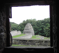 Impressive attributes in those days, but considered arrogant and toffee-nosed today!
The ‘Castle’ has extensive gardens which are well maintained. There is also a beautiful dovecot looking like an old-fashioned beehive made of stone.
 Back to the Walk. The path we were on was also a cycleway, which meant it was mostly tarmac. We found this boring, or perhaps we were just tired. We were certainly cold! We passed a golf course and walked into Aberdour. We passed a very ornamental gate as we entered the town.
  That is when it started raining again, and we were really miserable! But we were determined to finish.
We went down to the harbour and grimly walked the harbour wall. Then we crossed the flooded river and walked round the bottom of the cliffs to the end of Hawkcraig
 Point (it was actually a lovely path, we had walked it this morning from the car park to the station) where we could overlook Silversands Bay. We passed a concrete bunker on which was placed a lovely bouquet of white flowers. The tag on it said they were from the funeral of “Mummy” who died two days ago. How sad!
  The bereaved couldn’t have known what to do with the flowers after the funeral, so left them there as some kind of gesture. I still think flowers at a funeral are a complete waste of money, I shall request in my will that my children plant a tree instead. At least that is a living thing which will go on and on, and be of benefit to those I leave behind. We walked down the road to the car park at the end of the beach.
 That ended Walk no.159, we shall pick up Walk no.160 at the car park next to Silversands Beach in Aberdour It was a quarter to seven, so the Walk had taken us seven and a quarter hours. We had a some tea from our flasks, then drove back to our cottage in Craigrothie where we had to put the heating on to get warm — on Midsummer’s Day!
Aberdour Castle

 We
We  visited Aberdour Castle on one of our ‘rest’ days, but the weather was just as cold, wet and miserable that day. The ‘Castle’ is really a fortified manor house first built in the 13th century. Over the next 500 years it was owned by three different families who improved and extended it in their own styles.
  It fell into disrepair in the 18th century, and is now a ruin.
There is a 17th century painted ceiling preserved in one of the rooms, but it was too dark and difficult to photograph. (This picture is taken off the notice board, it is not mine.) The ceiling was commissioned by the 7th Earl of Morton to show how powerful, wealthy, educated and cultured he was.
 Impressive attributes in those days, but considered arrogant and toffee-nosed today!
The ‘Castle’ has extensive gardens which are well maintained. There is also a beautiful dovecot looking like an old-fashioned beehive made of stone.


No comments:
Post a Comment