Ages: Colin was 68 years and 8 days. Rosemary was 65 years and 150 days.
Weather: Mostly sunny, occasional light showers. Breezy in exposed places.
Location: Kyle of Lochalsh to the Isle
of Skye.
Distance: 15 miles.
Total
distance: 2291 miles.
Terrain: The Skye Bridge
near the start. Then it was all roads,
but we were able to walk on a lot of ‘old roads’ away from the traffic because
the roads on Skye have recently been upgraded.
Slightly undulating.
Tide: Out, coming in later.
Rivers: No.255, Kyle Akin. No.256, Abhainn Lusa. + many streams.
Ferries: None.
Piers: None.
Kissing
gates: None.
Pubs: None.
‘Historic Scotland’ properties: None.
Ferris wheels: None.
Diversions: None.
How we got there and
back: We were staying in our caravan at
Reraig, and we had hired a second car locally.
This morning we drove both cars to the Isle of Skye
and parked our own car next to a church near Isleornsay. We then drove the hire car back to the car
park in Kyle of Lochalsh where we finished yesterday’s Walk.
At the end, we
came to our car parked by the church, overlooking Ornsay and the Sound of Sleat
towards Knoydart. We had tea and caramel
shortcake, then returned to our caravan in Reraig. We left the hire car parked in Kyle of
Lochalsh.
I have Colin’s cold! (He has more
or less recovered from it now.) I woke
up this morning feeling really rotten and seemed to have no energy all
day. But we have to carry on because we
have come so far and hired this expensive second car.


From the car park by the Leisure Centre in Kyle, we walked down to the
traffic lights and turned right. The
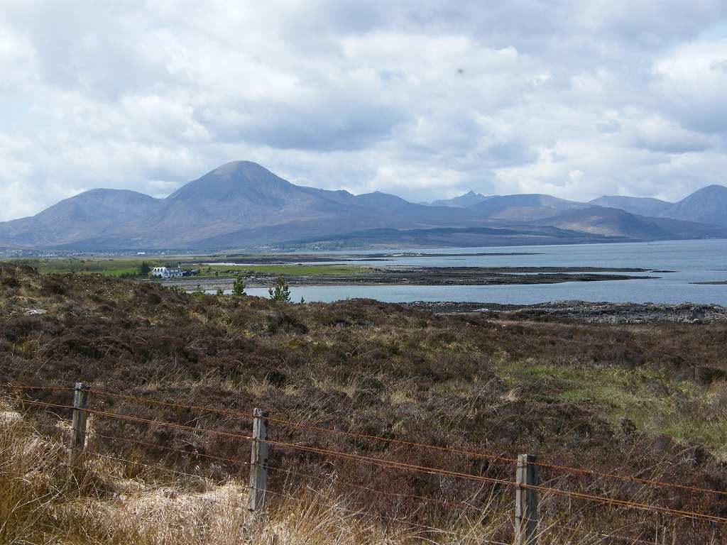
road goes through a cutting on a rocky peninsula from where we had magnificent
views in all directions. Across the
strait nestled the hamlet of Kyleakin.
Behind us stretched the mountain-rimmed water of Loch Alsh.
Ahead of us we could see the beautiful curve of the Skye Bridge
with the Cuillin mountain range in the background. It was breathtaking!


The road first crosses a low bridge on to a rocky island. Just before we rose up to the second bridge,
the humpy one, we passed a lighthouse below.
On the main bridge a Japanese couple asked us to photograph them, so we
did then asked them to return the favour.

But the fellow zoomed in and cut our feet off, so I had to ask him to
take the picture again. Once more he
played with the zoom, and I had to ask him to do it a third time. I explained, with much gesticulation because
his English was poor, that we wanted all of us in the photo, not just our faces. Even then he couldn’t keep his fingers off
the zoom, so I had to be satisfied with the third picture he took — I was
exhausted by then!

The Skye Bridge was built in 1995, putting an end
to long queues for the ferry between Kyle of Lochalsh and Kyleakin on the other
side. A toll was charged to pay for the
bridge — after all, everyone had to pay for the ferry when it was in
operation. Fair enough, but the toll
went up and up until it cost £11.40 to drive a car across. It was the highest bridge toll in the world! The bridge had long since been paid for, but
still the toll remained at this high level.

Of course the locals objected.
They couldn’t afford these exorbitant fees to get off the island — and
the tourists weren’t coming, plunging their economy into the doldrums. They formed an association which organised
peaceful protests, many of them refusing to pay as they drove across the bridge. They were heavily fined, and some even went
to prison for refusing to pay these fines.
Eventually they dressed in their full Scottish finery — kilts and all —
and took their bagpipes on to the bridge (I didn’t say it was a silent protest,
just a peaceful one!) There they blocked
the road to all vehicles and continued playing their bagpipes until the
authorities gave in. They won! And now it is free to cross the bridge on to
the island.

But is Skye now an island? It is
connected to the mainland by a bridge, so should we have to walk round it if we
are to walk all of the coastline of mainland Britain? We mulled over this question for many an
hour, studying the maps and discussing what we should do.

There was another problem in the area — Knoydart. Knoydart is on the mainland, but is
completely cut off from the rest of Scotland by mountains. There is a small network of roads around the village of Inverie, but there are no roads leading
to it — all vehicles have to be taken there by ferry. Knoydart is only accessible by ferry (usually
from Mallaig) or by walking for two days across the mountains. To go by road from Kyle of Lochalsh to
Mallaig would involve a journey of well over a hundred miles inland! There is simply no coastal path.

Using the ‘rules’ we have made up for this trek, we
found a brilliant way of solving the problems of both the Skye Bridge
and Knoydart. Additional rule no.5
states: An island connected by a bridge is part of the mainland and must be
walked around. So we had to cross
the bridge on to Skye. Additional rule
no.2 states: We do not have to walk down a dead end which involves retracing our
steps if we don’t want to. So when
we get to the junction with the A851, a mere six miles away, we can turn left
on to it because the road continuing towards Portree and the rest of Skye is
effectively a dead end and we would have to retrace our steps for miles to get back
to that junction. Main rule no.5
states: If there is a ferry which crosses a river or an estuary, we may use it.
If we count the Sound of Sleat as an
estuary, then we can use the ferry from Armadale to Mallaig.
Sorted!
In addition (as if we needed any other excuse!) we had
just made up a rule which states: While we are still in Scotland, where
the footpath infrastructure is primitive and unmapped for the most part, we
will only walk along way-marked footpaths, tracks or tarmacked roads in the
interests of safety. No more vague
footpaths nor walking across rough country.
So we didn’t have to walk for two days across the mountains, sleeping in
a bothy on the way, to get to Inverie.
And if we did do it, we would still have had to catch a much longer
ferry to Mallaig — so that idea was a non-starter. As for walking over a hundred miles along
roads to get to Mallaig……!……?

There was the remains of a redundant petrol station just
across the bridge where we found a wooden seat.
So we sat on it to eat our pies.
Then it was a long boring walk along a main road for six miles to the
junction where we could turn off. I
wasn’t feeling at all well with my wretched cold. Crossing the bridge was the highlight of the
whole Walk, all the rest was drudgery — but perhaps feeling so under the
weather made me feel like that. I now
knew why Colin had been so tetchy on the Walk before last!


That ended Walk no.247, we shall pick up Walk no.248
next time by the church at Isleornsay.
It was ten to seven, so the Walk had taken seven hours forty
minutes. We had tea and caramel
shortcake, then returned directly to our caravan in Reraig. We left the hire car parked in Kyle of
Lochalsh from where we’ll pick it up tomorrow as we drive through.

No comments:
Post a Comment