Ages: Colin was 75 years and 133 days. Rosemary was 72 years and 275 days.
Weather: Fine.
Gentle breeze. Mostly sunny,
getting quite warm later.
Location: West Dale to St Ishmael’s.
Distance: 11 miles.
Total
distance: 3924 miles.
Terrain: Cliff
top paths, undulating. Quiet roads,
slightly undulating.
Tide: Out,
coming in. Too far in when we needed it
to be out!
Rivers: No.452, Afon Dale (my name for it because
it wasn’t named on the map).
Ferries: None.
Piers: None.
Kissing gates: Nos.936, 937, 938 and 939 around St Ann’s Head.
Pubs: The Griffin Inn in Dale where Colin drank
Evan Evans “Cwrw Haf 40” and I had a shandy.
‘Cadw’ properties: None.
Ferris wheels: None.
Diversions: No.84 near Dale. We couldn’t get across the river because the
tide was too far in, so we had to go round by road which was further and
boring!
How
we got there and back: We were
caravanning near Whitesands
Beach. This morning we drove to St Ishmael’s where
we parked by a toilet block and children’s playground on the edge of the
village. We caught the bus from there to
Dale where we alighted near the church.
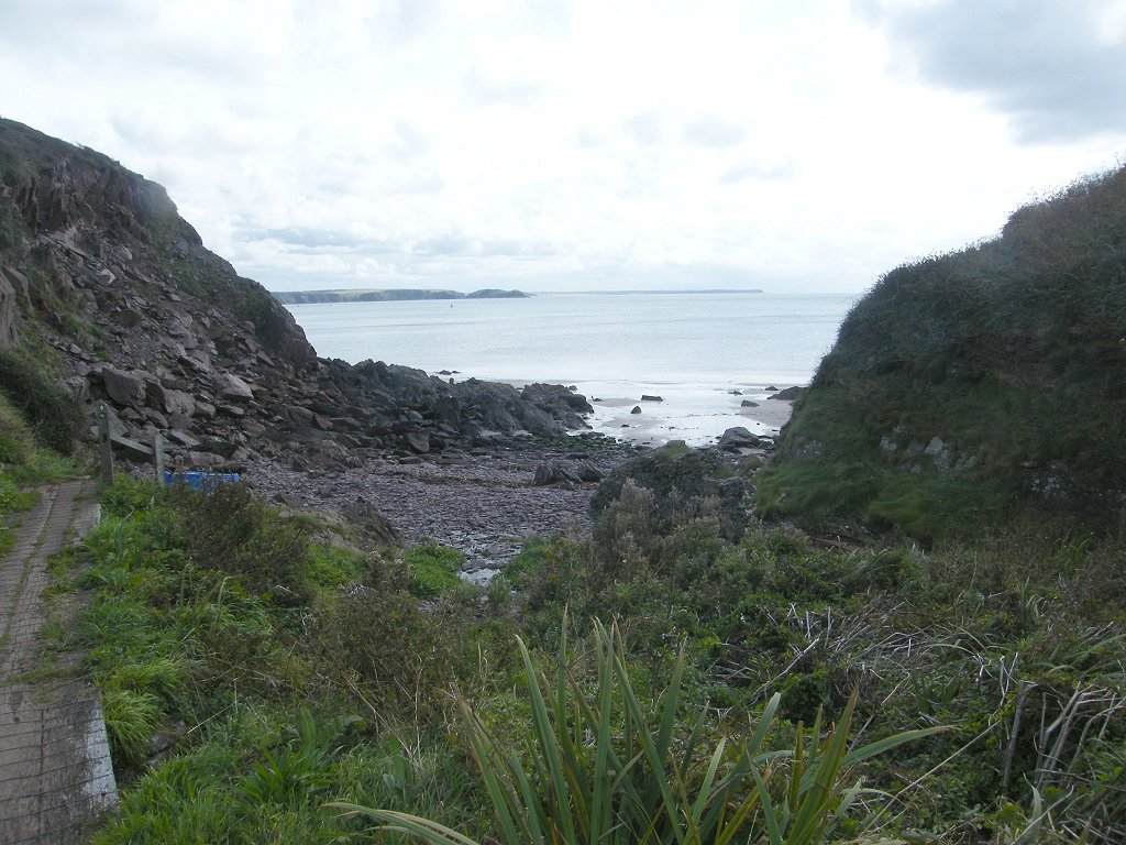
From there we walked westwards down through the sugar beet field to the
coast path.
At
the end we came to the car having just walked through St Ishmael’s
village. We had our tea and chocolate
biscuits, then returned to our caravan at Whitesands.
At the beginning of this Walk we had to climb a lot of steps up a hill,
but when we got to the top it remained pretty level all the way through to St Ann’s Head. We didn’t meet very many people until after
we had passed St Ann’s
Head.
We were enthralled by the geology
in the cliffs, every corner we turned opened a new vista. We sat on a rock to eat our pies and soak in
the wonderful views.
As we approached St Ann’s
Head there were a plethora of notices reminding us that it was private property
and “keep
to the footpath”—YES SIR!
We passed the old lighthouse building and
followed a not-very-obvious signpost pointing to a viewpoint along a narrow
fenced path. We remembered coming here
with the U3A Geology group in 2011. Our
coach parked by the lighthouse building, and we may well have missed the
signpost today if we hadn’t remembered coming here back then. It didn’t look very much from the signpost,
but just round the corner we came to view a spectacularly folded cliff
face. I remember it was extremely windy
when we came here six years ago, and I didn’t feel safe. I took a quick photo
whilst clutching the fence, terrified that I was going to get blown off the
cliff. Then I went back to wait for the
others in the coach. There was no such
wind today — we were able to enjoy the full spectacle in sunshine and a gentle
breeze. We didn’t have a professor
explaining the outcrop today, but we couldn’t hear him back then anyway because
the wind was too noisy! Back on the Coast Path we passed even more notices reminding us that it
was private property and “keep to the footpath”. But we realised the houses here are all
holiday cottages, hardly disturbing the local residents! As we left the area we
passed a walled-off rectangle that we thought might once have been
allotments. It is all overgrown with
brambles now — sad! We passed a notice about Henry Tudor, the father of the infamous Henry
VIII. It said: “HENRY
TUDOR Earl of Richmond landed at Mill Bay
on 7 August 1485 with 55 ships and 4000 men landing at Dale. Travelling through West
Wales and gathering support, he then struck east. On 22 August 1485 Henry defeated Richard III
at the Battle
of Bosworth, and became King Henry VII founder of the Tudor dynasty.” I never really knew where Henry Tudor came
from, nor what his claim to the throne was.
I think it may have been through the female side of his family. We came to a cleft — Oh dear! My
poor knees! When we had climbed out the
other side of it we sat on a bank to eat our rolls. We carried on, walking to the end of the next
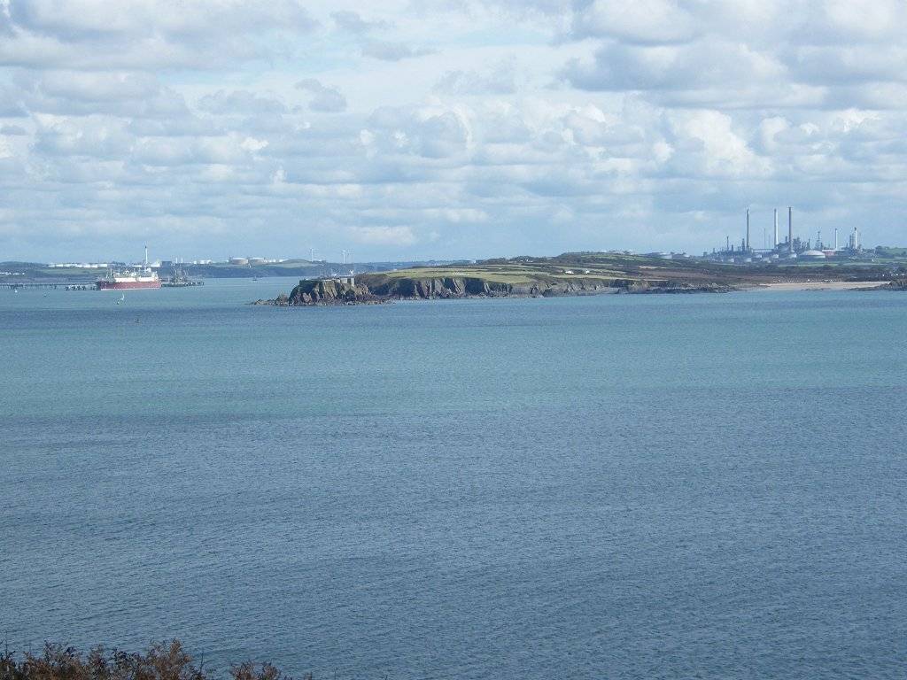
headland where there were some radio aerials.
We thought they were probably to do with navigation at the entrance to
Milford Haven — we saw a big oil tanker enter later. We could clearly see West Angle Bay across the water. It didn’t seem far away, but we knew we will
have a lot of walking to do before we reach it. We passed what looked like a fort on a little headland, and wondered
whether it was a lookout post from the Second World War. Milford Haven would have been very vulnerable
at that time. We soon came to another
cleft, but this one was gentler and not so deep. A group of students were on the beach. They came up to the path just in front of us
and marched off ahead much faster because of their youth. We speculated that they were University
Geology students based at Dale Fort Field Centre, but we didn’t know. The next headland had a tall light on it, again we thought it had a
connection with Milford Haven. Two
clefts followed, but neither was too deep.
The second one was in a pleasant wooded vale. Then we walked up to the final headland which
was very narrow and ended in an ancient fort.
We didn’t have to go up to the fort because it was a dead end, and when
we did try to go up there on one of our ‘rest’ days we found that it is being used as
a private field centre and inaccessible. A quiet road took us down from there into Dale village. As we entered the village I glanced through a
gateway and caught sight of the face of Jesus Christ carved in wood. Intrigued, we stopped and peeped in. it was a wood workshop but out in the open. It was very untidy and there was a carved
crocodile on top of the gateway. On the
opposite side of the road was an open shed containing lots of faces carved in
wood. Most of them reminded me of that
painting “The Scream”! It was all a bit
weird, and there was no one about. We carried on and passed a pub.
Since I was hot and tired I said to Colin, who had walked straight past,
“I fancy a shandy!” He admitted he
hadn’t previously looked up any pubs — he used to be meticulous about it. We went in and found it sold real ales, and
subsequently Colin discovered it was in the Beer Guide. We sat outside in the shade and enjoyed our
drinks. Further on we came across a painted wooden structure for children that
was supposed to represent part of a ship.
We put Thomas the Travelling Teddy on there for a photoshoot. Then we sat on a bench and lazily ate our
apples.
We marched on up the road, which was quite busy, to some lime kilns,
dating from the 18th and 19th centuries. A notice told us that limestone from the
quarries by the Cresswell and Carew rivers and coal from Cresswell Quay were
transported downstream to Dale. The
boats beached opposite the kilns and offloaded their cargo into carts. It was then taken to the top of the kilns to
feed the furnace. Activity came to an
end over a hundred years ago. We crossed a shingle bank to the river.
There is supposed to be a footbridge there, but it is submerged at high
tide. Water was already covering
it. Colin removed his boots and waded
across to see what it was like. He got
to the other side with water up to his ankles, but when he turned round to
return he felt the pull of the current on his legs. He only got back with difficulty. Meanwhile the water was getting deeper and
the current stronger by the minute — we could see it happening. We were so annoyed that we had seen numerous
warnings in tourist literature about the tidal crossing at Sandy Haven, which
we will tackle on our next Walk, but none about the crossing here at Dale. If we had known, we wouldn’t have hung about
at the pub, nor sat and lazily ate our apples, nor investigated the lime
kilns. We only just missed getting
across in the dry. (The next morning, a
‘rest’ day, we returned when the tide was low and found the crossing to be well
out of the water and easy to cross.) But today we had three options — 1. To wait for the tide to go out again,
but that would have taken at least three hours and meant finishing the Walk in
the dark. 2. To go back into Dale and
wait over an hour for the last bus back to St Ishmael’s, but then we’d still
have to do this part of the Walk another day putting our carefully planned
schedule out, and wasting our bus
fares this morning. 3. To walk the long
way round by road. We decided on option
3. We crossed back over the shingle bank to the kilns where we sat on a seat
to eat our chocolate. Then we set off on
a route-march, ‘Power-Walking’. Trouble
was, it got slower and less powerful all along!
We crossed the river at Mullock
Bridge, but on the old
bridge which was alongside the present road bridge. We were surprised at how narrow it was. We didn’t walk down the other side of the
river to the point opposite Dale because we were tired and time was getting
on. So we put Additional Rule 15 into
action and walked the shortest way by road to St Ishmael’s. We thought it would be miles further, but it
turned out to be only an additional one and a half miles. We were on quieter roads after the bridge, but it was boring! We don’t get much pleasure through walking
along roads. Partway we were passed by a
huge empty bus. The driver stopped and
offered us a lift to the top of the village — his vehicle was too big to drive
down into St Ishmael’s. But it wouldn’t
have helped us much, so we thanked him and declined. We eventually arrived at the car tired, hot
and bothered at the same time as the last bus (a smaller vehicle) from
Dale. But we wouldn’t have to repeat any
part of the Walk!
That ended Walk no.384, we shall pick up Walk no.385
next time in St Ishmael’s village by the toilet block. It was twenty to seven, so the Walk had taken
us eight hours and thirty minutes. We
had our tea and chocolate biscuits, then returned to our caravan at Whitesands.


No comments:
Post a Comment