Ages: Colin was 59 years and 126 days. Rosemary was 56 years and 268 days.
Weather: Dull at first, but brightening up. Less wind and a little warmer.
Location: Broadstairs to Birchington-on-Sea.
Distance: 10½ miles.
Total distance: 185 miles.
Terrain: Mostly tarmacked and concreted walkways. Some grass.
Tide: Out, coming in.
Rivers to cross: None.
Ferries: None.
Piers: None, because Margate’s famous pier was washed away in 1978!
Kissing gates: None.
Pubs: None, because Colin spurned the choice of beer in the one we passed!
‘English Heritage’ properties: None.
Ferris wheels: None, because Margate’s one has been sold on to Mexico!
Diversions: None.
How we got there and back:
We drove from Dover Youth Hostel to Birchington-on-Sea.
We parked the car in a quiet road between the station and the beach, walked to the station and caught a train to Broadstairs.
At the end, we walked up from the beach to the car.
We had a cup of tea from the flask and drove back to the Youth Hostel in Dover.

We walked down Broadstairs High Street to the point where we finished the walk yesterday (buying pies from a butcher and cakes from a bakery on the way), and decided to walk across the beach to the northern harbour wall.

The tide was out and the beach was ‘squeaky-clean’ – there were even tracks up and down the shore where the cleaning vehicles had been out early in the morning, even though it was a weekday in the off-season.
The sand was a little soft so we left footprints in our wake – it was a bit like walking over new snow!
From the end of the harbour we watched a few surfers in the water, but they weren’t getting very good waves.
We could also see the paddling pool which had puzzled us yesterday.

It is exposed at low tide, retaining some water so that children can remain near their parents when playing.
We were surprised to see that the big house up on the northern cliff is ‘Bleak House’ of Charles Dickens fame.

I am not very well up on Dickens, and always thought that Bleak House was situated on a wild and windy part of the Lincolnshire or East Anglian coast – in fact I was under the impression that it only existed in the mind of Charles Dickens and was not a real place at all.
‘Bleak’ is not a word I would associate with pretty little Broadstairs.
The house is now a museum and shop, we didn’t go in.

We looked at the old lifeboat station with a plaque commemorating the saving of 275 lives between 1868 and 1912 when it closed, and then we climbed up some steps to the clifftop walk and continued northwards.

The next part of the walk was along the easternmost part of Kent – only in Suffolk and Norfolk will we be further east on this whole trek.
It was rather dull for the next few miles, we passed estate after estate of huge and expensive-looking houses. At one point we were diverted inland so that a number of the properties could occupy prime clifftop positions without riff-raff like us passing in front of their windows! We had to walk along a road for about a hundred yards before we were allowed back. Tedious that certainly was, out of sight of the sea and contending with the traffic, but we did see a very tall sunflower peeping over someone’s hedge – must have been twenty feet at least!
Further along the shore, we were walking down a quiet private road with a swathe of grass between us and the clifftop when Colin saw a notice telling us to keep out of the tunnel – what tunnel? Behind the brambles was a gate, and the notice went on to tell us that the trustees of the private estate that we were walking through would take no responsibility for accidents happening to people who used the tunnel, or words to that effect. There was a flight of steps leading down into the cliff, so Colin went down them (of course!) until they turned a corner. He said it was just a way down to the beach, but it is no longer maintained. We were beginning to get a little hungry, so planned to stop at the first bench we came to and have lunch – having decided that, it was a good mile before we came across a ‘fogey’ seat!
At the end of this estate was a small dirt car park and some underground toilets, but they were sealed up and redundant – good job neither of us was in need of them.

Our map told us we would have to go inland at this point and walk along a road, but there seemed to be a footpath along the shore side of a ploughed field.
We asked a man who was walking his dog towards us, and he said that the path came out at the other end – and so it did.
There we walked across a proper car park to proper toilets!
We looked to the left, and on a small rise we saw an insignificant looking lighthouse; but it
is significant because it was the last lighthouse in Britain to go automatic, in about 1989 I think.
That brought to an end a whole way of life and what must have been the loneliest job in the world, that of a lighthouse keeper.
Then we did have to walk along the road for a bit because once again pukka houses had been built on the clifftops with magnificent sea views.

A bit too magnificent, as it turned out, because the third and fourth houses we came to were empty and abandoned with builder's fences all round their gardens which were covered in
KEEP OUT notices.
As at Fairlight, way back in East Sussex, they had been built too close to the top of crumbly cliffs.
They didn’t look as if they had been abandoned very long ago, one rather posh house had a few broken windows but the garden wasn’t too overgrown and there were flowers still growing in the greenhouse.
We guessed they had only become unsafe last year when the exceptionally heavy autumn rains not only caused widespread flooding, but a lot of coastal erosion too.
According to our map, there was also a hotel behind these properties which was even closer to the edge, and that was inaccessible too.

The last building on that shaky little spur is a pseudo castle which was built at the end of the 18
th century and is now divided up into apartments.
Bet it wasn’t anywhere near the edge of the cliff when it was built, but it is now!
Looking back we could see that it has been shored up with a lot of brickwork on the cliff face – hope it works.
We came to a seat, but it was by the road so we didn’t fancy having our lunch there. We ignored it, and we also ignored the pub we passed even though it sold ‘real ale’! Colin dismissed it because “there is nothing there to excite me!” Honestly, he is getting so fussy in his old age! (He also knew that we would be visiting one of his favourite pubs in the evening, in Dover where we were staying, so that might just have influenced this outburst.) We came to a corner where we changed direction from north to west.
  This was a very significant point on our ‘Round-Britain-Walk’ because, for the first time since we left Bognor, we changed seas.
 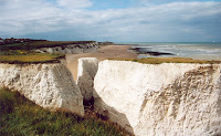 Here we left the English Channel behind and took on the North Sea which we will follow all the way to John o’Groats. We were on the top of chalk cliffs with a natural arch and stacks, and an old building that could have been a fort in years gone past. Is it Roman? Or medieval? Or Napoleonic? We had no idea because there was no information board about it at all.
  On the map it is called ‘Neptune’s Tower’, and it is sited in the corner of a golf course. (A few weeks later, we discovered that it is a folly which was put up by the same 18th century eccentric who built the pseudo castle.)
 We walked westwards down a slope where, at last, we found a seat to stop and have our lunch. We sat there like a pair of old fogeys in the pale sunshine enjoying our fresh butcher’s pies and our fresh baker’s cakes, and idly watching a pair of joggers approach. They were dressed the same, two middle-aged men who were identical twins – and we speculated on what it must be like to have someone else who is exactly the same as yourself, in effect to be two people instead of one. It was so peaceful and so ordinary – we had no idea of the terrible events that were happening at that very moment in New York and Washington!
We carried on past a miniature golf course to Foreness Point where we could see for miles along the North Kent coast. We walked past a number of greens with rows of terraced guesthouses behind, a bit like the green at Littlehampton that I know so well. But somehow there was an air of dilapidation about the whole place. We passed a big indoor bowls complex, and I remembered a recent conversation I had with my sister, Veronica. She and her husband took up bowls a little while ago, and play in competitions all over the South of England. They came to Margate about a year ago, and they were most uncomfortable during their stay. They felt the town was a ‘has-been’ resort, very seedy in character. The streets and guesthouses seemed to be full of illegal immigrants who were kicking their heels not knowing what to do next. Veronica didn’t want to go out after dark, and they were both relieved when they went home. I think it was because we stuck to the coast that we only saw one man fitting that description, standing on the seafront staring out to sea without really looking, and idly kicking at a few small stones.
As we passed a workman’s van, we overheard a snippet of the News that was blaring out. Tony Blair was talking about stamping out terrorism, and we assumed he was going on about Northern Ireland again. We moved out of earshot and forgot about it immediately.
 The sands at Margate are wonderful, soft and golden – it ought to be a ‘golden’ resort. And it used to be! I spent a holiday there in 1959, with my Mum and Dad, three of my five brothers – Michael, David and Topher – and my younger sister Bernadette.
  (Veronica didn’t come because she was preparing for her wedding which took place two months later, and Frank and John were away from home training to be priests.) We had a wonderful time at one of Britain’s premier resorts. Margate had everything going for it in those halcyon days, and the summer weeks were always booked solid by March!
  The golden sands are still there, but covered thickly in seaweed.
There were tractors and lorries on the beach making gallant efforts to clear it away, but the season is all but over for this year – why did they not rid the beach of it earlier? We passed the Lido, completely derelict and silted up. It looked as if it hadn’t been used for years. Then we came round the corner to the harbour, and I didn’t recognise it at all. The long wooden pier which had been decorated with ornate Victorian ironwork, and with a lifeboat station halfway along it, which was the central feature of Margate forty-two years ago, was GONE! I remember walking along it in the evening sun.
  I remember catching a paddle steamer, called ‘The Royal Sovereign’, from the end of it for a sail along the coast and back – I even have the photos I took on that trip.
  I remember seeing the maroons go up from our guesthouse a mile away and running round to it in the vain hope of seeing the lifeboat splash down the steep slope from its shed (it had already been out and back by the time we arrived and was disappointingly bobbing up and down in the water below.) But all we could find was the harbourmaster’s office with a clock tower on it, and even that was tatty.
  In 1978, there was a huge storm on this coast and Margate Pier was washed away. All trace of it has disappeared!
We walked along the harbour wall, but there were only a couple of very small boats stranded on the sand by the tide – by no means a busy fishing harbour, you couldn’t even call it a marina. Then we crossed the road and entered ‘Dreamland’, a permanent fairground. My mother suffered from vertigo, and whenever we visited a funfair as youngsters she would forbid us to go on the ‘Big Wheel’. Anything else was OK, but she couldn’t bear to go on such an ungainly contraption herself and equally couldn’t bear to see any of her precious children hanging up there in the air on a seat that rocks! I was fourteen years old in 1959, and David and Michael were sixteen and eighteen – but it was still forbidden to all of us. (Mind you, we had much longer childhoods in those days – which was all to the good – and didn’t think it unusual to have to obey our parents when we were already teenagers.) I remember her standing near the Ferris wheel in ‘Dreamland’ screaming, “I just can’t bear to look!” and hurrying us away to the penny slot machines.
For years I never thought about it.
My dear mother died in 1985, and four years later my first grandchild, Jamie, was born.
When Jamie was eight, I was chatting to him one day and mentioned that I had never been on a ‘Big Wheel’ in my life.

He was amazed, and offered to take me on one.
We had promised to take him camping in Kent for a weekend because we thought he might be interested in Dover Castle, and Colin said that the Wheel at Margate was reputed to be the biggest in Europe – so that was it, the trip was planned.
When we arrived at the venue and Jamie saw the size of it, he got cold feet.
However, I managed to cajole him on to it, and I had my first ever ride on a Ferris Wheel at the age of fifty-two with my grandson clinging to me so tightly that I thought he would draw blood.
It was a
wonderful experience!
Jamie thought so too –
afterwards, when he was able to boast about how he looked after his terrified Grandma throughout the ride!
Now we were back, and looking for our first ride on a Ferris Wheel on this trek (rule no.11). Last year, when we were walking in the Dymchurch area, we had picked up a leaflet advertising ‘Dreamland’ in Margate and couldn’t find any reference to the Big Wheel; so we suspected it was no longer there. The rooms with the noisy slot machines was going full swing (costs a tad more than a penny these days!) and a few sad figures were working them – not quite Las Vegas. We went outside to find the big rides were not closed, but not exactly open either. There were notices telling us that if we really wanted a ride then we should speak to an attendant who would open it up for us – but there was no one there! It was all rather spooky, it reminded me of a ‘horror’ novel I read once where the murderer stashed the bodies away in a disused fairground. ‘Dreamland’ is quite a large area with lots of roller-coasters etc, but each year people want rides that are more and more ‘exciting’ (or sick-making, depending on which way you look at it), so old-fashioned things like the Ferris Wheel get replaced by bungy chairs and towers that take you up and down at the force of several G! We came across a couple of workmen who were tinkering with one of the rides, and asked them about the Big Wheel. They told us it had been sold to Mexico a couple of years ago!(Score so far: ‘real ale’ pubs - 21 – Ferris wheels - 0 ) !!
 We returned to the seafront. Our next point of interest was the little hotel I had stayed at in 1959. I can remember the exact location of it – a terraced guesthouse facing the sea, the second one along a seafront road in Westbrook, just to the west of Margate. It was very small but fastidiously clean. We were woken at seven with a hot cup of tea, a full cooked breakfast was served at eight, a two course dinner at twelve-thirty and high tea at half past five. We were expected to be punctual for meals but not to stay on the premises during the day, though they did make an exception when my sister was ill (she had a touch of sunstroke and fainted) and they allowed her to stay in bed until dinner time. My room was so small, the double bed I shared with Bernadette took up two-thirds of the space. We had a wash basin with hot and cold water, but the lavatory was down the passage and shared with all the other guests – about fifteen. We had to pay an extra shilling every time we took a bath, so we didn’t bother because the weather was brilliantly hot and we swam in the sea every day. It was another life, we were so much happier and more content in those days!
 As we approached Westbrook we found heaps of sand had been washed up on to the prom, and some ’orrible urchins just out of school (who were wearing their school uniform the ‘modern’ way – no jumper, blazer or tie, shirt hanging out with half the buttons undone and white trainers with their black trousers) were doing ‘wheelies’ on their bikes through them whilst talking codswallop at the tops of their voices. (Why do I find young people so irritating these days? Could it be something to do with spending thirty-five years in the teaching profession?) We managed to bypass them without getting knocked over, and sat on a wall at a safe distance to consume the second half of our lunch.
 Then we climbed some steps to the road to have a look at ‘my’ hotel. ‘Shoddy’ was the word that came to mind – it looked in dire need of a fresh coat of paint and some new net curtains, though the front door seemed smart. It still had a very old notice above the door declaring it to be the ‘Gloucester Hotel’, but it didn’t look as if it is a hotel now. We suspected it is used as ‘Bed & Breakfast’ accommodation for the homeless or, more probably, so-called asylum seekers. (We found out some weeks later that we were right.) But what really surprised us was that the property next door (which had also been a hotel in 1959) is Margate Youth Hostel! We couldn’t get in there this week because they were booked solid with school children; but if we had, I would have been staying next door to the hotel I stayed in forty-two years ago. The hostel looked smarter, it had been painted. The beach below this row of houses, all of which had been small hotels in 1959, was still just as golden; and the row of beach huts was still there. We had hired one for the week we stayed, and just lazed on the beach for seven days – I remember the weather was very hot and we all had a wonderful time!
  We continued along the prom eastwards. We were rather tired by then and looking forward to the end of the walk. When we got to Mildred Bay we thought we were at Westgate-on-Sea, and when we got to Westgate-on Sea we thought we were back in Birchington! (I am sure it was wishful thinking, we were just willing ourselves back at the car.) The road by the shore didn’t look right, according to the map, so we stopped to ask a couple of girls in the First Aid Station for directions.
  Talk about confusion! Why is it that so many people have enormous difficulty reading a simple map? It is a skill I have always found to be straightforward ever since I started looking at maps at the age of about eight, so I cannot understand why other people find it so hard. One of the girls was very keen to be helpful, but she insisted on telling us a route to Birchington inland despite our protestations that we wished to follow the coast as far as possible. She hardly gave the map I proffered a glance, it was obviously double-Dutch to her. When she said, “And then you turn left!” putting out her right hand, I gave up. She had already confirmed that we were only at Westgate-on Sea, so we waited until she had run out of steam, thanked her politely and carried on. A few yards further, and we came across a ‘NO THROUGH ROAD’ notice – we were pleased that they had actually told us that we couldn’t get through if we stayed at the bottom of the cliff, unlike the cliff between Brighton and Peacehaven and the cliff between Folkestone and Dover where we just had to guess.
 We walked along the clifftop to Epple Bay where we descended to beach level again. Since people were coming towards us along the bottom of the cliff, we assumed we could get through to Birchington. The tide was almost in by now, and in one or two places we had to time our walk past an exposed point where we were at risk of getting wet. There were a number of passages going up into the cliffs. Most of them were blocked off, but we came across one where a narrow and steep flight of steps went up into the darkness. Of course, Colin had to go up. He disappeared, I waited, and then the sound of a barking dog came echoing down! I was having visions of him being torn to shreds by the Hound of the Baskervilles, but then he came nonchalantly down the steps once more. He said they led to a rather high-class housing estate, and the barking dog was safely fenced off in a garden. A few yards further on we reached the cutting up to Birchington and the road where we had parked our car earlier that day. Once again we found the toilets to be derelict and sealed, fortunately neither of us had need of them at that moment.
That ended Walk no.31, we shall pick up Walk no.32 next time at the point where the road from Birchington Station meets the seafront by the abandoned toilets. We walked up from the beach to the car. We had a cup of tea from the flask and then started to drive back to the Youth Hostel in Dover. We switched on the car radio and the news came on – we just could not believe what we were hearing. Four civilian domestic aeroplanes in the United States were hijacked earlier today and deliberately crashed! One was thought to be making for Camp David or the White House, but didn’t make it. One was crashed into the Pentagon, where over a hundred workers died. The other two were crashed into the twin towers of the World Trade Centre in New York – the two highest buildings in the world – and each exploded in a fireball. People were seen leaping from windows seventy or more stories up rather than be burnt to a frazzle. Suddenly, both buildings collapsed in on themselves killing over a hundred rescue workers. New York is a heap of rubble! Thousands are dead – it is impossible to estimate.
Has the world gone mad?
 rate do you have to be to jump out of a window seventy floors up?
 Reculver Towers are in the middle of nowhere, despite the fact that there have been buildings on the site for two thousand years. First the Romans built a fort to protect the northern end of the Wantsum Channel, and it ‘matched’ Richborough Fort which had been erected at the southern end. Almost half of the original Roman complex at Reculver has fallen over the cliff, though traces can still be found of the outer wall, the eastern gate and the bath-house. In Saxon times, a monastery was put up within the boundaries of the redundant fort – this was in the wake of St Augustine’s preaching. By medieval times, the monastery had fallen into disuse but the ground was still considered consecrated, so the stone was used to build a typical church of the period.
 We sat amongst the ruins, protected from the wind by the old stone walls, and ate our lunch looking out to sea. We could see some structures in the water about a mile off the coast, and speculated that they were Napoléonic forts similar to the ones in the Solent. We found out later that they were much more recent, they were constructed in the Second World War to house guns for the protection of the Thames Estuary.
 Colin recognised them as A.W.A.C.S., used for airborne radar surveillance, because he worked on systems for them when he was with Plessey. They were flying north, towards the Greater London area. Everyone is very edgy. The City of London was evacuated for a couple of hours yesterday afternoon as a precaution – it is strongly suspected that many more terrorist attacks are planned on the Western World.
 The main problem they have to contend with nowadays is how to stop the towers toppling over the edge of the cliff as it is pounded by the sea underneath, but then erosion has always been a problem here. The medieval church was probably built some distance from the clifftop; now it is teetering on the edge!
 Fortunately, some other visitors arrived with questions, and we were able to quietly make our escape!
 There was a lot of that ugly orange plastic fencing blocking our way and dire notices about the danger. Work was in progress on the collapse, every so often we could see the bucket of a digger stretch out from behind bushes and dump its load over the cliff. They seemed to be taking down all the loose sand from the cliff face, probably to avert another landslide. As soon as we had passed that, the proper path diverted inland because a tiny stream cuts down through the soft cliffs.
  It is a lovely walk through a wood, with an attractive footbridge where we crossed the creek. We were joined by a young family apparently on their way home from school. (“Is it that late already?”)
 We were getting morose, which isn’t fair to Herne Bay. We walked along the harbour wall which is long and very modern. At its end we climbed a little ironwork tower to look at the view. At first we thought it was another Second World War platform we could see about half a mile out to sea, but then we realised that it was directly in line with Herne Bay’s very short pier.
  It looked like the end of a pier, and we gradually realised that that was exactly what it was! What had happened to the middle bit? We retraced our steps along the harbour wall, not many boats there either but more than in Margate’s little harbour.
 Then it collapsed in a storm, and some lunatic set fire to the remainder. By the time they had doused the flames, the few remaining ruins were a safety hazard, so they were removed leaving just the ends half a mile apart. The ghastly building on the shore bit has only been there a short time, and none of the locals like it either.
  Brighton was successful with its bid to restore its West Pier, but that was almost two years ago and work has yet to start. These Victorian piers round our shores were not really built to stand the battering of the sea for ever! We walked on about a hundred yards until we were at the end of the road where we had parked our car earlier in the day.


