Thursday, June 30, 2011

Walk 275 -- Claonaig to Tarbert

Ages:  Colin was 69 years and 53 days.  Rosemary was 66 years and 195 days.
Weather:  Mostly sunny.  Breezy.
Location:  Claonaig to Tarbert.
Distance:  13 miles.
Total distance:  2650 miles.
Terrain:  Roads at first, followed by tracks and then a footpath which was a bit boggy.  Later we came upon an awful clinker road which was quite uncomfortable to walk on.  This turned into a track, then we turned off on a footpath.  We climbed quite high and it was a bit steep in places coming down.
Tide:  Going out.
Rivers:  No.321, Claonaig Water.  No.322, Garbh Allt.
Ferries:  None.
Piers: None.
Kissing gates:  Nos.222 & 223 at Tarbert Castle.
Pubs:  None.
‘Historic Scotland’ properties:  None.
Ferris wheels:  None.
Diversions:  None.
How we got there and back:  We were touring south-west Scotland with our caravan.  The day before yesterday we moved the ’van from Machrihanish to Lochgilphead.  This morning we drove to Tarbert and parked the car near the ferry terminal.  Then we caught a bus to Claonaig and alighted at the road junction with the Carradale road.  We walked uphill for about a mile to the picnic area where we finished the last Walk.
At the end, we walked past the car to the ferry terminal because we wanted to finish the Walk on the slipway.  Then we returned to the car, had our tea and biscuits and returned to Lochgilphead.

We find it difficult to believe that our lovely grand-daughter, Kelly, is 20 years old today!  We see very little of her these days, unfortunately.  Now she is grown up she leads her own life.  Never an academic child, she has recently decided she wants to be a midwife.  So she is working her socks off — funding herself by working in a supermarket — on an ‘Access’ course to gain the qualifications she needs to go to University where initially she will study for a nursing degree.  We are very proud of her.
Before we got going on today’s Walk, we sat at a table in the picnic site where we finished the last Walk to eat our pies.  We weren’t much bothered by midges this time as it was earlier in the day, but there were a few about making a nuisance of themselves.


We came out on to the road, and found a Kintyre Way post telling us we had thirteen miles to walk to Tarbert.  We followed these posts all the way today, and for a change the path did not let us down.

We had good views of the Isle of Arran as we walked down the road towards Claonaig, the weather was clear and we were at our nearest point to the island.  Colin photographed a weathervane which took his fancy, and I concentrated on a beautiful wild orchid on the grass verge.  We still can’t get over the proliferation of wild orchids we have seen on our way round the coast, especially in Scotland.  They seem to be everywhere!
We had good views of the ferry between Claonaig and Arran as we came down the hill.  It is a frequent service, the boats turn round at each end and go straight back.  We watched one load up with about a dozen cars and set off — and it didn’t seem long before another boat was coming in to unload.  We also watched the bus from Tarbert drive down to the ferry terminal, then turn round and come back.  When we got down there, we sat on a bench nearby to eat our sandwiches.
We walked a couple of miles along the road to Skipness, a very quiet road because Skipness is a tiny hamlet and the road is a dead end.  Colin occupied himself photographing oystercatchers and other wading birds on the rocky shore whereas I concentrated on the rocks themselves.  They were twisted into all sorts of shapes, I was sure they were metamorphic.  (Yes!  Just looked it up on the geology map.  The base rock in this area is listed as quartz-mica schist, grit, slate & phyllite—Upper Dalradian.)  I would like to study metamorphic rocks a lot more deeply because they are so complex and interesting — but I haven’t time with everything else I do.
We both photographed some of the ubiquitous wild orchids on the wayside.  And we both photographed Arran, zooming in on the craggy top of the mountains.  The island looked like a giant triceratops resting in the sea!  The sun was shining, the sea was calm and blue, and we were both in buoyant mood — life was good!
Skipness may be a tiny hamlet, but it boasts a shop which sells ice cream!  So we bought a couple and sat on a seat outside to eat them.  Through our optical instruments (binoculars for Colin, small telescope for me because of my visual defect) we could see the remains of Skipness castle, and a ruined chapel.  But we didn’t go round to look at them more closely because time was getting on and we still had the bulk of the Walk to do.
Following the Kintyre Way signposts, we turned up a track.  It was a long steep hill which seemed to go on forever.  Away from the coast we were sheltered from any breeze — so we got very hot with this uphill climb.
The track levelled out a little and we seemed to be following the course of a river for a couple of miles.  But we couldn’t see the water, only hear it, because the undergrowth had grown up so much.  We could see the ruins of a cottage across the river valley, but no one lives up there these days.
Up and up we went through a conifer forest — but it was not closed in and vast swathes had already been felled.  We wondered if they will plant mixed deciduous woodland in its place.
We came to a picnic table, so we sat and ate our apples even though it was a little early for this — got to take the opportunity when it is presented!  We still had good views back towards Arran for we were not yet at the top.  The grass had been mown all round the table to make it a pleasant place for passing hikers to stop, but we were disgusted to find a big pile of dog’s s**t right where we needed to put our feet!  There are always selfish people who spoil things, you can’t blame the dog.
We were on a narrow footpath for the next couple of miles.  It was more uneven and overgrown — in fact we had difficulty finding where it led off from the picnic table.  It was swampy here and there as well, but plastic netting mats had been put down in the worst places which was a help.  The path curved round trees near the top, proceeding up and up as if it was never going to reach the summit.  We were sheltered from any breeze, and got quite hot.
At last we reached the top!  The path opened out, and there was a pleasant breeze — we felt good.  Downhill all the way from now on!  We started to descend.
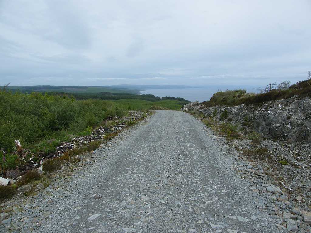
Then the path came out on to an horrid clinker road.  It may have been good for driving vehicles with big tough tyres, but it was dreadfully uncomfortable to walk on even with our pukka walking boots.  We were very disappointed — it seemed as if we were walking through an industrial landscape, not the country walk we had been expecting.  And the Kintyre Way signposts were the wrong way round too.  They had been set with all their arrows pointing for people walking south from Tarbert, not for those, like us, who were walking north to Tarbert.  It wasn’t at all clear which way we had to turn when we came to the clinker road, but we guessed we turned right from the angle of the arrows pointing the way we had come.
This road had been cut through the peat layer and down into the base rock,  It was interesting looking at this geology.  We came to another picnic table after about a mile, and following that the clinker stopped — we were quite relieved.  However it was still a road and a bit stark, not at all like the forest walk the map had seemed to promise.  However it was much kinder to our feet than the clinker!
At least we were going downhill — well mostly.  It was a bit undulating, and we found ourselves getting mildly annoyed at the ‘up’ bits.  We must have been getting tired by then.  We began to get views of Loch Fyne out from Tarbert, that cheered us up.
The road seemed to be meandering about and wandering off in the wrong direction.  Suddenly — so suddenly we almost missed it — we came to a footpath off to the right waymarked with the Kintyre Way sign.  A narrow but good footpath led us steeply downhill……in the right direction!
There was a cairn near the top of this footpath.  A plaque on it revealed that it was built to celebrate the birth of someone’s twin nephews in 2000.  How refreshing to come across something celebrating a birth, instead of the myriad of memorials remembering people who have died!

I looked at the twisty ropey metamorphic rocks again, I do find them fascinating.  They have been through a complex history of billions of years to end up like that.


Gradually the picturesque port of Tarbert revealed itself at the bottom of the hill.
The views were fantastic — not only of Tarbert but all along Loch Fyne and across to the Cowal Peninsula where we shall be on the next Walk.
It was such a panorama we forgot to feel tired.  We both felt really good to be alive!
Further down, the route was not so well marked.  There seemed to be a labyrinth of paths criss-crossing in all directions.  We made towards the general direction of Tarbert each time we came to a division, and generally got it right.  We looked back at the hill we had just come down, and felt quite glad we didn’t have to climb it!
When we were nearly down, we walked through Tarbert castle.  There is hardly any of it left, and what remains was under scaffolding.  So we didn’t bother to look any further, just exited down to the ferry road.
Tarbert looked lovely in the evening light, very pretty!  It is mainly a marina now, and makes its money through tourism rather than fishing.  But a reminder of its past was over a gateway we passed — two whale bones.
We passed our car parked on this road because we wanted to walk to the ferry slipway.  The logistics of actually using the ferry to cross to Portavadie on the Cowal Peninsula didn’t bear thinking about, so we didn’t.  (We would have had to ride on it both ways because its an awful long way round by road.)  Anyway, the last ferry of the day had already left by the time we got there.  Some people were using the slipway to tow a boat out of the water.

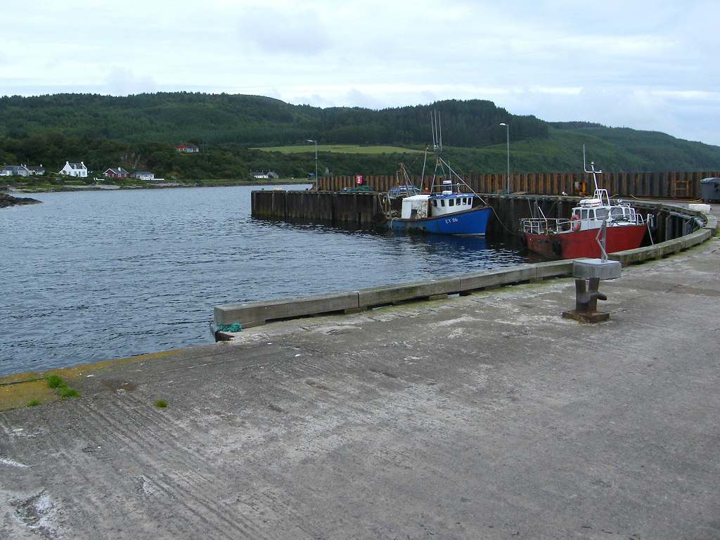
That ended Walk no.275, we shall pick up Walk no.276 next time on the other side of Loch Fyne on the ferry slipway in Portavadie.  (We plan to pretend we took the ferry, once again!)  It was twenty to nine, so the Walk had taken us seven and a half hours.  We returned to the car, and moved it a little way along the road to a place where we had a nice view, before we had our tea and biscuits.  Then we returned to our caravan in Lochgilphead.
The next day we towed our caravan to Dunoon, a lovely route alongside Loch Eck.  Scotland was at its best in the sunshine!

Monday, June 27, 2011

Walk 274 -- Carradale to Claonaig

Ages:  Colin was 69 years and 50 days.  Rosemary was 66 years and 192 days.
Weather:  Cloudy and breezy.  Occasional glimpses of the sun and occasional light drizzle.
Location:  Carradale to Claonaig.
Distance:  14 miles.
Total distance:  2637 miles.
Terrain:  First three miles on forest tracks and paths, but mostly road which was fairly quiet. Undulating.
Tide:  Going out.
Rivers:  No.320, Crossaig Burn.
Ferries:  None.
Piers: None.
Kissing gates:  None.
Pubs:  None.
‘Historic Scotland’ properties:  None.
Ferris wheels:  None.
Diversions:  None.
How we got there and back:  We were staying in our caravan in Machrihanish.  This morning we drove to Carradale with Colin’s bike in the back of the car.  He left me there to doodle away a couple of hours while he drove on to Claonaig, parked the car and cycled back.  He locked the bike to some railings by the public conveniences.
At the end, we arrived at the car.  We moved the vehicle to a breezier place before consuming tea and biscuits because of the midges.  We returned to Carradale to pick up the bike, and thence back to our caravan.

There is no public transport between Claonaig and Carradale, it is too far away from anywhere to book a taxi and there is not enough traffic to successfully thumb a lift.  So Colin put his bike in the back of the car, and we drove to Carradale where he left me at the harbour.  Fortunately I had good views to look at, a bench to sit on and a toilet block nearby — as it took him two and a half hours to drive to Claonaig and cycle back.  It was a bit hilly!
I had a good look round this small harbour while I was waiting.  It is still a working fishing port, though in a small way.  A couple of fishing boats were moored in the harbour.  I came across two plaques which illustrate just how dangerous the fishing profession can be.  One was in memory of four young men, James Russell, William Martindale, Stewart Campbell and Dugald John Campbell, who died when their trawler sank off the Isle of Arran in 1990.  The other was a new plaque put up only three months ago by descendants of the McIntosh family who lost four members, a father, his two sons and a nephew, in a storm in March 1911.  When we eat our fishy meals — I love fish — we should appreciate more the courage of the men who caught them for us.
There is also a shop on the quay, it looks like an old shed but it is the village shop and much used by the locals.  The bus delivers daily newspapers on its first call of the morning.
When Colin arrived at last — thoroughly exhausted because the road had been much more hilly than he had been expecting — we sat on the bench to eat our pies in order to give him time to get his breath back.  Then we started the Walk.
We marched back up the road and turned on to a forest track.  We thought we were very brave to trust ourselves to the Kintyre Way again after being let down by it twice before.  But we were in for a surprise, it was a good path and well way-marked for its first three miles through the forest.  It went uphill for a long way.  I found it hard going, and Colin wondered whether he would make it after using up most of his energy on the cycle ride.
It twisted and turned a bit further up to get to the very top of the hill.  It was a little swampy, but wooden steps had been put in to help us.
We had marvellous views of Arran which was very near, or so it seemed.  Colin amused himself by taking pictures of a green beetle on the swamp.  Then we noticed two of these beetles mating on the pathway……  I think its time we moved on!
We descended on a forest road which was a wide gravel track.  Colin was OK then, going downhill.  We were both very tired, I felt as if I was falling asleep walking along!  So we blindly followed this road wherever it went, and didn’t notice the Kintyre Way path turning off on a more direct route near the bottom of the hill.  By the time we woke up to this fact it wasn’t worth going back, so we did an extra loop which was annoying.  We came out on to the road at a picnic site, so we sat there and ate our sarnies — for as long as the midges would let us!
The next eleven miles of the Walk was along a road.  It was a narrow lane with passing places.  There was not much traffic, but it was a nuisance when it did come because we never seemed to be by a grass verge or at a passing place when it caught up with us, and we usually ended up having to jump in the ditch!  As usual these days, the vehicles tear along much too fast taking no notice of the road signs which are obscured by rampant vegetation anyway.
We came to the hamlet of Grogport (yes, really!) where we sat on a wall to eat our apples.  There was a short beach there, the only one we saw all day.  We trudged on.
Colin seemed particularly cheesed off today — we both hate it when we have to set up a Walk by him cycling.  “Remind me of the good bits of the Kintyre Peninsula!” he said, just a little sarcastically.  So I reminded him of the glorious Machrihanish Beach and the otter we saw near Muasdale.
The Mull of Kintyre (before it started to rain), the beautiful wild orchids we have seen all over the place including today, and the wonderful views of the Isle of Arran we were enjoying at that very moment!  He was silent.  But it really was a bit dull trudging up and down hills on that road.
We passed a milestone telling us we were 22 miles from Campbeltown.
As we approached Crossaig, we met a lady walking her dogs.  “You can fill your water bottles at the tap if you wish!” she said, “It’s OK!”  We hadn’t noticed there was a tap until then, but we were quite glad of the permission because our supplies were running low with the warm muggy weather.  A notice (Cour Estates) by the tap said it was for residents only, otherwise the system would run short.  We surmised they didn’t want huge motorhomes filling up (much of the passing traffic on this narrow lane was motorhomes) but a couple of small bottles-worth from hikers like ourselves wouldn’t make much difference.
We passed a milestone telling us we were 23 miles from Campbeltown.  Eh?  Surely we’ve walked more than a single mile since the last milepost!  Yes, we were both very tired.
We crossed a stream and trudged on, trying to enjoy the beautiful wild flowers and the wonderful views of Arran to our right.  But we were really glad to get to the end of the Walk.  Colin had parked the car in a little clearing, one mile short of where we had previously planned.  We were glad of that today, though not on our next Walk!
That ended Walk no.274, we shall pick up Walk no.275 next time at the forest clearing one mile south of Claonaig.  It was seven o’clock, so the Walk had taken us seven hours.  The clearing was riddled with midges, it was that time of day.  So we moved the car to a breezier place back along the road before consuming our tea and biscuits.  We then returned to Carradale to pick up the bike, and thence back to our caravan in Machrihanish.
The next day we moved the caravan back to a site in Lochgilphead, and took a couple of days off to rest and recover our spirits.