Ages: Colin was 79 years and 42 days. Rosemary was 76 years and 184
days.
Weather: Mostly sunny with quite a cool breeze.
Location: Merrion to Bosherston Lily Ponds.
Distance:
7 miles.
Total distance: 3975 miles.
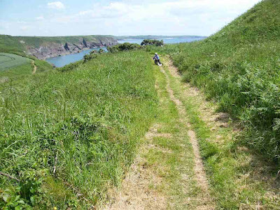
Terrain: The
first two miles were along a concrete road across the ranges. Mostly
a clifftop track, sometimes stony and sometimes grassy. Slightly
undulating but there was one deep cleft. We also descended the
cliffs to a chapel. Deep sand beach at the end.
Tide: In, going out.
Rivers: None.
Ferries:
None.
Piers:
None.
Kissing
gates: None.
Pubs:
None.
‘Cadw’
properties: None.
Ferris
wheels: None.
Diversions:
None.
How we
got there and back: We were caravanning at Freshwater East. This
morning we drove to Bosherston and parked in the National Trust car
park. We caught the bus to Merrion and were dropped off at the gate
which leads across the ranges. This gate was open today, and the red
flag had been taken down.
At the
end we came to a bench overlooking Broad Haven South beach. It is
situated at the end of Bosherston Lily Ponds. After a rest, we
walked alongside one of the lily ponds back to the car park. Then we
drove back to our caravan at Freshwater East.
My injured thumb is
still a little bit sore, but it is nearly back to normal now. The
gate to the ranges was open, so we were able to do today's planned
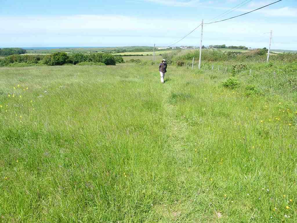
Walk. The first couple of miles were boring, we walked an almost
straight concrete road leading from the crossroads, where we got off
the bus, to the sea.
About halfway along we came to another
crossroads where range traffic could go across. A young soldier was
standing there all day making sure that the general public didn't
stray off course. What a job! We felt sorry for him. We heard
skylarks as we walked down, lots of them. And we noted a few bent
trees and bushes — it must get very windy there at times. On arrival at the
car park at the top of the cliffs, we veered a little to the right to
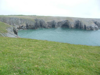
look at the natural rock arch called “The Green Bridge of Wales”.
It is quite spectacular. Next to it is a rock stack which was
covered in squawking guillemots — we had heard them from well down
the road as we were approaching. While we were
watching them, I happened to notice that a couple of cyclists had
lifted their bikes over a gate to the west and were cycling off over
Castlemartin Ranges! Now, I was under the impression that those
ranges are permanently out of bounds because of all the ordnance that
has been left there. I walked over to the gate to read the notices
which were the usual “Keep Out” variety, but the one on the gate
talked about “permit holders”. Then two hikers came up and
climbed over the padlocked gate. So I asked them, and they said you
could get a permit by filling in a form online and handing it in to
the soldier we had passed further back at the crossroads. I was
miffed at this because I knew nothing about it. We had discounted
Castlemartin Ranges as a dead loss and did that last Walk on a deadly
inland route round them. Ah well, it's done now.
We continued
eastwards along the track, passing more guillemots squabbling on
stack rocks on the way. We saw lots of wild flowers, especially
lovely were the wild orchids we found.
The track went in a much
straighter line than the actual coast, and at times seemed to veer
away from it. But we discovered, when we went to look for a suitable
bush to “water”, that there wasn't really any other path, and
that it was very difficult trying to walk over rough ground. So we
stuck to the track. After passing
Bullslaughter Bay — what a lovely name! — the track turned
a corner in order to follow the coast. It divided into two — the
shorter one went through a deep dip and the longer one went through a
shallower dip. We chose the longer one. We looked around for
somewhere to eat our lunch. Colin chose some rocks next to an old
World War II pill-box. It was perfect! We were out of the wind and
had a lovely view back across Bullslaughter Bay. We hoofed on. It
was a bit boring because we continued to follow the track a little
bit inland from the cliff edge. But at least there were no clefts!
We passed the occasional rusty tank, just to remind us we were on
Army land. Eventually we came
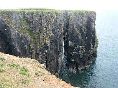
to some spectacular inlets, one of which is called “Huntsman's
Leap”. The story goes that a huntsman was being chased along the
clifftop by some pirates. In desperation he leapt, on his horse,
across the narrow cutting. Had the horse missed, they both would
have plunged to their deaths on the rocks below. They made it safely
across, but then the huntsman looked back at what he had just done
and died of shock! At last we came to
the car park at St Govan's. The tiny chapel in the cleft of the
cliff has intrigued me since the 1970s when I first discovered it. A
few years ago I wrote a poem about the story in the form of a
villanelle. I entered it into our local U3A Welsh group's
Eisteddfod, but it didn't win me the Bard's Chair! However, here it
is:
The Chapel in the Cliff
Where to hide ? Where to hide ? Just cliffs and
sea !
The pirates tried to kidnap me . Oh God !
A fissure opens up ! God is with me !
Govan is my name . From across the sea
To visit Wales to preach, this path I trod .
Where to hide ? Where to hide ? Just cliffs and
sea !
A ransom they will ask, to release me .
I am a holy monk, a man of God !
A fissure opens up ! God is with me !
Rocks close above my head . They cannot see
Nor know the fear which is beneath the sod .
Where to hide ? Where to hide ? Just cliffs and
sea !
They’ve gone away, back to sea . I am free !
The fissure opens up . Thank you, my God !
The fissure opens up ! God is with me !
But a coward I’ve been ! Shame engulfs me .
I’ll stay, I’ll build a chapel to my God.
Where to hide ? Where to hide ? Just cliffs and
sea !
A fissure opens up ! God is with me !
We went
down the steps into the chapel which is
empty. We went out the other side where we found some
rocks to sit on and eat the second half of our lunches. There were
lots of people coming and going, most with a mobile phone in hand as
people do these days. I carefully counted the steps coming down, and
again when we went up. Legend has it that it is never the same
coming down as it is going up, and I wanted to disprove this ancient
story. I was so careful
to count correctly. I made it 76 steps coming down, and 77 going up
— Aaaaaaaaaahh!
As I emerged, a man
standing there with an ice cream in his hand said, “That looks
hard! But the ice creams are good, I can recommend them!”
What a good idea! So we went over and bought one each.
We were feeling
tired by then, and we are getting old. We intended missing out on
walking round St Govan's Head, instead cutting straight across. But
the mistake we made was not looking at the map, we thought it would
be obvious. We followed a tarmac track from the car park, but that
took us to the end of St Govan's Head and we didn't realise this
until we got there. So we walked back along the other side, round
what looked like a tumulus, and were presented with a deep cleft. Oh
no! We hadn't been expecting one of those today. It didn't look
too bad, but we found a few tricky bits going down. Luckily I had my
poles, and Colin's steady hand to help me. Climbing up the other
side was steep with no steps, but we managed it okay. We joined the
track we should have been on, a track which came out of a different
corner of St Govan's car park and which didn't have a cleft to
negotiate.
We climbed over
another hill and there we exited the ranges through a gate. We were
relieved that they were now behind us. We were in Broad Haven South
car park.
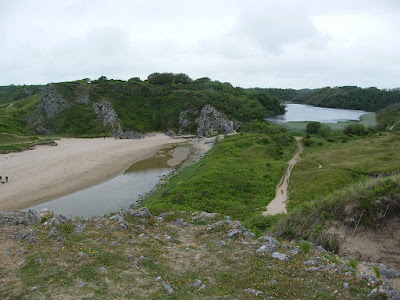
We soon found a very sandy path leading down to the beach.
Part way down was a path leading off through the bushes to the left.
A notice said “START” with an arrow. Start
what? Colin thought it might be our path leading behind the
dunes to the lily ponds, but I thought it went off too high up. So
we continued down and found there were no other paths leading off
before we hit the beach. For once I should have listened to my
better half!
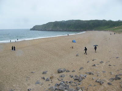
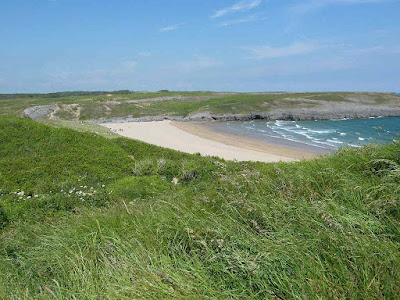
The beach was deep
soft sand of a lovely golden colour — a beautiful beach but
terrible for walking on. So we went down to the water's edge and
walked along there where the wet sand was a tad firmer. On reaching
the other side, we walked back up the beach on wet sand next to a
pool. We came to a bench which overlooked the beach at the end of
the lily ponds.
That ended Walk
no.392, we shall pick up Walk no.393 next time at the end of
Bosherston Lily Ponds overlooking Broad Haven South beach. It was
ten to four, so the Walk had taken us six and a half hours. After
resting on the bench for a while, we walked alongside one of the lily
ponds back to the car park. Then we drove back to our caravan at
Freshwater East.