Ages: Colin was 71 years and 129 days. Rosemary was 68 years and 271 days.
Weather: Threatening sky at first, and a cold
wind. One sharp shower just to annoy
us! Then mostly sunny. The wind dropped and it got much warmer.
Location: Four Mile Bridge to Rhosneigr.
Distance: 8 miles.
Total distance: 3553 miles.
Terrain: Grassy paths around the estuary. Lovely beaches, especially Traeth Cwmyran beach which was fantastic to walk along. Grassy path across the dunes. Pavement through town. Mostly flat.
Tide: Out.
Rivers: No.421, Llyn Cerrig-bâch outlet. No.422, Afon Crygyll.
Ferries: None.
Piers: None.
Kissing gates: Nos.622 to 641 along the estuary path (20 in all!)
Pubs: None.
‘Cadw’ properties: None.
Ferris wheels: None.
Diversions: None.
How we got there and back: We were staying in our caravan on a remote farm in the middle of Anglesey. This morning we drove to Rhosneigr station where we caught a train to Valley. There we walked down the road to Four Mile Bridge.
At the end we finished in a car park amongst the dunes. It was twenty-five past three, so the Walk had taken us 6 hours. We walked about a mile inland to Rhosneigr station where our car was parked, mostly alongside a lake so it was very pleasant. There we had our tea and chocolate biscuits before driving back to our caravan.
We immediately took down the awning — in perfect weather of sunshine and no wind — and packed it away, dry, into the car. The next morning it had turned wet and windy again, so we were very pleased we had done that. We packed up the caravan and returned home to Malvern.
 A little way across the bridge we turned off the road and followed a
track. We then walked across fields
which were a bit rocky, in fact we passed an old quarry. We sat on a rock to eat our pies, and while
we were there we were passed by a group of teenage girl hikers, different girls
from yesterday’s group.
A little way across the bridge we turned off the road and followed a
track. We then walked across fields
which were a bit rocky, in fact we passed an old quarry. We sat on a rock to eat our pies, and while
we were there we were passed by a group of teenage girl hikers, different girls
from yesterday’s group.
 We met a friendly horse and gave him (or her) a pat. The path was a bit undulating, and when we
rose up high we could still see Four
Mile Bridge
if we looked behind. We came to a
footbridge over an inlet where a notice told us it was “Valley Tidal
Doors”. We assumed the doors were to
stop seawater getting to the marshes behind us.
We met a friendly horse and gave him (or her) a pat. The path was a bit undulating, and when we
rose up high we could still see Four
Mile Bridge
if we looked behind. We came to a
footbridge over an inlet where a notice told us it was “Valley Tidal
Doors”. We assumed the doors were to
stop seawater getting to the marshes behind us.
 We emerged on to a lane where we met a woman with her two children in a
car. She asked us if we had seen two
groups of girls. We replied that we had
been passed by one group but hadn’t seen the other. She explained that she was their teacher, and
she was looking for them to make sure they were OK.
We emerged on to a lane where we met a woman with her two children in a
car. She asked us if we had seen two
groups of girls. We replied that we had
been passed by one group but hadn’t seen the other. She explained that she was their teacher, and
she was looking for them to make sure they were OK.
 A bit further on we realised we had missed a
turning, so we retraced our steps. We
found the blue logo and arrow were so buried in a hedge we hadn’t seen them as
we passed by. Next we were in a field
with lots of horses trotting round us.
They seemed to be friendly, but they were a bit off-putting as they were
so big.
A bit further on we realised we had missed a
turning, so we retraced our steps. We
found the blue logo and arrow were so buried in a hedge we hadn’t seen them as
we passed by. Next we were in a field
with lots of horses trotting round us.
They seemed to be friendly, but they were a bit off-putting as they were
so big.
 The path led us down to the
Anglesey side of the Cymyran
Strait which we followed
for several miles.
The path led us down to the
Anglesey side of the Cymyran
Strait which we followed
for several miles.
 My camera then packed up! The
batteries were low, so I changed them for a set of charged-up batteries. I took a couple more shots, and these
batteries read low as well. It’s time I
bought myself a new camera. I had to use
Colin’s camera for the rest of the Walk.
My camera then packed up! The
batteries were low, so I changed them for a set of charged-up batteries. I took a couple more shots, and these
batteries read low as well. It’s time I
bought myself a new camera. I had to use
Colin’s camera for the rest of the Walk.
We met the teacher again, walking towards us on the footpath with her two children. She’d spoken to the group who were ahead of us and they were all right. She could see the group who were behind us and she was walking to meet them. We had quite a long conversation with her. She told us that there were four groups walking towards each other yesterday and they had all spent the night in a bunkhouse in Rhoscolyn. Today the groups were walking away from each other. We told her about our coastal venture and how far we had got — she was impressed.
We walked on, and soon it started raining quite heavily. I just put my kag on because I had assessed the sky and realised it would only be a shower, though a heavy one. Colin insisted on putting on his kag, overtrousers, the lot! “I’ve been caught out before!” and other such exclamations exploded from his lips when I tried to reason with him — so I left him to it. It took him ages, by which time the shower was over! The sun came out, it got quite hot and we had no more rain all day. It was a long time before Colin could be persuaded to remove his wet-weather gear — obstinate, or what? Meanwhile the teacher came running back with her two children, she’d left their coats in the car. She’d spoken to the other group of girls and was now satisfied that they were all OK.

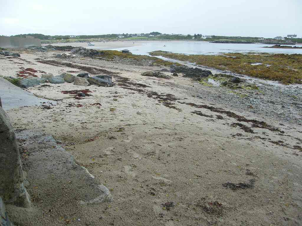
 We came to another inlet. There
was what looked like a narrow concrete causeway across it which would have
saved us about a mile of walking. It
looked as if there was a gravel path along the middle between the seaweed, so
we went down to the shore and started to carefully pick our way across. It got more and more difficult, so Colin went
on to look at the end. It was washed
away there — we would be stepping on stones but they were under water, skewed
and slippery. It was not worth the risk
so we turned back and walked the mile round.
We came to another inlet. There
was what looked like a narrow concrete causeway across it which would have
saved us about a mile of walking. It
looked as if there was a gravel path along the middle between the seaweed, so
we went down to the shore and started to carefully pick our way across. It got more and more difficult, so Colin went
on to look at the end. It was washed
away there — we would be stepping on stones but they were under water, skewed
and slippery. It was not worth the risk
so we turned back and walked the mile round.
 The actual path was narrow and up on a bank, but we found there was a
kind of road round three-quarters of the inlet — it was hard-packed enough to
walk on anyway, and much easier. Coming
back the other side we saw the second group of girls emerge from the
undergrowth behind us. They sat on a
wall to eat their lunches, so they never did catch us up. We were up in the fields by then anyway,
behind hedges. When we reached the other
end of the concrete “causeway” Colin went down to photograph it where it was
broken. Looking at the close-up pictures
later I realised I never could have crossed it safely, so we had made the right
decision to turn back.
The actual path was narrow and up on a bank, but we found there was a
kind of road round three-quarters of the inlet — it was hard-packed enough to
walk on anyway, and much easier. Coming
back the other side we saw the second group of girls emerge from the
undergrowth behind us. They sat on a
wall to eat their lunches, so they never did catch us up. We were up in the fields by then anyway,
behind hedges. When we reached the other
end of the concrete “causeway” Colin went down to photograph it where it was
broken. Looking at the close-up pictures
later I realised I never could have crossed it safely, so we had made the right
decision to turn back.
 I sat in the sun
on a wall post while he did this. It was
so lovely to be out on a brilliant day in such a lovely place!
I sat in the sun
on a wall post while he did this. It was
so lovely to be out on a brilliant day in such a lovely place!
 From there the path led zigzag-like through fields. We could see a wide expanse of estuary sand
down below and knew we would soon be down there. We could see people walking on it, and Colin
wanted to go down directly from where we were.
I said, “No!” for two reasons:
(1) there was a barbed wire fence and a steep bank to negotiate, and (2)
there was a river down there which needed to be crossed. He moaned and moaned about having to walk “all the way inland” to the buildings
(it was about 200 yards!) to where we could cross the river on a footbridge. He never learns that 95% of the shortcuts we
have attempted to take have ended in disaster!
From there the path led zigzag-like through fields. We could see a wide expanse of estuary sand
down below and knew we would soon be down there. We could see people walking on it, and Colin
wanted to go down directly from where we were.
I said, “No!” for two reasons:
(1) there was a barbed wire fence and a steep bank to negotiate, and (2)
there was a river down there which needed to be crossed. He moaned and moaned about having to walk “all the way inland” to the buildings
(it was about 200 yards!) to where we could cross the river on a footbridge. He never learns that 95% of the shortcuts we
have attempted to take have ended in disaster!
 We saw the big propeller plane, which dropped parachutists yesterday,
about to take off. There were no
parachutists today (was it because it was Saturday?) nor jets, thank goodness,
because they are so LOUD and we were now right by the airfield.
We saw the big propeller plane, which dropped parachutists yesterday,
about to take off. There were no
parachutists today (was it because it was Saturday?) nor jets, thank goodness,
because they are so LOUD and we were now right by the airfield.
 But there was a lot of helicopter
activity. Prince William has only
recently moved on after seven years with RAF Search & Rescue here. We would hate to live in this area, the noise
is worse than Farnborough!
But there was a lot of helicopter
activity. Prince William has only
recently moved on after seven years with RAF Search & Rescue here. We would hate to live in this area, the noise
is worse than Farnborough!
 We came to a car park where we were advised not to loiter! A blue arrow had led us into the car park but
didn’t show us which way to go to get out of it. We tried two different narrow paths, but soon
realised we were wrong both times.
We came to a car park where we were advised not to loiter! A blue arrow had led us into the car park but
didn’t show us which way to go to get out of it. We tried two different narrow paths, but soon
realised we were wrong both times.

Everywhere seemed to be overgrown, but the wild flowers amongst the weeds and thorns were lovely.
 We got out the map, and
concluded that a track running parallel to the airfield perimeter track must be
the right way although there was no blue arrow nor logo telling us so. We passed another “NO LOITERING” notice, so we loitered but not with intent because
we hadn’t got a tent (sorry!)
We got out the map, and
concluded that a track running parallel to the airfield perimeter track must be
the right way although there was no blue arrow nor logo telling us so. We passed another “NO LOITERING” notice, so we loitered but not with intent because
we hadn’t got a tent (sorry!)
 It was the correct path, it led across the
dunes to the estuary sands where we wanted to be.
It was the correct path, it led across the
dunes to the estuary sands where we wanted to be.
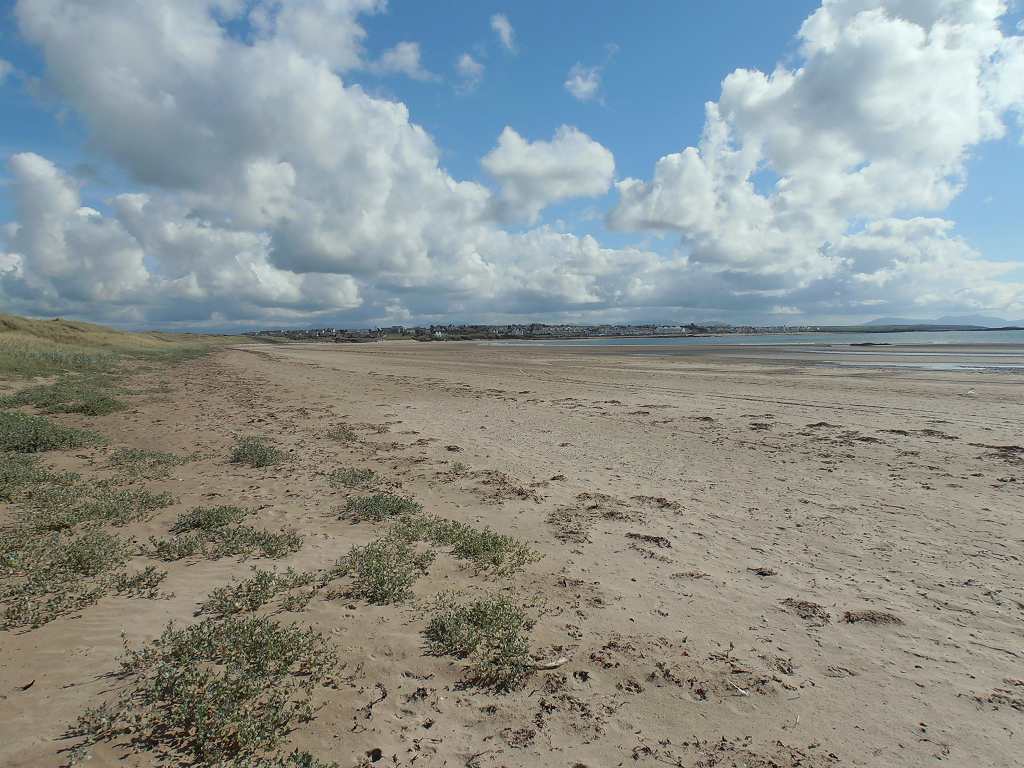
It was lovely to be out on that gorgeous sand! We sat on a bank to eat our sarnies. We carried on through a gap to the real beach.
 Across
the entrance to the Cymyran Strait we could see a sandbank which was a corner of Holy Island where we were yesterday. On the other side of the bank was Silver Bay
where we had sat on a rock so miserably in the rain eating our apples. I expect it was lovely over there today, it
was absolutely
glorious where we were today!
Across
the entrance to the Cymyran Strait we could see a sandbank which was a corner of Holy Island where we were yesterday. On the other side of the bank was Silver Bay
where we had sat on a rock so miserably in the rain eating our apples. I expect it was lovely over there today, it
was absolutely
glorious where we were today!
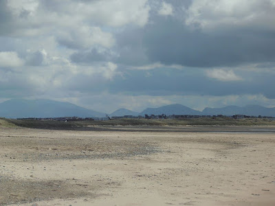 There was a wide expanse of sand, and we could see Snowdonia ahead
looking like smoky mountains.
There was a wide expanse of sand, and we could see Snowdonia ahead
looking like smoky mountains.
 It was two miles along this wonderful beach to Rhosneigr, but…..just
before the town is a river which is not visible until you get right up to
it. We knew about it because it was
marked on the map, and we had been warned about it by a hiking couple we met on
the train this morning.
It was two miles along this wonderful beach to Rhosneigr, but…..just
before the town is a river which is not visible until you get right up to
it. We knew about it because it was
marked on the map, and we had been warned about it by a hiking couple we met on
the train this morning.
 It is too deep
to wade, and it winds back along the beach next to the dunes. They had been caught out, thinking they could
just step off the beach into Rhosneigr, but had to retrace their steps a long
way to get on to the path leading to a footbridge behind the dunes.
It is too deep
to wade, and it winds back along the beach next to the dunes. They had been caught out, thinking they could
just step off the beach into Rhosneigr, but had to retrace their steps a long
way to get on to the path leading to a footbridge behind the dunes.
 We knew we had to take a path off the beach
into the dunes after one mile or so, but there were several paths and we
weren’t sure which one to take.
Eventually we came to one with the blue arrow and logo — this time the
Wales Coast Path signage didn’t let us down!
We knew we had to take a path off the beach
into the dunes after one mile or so, but there were several paths and we
weren’t sure which one to take.
Eventually we came to one with the blue arrow and logo — this time the
Wales Coast Path signage didn’t let us down!
 It was a bit hot
away from the breeze on the beach, and we began to peel off layers. A helicopter on the adjacent airfield (Yes,
it was still with us!) was doing hovering exercises. The noise was a bit of a pain, it rather
spoiled the pleasantness of the place. The
dune path was boring at first, no view, but at least it was grassy rather than
loose sand which makes walking so difficult.
It was a bit hot
away from the breeze on the beach, and we began to peel off layers. A helicopter on the adjacent airfield (Yes,
it was still with us!) was doing hovering exercises. The noise was a bit of a pain, it rather
spoiled the pleasantness of the place. The
dune path was boring at first, no view, but at least it was grassy rather than
loose sand which makes walking so difficult.

 Then we went up high above a bend in the river and we saw how impossible
it would have been if we’d continued along the beach — we had been
tempted! The path led down to a
footbridge over the river, then up into town.
Then we went up high above a bend in the river and we saw how impossible
it would have been if we’d continued along the beach — we had been
tempted! The path led down to a
footbridge over the river, then up into town.
We passed a group of people standing by the railings looking along the beach. “There they are!” shouted one of them, pointing. In the distance, walking blindly towards the river was one of the groups of teenage girls. And there, in the town, were their parents waiting to take them home after their two-day trek. We hadn’t the heart to tell them about the river, which they hadn’t noticed because it was directly below them partly shielded by the wall they were standing on. We often wonder how the girls coped when they reached it — so near yet so far! They should have looked more closely at their maps.
 We met a lady
pushing her dog along in a pushchair!
She told us the dog was old and had recently been ill, so that was the
only way she could take it for a walk.
We bought ice creams and sat on seats at the end of town overlooking the
next beach to eat them.
We met a lady
pushing her dog along in a pushchair!
She told us the dog was old and had recently been ill, so that was the
only way she could take it for a walk.
We bought ice creams and sat on seats at the end of town overlooking the
next beach to eat them.
 We then walked
along this gorgeous beach to the car park where we intended ending this Walk. In fact we overshot it a little, we couldn’t
see it from the beach and went up an overgrown path through the dunes to find
we’d already passed it.
We then walked
along this gorgeous beach to the car park where we intended ending this Walk. In fact we overshot it a little, we couldn’t
see it from the beach and went up an overgrown path through the dunes to find
we’d already passed it.
 Colin took his
cap off and found a HUGE spider on it! Good
job neither of us are arachnophobics.
Colin took his
cap off and found a HUGE spider on it! Good
job neither of us are arachnophobics.

That ended Walk no.344, we shall pick up Walk no.345 next time at the dune car park about a mile out of Rhosneigr. It was twenty-five past three, so the Walk had taken us 6 hours. We used the loos and ate our apples. Then we walked about a mile inland to Rhosneigr station where our car was parked, mostly alongside a lake so it was very pleasant. There we had our tea and chocolate biscuits before driving back to our caravan.
We immediately took down the awning — in perfect weather of sunshine and no wind — and packed it away, dry, into the car. The next morning it had turned wet and windy again, so we were very pleased we had done that. We packed up the caravan and returned home to Malvern.
Location: Four Mile Bridge to Rhosneigr.
Distance: 8 miles.
Total distance: 3553 miles.
Terrain: Grassy paths around the estuary. Lovely beaches, especially Traeth Cwmyran beach which was fantastic to walk along. Grassy path across the dunes. Pavement through town. Mostly flat.
Tide: Out.
Rivers: No.421, Llyn Cerrig-bâch outlet. No.422, Afon Crygyll.
Ferries: None.
Piers: None.
Kissing gates: Nos.622 to 641 along the estuary path (20 in all!)
Pubs: None.
‘Cadw’ properties: None.
Ferris wheels: None.
Diversions: None.
How we got there and back: We were staying in our caravan on a remote farm in the middle of Anglesey. This morning we drove to Rhosneigr station where we caught a train to Valley. There we walked down the road to Four Mile Bridge.
At the end we finished in a car park amongst the dunes. It was twenty-five past three, so the Walk had taken us 6 hours. We walked about a mile inland to Rhosneigr station where our car was parked, mostly alongside a lake so it was very pleasant. There we had our tea and chocolate biscuits before driving back to our caravan.
We immediately took down the awning — in perfect weather of sunshine and no wind — and packed it away, dry, into the car. The next morning it had turned wet and windy again, so we were very pleased we had done that. We packed up the caravan and returned home to Malvern.


We met the teacher again, walking towards us on the footpath with her two children. She’d spoken to the group who were ahead of us and they were all right. She could see the group who were behind us and she was walking to meet them. We had quite a long conversation with her. She told us that there were four groups walking towards each other yesterday and they had all spent the night in a bunkhouse in Rhoscolyn. Today the groups were walking away from each other. We told her about our coastal venture and how far we had got — she was impressed.
We walked on, and soon it started raining quite heavily. I just put my kag on because I had assessed the sky and realised it would only be a shower, though a heavy one. Colin insisted on putting on his kag, overtrousers, the lot! “I’ve been caught out before!” and other such exclamations exploded from his lips when I tried to reason with him — so I left him to it. It took him ages, by which time the shower was over! The sun came out, it got quite hot and we had no more rain all day. It was a long time before Colin could be persuaded to remove his wet-weather gear — obstinate, or what? Meanwhile the teacher came running back with her two children, she’d left their coats in the car. She’d spoken to the other group of girls and was now satisfied that they were all OK.


Everywhere seemed to be overgrown, but the wild flowers amongst the weeds and thorns were lovely.


It was lovely to be out on that gorgeous sand! We sat on a bank to eat our sarnies. We carried on through a gap to the real beach.


We passed a group of people standing by the railings looking along the beach. “There they are!” shouted one of them, pointing. In the distance, walking blindly towards the river was one of the groups of teenage girls. And there, in the town, were their parents waiting to take them home after their two-day trek. We hadn’t the heart to tell them about the river, which they hadn’t noticed because it was directly below them partly shielded by the wall they were standing on. We often wonder how the girls coped when they reached it — so near yet so far! They should have looked more closely at their maps.


That ended Walk no.344, we shall pick up Walk no.345 next time at the dune car park about a mile out of Rhosneigr. It was twenty-five past three, so the Walk had taken us 6 hours. We used the loos and ate our apples. Then we walked about a mile inland to Rhosneigr station where our car was parked, mostly alongside a lake so it was very pleasant. There we had our tea and chocolate biscuits before driving back to our caravan.
We immediately took down the awning — in perfect weather of sunshine and no wind — and packed it away, dry, into the car. The next morning it had turned wet and windy again, so we were very pleased we had done that. We packed up the caravan and returned home to Malvern.