Ages: Colin was 71 years and 124 days. Rosemary was 68 years and 266 days.
Weather: Mostly sunny with a cold breeze. Warm out of the wind. Threatening clouds occasionally, but it stayed
dry!
Location: Porth Swtan to Holyhead.
Distance: 12½ miles.
Total
distance: 3524miles.
Terrain: Mostly grassy cliff paths. Some beach-walking which was lovely! Some marsh, but there were boardwalks and
bridges over the worst parts. Concrete
for 1km over a causeway. Slightly undulating
(not over the causeway!)
Tide: In, going out.
Rivers: No.417, Afon Alaw. No.418, A nameless strait between Anglesey
and Holy Island.
Ferries: None.
Piers: None.
Kissing gates: Nos.576 to 602 spread along the way. (27 in all!)
Pubs: None.
‘Cadw’ properties: None.
Ferris wheels: None.
Diversions: No.76 to our advantage! A brand new footbridge, which was only opened
a couple of months ago, stretched over the River Alaw about half a mile short
of the road bridge, and a brand new footpath had been put in place along the
other bank all the way to Valley where it connected up with the original
path. Boardwalks and narrow causeways
had been put in place over the worst parts of the marshes — it was brilliant! (Apparently it cost the Welsh £1.2million —
well done them!)
How
we got there and back: We were staying
in our caravan on a remote farm in the middle of Anglesey. This morning we drove to Penrhos beach where
we parked in a free car park which had an air of dereliction about it. (Nice beach though!) We walked half a mile up to Morrison’s where
we caught a bus to Rhydwyn. There we
walked over a mile downhill to Porth Swtan.
At the end we
finished the Walk at the car. It was ten
past seven, so the Walk had taken us 8 hours and 10 minutes. We had our tea and chocolate biscuits, then
drove back to our caravan pleased that we had completed the whole Walk in dry
weather.
Today’s Walk began well because there were lots of kissing gates at the
start! But we got lost at least six times — mostly poor signage was to
blame. No sign of the Army today, thank
goodness, we had Porth Swtan to ourselves.
As we walked southwards along the coast, we soon found rocks to sit on and
eat our pies (nice slices of ‘Mediterranean Pie’ today bought in Morrison’s
this morning!)
Just as we were finishing, three elderly hikers in sun hats passed
us. They were walking very slowly so we
soon passed them further on and didn’t see them again. It’s unusual for hikers to be slower than us,
and we wondered how far they got. A
younger couple, well they were middle-aged, passed us, then later we met them
coming back. Ditto a young runner (he
really was young!) We met several people
going the other way — we were not used to such a popular path, usually we are
on our own as soon as we get a hundred yards from a car park.

It was a good path along the top of the low cliffs. We could see Holy Island ahead with ferries
from Ireland sailing into Holyhead Harbour.
We could still see The Skerries if we looked behind. We were observing rocks, birds and flowering
bushes, savouring the seaside scenes. It
was very enjoyable. However, Colin’s
incontinence is worse — he had to skulk behind bushes to change his pad several
times. (We seem to be getting nowhere with the medics despite him
being under the care of the top urologist in the country. It’s not the urologist’s fault that
appointments are cancelled and Colin suffers fobbing off by the system, which
makes him very depressed.)
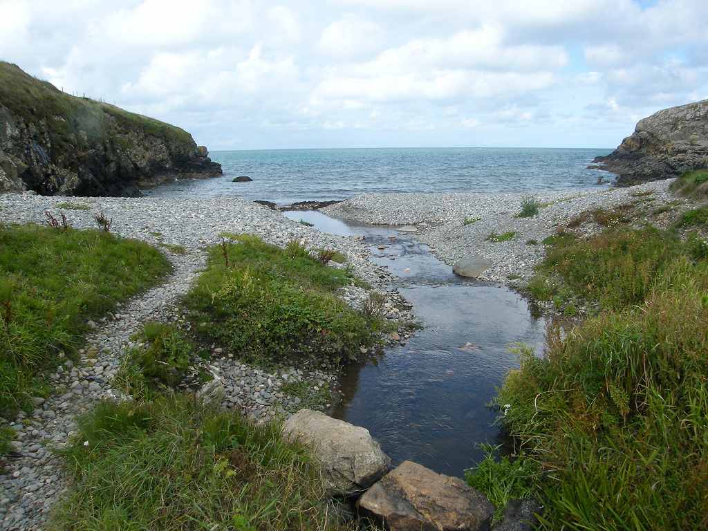
The path led us down to a sandy beach, and it was lovely to walk along the sand in the sunshine. We came off this beach at the further end,
went over a hump, then sat on top of the dunes of another beach to eat our
sarnies.
We walked down to this beach
through a steep channel and had another lovely walk along the sand by the
surf. It made us feel very happy. I videoed the waves so I can watch the sea
when I’m at home and far from the sea.
At the end of this beach we came up through a caravan site and
immediately got lost! A resident
eventually put us right — he said, “I’m used to coastal walkers getting lost
through here!” He must be fed up to the
back teeth, I would be! The path had
been moved since the map was printed.
There was a logo, but it was small and behind us as we came off the
beach. We followed a neat road over a
hump.
Then Colin noticed a stile over a
fence which led into thick brambles — luckily it was not our route. There we met the middle-aged couple on their
way back to Porth Swtan. They were
convinced it was going to rain later — it didn’t.
We went back to the beach by a notice about waves from ferries. Off the beach and over another hump, then we
were able to walk on the beach for over a mile.
But don’t think it was all peaceful and rural — the noise of jets and
helicopters from the nearby RAF base at Valley was quite phenomenal at times,
in fact ear-shattering!
We walked too
far, and found we were on a sandspit at the mouth of the River Alaw. When we realised, we went back to a gate we’d
seen into a field. It did have a logo on
it, but it was small and inconspicuous.
Yesterday we’d been told by a local lady that it was possible to walk across the river near its mouth at low tide,
but there was no way we could walk across it now because the tide was in.
We sat on a mound to eat our apples.
It was a good path across the marshes as we walked inland alongside the
river, scattering sheep, cows and even bulls as we went! The path was well signed — or so we thought
until we came to a dead end. We had
ignored a ladder stile into an adjacent field because the path we were on
seemed to be so good, but it turned out to be an animal track. We backtracked about a hundred yards and
found there was a logo on the ladder stile, but again it was very small and
inconspicuous. The path took us across a
few fields, then we were back alongside the river.

We were not looking forward to the next bit of the Walk. We thought we would have to cross the river
on the road bridge, then walk several miles alongside the busy A road into
Valley. But we didn’t have to because
there was a brand new footbridge over the river about a quarter of a mile
short of the road bridge! It was such a
surprise to come across it because it was not marked on any of our maps. Apparently it has only been open since March
this year. The footbridge, and all the
paths along the other side of the river cost £1.2million!! (We were told this by a local resident whom
we met as we entered Valley.)
The footbridge had been decorated with pictures of maritime scenes, which
we thought was a lovely idea. We crossed
over, then steps led us up on to the other bank. Footpaths, none of which were marked on our
OS map, led us all the way along the river bank to Valley. They were enclosed in high fences so we
couldn’t go wrong.
It was easy walking
along the marsh with boardwalks to help us over the worst bits. In two places we walked along a concrete bar
which kept us out of the mud, and a handrail helped guard against falling off. We met a bewhiskered birdwatcher and had a
long conversation about wildlife.
We reached the end of the new path which connected up with an old
established path above Valley. Another
bearded gent caught us up and was telling us about the coastal path. Apparently he was a volunteer, and he had put
up a lot of the signage logos. (Really,
they should subsequently have asked volunteers like ourselves, who are
strangers to the area, to then follow the signs and check if they have been put
up in useful places.)
We walked between hedges until we reached the beach where we sat on a
rock and ate our chocolate. We planned
to walk all the way along the beach to the causeway because the tide was now
sufficiently out. This was great at first
— we always love walking on beaches — but we came to slippery rocks and the
going got impossible.
We saw an alleyway
which led up into a housing estate, and so we took it thinking we could find a
way back to the beach further on. But we
went wrong in the estate three times
and had to retrace our steps. Eventually
we found an unsigned road — Wales Coastal Path signage seemed to have
completely disappeared — leading to the edge of the estate, across some fields
and down steps to the causeway end.
Suddenly we were there, and we didn’t know quite how it had
happened! (We were very tired by then.)

The causeway leading to Holy Island is
1Km long, and it seemed to take us ages to cross. The Stanley Embankment, as it is called, was
built by Thomas Telford (what a clever chap he was!) in the early 1820s to
extend the road to Holyhead where ferries for Ireland still leave several times a
day. It was a quicker way to reach Holyhead than via the old Four Mile Bridge a little to the south. In the 1840s a railway line was added to the
Stanley Embankment so that trains could also reach the ferry terminal at
Holyhead. A high wall was constructed
between the road and the railway so that trains didn’t startle the horses!

What fascinated us was the water rushing through at a great rate
underneath the middle of the embankment.
The sea is at a different level each side! This is because the tide comes in both ways
round Holy Island, but takes longer one way
then the other. In some places, eg the Isle of Wight, this results in a double high tide in
rivers like the Hamble where we used to take the Sea Scouts camping. But here the Stanley Embankment so restricts
the flow of water, the levels are rarely the same each side and the water
rushes through the narrow opening in the centre.
On Holy Island we turned into a “Coastal Park”
complete with original toll house about to be converted into a tourist tat
shop. We were both pleased to find the
toilets still open, but especially Colin who was able to change his pad and be
comfortable. (His incontinence problem
seems to be getting worse, and it is making him very depressed. Don’t these medics, who keep fobbing him off,
realise what it is like for an active man like he is to be constantly wetting
himself? I wish they would just get on with his treatment!)
The path led through woods where it was almost dark even though the sun
had not yet set. (Actually we were quite
glad it was behind a cloud because we were walking due west and it would have
blinded us if the sky had been clear.)
In the woods we came across a pets’ cemetery. I was surprised the photos came out because
the light levels were so low. We missed
out a small ‘head’ because it was almost a dead end, and we were dead on our
feet by then. We followed a good level path
round a larger peninsula where there were ruined buildings labelled a battery. We then slithered down a channel in a sandy
cliff to the beach — Colin helped me down because it was a bit vertical. The last leg of this Walk was a lovely march
across a sandy beach to the car park where our car was waiting.
That ended Walk no.341,
we shall pick up Walk no.342 on Penrhos
Beach. It was ten past seven, so the Walk had taken
us eight hours ten minutes. We had our
tea and chocolate biscuits, then drove back to our caravan pleased that we had
completed the whole Walk in dry weather.


No comments:
Post a Comment