Weather: Breezy and cold, like a winter’s day! Frequent showers, some heavy.
Location: Cemaes Bay to Porth Swtan.
Distance: 9½ miles.
Total distance: 3511½ miles.
Terrain: Some cliff paths, but the cliffs were lower than yesterday — some almost on the rocky beach. Through woodland near a power station where we got lost. Half a mile of shingle beach — leg-shattering! Roads — winding quiet lanes — for several miles after we sort-of gave up. Undulating.
Tide: Going out.
Rivers: No.415, Afon Wygyr. No.416, Cemlyn Bay.
Ferries: None.
Piers: None.
Kissing gates: Nos.551 to 575 spread along the way. (24 in all!)
Pubs: None.
‘Cadw’ properties: None.
Ferris wheels: None.
Diversions: None.
How we got there and back: We were staying in our caravan on a remote farm in the middle of Anglesey. It was pouring when we woke this morning, and after yesterday’s torrential rain we didn’t feel at all like walking. But the forecast was for it to clear up ‘later’ — it lied! So we messed about a bit, then tardily drove to Porth Swtan where we parked in a free car park. We then walked uphill for over a mile to the village of Rhydwyn where we caught a later-than-planned bus to Cemaes Bay.
At the end we finished the Walk at the car. It was twenty-five past six, so the Walk had taken us 6 hours and 5 minutes. We had our tea and chocolate biscuits, then drove back to our caravan, thoroughly fed up with the weather.
We hadn’t properly dried out from yesterday, and when it was still raining as we woke this morning we really didn’t want to continue the Trek. It was cold too, like winter. The weather forecast said it would clear up later (it didn’t!) so we decided to go, but catch a later bus. We drove to Porth Swtan, but as we entered the car park we were followed by a convoy of Army vehicles — they had come to meet those “sponsored” walkers of yesterday whom they had dropped off in Cemaes Bay earlier to do exactly the same Walk as we were about to do. Now we really do question who pays for all this Army backup, especially as they completely took over the local café so these walkers could have their lunch when they arrived. We couldn’t have bought a cup of tea there even if we’d wanted to! Meanwhile, we had to walk one and a half miles to the nearest bus stop, then pay our own fares to Cemaes Bay.

 We walked round Cemaes
Bay, a pretty fishing
village that was not all pleasure craft. We went under the ‘tramline’ bridge, then
over the top to get to the other side of the river. Colin was pleased because, as we entered a
car park, so did a host of motor bikes.
It was difficult to drag him away!
In the middle of the harbour was an old-fashioned lifeboat called
Charles Henry Ashley. I wonder how many
lives it saved in its time.
We walked round Cemaes
Bay, a pretty fishing
village that was not all pleasure craft. We went under the ‘tramline’ bridge, then
over the top to get to the other side of the river. Colin was pleased because, as we entered a
car park, so did a host of motor bikes.
It was difficult to drag him away!
In the middle of the harbour was an old-fashioned lifeboat called
Charles Henry Ashley. I wonder how many
lives it saved in its time.
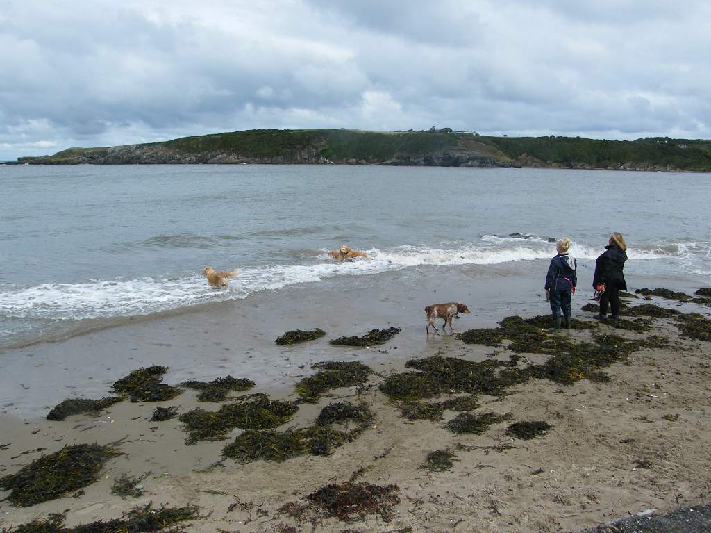
 We watched
some dogs playing in the water, they didn’t seem to mind the cold. Everyone was walking about in their winter
coats — we can hardly believe that only a few days ago we were basking in a
heatwave!
We watched
some dogs playing in the water, they didn’t seem to mind the cold. Everyone was walking about in their winter
coats — we can hardly believe that only a few days ago we were basking in a
heatwave!


As we left the harbour to get back on to the cliff path, we passed very close to a cottage with a white wall. A single snail had crawled halfway up it and really stood out against the whiteness.
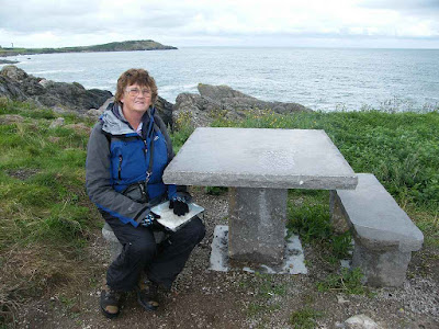
 We came to a marble picnic
table. Looking closely we could clearly see it was made from fossilised
coral. It was beautiful!
We came to a marble picnic
table. Looking closely we could clearly see it was made from fossilised
coral. It was beautiful!
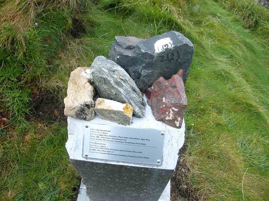
 Nearby were different local rocks stuck on
little stands with their geology explained in English and Welsh. Anglesey
really is a geologist’s paradise — they can argue to their heart’s content and
come to no conclusions whatsoever!
Nearby were different local rocks stuck on
little stands with their geology explained in English and Welsh. Anglesey
really is a geologist’s paradise — they can argue to their heart’s content and
come to no conclusions whatsoever!
 We
were brought here two years later on that U3A field course, and I didn’t
understand a word of it — and I have an honours degree in geology! Trouble is, that was nearly thirty years ago,
so most of it is forgotten.
We
were brought here two years later on that U3A field course, and I didn’t
understand a word of it — and I have an honours degree in geology! Trouble is, that was nearly thirty years ago,
so most of it is forgotten.
We passed some huge rosehips, and came to a seat which was sheltered from the wind. So we sat there to eat our sarnies even though it was still raining. Brambles growing up partially obscured the view, but we didn’t care much because we were wet and cold.
 We could
have taken a path round Wylfa Head, but we didn’t because of the rain, and the
short-cut path was the more obvious one.
There was no signage for either way.
We could
have taken a path round Wylfa Head, but we didn’t because of the rain, and the
short-cut path was the more obvious one.
There was no signage for either way.
We were near Wylfa Power Station, and there the signage gave us a choice of two ways — either through a conifer wood or down a road. Naturally we chose the former which was almost pleasant because the rain was hardly getting through the foliage.

 Out of the wood the path was well-maintained,
grassy underfoot, and had neat steps up and over a little hill. I photographed a speckled wood butterfly on
the way. We came very near the power
station and found ourselves under a pylon at one stage. We continued following grassy paths, and came
out by a road junction.
Out of the wood the path was well-maintained,
grassy underfoot, and had neat steps up and over a little hill. I photographed a speckled wood butterfly on
the way. We came very near the power
station and found ourselves under a pylon at one stage. We continued following grassy paths, and came
out by a road junction.
 We didn’t know where we were, we couldn’t relate it to the map at
all. We tried one way on the road, but
it only led us to the power station entrance.
We tried the other way, but ended up in a car park where there was no way
out. We came to the conclusion that the
map was completely wrong, and we
hadn’t seen a coast path sign since we entered the wood way back. With increasing frustration we tried to
orientate ourselves. We climbed over a
locked gate and followed a track which wasn’t marked on the OS map. We did this because I could see in the
distance another track which I guessed might actually be the coast path. We turned right on this track, and at the
next gate were coast path logos. So I
had been right! But how we were supposed
to get there from the path through the wood I don’t know — it certainly wasn’t
the way we came!
We didn’t know where we were, we couldn’t relate it to the map at
all. We tried one way on the road, but
it only led us to the power station entrance.
We tried the other way, but ended up in a car park where there was no way
out. We came to the conclusion that the
map was completely wrong, and we
hadn’t seen a coast path sign since we entered the wood way back. With increasing frustration we tried to
orientate ourselves. We climbed over a
locked gate and followed a track which wasn’t marked on the OS map. We did this because I could see in the
distance another track which I guessed might actually be the coast path. We turned right on this track, and at the
next gate were coast path logos. So I
had been right! But how we were supposed
to get there from the path through the wood I don’t know — it certainly wasn’t
the way we came!
Our troubles were not over, and remember it was still raining. The coast path arrow indicated we bear right and follow a track, but looking at the map (I had found the place by now) I said we should be going straight ahead. There was no obvious path ahead so we followed the track, but when it started to twist round going back on itself we realised the map was right and the signage wrong! The rain didn’t leave off and we had wasted a lot of time.
 We started again from the gate going round the end of a copse and down to
cross a mill stream. There was no
obvious path until we reached the mill stream, we just followed the map. We could see that we were about half a mile
from the coast at this point, and with relief we noted we were now well past
the power station.
We started again from the gate going round the end of a copse and down to
cross a mill stream. There was no
obvious path until we reached the mill stream, we just followed the map. We could see that we were about half a mile
from the coast at this point, and with relief we noted we were now well past
the power station.
 We were treated to a lovely vista of yellow gorse and purple heather
which we really appreciated despite the rain.
We were treated to a lovely vista of yellow gorse and purple heather
which we really appreciated despite the rain.
 The path was more obvious now and we followed it closely round a head —
back on the low cliff tops now. It
started raining heavily as we approached Cemlyn Bay,
a unique feature with a shingle bank.
But we couldn’t take any photos because it was raining too heavily. And it was cold.
The path was more obvious now and we followed it closely round a head —
back on the low cliff tops now. It
started raining heavily as we approached Cemlyn Bay,
a unique feature with a shingle bank.
But we couldn’t take any photos because it was raining too heavily. And it was cold.
We walked half a mile across that shingle bank — it was leg-shattering! It made my sensitive back twinge too. We saw a dead dogfish about eighteen inches long, we thought it might have been flipped up on the bank at high tide. We couldn’t photograph it, nor the colourful seaweed which looked really beautiful, because the rain was pelting down at that point.
 When we
got to Cemlyn Bay itself the rain held off momentarily
so I was able to take a couple of pictures.
There is an artificial lagoon and old buildings there, but I couldn’t
find out anything about the history of the place except that it is a nature
reserve.
When we
got to Cemlyn Bay itself the rain held off momentarily
so I was able to take a couple of pictures.
There is an artificial lagoon and old buildings there, but I couldn’t
find out anything about the history of the place except that it is a nature
reserve.

 I’m afraid we weren’t much in
the mood for nature by then, and when we saw a notice warning us that the car
park is liable to flooding at high tide, we wished our car was parked there so
we could terminate the Walk there and then.
I’m afraid we weren’t much in
the mood for nature by then, and when we saw a notice warning us that the car
park is liable to flooding at high tide, we wished our car was parked there so
we could terminate the Walk there and then.
But it wasn’t, so we carried on. We walked round a head and along the cliff path, though the cliffs were quite low by now. We could see the Skerries clearly, they weren’t far away.
 We came to a
choice of ways, neither signed with the coast path logo. The signage was completely absent for the
continuing coast path, a yellow arrow pointed inland.
We came to a
choice of ways, neither signed with the coast path logo. The signage was completely absent for the
continuing coast path, a yellow arrow pointed inland.
 It was still raining, we were cold, fed up and running
late. I looked at the map, and said,
“Forget the Coast Path, we are going to walk back to the car the quickest way
possible!” Colin was heartily
relieved! We followed the inland path
down a field until it touched on a road.
Then we followed a track where the grass got longer and longer —
obviously it was not often walked. We
came to a farm where we bore left on the farm road until we came to the public
road. According to the OS map, this is
the alternative coast path, though we were nowhere near the coast. We had missed out Carmel Head altogether.
It was still raining, we were cold, fed up and running
late. I looked at the map, and said,
“Forget the Coast Path, we are going to walk back to the car the quickest way
possible!” Colin was heartily
relieved! We followed the inland path
down a field until it touched on a road.
Then we followed a track where the grass got longer and longer —
obviously it was not often walked. We
came to a farm where we bore left on the farm road until we came to the public
road. According to the OS map, this is
the alternative coast path, though we were nowhere near the coast. We had missed out Carmel Head altogether.
We stayed on the road from thereon. We came to a car park where the coastal path was signed to veer off down a track back to the coast. We sat on a wall to eat our chocolate. We were both thoroughly fed up, cold and not enjoying ourselves at all. We were also running late — in a mere two hours it would be too dark to see, and dangerous to be out on the cliffs. It’s at times like this that we wonder why we are doing this coastal trek at all, but we knew that if it had been sunny and warm our mood would have been completely different. We decided to stick to the road.
We were both tired, though Colin would never admit it. He did admit to being fed up! We route-marched all the way to Porth Swtan and forgot about the coastal path. We seemed to climb uphill a long way, but we had a lovely view of Holy Island from the top. Then it was downhill the rest of the way. Porth Swtan is also known as Churchtown because it has a rather fine church. We met a local man and asked him if he knew why the steeple was on the side of the church, not on the end. He said he’d never thought about it.

 By then the rain had actually stopped and there were small patches of
blue appearing in the sky. But it was
still cold and beginning to get dark. The
road verges were splashes of bright colour — dark pink fuchsias which reminded
us of Irish hedgerows, and the infamous montbretia. The montbretia flowers are a bright cheerful
orange which look lovely along roadsides, but I have spent most of my adult
life attempting to eradicate this wretched plant from the gardens of the
various houses in which I have lived because it is so invasive. It is a dictator of plants, the ultimate
bully!
By then the rain had actually stopped and there were small patches of
blue appearing in the sky. But it was
still cold and beginning to get dark. The
road verges were splashes of bright colour — dark pink fuchsias which reminded
us of Irish hedgerows, and the infamous montbretia. The montbretia flowers are a bright cheerful
orange which look lovely along roadsides, but I have spent most of my adult
life attempting to eradicate this wretched plant from the gardens of the
various houses in which I have lived because it is so invasive. It is a dictator of plants, the ultimate
bully!
Colin walked on quickly from the church so’s he could present me with a hot cup of tea the moment I arrived at the car park. I followed more slowly behind a group of people walking down to a local restaurant. Two of the women were wearing very high heels, and were obviously uncomfortable by the way they were walking. Neither of them looked glamorous, just a bit stupid. Vanity! (Oh! I was in a grumpy mood!)
That ended Walk no.340, we shall pick up Walk no.341 in the car park at Porth Swtan It was twenty-five past six, so the Walk had taken us six hours five minutes. We had our tea and chocolate biscuits, then drove back to our caravan, thoroughly fed up with the weather.
Location: Cemaes Bay to Porth Swtan.
Distance: 9½ miles.
Total distance: 3511½ miles.
Terrain: Some cliff paths, but the cliffs were lower than yesterday — some almost on the rocky beach. Through woodland near a power station where we got lost. Half a mile of shingle beach — leg-shattering! Roads — winding quiet lanes — for several miles after we sort-of gave up. Undulating.
Tide: Going out.
Rivers: No.415, Afon Wygyr. No.416, Cemlyn Bay.
Ferries: None.
Piers: None.
Kissing gates: Nos.551 to 575 spread along the way. (24 in all!)
Pubs: None.
‘Cadw’ properties: None.
Ferris wheels: None.
Diversions: None.
How we got there and back: We were staying in our caravan on a remote farm in the middle of Anglesey. It was pouring when we woke this morning, and after yesterday’s torrential rain we didn’t feel at all like walking. But the forecast was for it to clear up ‘later’ — it lied! So we messed about a bit, then tardily drove to Porth Swtan where we parked in a free car park. We then walked uphill for over a mile to the village of Rhydwyn where we caught a later-than-planned bus to Cemaes Bay.
At the end we finished the Walk at the car. It was twenty-five past six, so the Walk had taken us 6 hours and 5 minutes. We had our tea and chocolate biscuits, then drove back to our caravan, thoroughly fed up with the weather.
We hadn’t properly dried out from yesterday, and when it was still raining as we woke this morning we really didn’t want to continue the Trek. It was cold too, like winter. The weather forecast said it would clear up later (it didn’t!) so we decided to go, but catch a later bus. We drove to Porth Swtan, but as we entered the car park we were followed by a convoy of Army vehicles — they had come to meet those “sponsored” walkers of yesterday whom they had dropped off in Cemaes Bay earlier to do exactly the same Walk as we were about to do. Now we really do question who pays for all this Army backup, especially as they completely took over the local café so these walkers could have their lunch when they arrived. We couldn’t have bought a cup of tea there even if we’d wanted to! Meanwhile, we had to walk one and a half miles to the nearest bus stop, then pay our own fares to Cemaes Bay.
No
wonder we were annoyed!


As we left the harbour to get back on to the cliff path, we passed very close to a cottage with a white wall. A single snail had crawled halfway up it and really stood out against the whiteness.


We passed some huge rosehips, and came to a seat which was sheltered from the wind. So we sat there to eat our sarnies even though it was still raining. Brambles growing up partially obscured the view, but we didn’t care much because we were wet and cold.

We were near Wylfa Power Station, and there the signage gave us a choice of two ways — either through a conifer wood or down a road. Naturally we chose the former which was almost pleasant because the rain was hardly getting through the foliage.


Our troubles were not over, and remember it was still raining. The coast path arrow indicated we bear right and follow a track, but looking at the map (I had found the place by now) I said we should be going straight ahead. There was no obvious path ahead so we followed the track, but when it started to twist round going back on itself we realised the map was right and the signage wrong! The rain didn’t leave off and we had wasted a lot of time.


We walked half a mile across that shingle bank — it was leg-shattering! It made my sensitive back twinge too. We saw a dead dogfish about eighteen inches long, we thought it might have been flipped up on the bank at high tide. We couldn’t photograph it, nor the colourful seaweed which looked really beautiful, because the rain was pelting down at that point.


But it wasn’t, so we carried on. We walked round a head and along the cliff path, though the cliffs were quite low by now. We could see the Skerries clearly, they weren’t far away.


We stayed on the road from thereon. We came to a car park where the coastal path was signed to veer off down a track back to the coast. We sat on a wall to eat our chocolate. We were both thoroughly fed up, cold and not enjoying ourselves at all. We were also running late — in a mere two hours it would be too dark to see, and dangerous to be out on the cliffs. It’s at times like this that we wonder why we are doing this coastal trek at all, but we knew that if it had been sunny and warm our mood would have been completely different. We decided to stick to the road.
We were both tired, though Colin would never admit it. He did admit to being fed up! We route-marched all the way to Porth Swtan and forgot about the coastal path. We seemed to climb uphill a long way, but we had a lovely view of Holy Island from the top. Then it was downhill the rest of the way. Porth Swtan is also known as Churchtown because it has a rather fine church. We met a local man and asked him if he knew why the steeple was on the side of the church, not on the end. He said he’d never thought about it.


Colin walked on quickly from the church so’s he could present me with a hot cup of tea the moment I arrived at the car park. I followed more slowly behind a group of people walking down to a local restaurant. Two of the women were wearing very high heels, and were obviously uncomfortable by the way they were walking. Neither of them looked glamorous, just a bit stupid. Vanity! (Oh! I was in a grumpy mood!)
That ended Walk no.340, we shall pick up Walk no.341 in the car park at Porth Swtan It was twenty-five past six, so the Walk had taken us six hours five minutes. We had our tea and chocolate biscuits, then drove back to our caravan, thoroughly fed up with the weather.

No comments:
Post a Comment