Friday, August 11, 2017

Walk 381 -- Nolton Haven to Little Haven

Ages:  Colin was 75 years and 95 days.  Rosemary was 72 years and 237 days. 
Weather:  Slate-grey sky, some rain, windy. 
Location:  Nolton Haven to Little Haven. 
Distance:  4½ miles. 
Total distance:  3898 miles. 
Terrain:  A little bit of road, a flat sandy beach at the end, but mostly undulating cliff path — a bit kinder than last time, only one chasm! 
Tide:  Going out. 
Rivers:  None. 
Ferries:  None. 
Piers:  None. 
Kissing gates:  Nos.926, 927, 928 and 929 near the start of the Walk, and no. 930 as we approached Broad Haven. 
Pubs:  St Bride’s Inn in Little Haven where Colin drank Bluestone “Rock Hopper” and Tenby Harbour “MV Enterprise”.  I didn’t feel like beer, so I sipped a bit of his! 
‘Cadw’ properties:  None. 
Ferris wheels:  None. 
Diversions:  None. 
How we got there and back:  We were caravanning near Whitesands Beach.  This morning we drove to Little Haven where we drove all round but had no choice but to pay £5 to park in the one and only car park.  We caught a bus to Nolton Haven. 
At the end we came to the car park in Little Haven.  We deposited our gear in the car, then went to the pub which was opposite.  (Wouldn’t like to eat there — very expensive!)  We then drove back to the caravan where again we had tea and cream cakes. 
The next day we returned home to Malvern.
We had to walk steeply uphill on the narrow road out of Nolton Haven, but it wasn’t long before we were able to turn on to the cliff path.  We met a lot of hikers again today despite the inclement weather, many were German or French.  The popularity of the Pembrokeshire Coast Path is very marked — they should try some of the other coast paths around the country where we have been entirely on our own for miles and miles.
 
We had good views of rocks, caves, etc, but it started to rain so we had to don wet-weather gear and put the camera away.  Colin slipped his small camera in his pocket so we could whip it out quickly and use it without it getting very wet.  Then it stopped raining!  But it did start again later.  He took several pictures of this dramatic coastline using his camera at my behest.
We came to a little sheltered nook where there was a bank we could sit on, so we sat there and ate our pasties.
 
It was a good path and fairly level until we approached Druidston Haven — where we were confronted with a chasm!  There were numerous steps down, some of which were huge.  Oh, my knees!  We took photos of an eco-house from a distance.
Some people we passed asked us if we knew anything about it.  When we said we didn’t they said they’d look it up on the internet, and moved on.
I managed the steps all the way down to beach level where we were surprised to find the wooden footbridge across the stream was labelled  NOT A PUBLIC RIGHT OF WAY.  We were passed by a local man, so we asked him about the legality of this.  He said the land belonged to the Druidston Hotel and that the bridge was for the use of patrons only, But he added that he had seen many hikers use it and no-one had been confronted.
But we decided to be ‘good’ and went up the ‘proper’ path to the road where we crossed the stream on the road bridge.  Colin popped back along the road to photograph the eco-house from the front.
 
We continued along the road to the Druidston Hotel entrance where there was a history board about the Roundhouse.  It was an essay, far too much to read — so we didn’t.  The path turned off the road, much to our relief, far sooner than was indicated on the map — but then this map is probably thirty plus years old so we couldn’t blame the Ordnance Survey for this one!  It led us behind a hedge to keep us off the road.
We came across a group of people miserably eating their lunch in the rain, wind and cold.  It looked very like the English ‘enjoying’ their summer holiday, but it turned out they were French.  They told us the Grandmama was 81 and out walking with her children and grandchildren.  A lovely family, and the 81 year old looked very robust and healthy.  (Mind you, she wasn’t all that much older than us!)
 
The access from the road to there was a wheelchair-friendly path which led to a fantastic viewpoint.  It was a pity the rain and mist spoilt it for us today, but it was still a marvellous view.  I held the umbrella so that Colin could take the picture, but it was so windy the brolly kept blowing inside out. 
We next passed an area where the whole cliff had collapsed to a lower level some years past.  It was a good path as we carried on, not too undulating so my knees coped brilliantly.  We came to a choice of paths —  either follow the cliff top and go down and up a bit, or take a short cut across the top.  We chose the clifftop route, but saw the Frenchies take the short cut.  We began to have views of Broad Haven — and it actually stopped raining.
 
We came to a plaque commemorating Glyn Charles, an Olympic yachtsman who was lost at sea in 1998.  Sad — he was only 33.
 
Colin noticed 
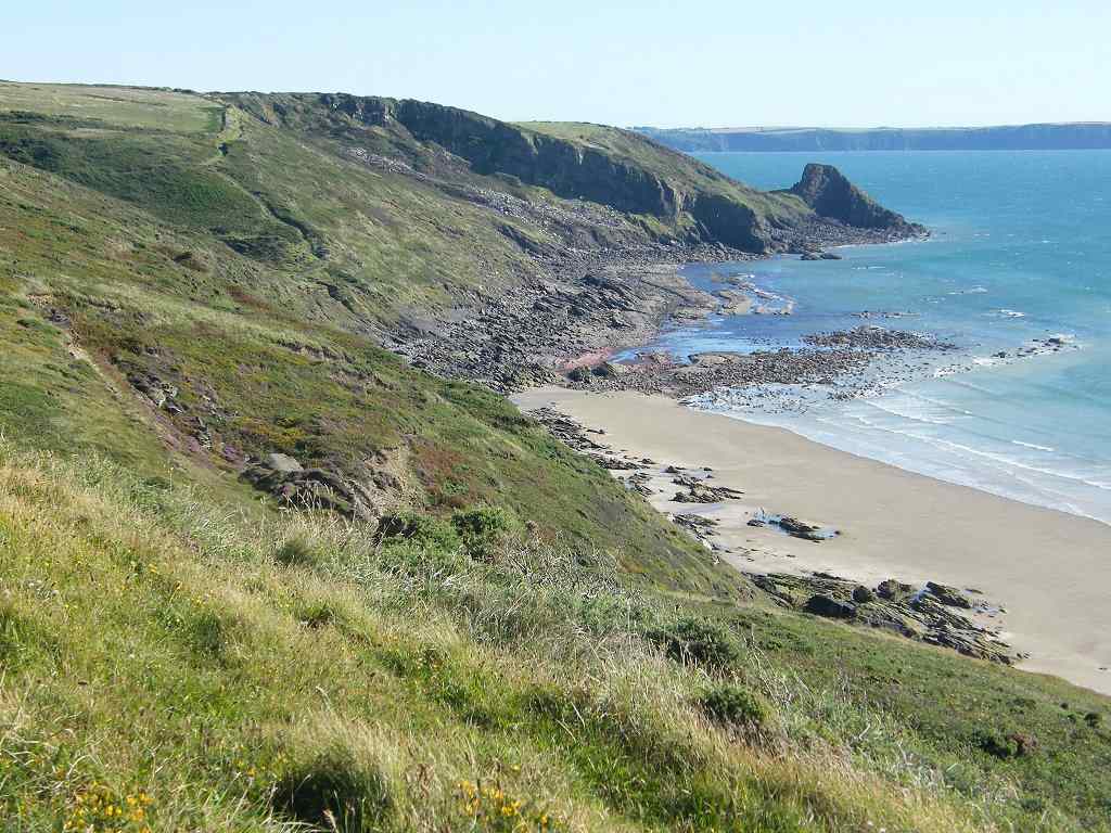
that the tide had gone out far enough to allow us to walk from Broad Haven to Little Haven on the flat sandy beach instead of climbing the hill between them.  I was dubious at first because it looked like rocks at the end of the cliff head we had to walk round.  But looking at the map, I saw it is marked as sandy at low tide.  And so it proved to be. 
We descended towards Broad haven gently (hooray!  my knees can cope with gently!)  and where the map said we exited on to the road, we didn’t.  The path continued behind a bank which was next to the road.  We came to a seat which was quite sheltered, so we sat on it to eat our chocolate.
 
We used the loos in Broad Haven, and when I came out I found Colin trying to take a photograph through the river bridge.  He was photographing oil tankers waiting to get into Milford Haven.  We went straight on to the beach and made towards the cliff head to the south.  We 
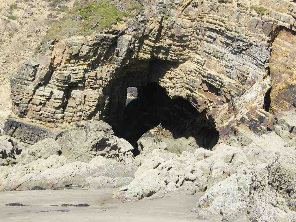
rounded it easily on the sand — a lovely walk!
 
There are lots of caves in the cliffs at several different levels.  And the geology looked interesting too, a lot has happened to those rocks over geological time.
We were mighty glad we didn’t have to climb up to the top of those cliffs.  I wouldn’t like to live in those houses at the top of the cliffs either — they might have wonderful views but I don’t think that cliffs are a very safe environment.
 
We rounded another smaller headland (oh! it was so wonderful to be walking on flat sand!) and came immediately to Little Haven where we walked up the slipway. 
 That ended Walk no.381, we shall pick up Walk no.382 next time on Little Haven beach.  It was ten past three, so the Walk had taken us three hours and fifty minutes. 
We walked to the car park where we deposited our gear in the car, then went to the pub which was opposite.  (Wouldn’t like to eat there — very expensive!)  We then drove back to the caravan where again we had tea and cream cakes.

Wednesday, August 09, 2017

Walk 380 -- Solva to Nolton Haven

 Ages:  Colin was 75 years and 93 days.  Rosemary was 72 years and 235 days. 
Weather:  Mostly sunny with a stiff breeze. 
Location:  Solva to Nolton Haven. 
Distance:  8 miles. 
Total distance:  3893½ miles. 
Terrain:  Challenging!  Mostly undulating cliff paths with numerous deep clefts accessed by lots of steps.  A good stretch of beautiful sandy beach, and a little road. 
Tide:  Out when it mattered! 
Rivers:  None. 
Ferries:  None. 
Piers:  None. 
Kissing gates:  Nos.917, 918, 919, 920, 921, 922, 923 and 924 near the start of the Walk, no.925 nearer the end. 
Pubs:  None. 
‘Cadw’ properties:  None. 
Ferris wheels:  None. 
Diversions:  None. 
How we got there and back:  We were caravanning near Whitesands Beach.  This morning we drove to Nolton Haven where we parked in the free car park.  We caught a bus to Solva. 
At the end we came to the car park in Nolton Haven.  We drove straight back to the caravan where we had tea and cream cakes. 
 
We started today’s Walk near the lime kilns where the coast path rises up on the south side of the Solva inlet.  We came to a stone telling us that this little headland was donated to the National Trust in 1937 by the former landowner in memory of his father and grandfather.
When we got to the top we realised that almost immediately there was a deep cleft which we had to descend all the way to sea level again.  I found this very difficult with my new knees, especially the right one which is only a few months old.  All those steps!  But I managed it.
 There was a wooden footbridge to cross the stream at the bottom and a shingle beach, but I was pleased to find that the actual path was on grass behind it.  Then we had to climb all the way up to the top of the cliff again.  I didn’t find this nearly so difficult as coming down even though it was tiring.  There were a lot of people walking the coast path today in both directions — Pembrokeshire coast path is very well known and popular with walkers from all over the world. 
We had spectacular views of the cliffs and rocks all the way along.  A lot has happened over geological time to these twisted rocks.  It was OK walking in the wind but it was too cold to sit in it.  So when we came across a bank sheltered by gorse bushes we made use of it and sat there to eat our pasties (not on the gorse bushes, silly, on the grass bank in front of them!)
Colin saw a bird of prey on the cliffs, he thought it might be a peregrine.  It was too far away to photograph.
The path was more ‘undulating’ than it appeared on the map — at least it seemed so to me.  We kept coming to deep clefts, and each one I found more difficult to get down to the bottom.  Some of the steps were huge — I tried to avoid them by stepping down the side but this was not always possible.
We sat on a low bank to eat our bananas.  Colin had to pull me up when it was time to go because I cannot kneel on my new knees and I haven’t yet the strength in my legs to pull myself up unaided.  But I am getting stronger and it is getting easier.
 
From where we were sitting we could see the tide was out on Newgale Beach.  We discussed the possibility of accessing the beach from one of the deep clefts and missing out the last couple of hills.  (This gave me hope)  We chatted with a family who were passing — they said they were hoping to do the same.  But they went on much faster than us, so we never knew how they got on.
The first cleft we came to didn’t go down to beach level, so we had to climb out of it again.  The second one had a path of sorts, not the official coast path, which led right down.
It was a bit dodgy at the bottom — the stream fell down in a lovely little waterfall — but I sat down (not in the stream!) and Colin helped me negotiate the last step which was about eighteen inches high.  At last we were on a flat beach of firm sand!
 
It was wonderful to look up at the last couple of hills on the coast path and smugly realise we didn’t have to climb them.
We marvelled at the twisted rocks we were passing at the bottom of the cliffs we didn’t have to climb.
I looked them up later — it turned out they are Cambrian, very old.  A lot has happened to them over the past hundreds of millions of years. 
Soon we were out beyond Newgale with its stones along the top of the beach.  We had been so lucky with the tide — we had not planned particularly to walk at low tide today — because we would have been up there on the stones or on the road had the tide been in.  As it was, we walked nearly two miles on flat sand — fabulous!  It was quite breezy, but that made it all the more pleasant for it wasn’t at all cold.  The tide was well out and lots of people were enjoying this fantastic beach.  Many were kite flying, and we were passed by a sand yacht at one point — it was going very fast.  Loose sand was blowing in waves along the beach, but it was only at ankle level so it was not a nuisance.
 
We made for a flag which was at the place where the road goes uphill.  The beach continued a little further than that but we didn’t know if there would be a way up the cliff at the far end, so we thought we’d better make for the road exit.  There we walked up a narrow boardwalk to the lifeguard shed and sat on a low wall to eat our chocolate. 
From there it was two miles to Nolton Haven where our car was parked, but what a two miles!  It took us a whole hour longer than it should have done because the path was like a roller-coaster — up and down, up and down with huge steps to negotiate.  My knees were screaming!  First we had to walk about a hundred yards up the road, then we turned off on a path which immediately went down again — with lots of steps — almost to sea level.  That was when we discovered we could have easily come off the flat beach at that point!  Then it was up and down, up and down far more than was indicated on the map.
 
About half way to Nolton Haven we were sent down loads of steps to an area which was once mined.  It took me ages to get down.  Only a single chimney and bits of coal dust scattered on the steps remained to tell us coal was once mined here.  The geology map informed us that this part of the coast is formed of rocks from the Carboniferous period labelled “Productive Coal Measures”.
 
The beach came to an end about there, and from far back we had wondered whether we could access the path we were walking on from the beach at this point.  But we hadn’t dared risk it because we didn’t want to have to retrace our steps when we found we couldn’t.  We could see a sort-of path going down.  Colin followed it, but came back to say the end was far too steep for me to have managed.  That was a little comfort, but not much.
 
On we went, up and down, up and down — I really don’t know how my knees managed, especially the right one.  But the surgeon had told me my knees were so secure I couldn’t damage them no matter what I did, but that didn’t stop them from aching horribly!
We had to go down a particularly long flight of steps to a vertical rock which was stuck up as if it was a standing stone.  But I’m pretty sure it was natural.  It was difficult to photograph it because the sun was directly above it, but I had a go.
There was a family sitting there resting.  A bit later they passed us on the path, and I noticed that one of the teenage girls was struggling along in high-heeled shoes!!
 
We saw some more large toadstools, beautiful!  We had been seeing them all along this path. 
At last we came within sight of Nolton Haven, a lovely little beach tucked away in the cliffs.  Quite a few families were enjoying themselves there even though it was, by now, early evening when most families had departed.  We were relieved to get to the bottom of the steps knowing that our car was only a few yards away in the free car park.
 
That ended Walk no.380, we shall pick up Walk no.381 next time on Nolton Haven beach.  It was twenty-five to seven, so the Walk had taken us six hours and fifty minutes. 
We drove straight back to the caravan where we had tea and cream cakes.

Monday, August 07, 2017

Walk 379 -- St Non's to Solva

Ages:  Colin was 75 years and 91 days.  Rosemary was 72 years and 233 days. 
Weather:  Mostly a hazy sun.  It was warm with a welcome breeze in exposed places. 
Location:  St Non’s to Solva. 
Distance:  5 miles. 
Total distance:  3885½ miles. 
Terrain:  Undulating cliff paths. 
Tide:  Out. 
Rivers:  No.451, Afon Solva in Solva. 
Ferries:  None. 
Piers:  None. 
Kissing gates:  No.916 near start of Walk. 
Pubs:  None. 
‘Cadw’ properties:  None. 
Ferris wheels:  None. 
Diversions:  None. 
How we got there and back:  Yesterday we returned to Whitesands with our caravan.  This morning we drove to Solva, but this time we parked in a wide layby at the top of town to save a £5 parking fee.  We caught a bus to St David’s and walked down to St Non’s. 
At the end we came to the car park in Solva.  We bought ice creams and enjoyed them sitting at a picnic table on the other side of the river.  The car park attendant had gone home, so Colin walked the half mile up the road and brought the car down.  We drove back to our caravan. 
 
About six weeks later we came back.  It was a lovely sunny day, but not nearly so hot as it was when I was taken ill back in June.  I was in full health and raring to go!  We saw two lizards on a stone wall on our way down to St Non’s.  Colin was delighted, he loves reptiles and stopped to photograph them.  We sat on a bench by the well to eat our pasties.
 
Soon we were out on the coast path again with its wonderful views.
There were lots of walkers today, we don’t think we have ever been on such a crowded coast path — usually we are on our own.  But it was good to see whole families out walking.  The heather was in bloom, and we saw a cormorant on a rock.
 
There is a lovely sandy beach at Caerfai.  The large campsite on the cliffs above was full of tents this glorious August day.
It was lovely to see so many children enjoying camping for their holidays.  Our own four children used to love the freedom of a campsite, it was the only type of holiday we could afford when they were growing up.  As adults they now appreciate that we couldn’t have taken them to the huge variety of places that we did if we hadn’t taken a tent for our accommodation.  We got as far as Venice one year!
Here at Caerfai lots of families were coming and going on the steep path down to the beach carrying all their paraphernalia — including boats!
 
There was some confusion for us on the paths above the sands, it was not well signposted.  We didn’t want to go down to the beach, just continue along the coast path.  We managed it in the end by using our initiative — what’s that?  We stayed high up, the people down below on the beach looked like ants.
We marvelled at the twisted and colourful geology in the cliffs.
We came to a deep cleft which was very steep down and very steep up the other side.  My knees did not like it, especially my right knee going down.  After all, that knee is only six months old!  But I managed it, I always do.  Determination is the key.


There were giant toadstools on the cliff which Colin photographed from all angles.  We passed some ponies grazing, and looked back at more fantastic geology.  We were into “Wow!” overload. 
My legs were aching a lot, so when we reached the Trelerw inlet we found a bank to sit on and have a rest.  And eat our chocolate.  After that the path was easier until we got to the next cleft about a mile away.
 
We were caught up by a group of people.  There was a couple with three moaning children, and another couple with the man carrying a tiny baby in his arms.  The baby was asleep, and it had no hat in the glaring sun.  I was concerned, so Colin asked the father if they had a hat for the baby.  He brushed him off with, “I think my wife has one!” but didn’t put anything on the poor little mite’s head until much later, and then they only draped a tissue over it.
We stood aside to let them all pass, then further on they stopped so we passed them.  This happened three times, by which point we were getting intensely irritated by them.  The kids were moaning that they were lost, and their father kept vigorously denying this.  Eventually the baby’s father discreetly asked us where we were walking to and how far it was.  He seemed relieved when we answered “Solva!” and that it was less than two miles.  They hadn’t a clue — any of them!
 
I found the Nine Wells cleft very difficult to descend.  My knees, especially the right one, didn’t like it at all.  I managed to get up the other side, but I thought my right knee was going to give way it was so painful.  I really did wonder if I had come back to coastal walking too soon — but I had been doing so well up ’til now.  We found a bank where I could sit down and I took paracetamol.  At least the moaning family had moved on by then and we didn’t see them again — relief!  After about ten minutes the pain eased so we carried on.  The path was good and fairly flat.  The exercise of walking on an even surface eased the pain in my knee even more until it felt quite normal again.
 
On this stretch we passed even more amazing geology — rocks and cliff faces eroded into weird patterns and shapes, caves and rock arches.
 
 
We also saw something in the sea that looked as if it was once part of a ship, but we really didn’t know what it was.  Colin photographed a butterfly that we think was a ringlet. 
Colin took a narrow path nearer the cliff edge to get a better view, but I stuck to the main path — I wasn’t taking any chances with my knees playing up.  When I got to the corner Solva came into view.
We were at the sea end of a long narrow inlet that was full of boats.  It was very pretty.  Colin’s path rejoined mine a little further on, but I had to wait for him because his path was longer.
 
We were still very high up and Solva is at sea level.  The path descended gently at first, but later it got quite steep.  But my knee was OK this time as I took it very slowly.
As we got down to sea level we passed a signpost which had been clothed in crochet!!  It looked very pretty — but what a thing for someone to do!  There was a ‘Ban the Bomb’ logo on the old lifeboat shed.  I don’t know how long ago it was daubed on there, but we haven’t seen one of those in years.
 
We passed people crabbing, swimming and boating in this delightful place.  Further on we walked through the car park, bought ice creams, then crossed the river to sit at a picnic table near the old lime kilns to eat them.
 
That ended Walk no.379, we shall pick up Walk no.380 next time on the bridge in Solva.  It was twenty-five to five, so the Walk had taken us four hours and five minutes.  The car park attendant had gone home, so Colin walked the half mile up the road and brought the car down.  We drove back to our caravan.  That was a very enjoyable Walk despite my knees!