Saturday, June 22, 2019

Walk 388 -- Hundleton to Angle

Ages: Colin was 77 years and 45 days. Rosemary was 74 years and 187 days. 
Weather: Sunny and warm. A slight cooling breeze when we could get out into the open. 
Location: Hundleton to Angle. 
Distance: 9 miles. 
Total distance: 3955 miles. 
Terrain: Grassy paths through fields and wooded dells. Rather more tarmac than we had bargained for. Undulating. 
Tide: Going out. 
Rivers: None. 
Ferries: None. 
Piers: None. 
Kissing gates: No.956 — just one! (All the rest of the many gates were kissless!) 
Pubs: None. 
‘Cadw’ properties: None. 
Ferris wheels: None. 
Diversions: None. 
How we got there and back: We were caravanning in Freshwater East. This morning we drove to Angle where we parked near the bus stop. We caught a bus to Hundleton. 
At the end we came into the village of Angle and walked towards the church where we finished the official Walk. We went on about a hundred yards to where our car was parked. We drove to the car park at Freshwater West where we had some biscuits and tea from our flask whilst looking at a beautiful view across the sands. Then we drove back to our caravan at Freshwater East. 
We had intended continuing the next day, but the monsoon-like weather returned and dictated otherwise. The following day we returned home, having completed only half the walking we had intended this trip. 
 
We started today's Walk on the lane just outside Hundleton where we finished the Walk last time. We got talking to to an old man in a motorised buggy who was walking his little tiny dog. He told us he used to hike all these local coastal paths, and all over Scotland too, but there was nothing to beat Pembrokeshire! He wished us well as he drove off. It's horrific to think we might be reduced to a motorised buggy like that as we get older and not be able to walk the coastal paths any more! 
Further along the lane we were passed by a lone lady hiker who had been on the bus. At the bus stop she had dashed off in the wrong direction, but must have realised her mistake and was now catching us up. She greeted us as she passed and we never saw her again. Everyone walks faster than us these days! 
After about half a mile of tarmac we were able to turn off into a wooded dell by a stream. This was a relief, not only to get off the tarmac but also to get into the shade, for the day was turning very hot. This was where we saw a huge bracket fungus high up on a tree. We have rarely seen one so big! Further up this lovely shady path we came to a wall which was just the right height to make a comfy seat. So we sat down and ate some chocolate because we felt like it. We were conjecturing about the origin of various ruined walls we could see about when Colin said, “

There's a lime kiln behind you!” And so there was — a deep pit half hidden by tall weeds. I could have fallen in!
 
We continued upwards out of the dell and over a hill. There were loads of wild flowers on the way, but I only stopped to take a picture of a foxglove which was hanging above my head. At the top a beautiful view across the river revealed itself.
 
We descended into another wooded dell which was rather lovely, but all this up and down was beginning to get to us. We  are each feeling our advanced years and wished we still had the strength and energy of our younger selves. 
Coming out of the second dell we gradually rose up and saw more fantastic views over the river
We passed a power station with its resident hum. It was well screened by bushes and trees, but that doesn't get rid of the noise. We were both getting very hot and tired, it was lunchtime and we needed a rest. We were looking out for something we could sit on in the shade, but the only log we found was in the blazing sun. Then we came to a road, which quite surprised us because no road appeared to be on the map. (Closer scrutiny later revealed a thin 'white' road leading to the power station.) There was a kerb there with a neat grass verge, so I sat down because it was in the shade. Colin joined me. It was not a bad place to stop, a total of one car passed while we were sat there eating our lunch.
 
Across the road we descended through a wood. Colin stopped to photograph a beetle, or somesuch, and we were caught up by a Welsh couple whom we had met on the bus. Only they had stayed on the bus all the way to Pembroke and had already walked back from there to Hundleton then caught us up. Shame on us! They went on, much faster than we were walking. 
We came to another road, and this time we did know it was there because it was clearly marked in yellow on our map. Down the end of this road is a six hundred year old church
We didn't go into the chuchyard, just photographed it from the gate — with the flaring chimneys of the oil refinery rising up twice as high behind it. The juxtaposition of new and old!
 
Next to the church we found a picnic area with tables etc — we could have had our lunch in there! (We always find the ideal spot soon after we have weathered an inferior one and moved on.) The roar of the oil refinery chimneys was very loud, and somewhat spoiled the atmosphere of a charming little corner. (We wondered whether the Vicar had to shout his sermon above the racket — if the church is still used.) 
From there it was up and up and up next to a barbed wire security fence. The roar from the oil refinery was loud in our ears as the view over the estuary to Milford Haven gradually revealed itself. Colin faffed around for ages photographing the flames at the top of the chimneys. While I was waiting for him the Welsh couple, previously mentioned, came into view. “
How did you get behind us?” I asked. “We stopped at the picnic site to have our lunch!” was their reply. (The hare and the tortoise?) They certainly seemed to have got themselves far more organised than us! Again they went ahead, walking much faster than we could.
 
We walked for about a mile along the top, the oil refinery with its loud roar to our left and views across the estuary to Milford Haven to our right. Cows and sheep were grazing up there. We could see mountains on the horizon behind Milford Haven and guessed they might be the Preseli Mountains. We could see water fountains playing over the jetties on the Milford Haven side of the estuary and wondered what their purpose was.
 
We descended into trees right down to beach level because we had to go underneath the pipes taking the oil from the tankers to the refinery. It was a steep climb up out of the other side, but the path stayed amongst trees which was much more pleasant than being out in the sun. We were both feeling the heat and were quite weary. We found a rock to sit on and ate some more chocolate because we felt like it.
 
Further on we met a group of people coming towards us. First was a woman with two dogs. Following her was a bare-chested man with one dog. And trudging along behind, wearing simple sandals, was a woman with no dog. None of them seemed to have extra coats, rucksacks or similar. The last woman asked me, “
Are we nearly at the castle yet?” “Which castle would that be?” I asked, racking my brain to think of a castle we had passed today. “Pembroke Castle!” she answered, “I keep hoping it will be just round the next corner!” “But that's miles away!” I blurted out, “at least five miles!” Her face dropped. “Probably more!” chipped in Colin, “and it's very up and down!” She hurried on to catch up with the others, and we wondered for the rest of the afternoon whether they ever got there.
Some people have no idea of maps, distances, or what hiking entails before they set out on a walk, and then they wonder why they get into trouble.
 
At Bullwell Bay we had to walk round a little inlet, but thankfully it was all on the level. Part way round we passed another lime kiln. There are so many of them around the coast in this area, it must have been big business in the old days.
 
We then cut away from the coast going uphill because the path cuts a corner of Angle Bay, missing out an old fort. The roar of the oil refinery was much less here because the hill was now in the way. Looking back there was a fine view of the estuary, and I decided to take a picture of Colin with that behind him.
But he was bent down taking a picture of a caterpillar, and before he stood up a group of hikers coming the other way had caught up with me and got in the way. They all stopped further down the path to watch an Irish Ferries ship sail through the view — so that is the picture I took, not at all like the picture I had originally intended.
 
These hikers told us that further up the path was a “funny kind of barrier” which blocked the way. They had taken a detour all round the fort in order to get past, but it was”a bit of a long way round”. Oh no! That's all I need when I am so tired and weary! As a parting shot one of the men said, “We couldn't see a reason for the barriers, I expect you can ignore them though you'll have to climb over them!” I'm not very good at climbing over things with my stiff back and metal knees, so we continued in some trepidation.
 
We could see the fort to our right, and soon we came to a road and the barriers. They were obviously only for traffic, not pedestrians, and were easily moved aside. We got past without any climbing. Halfway down the barred off road was a fractured culvert which had obviously been replaced. The concrete over it was still setting, so that was why they didn't want cars going down there. We were able to step over it without touching. People panic too much about such things and don't stop to ask, “Why?” I was very glad we didn't have to detour round the fort. 
We were now in Angle Bay, and rather disappointed. From the map we thought we would be walking a path along the top of the beach looking at the bay. Instead we were on a tarmac road between hedges for over a mile! There was hardly any traffic, but we didn't relish walking along a boring tarmac road towards the oil refinery once again. The roaring noise was getting louder too. I found my walking poles useful for power-walking, to get this boring part of the Walk over as soon as possible.
 
Where the road at last turned away from the beach there was a car park — well, a space for three cars. I had earmarked that spot for our last rest and chocolate. I was hoping for a seat there but there were none, so we sat on a stone.
 
The path led on, and it really was a path this time, along the top of the beach all round the bay. Colin was keen to walk on the beach instead, and I stupidly followed him. It was OK for a bit but not marvellous. Then it got stony, slippery and sinky. We couldn't get back up on to the proper path because there was a sheer wall. Colin said, “There's a slipway over there, we'll get up there.” It wasn't a slipway, it was a piped stream outlet. 
I climbed up that!
We carried on slipping and sliding. There was a break in the wall with natural rocks instead of bricks. This looked a possibility. There were 'sort-of'' steps in the rock, then an earth cliff which we could dig into — at least that was the theory. Colin had to haul me up because I hadn't the strength to pull myself up. The final straw was an electric fence. We both got two belts off it before I sat down and rolled underneath. And I got stung in the process. Then I couldn't get up — my legs are not strong enough to push me up and I cannot kneel on my artificial knees. Colin had to haul me up to standing.
Really, we are too old for such high jinks! Colin did admit that walking on the beach today was not one of his best ideas.
 
We still had about a mile to go and it seemed interminable. We walked through field after field, all with a pair of gates at each end — and none of the gates were kissing gates! Between one of the pairs of gates was another lime kiln, the third we passed on today's Walk.
 
The last bit of the Walk, into Angle, was through trees and it was rather pleasant.
The path turned into a tarmac drive, but we walked on the grass at the side.
There were pictures of birds and animals on the signposts, in the fields and on trees.
It was like a child's fairyland.
 
We met an old lady who was local, and she asked us about our Walk. She said the local bus driver was very good, he even stops at the public toilets and waits for anyone who wants to go! (Now that's my kind of bus driver!) 
Later she came back and stopped to chat again. She said she had met a man who planned to walk the entire Pembrokeshire Coast Path in 72 hours so he could claim the 'record'. I said he must be a nutcase. She strode off, faster than we could walk.
 
At last we came into the village of Angle. A car slowed down and a woman called out from its window, “I think we all deserve a beer!” It was the Welsh couple who had walked from Pembroke and passed us twice — only they had also walked on to West Angle Bay where they had parked their car. We came to the village church.
 
 
That ended Walk no.388, we shall pick up Walk no.389 next time at the village church in Angle. It was ten to six, so the Walk had taken us seven and three quarter hours. We went on about a hundred yards to where our car was parked. We drove to the car park at Freshwater West where we had some biscuits and tea from our flask whilst looking at a beautiful view across the sands. Then we drove back to our caravan at Freshwater East. 
Are we getting too old to continue the Round Britain Walk? Today's Walk was only nine miles, the terrain was quite kind, but we're both knackered! 
We had intended continuing the next day, but the monsoon-like weather returned and dictated otherwise. The following day we returned home, having completed only half the walking we had intended this trip.

Thursday, June 20, 2019

Walk 387 -- Pembroke Dock to Hundleton

 Ages: Colin was 77 years and 43 days. Rosemary was 74 years and 185 days. 
Weather: Sunny and warm with a lovely breeze. (At last Summer has started!) 
Location: Pembroke Dock to Hundleton. 
Distance: 6 miles. 
Total distance: 3946 miles. 
Terrain: Some pavement-bashing. Paths through fields and woods. Slightly undulating. 
Tide: Out. 
Rivers: No.457, Pembroke River. 
Ferries: None. 
Piers: None. 
Kissing gates: Nos.946 to 955 — ten in all. (The 10th was overgrown with goose-grass, but we still used it despite the main gate being wide open!) 
Pubs: The ‘Old King’s Arms’ in Pembroke where Colin drank Felinfoel ‘Double Dragon’ and ‘Gower Gold’, and I had a shandy. 
‘Cadw’ properties: None. (Pembroke Castle is privately owned, but is open to the public) 
Ferris wheels: None. 
Diversions: None. 
How we got there and back: We were caravanning in Freshwater East. This morning we drove to Hundleton where we parked near the bus stop. We caught a bus to Pembroke Dock Station. 
At the end we came out on to a lane about a quarter of a mile outside Hundleton. We walked into the village where our car was parked. We got in and drove straight back to our caravan. 
 
We started today's Walk at Pembroke Dock station. We walked to Asda hoping for a delicatessen counter and a toilet — they had neither. But there was a public toilet across the square at 40p a go! (
Thank goodness for our RADAR keys.) In the square was a sculpture, it was a huge fish with its mouth wide open as if it was dying. It was made entirely from plastic bottles! We thought it was very clever, it certainly put a message across.
 
Today's whole Walk was accompanied by NOISE! Horrible man-made NOISE! In Pembroke Dock it was constant traffic noise, and “disco” cars with their loud
thump! thump! thump! We didn't enjoy walking through the town much — it seemed a little run-down though not nearly so run-down as Holyhead. Is it something to do with them both being ports?
 
Also we had a lot of uphill walking. Before we started I had said it would be a “flattish” Walk mostly through towns so I wouldn't take my walking poles. I regretted that later, and Colin constantly reminded me every time we came to an uphill part.
 
At the top of the hill there was a wood, and we realised there was a footpath through it which cut off a corner. That's better! Though we could still hear traffic noise. It was only about a hundred yards, but it made a nice break from pavement-bashing. Then it was back on the road with the traffic noise and “disco” cars. 
It was Colin who noticed the path leading off to the left. I almost missed it because it seemed obscure, but it was well signposted. It led down into a lovely wooded dell — lovely except for all the broken glass, drinks cans and plastic rubbish which was strewn everywhere! Then it led uphill into a housing estate. But at the end of that road we continued into a real field. That's better! 
We found a rock to sit on in the shade and ate some of our lunch even though it was only 11.30. (We were hungry!) But it wasn't the peace of the countryside that we had been expecting — in the adjacent field up a bank they were cutting and turning hay. The machinery was so NOISY, and could be heard a long way. When we got to the end of the field I was about to go the wrong way again, but Colin called my attention to a crossroads of footpaths. We had to go steeply up a bank and into the very field where they were noisily haymaking. 
The path continued for about a mile through fields, flower meadows and wooded dells
We crossed a couple of streams and had the occasional view of the Pembroke River. But all along there was
Noise! Noise! Noise! First it was the haymaking, then it was a very loud drill (we couldn't make out where that was coming from) and as we approached Pembroke an extremely loud disco took over. (We think that was coming across the river from the castle.)
We think the birds were chirping in the woods, but we couldn't hear them above the racket!
 
We came out into a housing estate, and signs led us immediately down to the river opposite the castle. What a grand view! We sat on a bench to admire it and ate some chocolate because we felt like it.
The disco over the castle way was still in full flow — it came over in waves, extremely loud and then fading away in the wind before coming back. Also, the nearer we got to the bridge over the Pembroke River the louder was the traffic noise. The traffic was nose-to-tail over the bridge and all the way through Pembroke.
 
NOISE! NOISE! NOISE! 
On the bridge is a statue of Henry VII, the first Tudor king and father of the infamous Henry VIII. Henry VII was born in Pembroke Castle in 1457. After crossing the bridge we diverted into the town to seek out the real ale pub which we wanted to visit. Taking our drinks out into the concrete 'garden' at the back of the pub we were blissfully shielded from all traffic noise. But we had to listen to a lot of clattering and loud conversation from the adjacent kitchen. Then somebody started up a mixer, or something, which sounded like a large drill.
 
NOISE! NOISE! NOISE! 
We returned to the castle so that we could walk between it and the river towards Monkton.
(Hooray! The disco was no longer playing — perhaps someone had told them to shut up!) We didn't visit the imposing Pembroke Castle because it is not owned by Cadw. But we remembered visiting it way back in 1977 with our four small children. I have managed to find a photo of Colin standing on the topmost part of the keep where there are no safety railings with Paul, then aged six!
 
In Monkton we were able to take a shortcut up Awkward Hill — the traffic now has to go round two sides of a triangle whereas we did the Pythagoras thing. We passed Monkton Church and then walked under some trees where jackdaws were squawking, making a hell of a racket. I looked at numerous spots of birdlime on the pavement and thought, “This could be dangerous!” Suddenly a wet splat appeared just ahead of me as a bird flew off — it missed! I moved hurriedly out of the danger zone.
 
After half a mile of pavement bashing we turned into a lane that went sharply downhill to where an inlet came in from the river — the tide was well out so it was just mud. We crossed a bridge, the other side of which was an inland stream feeding into the inlet. But the water was coming through a large tap in a wall, it was quite extraordinary! It looked like something out of a children's cartoon.
Unfortunately, in the driveway of the dwelling next to this unusual tap, where a beautiful red Morgan car was parked, were two men drilling. The noise was excruciating and really hurt our ears.
 
NOISE! NOISE! NOISE! 
We didn't hang about! We continued hurriedly up the lane, 'up' being the operative word — this 'flattish' Walk had long since ceased to be a joke. We were both flagging by now, Colin particularly. My back was playing up and Colin's leg muscles were cramping. Thankfully we didn't have to climb all the way up the hill. Partway we turned off into a field on a footpath which followed the contours, more or less, around the hill. 
Further on we came to a fallen tree, the trunk of which made an excellent seat. So we sat down and ate some more chocolate because we felt like it. As we sat there we realised that, for the first time on this noisy Walk, we could only hear natural sounds — like the wind in the trees, birds singing, etc. But wait a moment! What was that in the distance? Only big guns booming out from the Castlemartin Range a few miles to the south! I wonder what QUIET sounds like?
 
The footpath continued through fields and wooded dells — it was quite pleasant. It crossed a couple of lanes and even passed a sewage farm (that wasn't very pleasant!) 
One of the stiles we came to was a real 'Granny's Teeth' affair. Colin had to help me get down off it — with my stiff back and metal knees I hadn't a hope of getting down those 'teeth' unaided.
Eventually we came to a tarmacked track. We turned uphill — again, but only gently uphill — for a quarter of a mile through a dandelion meadow until we hit a lane. 
That ended Walk no.387, we shall pick up Walk no.388 next time where the coast path turns on to a lane leading out of Hundleton. It was twenty to four, so the Walk had taken us five hours twenty-five minutes. We turned left and walked into the village where our car was parked. We got in and drove straight back to our caravan. We didn't meet anybody in either direction walking the coastal path today, and we voted it the noisiest of all the Walks so far. 
 
My knees no longer cause me problems when walking, in fact I hardly ever think about them these days because they feel so normal. Well done the NHS! It's only when I'm faced with BIG steps — ordinary sized steps are OK — that I haven't got the strength in the muscles around the knee to pull myself up or let myself down. Also, steep downhill slopes can be a problem because of the pressure on my artificial knees. I can walk for miles on the flat, and enjoy doing so. 
It's my back that's the real problem — it's arthritis again. And I have sciatica all down my right leg, probably caused by me limping when my knees were bad. The NHS doesn't want to know. I self-registered for physiotherapy, but when I eventually got an appointment (after three months!) it was a complete waste of time. At the first session I was given an exercise sheet, and the therapist didn't listen when I told her I was already doing the exercises daily. She didn't even touch me! And she dismissed me after two short sessions, the second session consisted of me showing her the exercises I had been doing. Our chiropractic daughter now lives on a yacht and we hardly ever see her. I tried a McTimoney chiropractor, and enjoyed the massage (at least she touched me!) but it didn't do any good and I felt it was money down the drain. So I do the exercises, take paracetamol and try to live with it. 
Colin has been suffering leg cramps for eighteen months now, and can be in excruciating pain at times. The GPs have run out of ideas and interest in his distress. He had a similar experience with a physiotherapist when he self-registered. So he does the exercises daily, takes paracetamol and tries to live with it. 
To quote the actress Bette Davies: “Growing old is not for sissies!”

Tuesday, June 18, 2019

Walk 386 -- Milford Haven to Pembroke Dock

Ages: Colin was 77 years and 41 days. Rosemary was 74 years and 183 days.
Weather: Dull, grey and occasional spots of rain. (Disgusting weather for June!)
Location: Milford Haven to Pembroke Dock.
Distance: 9 miles.
Total distance: 3940 miles.
Terrain: Some traffic-dodging roads. Some pavement-bashing. Some grassy paths. Occasional see-through metal bridges! Undulating.
Tide: Out most of the day.     
Rivers: No.454, Hubberston Pill. No.455, Castle Pill. No.456, Westfield Pill. No.457, Daugleddau.  
Ferries: None.
Piers: None.
Kissing gates: Nos.944 & 945. (All the other gates were kissless!) 
Pubs: None.
‘Cadw’ properties: None.
Ferris wheels: None.
Diversions: None.
How we got there and back: Two days ago we towed our caravan to Freshwater East Caravan Site. (We were a day later than intended because, just as we were about to leave home, the car battery decided to give up the ghost. Then the door lock on the caravan pinged off in several pieces on to the patio. By the time all that was fixed, it was too late to travel to Pembrokeshire that day. So we came indoors and opened a bottle of wine!) This morning we drove to Pembroke Dock where we parked in a street near the station. From there we caught a bus to Milford Haven Tesco, near where we had finished the last Walk 21 months ago.
At the end we came to the car which was parked near the station. We got in and drove straight back to our caravan.
 
Nearly two years! We hadn't intended it to be so long, but we had a bit of bad luck. Shortly after we returned home last time, Colin drove the car through a ford which was deeper than he thought. Water got into the engine, and the car was a right-off! We had to buy another car because the bus service has been withdrawn from our village and it is a two and a half mile walk to the nearest town. We felt trapped in our own home.
BUT.....we were paying off a huge mortgage in lump sums, it was nearing the end of the time allowed to pay it off and the mortgage company were beginning to send mildly threatening letters. We hadn't a penny to spare.
Fortunately our local garage had a little Ford Fiesta for sale quite cheaply. A lovely little car which did for our immediate needs
BUT.....you cannot tow a caravan with a Ford Fiesta!
Eventually, by tightening our belts and staying at home, we paid off the mortgage by the end of 2018. Relief! It had been a millstone round our necks ever since we moved to Malvern in 2007. Now the house of our dreams is fully ours, down to the last cobweb! And we have all this surplus pension money coming in which we don't have to immediately send off to the mortgage company! 
For the first time in our lives we don't have to penny-pinch — we can relax and afford things! By 1st May 2019 we had bought a Vauxhall Insignia which tows our caravan beautifully. At last we are back in Pembrokeshire, so let's get started!
 
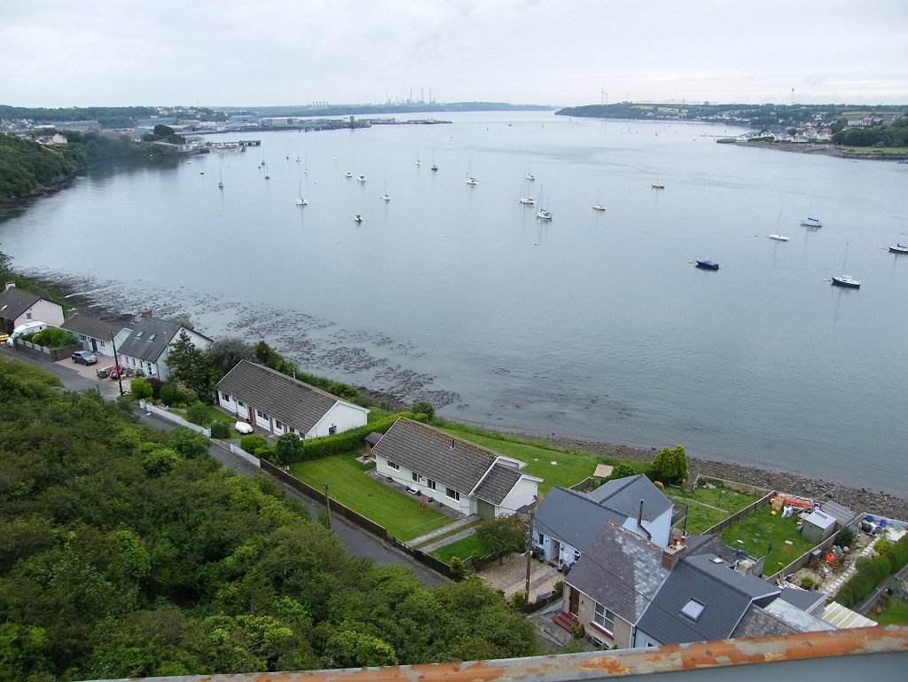
We went into Milford Haven Tesco to buy our lunch, but we left disappointed for two reasons. (a) They have closed their delicatessen counter so we couldn't buy the lunch we wanted. (b) They hadn't got a café and we had fancied a hot chocolate before we started our Walk.
We climbed up on to the “bridge” over the river, and it was only then we realised we could have stayed below because of the culverting. We could have saved ourselves a climb.
Our OS map for this area is about 30 years old and it directed us up the main shopping street. But we were delighted to find that there is now a footpath along the waterfront which is lined with little shops and cafés because this part of the river is now a marina. We dashed into the first café we came to and ordered hot chocolate to cheer ourselves up. We are so fed up with this rotten weather, as is everyone else. 
But this won't do, we have a Walk to do!
We continued along the waterfront to where the shops gave way to terraced houses. Several of them had gnomes on their tiny front patios, and one was a witch's garden!
The waterfront came to an end and we had to climb a steep hill inland. This came out in a residential road where there was a bridge over a disused railway. We tried the residential road first, but it was a dead end and we had to retrace our steps. We wanted to get down on to the old railway which is now a tarmacked path, but there was no way down that we could see. (The complete lack of any signage for walkers was disgraceful.) So we continued steeply uphill until we came to a path leading off in our direction. This remained high above the disused railway for several hundred yards until, at last, there was a linking path down to it. We were puzzled as to how we had missed the beginning of this railway path back in Milford Haven. 
Having met no one since we left the shops/café area on the waterfront, here we met several dog-walkers, some of whom stopped to chat. But the 'railway' soon ended at an unfriendly locked gate with '
keep out' notices all over it. Beyond was an industrial area which looked mostly disused, including a swing bridge across Castle Pill. 
We followed a path leading uphill to a house, and thought we would have to climb further up the hill on a road. But then Colin spied a narrow path leading up behind the house through bushes. Initially it was quite steep, but it soon levelled out. It would have been a lovely path through trees with views of yachts moored in Castle Pill, except for one thing —
the rubbish! There was litter strewed everywhere, mostly plastic junk-food wrappers and drinks cans. It was horrible! 
We passed a Celtic Cross which was disappearing into the undergrowth. We came to a slipway, but the way on looked a bit slippery. We could see the road bridge across Castle Pill (Black Bridge) but that was up high and we were down low. We didn't know whether to follow the soggy shoreline or to go uphill on a lane. There was no one about to ask, and
no signage! We decided, after much discussion, to follow the soggy shoreline since the tide was out. We had to be very careful not to slip — thank goodness I had my walking poles
It led us round the last corner and gently up to the road. There we found the
first Wales Coast Path sign on this Walk! Up until this point we'd had to use our initiative — good job we know what that is! Behind the sign was a seat that didn't look as it was used very often. 
We walked down the twisty hill to the bridge. Part way down was a bunch of flowers wrapped in plastic stuck in a tree, and lots of other plastic wrappers from previous bunches of flowers which had been stuck there. It did look a mess — why can't they take the plastic away and dispose of it? 
We crossed the bridge — now where? No signage, of course. I wished I had looked at the map more closely using a magnifying glass, but my eyesight is not that good on tiny detail and the green blobs on the map said go up the road. So up the hill we trudged dodging traffic on all the twisty bends for the road was quite busy. That part of the Walk was
horrid! Again we were aghast at the amount of rubbish by the side of the road — Costa coffee cups, crisp bags, Coca Cola tins, takeaway cartons, lager cans, etc — we reckoned it had been chucked out of car windows. With relief we reached the track leading to Venn Farm. I took off my high-viz waistcoat — Colin hadn't been wearing his because he couldn't remember where he had put it. 
We bypassed the farm, crossed a field and descended into a little wooded dell to cross a stream. Colin found a log where we sat and enjoyed our lunch. Just as we were commenting that we were on our own, we were passed by several other walkers. Two ladies who stopped to chat told us that after they had crossed Black Bridge a local lady told them of a different way up the hill away from the road. We wished we had met that local lady!
 
The path was well defined from there all the way to Hazelbeach. We were passing a lot of industrial constructions, all to do with the oil terminal. But, like the path between St Ishmael's and Milford Haven, it was a lot greener than we had anticipated. In fact, it was generally a most enjoyable Walk.
We came to a metal tunnel which was a bridge across a chasm.
(We were grateful for that, we didn't have to descend into the chasm and climb out the other side!)
 
We came to a metal bridge across numerous pipes which take in the oil from the tankers at the jetties — but there were no tankers there today. It's a good job neither of us are bothered by heights — looking straight down at the 'floor' of the bridge we could see a long way down and it was like walking on nothing!
An Irish ferry passed as we were doing this, reminding us that we once caught a ferry from Pembroke Dock to explore Ireland, in 2000 I think it was. A third bridge was high up over a private road which was inside the oil terminal complex, and again this bridge had an 'invisible' floor.
 
We met several hikers going in both directions. A couple of men stopped to chat for about ten minutes. We were swapping our experiences of the Wales Coastal Path.
We stopped in a little dell where someone had previously lit a campfire. There were logs to sit on, so we had a rest and a snack. We had to climb out of there, but the way was through a lovely wood. Eventually we came to Hazelbeach.
 
Hazelbeach is a lovely little village. There were several pairs of swans on the mud, some had very young cygnets alongside.
There were geese with goslings in the stream, and the male goose had the colouring of a mallard duck!
We walked along a lane in front of and between houses. We passed an old church, and someone had a large rusty mangle, laundry size, outside their house.
We came to a mainer road with more traffic, but it had pavements. On the mud there were more swans with cygnets. When the road turned inland away from the shore, we left it to go into a large car park so that we could stay on the waterfront.
There we came across a statue of Isambard Kingdom Brunel. We were both very weary by then and wished the Walk was over. But it wasn't, we still had to cross the river. To do this we had to get up on to not one, but two high bridges. We could see both these bridges from the little park where we were standing, but how could we get up there? According to our 30 year old OS map we walk alongside the river for about a mile until we have gone under the first high bridge. Then there is a way up the cliff to get us on to the level of the bridge. We certainly hoped so — we were in no mood to retrace our steps!
To add to our troubles it started spotting with rain, but fortunately it didn't come to much.
So, kags on, we marched through gardens, a yacht basin with workshops and railway lines, past a pub and onwards following a cycle path.
All the while we couldn't see any sign of a way up the cliff to the level of the bridges. But sure enough, about two hundred yards beyond the first bridge a little yellow arrow on a post pointed to a narrow path up through the bushes.
It wasn't too steep because it zigzagged and there were some steps — and it got us up to the level of the bridges!
 
It was a bit hairy crossing the road when we got to the top because there was no central island and the traffic was coming thick and fast in both directions. But we eventually found a gap and crossed quickly alongside a cyclist. The views from the first bridge were spectacular. There were a lot of yachts moored in the river.
Then we had a long dull and noisy (traffic noise) walk to the second bridge. This one was longer as it crossed the main river and led into Pembroke Dock. It is half a mile long and was opened in 1975. Before that there was a ferry if you wanted to save a 28 mile detour. The views from this bridge were more of an industrial nature.
There are now no tolls to cross this bridge although we know there used to be — we have paid them in the past. The toll booths were still there when we crossed, there were notices on the approach saying “no tolls ahead” and there were stop signs still painted on the road. All this made us think that the tolls had only recently been stopped.
 
The first thing we passed after crossing the bridge was a burnt out hotel! It was a one-storey rambling building, and what was strange was that the fire seems to have been in lots of different parts of the building. There seemed to have been lots of little fires, not just one great big one. The property was fenced off.
 
We came to a roundabout, and noticed a lot of traffic was turning into an estate instead of using the main road. We wondered if it was a 'rat-run', a short cut into Pembroke Dock. If it went through it would mean we only had to walk along one side of a triangle instead of two. We looked at our OS map, but the area was marked as a mish-mash of industrial buildings and was obviously completely out of date. We decided to take the risk — and it paid off! We emerged at a roundabout just down the road from the station, and we soon got to our car parked in the street opposite. 
 
That ended Walk no.386, we shall pick up Walk no.387 next time near Pembroke Dock railway station. It was quarter to seven, so the Walk had taken us eight hours. We got in the car and drove straight back to our caravan.