Tuesday, April 12, 2011

Walk 271 -- Machrihanish to Southend

Ages:  Colin was 68 years and 339 days.  Rosemary was 66 years and 116 days.
Weather:  Brilliant sunshine but a cold wind.  Showers this evening, one ending in hail!
Location:  Machrihanish to Southend.
Distance:  17 miles.
Total distance:  2591 miles.
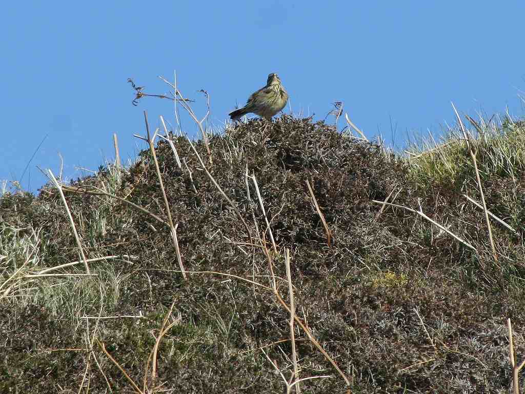
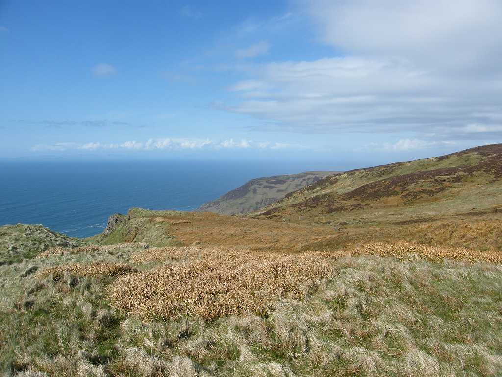
Terrain:  Tarmacked lanes at the beginning and end.  Some grassy tracks.  But mostly moorland ‘paths’ which were steeply undulating, very wet and boggy.  It was extremely difficult terrain to walk over for many miles.  But the views were stupendous!
Tide:  Going out, coming in and even going out again we took so long!
Rivers:  No.314, Abhainn Breacairigh.
Ferries:  None.
Piers: None.
Kissing gates:  No.219 as we entered Largiebaan Nature Reserve.  No.220 as we climbed a very steep hill.  No. 221 as we left Largiebaan Nature Reserve.
Pubs:  None.
‘Historic Scotland’ properties:  None.
Ferris wheels:  None.
Diversions:  None.
How we got there and back:  We were staying in our caravan in Machrihanish.  This morning Colin drove the car to Southend, caught a bus back as far as Stewarton, then thumbed a lift back to the caravan.  We both walked a quarter of a mile along the road to where we came off the beach yesterday.
At the end, we finished at the car in the dark.  I was totally exhausted, had pulled a muscle in my right leg and had three huge blisters on my feet.  We hurriedly drank our tea, then Colin drove us back to the caravan.
The next day I could hardly walk!  The blisters were a horrible mess and the pulled muscle was really painful too.  So we sorted ourselves out, and the following day we went home — 480 miles towing a caravan, all in one day!

My grandmother’s birthday again!  We have often walked on her birthday, must be a lucky time of year.  Happy birthday, Grandma — you would have been 133 today, and a hundred years ago you were pregnant with my Mum!

I waited for Colin to leave before I dressed my blisters this morning, because I knew he would insist on abandoning the Walk if he saw them!  They had spread, so I put two ‘Compeed’ plasters on side by side.  I knew I was chancing my arm, but I was absolutely determined to do this Walk today.  Colin got back quicker than either of us thought, and I hadn’t made the sandwiches nor done last night’s washing up.  At last we got going on what proved to be a challenging Walk.
We started at the point where we came out on to the road yesterday at the end of the dunes.  There was a small rocky promontory, then it opened out to a nice beach which was a couple of hundred yards long.  This was the only beach we walked on today.

We followed the road, which had become quite narrow, uphill through a farm.  Behind some buildings was a grotesque figure with a duck’s head.  It was huge, and we concluded it was a scarecrow.  It was quite steep up that road, but we were rewarded with magnificent views back along Machrihanish Beach and the airport behind it.


When it reached the trees, the road turned sharp right continuing even narrower until it turned into a track.  We passed a bathtub set into the ground with water pouring into it from an adjacent soggy field.  The bathtub was full of tadpoles! Nearby was a car park and a picnic area — one of the tables was occupied by a flowerpot man!  Despite the blue skies and bright sunshine, it was really cold in the wind.  We unsuccessfully attempted to shelter behind a noticeboard to eat our pies.
We came to a farmyard where we turned left through a gate on to a very muddy path.  There was loads of mud and farmyard cow-s**t making it difficult to negotiate.  At the top of a slippery muddy slope which we had to climb stood a hairy cow with menacing horns!
But these animals are very gentle really, and she (he?) backed off when we got up there.  We went through another gate, and the path was better, though still quite boggy in places, because it hadn’t been churned up by the cows.
The path stretched out before us, snaking its way across these remote moors.  We followed the ‘Kintyre Way’ signs — this bit of the Kintyre Way was well waymarked.
Magnificent views behind, the higher we got.  The path was quite well drained, but the moors either side looked very boggy.  A culvert was being inserted under the path at one point, and since the work wasn’t finished we had to ‘walk the plank’!
We went higher and higher to get over a pass.  As we started to go down the other side we had stupendous views ahead.  We really were in a lovely place, and all alone in the world!  In fact, we didn’t meet anybody between Machrihanish and Southend.
It was so soggy everywhere we had difficulty finding somewhere dry to sit down and eat our sarnies.  But eventually we came to a suitable rock above a gurgling stream — Innean Glen.  Wonderful views, and we were out of the wind so it actually got quite hot.
The path continued down Innean Glen, and we were intrigued by the words ‘Sailor’s Grave’ on the map.  It was located at the bottom of the glen.
As we got nearer we could see there really was a grave down on the grassy strand, marked out by white beach pebbles and a small wooden cross.  It was surrounded by sheep, no people down there.  We didn’t want to go down to it because it was a very steep path and a dead end.  We would only have had to climb back up again.
I looked on the internet to see if I could find any information about this grave.  Apparently in 1917 a local shepherd boy found a naked male torso in one of the rock pools at the bottom of Innean Glen.  No one has ever found out who he was, where he came from nor how he died.  Assuming he was a sailor washed up on the beach, the local people buried him in a simple grave near to where he was found.  Ever since they have tended the grave, keeping it neat and tidy and restoring it after storms have damaged it.  Passing hikers also help with this work.  Rather touching, don’t you think?
The next bit of the Walk was the best!  We were above the roaring surf, which we could hear quite loudly.  The sun was shining and we were out of the wind, so it was like a summer’s day.  And the scenery was simply magnificent!  That is what life is all about, moments like this.  We felt uplifted — it was a very good feeling.  Now we know why we are doing this trek!
We could see Ireland across the sea — the coast of Northern Ireland is only twelve miles from the Mull of Kintyre.  Even though the visibility wasn’t particularly good, we could make out the Antrim coast and some mountains behind it.
Then we had to climb, climb, climb — it seemed we’d never get to the top.  Every time we thought we were there, more ‘up’ would appear on the horizon.  But we did get there eventually, and we were treated to magnificent views over the Mull of Kintyre.  Our route was due to bypass this headland on the south-west corner of Kintyre because there are no paths leading to it from where we were.
We could have accessed it by rough-walking over the moors, but after our frightening experience on Walk 245, we made up Additional Rule no.16 which forbade us from doing so!  We had visited it by car two days ago.
The  Mull  of  Kintyre
We drove from Machrihanish up a narrow lane which was very steep and exciting in places!  We stopped to recce a possible shortcut which we hoped to use towards the end of the present Walk.  I didn’t want to upset my foot, so I stayed in the car while Colin wandered down the track to have a look.  He came back and said it was ‘no-go’.
So we drove all the way down the road sign-posted “Mull of Kintyre”, which was equally steep and exciting, until we came to a car park.  We were amused by a graffiti artist’s interpretation of a notice there.
An information board told us the following:
Made famous by Paul McCartney’s song in 1977, the Mull of Kintyre is the rounded headland making up the south-west corner of the Kintyre peninsula.  A lighthouse has stood here since 1788 to warn shipping away from this dangerous stretch of coast, where many shipwrecks now lie.  The present lighthouse, remodelled by the famous Robert Stevenson and automated in 1996, stands at the edge of a 300ft cliff.  Many aircraft have come to grief in the sometimes dense mist and their remains can be found around the peaks even today.  Nearby stands the cairn memorial to those lost in the “Chinook” tragedy of 1994.
The coastline of Ireland is only 12 miles away, the mountains and glens of Antrim, Fair Head, Malin Head and Rathlin are visible on a clear day.  In the north are the islands of Islay, Jura and Gigha.

A  CAUTIONARY  NOTE  TO  VISITORS
Congratulations on safely negotiating one of Scotland’s most exciting roads.  Cars must now be safely left in the car park — hairpin bends and steep gradients on the road to the lighthouse are even worse than those you have left behind!
Avoid putting lives at risk — communications here are poor, including mobile phone coverage.  The terrain is difficult, with hazardous hills and cliffs prone to rapidly changing weather conditions.  Remember this is home to sheep and a variety of wildlife — please keep dogs on leads.
I put on my old boots, since it was my new boots which had given me the blisters, and started walking down the road beyond the gate.  They were right about the hairpin bends and steep gradients!  I have been driving for forty years, but I wouldn’t have liked to drive a vehicle down that road.  We had good views of the lighthouse far below — it was a beautiful day.  We didn’t see the point of walking all the way down to the lighthouse, we would only have had to walk back up again.
There was a memorial stone partway down and off to the right, so we went there to find out what it was about.  In 1994 a Chinook helicopter crashed here in thick fog killing all 29 people on board.  Nineteen of them were high-ranking military personnel, Northern Ireland’s intelligence officers at the height of the ‘troubles’.  It was the RAF’s worst peacetime disaster.  Conspiracy theories abounded, and the first inquiry blamed the crew for ‘gross negligence’.  Subsequent inquiries cleared them, saying this verdict was unjustified.  It was probably just a consequence of the weather.  A tragic accident.

Meanwhile, back on the Walk we were revelling in the magnificent views from the top (well, almost the top) of Cnoc Moy.  The route down seemed more civilised — or so we thought — through fields of sheep and cows, even a goat.  But we were fooled, as we were to find out later on.
We turned into the Largiebaan Nature Reserve, and stopped in a gap in the trees, where we found some shade, for a rest and to eat our apples.  By now it was quite hot, and we had removed several layers.  The grassy tracks leading down from there were very pleasant to walk, and we were in buoyant mood thinking we had conquered the most challenging part of this Walk. 
But we were wrong! 
We came to a gate where we had been discussing which of two routes we should follow from thereon.  Route 1 was to continue following the track downhill, up and over the next hill, then zigzagging down to the Mull of Kintyre road where we would have to go back on ourselves for about a mile in order to get on to the road to Southend.  This was the ‘nearest safe path to the sea’ (though nowhere near the sea) but was longer.  Route 2 was to turn left and follow the official Kintyre Way over Arnod Hill and down to the river.  Then there would be four miles of road-walking along the lane to Southend.  I was concerned about the time — it was already approaching 6pm which meant we only had about two hours of daylight left.  I knew we couldn’t possibly get back to the car before dark, but I wanted to be on a real road before we lost too much light to see where we were going.  On the gate was a notice discouraging us from continuing down the track, reminding us that the Kintyre Way trail was off to the left.  They couldn’t actually stop us continuing on route 1 because of the liberal open access laws in Scotland, but the notice didn’t sound very friendly.  So we chose route 2. 
That was a BIG mistake! 
 The next three miles was like walking through a bog, it was dreadful!  Up and down, up and down with our feet slipping sideways — then up and up and up followed by very steeply down, it was a real roller-coaster.  Slippery, muddy and boggy.  It was swampy and squelchy — and my boots leaked for I was wearing my old ones.  I was amazed how well my blisters stood up to this treatment.  And we got rained on!  Two intensely sharp showers, followed by a hailstorm!  (That hurts!)  The rainbows we were treated to in between were little consolation.
Then I slipped.  I was trying to walk down a particularly steep slope when my left foot slid forward rather fast trapping my right leg awkwardly under my body as I sat down with a bump.  At first I wondered if I had broken my leg again — Oh no! — but I soon realised I hadn’t.  I had, in fact, pulled a muscle in my right leg and the pain was excruciating!  What to do?  We were miles from anywhere, and at least five miles from the car.  Mobile phones were useless because of the mountains, it was beginning to get dark and it kept raining.  It made us realise how vulnerable we were.  I had to go on, I had no choice.  Colin couldn’t carry me!  So I swallowed perhaps more painkillers than were good for me, got up on my feet and carried on walking.
We were both miserable by then, me especially so.  There was nowhere to sit down because of the mud, so we consumed our chocolate ‘on the hoof’ to give us more energy.  We got a bit lost as we approached the river, the waymarkers were too far apart and the topography didn’t seem to bear much relationship to the map.  Perhaps we were too tired, but we soon found ourselves after walking through a muddy field.
We had to backtrack three-quarters of a mile when we reached the river, to get to a bridge.  This annoyed us intensely because there did seem to be a farm track crossing the river where we met it, according to the map.  Colin had recced it out the other day (on our way to the Mull of Kintyre in the car) and realised it was impossible to access because of slopes, fences, brambles, etc.
At last we reached the bridge, and we were on the road.  Only four miles to go!  I put myself into ‘route-march’ mode and stomped off.  My blisters had obviously had enough by then and began to pain me, even though I was wearing my tried and tested old boots.  I stopped to take more painkillers — I think I was halfway to a junkie by then!  Then I began to get a pain in the ball of my foot too, as if I was treading on a nail.  Later that night Colin confirmed that I had yet another blister right under my foot, exactly where I put the full weight of my body at each step!
It was a very miserable me that arrived at the car in the pitch dark at ten past nine.  But at least I wasn’t stuck out on a remote mountain in the dark, unable to walk or get help.

That ended Walk no.271, we shall pick up Walk no.272 next time by the loos at Southend.  It was ten past nine, so the Walk had taken us ten hours and fifty minutes.  I was totally exhausted and in dreadful pain in my right leg and in both feet.  We hurriedly drank our tea, then Colin drove us back to the caravan.
The next day I could hardly walk!  The blisters were a horrible mess and the pulled muscle was really painful too.  There was no way I could carry on walking in the near future.   So we sorted ourselves out, and the following day we went home — 480 miles towing the caravan, all in one day!

Monday, April 11, 2011

Walk 270 -- Muasdale to Machrihanish

Ages:  Colin was 68 years and 338 days.  Rosemary was 66 years and 115 days.
Weather:  Mostly sunny.  Cold wind.  Isolated showers, most of which missed us!
Location:  Muasdale to Machrihanish.
Distance:  14 miles.
Total distance:  2574 miles.
Terrain:  Lots of beach-walking which was nice.  Lots of road-walking which wasn’t.
Tide:  Coming in — going out by the time we reached Machrihanish Beach.
Rivers:  No.311, Barr Water. No.313, Machrihanish Water.
Ferries:  None.
Piers: None.
Kissing gates:  No.218 at the beginning of Machrihanish Beach.
Pubs:  None.
‘Historic Scotland’ properties:  None.
Ferris wheels:  None.
Diversions:  None.
How we got there and back:  We were staying in our caravan in Machrihanish.  This morning we caught a bus just outside the caravan park to Campbeltown.  There we caught another bus to Muasdale.
At the end, we finished the Walk a quarter of a mile down the road from the caravan park.  So we walked back to the caravan and had our tea there.  We didn’t use the car at all today.

I had difficulty sleeping through the night after the last Walk because the blister on my right heel was so painful.  When I looked at it in the morning, I found it had spread sideways and was HUGE!  So we abandoned plans to walk for the next couple of days in order to give it a chance to heal.  I also bought ‘Compeed’ plasters, and found them to be very good.  Today I walked in my old boots — I have walked two and a half thousand miles in them, and they only gave me a blister once, when I got my feet wet.  Trouble is they leak, so I had to be careful to keep my feet out of mud and water — not always easy.

We got off the bus and went straight on to the beach.  It looked as if it was sandy, and so it was for about a mile.  We rounded a point where a fisherman was standing on the end, and there on a rock were about thirty seals basking in the sun.  It was a wonderful sight!
We sat on some grassy tufts to watch them, and ate our pies.  They didn’t do much, occasionally flexing their muscles like giant jelly-beans.  The tide was coming in, gradually turning their one big rock into lots of little ones and forcing some of them into the sea.  They seemed reluctant to give in.  I do so love seals!

We stayed on the beach until we came to some cliffs.  It was too rocky to walk beneath them, so we went up on to some grass, passed a herd of cows who were grazing there and exited through a gate on to the road.

This went inland for the next couple of miles, so we put on our fluorescent waistcoats and route-marched it.  Part way along we passed a War Memorial, seemingly in the middle of nowhere.  It was a reminder that nobody was exempt from the horrors of the two World Wars last century, not even people living in this remote area.


As we came down the hill to the beach again we got caught in a sharp shower.  We crossed over a river, then through a field to a caravan site.  It was a site I had considered using, but thought it might be too exposed with the winds we have been having lately.  We used their loos, then took ourselves down to a sandy beach where we found a spot in the dunes to eat our sarnies out of the wind.  It was hot sitting there in the sun, so we stripped off layers.  Two minutes after we left, the rain poured down again and the wind howled!  So we put the layers back on again — hey-ho!

From there we were able to walk the next two and a half miles along a firm sandy beach.  Absolute bliss!  We had really missed the sand and the surf when walking round all those lochs further north.  We had thought we might be walking on the road for this bit — so we loved this stretch, marching along with a spring in our step!

We had to come off the beach when we reached the hotel at Ballochantuy because it got too rocky.  The next four miles were boring and dangerous road-walking — so we went into route-march mode again.  We passed a boarded-up hotel, a sad sight.  Further on we stopped in a layby made from the old road to eat our apples.  It was difficult to find a place out of the cold wind.

We carried on route-marching.  There was a gap on the rock on our left-hand side which didn’t look natural, but if it was man-made, what was it for?  The beach on our right-hand side was full of rocks.
There were occasional bits of sand, but they were so tiny they weren’t worth going down on the beach for.
We passed a rock stack where birds were resting, and we spent a pleasant five minutes watching their comings and goings.
An old stone bridge took the old road over a dry river bed.

At last we could turn away from the traffic on to a bit of old road which ended in the car park for Machrihanish Beach.  There were quite a few people on this end of the beach, but they were mostly packing up for the day.
We watched the kite-surfers for a little while, but before long we were completely on our own!
We had four miles of sandy beach to walk, rolling surf to our right and dunes to our left.
It was ABSOLUTELY GLORIOUS!!
We really enjoyed this part of the Walk!


We saw a few piles of rubbish neatly stacked up against the dune cliff.  Further on we came across a seat made from beach rubbish and thought it rather clever.  At what we thought must be the halfway point, we sat under the dune cliff and ate our chocolate.


Machrihanish seemed to take a long time to get near us, but eventually we came to the river which divided us from the village.  No worry, there was a footbridge a couple of hundred yards upstream.  Colin got me to climb a sand-cliff, then he said “I’ve goofed!  We could have walked along the bottom to the bridge!”  Under ordinary circumstances this wouldn’t have mattered, but in scrambling up that sand my blisters, which had been dormant and painless all day, rubbed against the back of my boots and took all the skin off again.  The pain was excruciating!
I don’t know how I managed to limp back the other side of the river, along the dunes to the road, then back to the caravan site.  But I did!


That ended Walk no.270, we shall pick up Walk no.271 next time where we exited the dunes on to the road in Machrihanish.  It was five to seven, so the Walk had taken us seven hours five minutes.  We walked — limped in my case — a couple of hundred yards to the caravan site where we put the kettle on straightaway.  When I revealed my blisters, several had merged across the back of my heel.  It was all a horrible mess!