Ages: Colin was 66 years and 7 days. Rosemary was 63 years and 150 days.
Weather: Fair-weather cloud. No wind. Cool.
Location: Pennan to Gardenstown.
Distance: 5½ miles.
Total distance: 1578½ miles.
Terrain: Field, roads, tracks, and concrete. Undulating.
Tide: In.
Rivers: None.
Ferries: None.
Piers: None.
Kissing gates: None.
Pubs: None.
‘Historic Scotland’ properties: None.
Ferris wheels: None.
Diversions: None.
How we got there and back: We were staying in a cottage in Pennan. This morning Colin drove to Gardenstown, parked the car and walked back the shortest route he could find. When he returned, we started the Walk from the cottage.
At the end, we returned to the car park along the front at Gardenstown. After drinking tea from our flask, we drove back to Pennan.
The next day we started our long journey home to Malvern. We did it over two days because we are too far north now to manage it in one. We stayed overnight in a soulless motorway inn. The fact that it now takes two days to drive home from where we have been hiking really brought home to us how far we have walked. And our journey would have been another three hours if we still lived in Bognor!
That ends ten years of coastal walking !
(Next Walk, we shall be entering our second decade of coastal walking!)
(Next Walk, we shall be entering our second decade of coastal walking!)
We began today’s Walk in Pennan by the famous telephone box. In 1983 a film was made in the village. It was called ‘Local Hero’ and starred Burt Lancaster.  Much of the filming was done in Pennan, though the beach scenes were filmed near Arisaig on the west coast — that was because they wanted a sandy beach, and there are only rocks at Pennan. The red telephone box by the hotel (which was closed when we were staying there) featured in the film, in fact it played a significant role.
  People have come from all over the world to be photographed making a call from Pennan’s red telephone box, and the village has been basking in glory ever since. (The film is still repeated at regular intervals on TV.) So we thought a picture by the box was a good way to start.
 Much of the filming was done in Pennan, though the beach scenes were filmed near Arisaig on the west coast — that was because they wanted a sandy beach, and there are only rocks at Pennan. The red telephone box by the hotel (which was closed when we were staying there) featured in the film, in fact it played a significant role.
  People have come from all over the world to be photographed making a call from Pennan’s red telephone box, and the village has been basking in glory ever since. (The film is still repeated at regular intervals on TV.) So we thought a picture by the box was a good way to start.
 We climbed the steep road out of the village, and turned into a field where a path took us across two fields along the top of the cliffs. We could see how the cottages are tucked right under the crags leaving nowhere to go if the cliffs were to collapse. We could see the roof of the cottage which had been our home for two weeks, tucked in behind the others as if it is hiding. We were really glad we didn’t know the true story about the mudslide until after we got home!

Soon we had to come out on to the road, as there is no footpath along this beautiful coast. The road was closed to traffic due to repairs being done to its sides, but it was open to pedestrians. (In actual fact, Colin drove through there this morning to take the car to Gardenstown, and we drove back through there after the Walk.  The diversion was miles, so we were prepared to wait while they compressed the new tarmac and moved their machinery out of the way. It only delayed us about five minutes. We passed Nethermill where the ‘old road’ looped round over a little bridge so we were able to do a slight detour.
 The diversion was miles, so we were prepared to wait while they compressed the new tarmac and moved their machinery out of the way. It only delayed us about five minutes. We passed Nethermill where the ‘old road’ looped round over a little bridge so we were able to do a slight detour.
I was very slow going up the hill out of Nethermill, my toes hurt today due to friction against my boots. I don’t know why as my boots fit perfectly well. I think I was just tired. At the top of the hill we bypassed the road to a car park above Castle Point and Cullykhan Bay because it is a dead end. But we did go out there a couple of times on ‘rest’ days. Last week, when my blister was so bad that I could hardly walk, we drove down there to recce out the possibility of a footpath through to Troup Head. We met a local lady in the car park who was walking her dog.  She told us there was no way through — even the footbridge in the woods, which is marked on our map, had been ripped out by the owner last year because some kid had fallen through it and tried to sue him for negligence! (Don’t they know that part of the ‘Open Access’ code in Scotland says you must take responsibility for your own actions?) So we gave up that line of enquiry.
 She told us there was no way through — even the footbridge in the woods, which is marked on our map, had been ripped out by the owner last year because some kid had fallen through it and tried to sue him for negligence! (Don’t they know that part of the ‘Open Access’ code in Scotland says you must take responsibility for your own actions?) So we gave up that line of enquiry.
In July, when we were staying in a cottage in nearby Gardenstown,  we again drove down to the car park. We walked down broken steps to the beach of Cullykhan Bay. There we found a HUGE cave that went right through to the other side of the headland. Colin was in his element, and disappeared into it for about half an hour! But it was too rough and slippery for me, so I didn’t risk it. When he eventually emerged, we both climbed up to the headland of Castle Point. It is the remains of an Iron-Age fort. From there we had fantastic views of the cliffs, of more caves in the next headland, and back towards Pennan even though it was getting increasingly misty while we were there.
 we again drove down to the car park. We walked down broken steps to the beach of Cullykhan Bay. There we found a HUGE cave that went right through to the other side of the headland. Colin was in his element, and disappeared into it for about half an hour! But it was too rough and slippery for me, so I didn’t risk it. When he eventually emerged, we both climbed up to the headland of Castle Point. It is the remains of an Iron-Age fort. From there we had fantastic views of the cliffs, of more caves in the next headland, and back towards Pennan even though it was getting increasingly misty while we were there.
Back to the present Walk. We marched for about a mile along the road, then turned off at Middleton. At Protston we ignored the road out towards Troup Head because, again, it was a dead end.


We passed other flowers too, including fantastic wild orchids.
We didn’t have to cross the river and climb up to the road (the contours are so close together it was difficult to see on the map) as the track we were on turned down to Crovie Harbour.


 TO COMMEMORATE THE BRAVERY OF
THE MEN AND WOMEN OF
CROVIE, GARDENSTOWN AND THE
PARISH OF GAMRIE
WHO ON FEBRUARY 11TH 1906
RESCUED THE CREW OF THE
SS VIGILANT
WHICH DURING A VIOLENT STORM RAN
AGROUND ON THIS SHORE

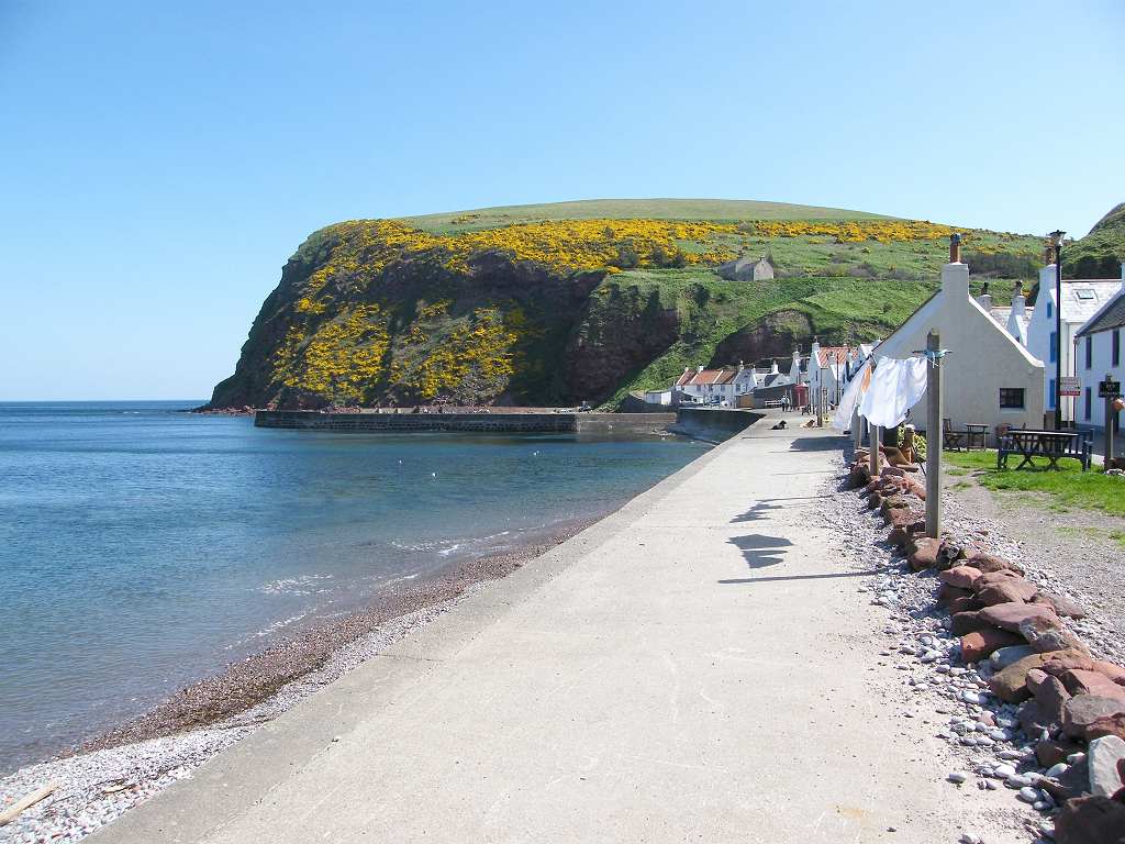
We passed a dribbly kind of waterfall, but pretty nonetheless, and then rounded the ‘dangerous rocks’, where cliffs rose spectacularly above our heads, into Gardenstown. This is a town rather than a village — it even has a bus service! The harbour is bigger, there are more houses, a pub and a shop, and the cliffs slope much more gently away from the shore.


That ended Walk no.183, we shall pick up Walk no.184 at the western end of Gardenstown. It was five to three, so the Walk had taken us four hours ten minutes. We returned to the car which was parked at the eastern end of town. After drinking tea from our flask, we drove back to Pennan.

It was only after we had asked them several times why they had stopped us and were delaying our journey that they said they had run our car number through their computer and there was “no record of any insurance”. (Now, our insurance ran out during our stay in Scotland this time. Knowing this, we had renewed it three weeks previously — the same policy with the same company — and paid for it in advance. Then we had forgotten about it as it was dealt with, but had brought the old as well as the new certificate with us.) So we showed them both our insurance certificates, and they let us go on. They shrugged and admitted, “Sometimes our computers take a week or two for the information to get through!” No hint of an apology! We were furious! Talk about Big Brother!
 |
| Bognor Regis 1998 |
 |
| Gardenstown 2008 |


