Sunday, May 19, 2013

Walk 326 -- An historical day in Liverpool

Ages:  Colin was 71 years and 9 days.  Rosemary was 68 years and 151 days.
Weather:  Dull, grey and cold, but just about remaining dry.
Location:  An historical day in Liverpool.
Distance:  0 miles.
Total distance:  3348 miles.
Terrain:  Pavements.
Tide:  In, mostly.
Rivers: None.
Ferries:  None.
Piers:  None.
Kissing gates:  None.
Pubs:  ‘Baltic Fleet’ where Colin drank Wapping ‘Mirie’s Wapping Bitter’.  I tried ‘Ruby Tuesday’ cider but I didn’t like it, so I had Stowford Press.  ‘Vernon Arms’ where Colin had Peerless ‘Triple Blond’ and Boggart Hole Clough ‘Rum Porter’.  I didn’t feel like any more drink.
‘English Heritage’ properties:  None.
Ferris wheels:  None.
Diversions:  None.
How we got there and back:  We were staying in our caravan near Southport.  This morning we caught a bus from very near our caravan park to Liverpool bus station.
At the end we caught the bus back to our caravan park.
Three days later we towed our caravan home to Malvern.

The bus we took into Liverpool delivered us very near Lime Street Station.  After using the loo in a nearby Weatherspoon’s, we walked down through the pedestrianised shopping area to Albert Dock.  On the way we called in at the Tourist Information Centre to pick up a street map.
Albert Dock was built in 1846.  It was revolutionary in its time because the dock and all the associated warehouses were built from stone and metal, no wood.  It was built to last!  The ships were loaded and unloaded directly into the warehouses.  But 20th century shipping required a very different kind of dock, and its use declined until it stood derelict from 1972 to 1984.  Then it was rejuvenated, and is now a major tourist attraction.  There were several tall ships in the dock when we arrived there, and we watched one sail through a lock.
We walked along the waterfront to view the ‘Liver Birds’ buildings.  The Liver Birds have become a symbol of the city of Liverpool, and the two bird sculptures on top of the Royal Liver Building are loosely based on cormorants.
This is a very appropriate bird for our Round-Britain-Walk — we must have seen hundreds of them standing on rocks or similar, mostly holding their wings out to dry.
We passed a number of sculptures along the waterfront.  There was the pop singer, Billy Fury.
There was a sculpture of a family of migrants wearing 19th century clothes; we couldn’t make out whether they were immigrants — from Ireland perhaps — or emigrants on their way to the Americas.
(My father hatched a plan, in 1940, to cycle to Liverpool and board a ship to America should Hitler manage to invade.  Thank goodness he never had to carry it out.)
There was a sculpture which we didn’t understand, of what looked like giant ear trumpets and stone bollards fallen over in a heap.  What is the significance of that?
There were a number of brightly coloured animals with pictures of pop stars and other squiggles and drawings all over them — we thought they looked tacky.
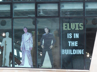
And we were amused to see that Elvis (The King!) was supposedly in a building we passed, but we didn’t enter to see if it was true!
Further on we came to a cruise ship docked — it was the Queen Mary 2.  A luxury cruise liner, but a bit small by today’s standards.  Perhaps that’s not a bad thing, “small is beautiful” so ‘tis said.  Our one trip on a cruise liner, Balmoral, back in 2010 put us off cruise holidays for life — too impersonal because they are so big!

We retraced our steps to Albert Dock, and then continued a bit further because Colin was anxious to visit a ‘real ale’ pub called Baltic Fleet.
We passed a number of narrowboats moored in the dock because, of course, the Leeds to Liverpool Canal has been restored fully and is much used by leisure craft.  We found the pub eventually, and while we were in there we had a bite of lunch at a very reasonable price.
I was anxious to go on the giant Ferris wheel, the Wheel of Liverpool.  It is smaller than the London Eye, but we did go round four times so we felt it was worth it.  Not really much to see, however.  Liverpool was so badly bombed during the War, sixties-type square and characterless buildings have sprung up in every nook and cranny.
It was fun to ride though.
We found a café because we were dying for a cup of tea.  Suitably refreshed, we returned to the shopping area to seek out the famous Cavern Club — where the Beatles rose to fame — and the “Wall of Fame”.

What a load of rubbish!  The whole area has been flattened and completely rebuilt since the sixties, the only remaining artefact being the original door of the Cavern Club.  There it is, looking very out of place in the modern shopping precinct, with the words, “You are here!  Original entrance to the Cavern Club” written along the top.
Enough of this tosh!  Colin wanted to visit another ‘real ale’ pub called the Vernon Arms which was nearby.
On the way we passed a small sculpture of the Beatles — over-rated in my opinion, they were just lucky enough to be in the right place at the right time, when everyone wanted to shake off the shackles of the past and be free!  When we’d “never had it so good”, and changed our hairstyles, our fashions, our manners and our behaviour.  When we wanted to each go our own way and felt we were beholden to nobody.   But as to amazing music — No!  those pop singers of the sixties were popular because they were different, and that is what we wanted at the time.  Having said all that, I quite liked the Beatles music.  Well……most of it.
We found the Vernon Arms, but I’d had enough beer for one day.  Colin said it was much better than the other pub, he was obviously in heaven!  So I sat about until he had sampled two of the many beers on offer.
We made our way back to the bus station.  We popped into Weatherspoon’s for the loo again, and when we came out there was a parade going past.  A lot of drumming and giant puppets — we didn’t know what it was all about but it lent a wonderful atmosphere to the proceedings.  A lovely end to an interesting day!

Saturday, May 18, 2013

Walk 325 -- Southport to Crosby

Ages:  Colin was 71 years and 10 days.  Rosemary was 68 years and 152 days.
Weather:  Grey and dull with a cold breeze.  Drizzle for several hours in the middle.
Location:  Southport to Crosby.
Distance:  16 miles.
Total distance:  3348 miles.
Terrain:  Mostly dunes, some grassy and some soft sand.  Nice woods.  A little road-walking on diversion.  Mostly flat, a little undulating in the dunes.
Tide:  Out, coming in.  Then going out later.
Rivers: No.401, River Alt.
Ferries:  None.
Piers:  None.
Kissing gates:  None.
Pubs:  ‘Freshfield Hotel’ in Formby where Colin drank Peerless ‘Oatmeal Stout’, Timothy Taylor ‘Golden Best’ and Leeds ‘Yorkshire Gold’.  I drank Aspall’s Suffolk Cider.  (We did this the next day when the weather was much improved!)
‘English Heritage’ properties:  None.
Ferris wheels:  None.
Diversions:  No.70 where the footbridge over the River Alt was being ‘reconstructed’, so a long stretch of the footpath was closed.  This cost us one and a half miles in distance, more than half an hour in time, and the diversion was mainly on busy roads.
How we got there and back:  We were staying in our caravan near Southport.  This morning we drove to Crosby where we were able to park for free overlooking the beach where the ‘Iron Men’ are staring out to sea!  We walked inland to the nearest station where we caught a train to Birkdale.  From that station we walked down to the beach where we had finished the last Walk.
At the end we came to the car at the beach car park in Crosby.  We had our tea and biscuits, then drove back to our caravan.
The next day the weather was much improved.  In the morning we wandered around in Formby Woods looking in vain for red squirrels.  The following day we towed our caravan home to Malvern.

About Southport, before we leave it.  Lord Street, the main thoroughfare in the town, is a pleasant wide boulevard.  We came across a plaque put up by the local Civic Society, which told us: 
‘The exiled Prince Louis Napoleon lived in Southport in 1838 and admired the long straight wide tree-lined Lord Street.  Later he remembered Lord Street’s elegance when he returned to France as Emperor, and he transformed Paris with it’s now famous boulevards.” 
He became Napoleon III, of course, and after a long and complicated political history he was exiled to Britain again, a sick and broken man, where he died in 1873.  I have a particular interest in his family because the only school I attended as a child, from the ages of five to seventeen, was Farnborough Hill in Hampshire, previously the home of his widow, the Empress Eugénie.  Next door she built St Michael’s Abbey as a mausoleum for her husband and their son who was killed in the Zulu Wars in South Africa.  She is also buried there in the crypt.  I used to worship there as a child, and loved to listen to the chanting of the monks.
Back to today’s Walk.  It was cold!  Cold!  Cold!  Isn’t it supposed to be Spring? 
Opposite the car park was a roundabout on which there was a sculpture of a horse pulling a shrimping cart.  This reflects the past history of the area.  The practice died out years ago, but there is talk of restoring an old cart which is housed in a redundant museum, attaching a horse and going shrimping in the traditional way “for fun”!
From the car park we followed a path between the dunes and the marsh.  The rare natterjack toad occurs on these marshes, there were notices about them here and there.  Colin found some tadpoles in a rutted pool, and we wondered if they were destined to grow into these scarce and beautiful amphibians.
We have only seen them once in the wild, on the west coast of Ireland.  All we saw here were snails.
We walked across a boardwalk to a further out path where we sat on a log to eat slices of quiche.  We put on our overtrousers because it started to drizzle, then we carried on.  We met a couple with an Alsatian which had a plastic bucket firmly clasped between its teeth — they called him their “bucket-loving dog”.  Colin stopped for a chat about the canine, and after we left them we met no one else until we got to Ainsdale.
The going got a bit squidgy at times, but it wasn’t too bad.  We couldn’t get back across the swamp to the original path which was nearer the shore, but our path improved so we stopped trying.  We crossed a rivulet on a plank bridge, and after that the path got easier.  We could see a round building from a long way off, and made towards that.  Out to sea we could just make out a structure that looked like an oil-drilling platform — in the Irish Sea? 
Ahead we began to see people on the beach, and horses, despite the wind and the rain — and the cold.  We reached Ainsdale at last, and came up the road past a large building with blacked-out windows.
We wondered if it was an ex-hotel — it looked a bit spooky.  We used the temporary toilets, the old ones were being modernised.  At least they were open!  We passed Pontin’s Holiday Camp — it looked very busy in there.  But it was miserable outside.  We came to another roundabout where there was a sculpture, this time of an aeroplane with propellers.
From there we followed a tarmacked cycleway — at least that was our intention until Colin discovered an adjacent path amongst the trees.  We didn’t think it was an official footpath, but when we came to a particularly muddy stretch there were boardwalks for us to tread on.  This path was lovely while it wound through the woods, but it came out into dunes where we were surprised to find three narcissus in flower.  After that it was very up and down with soft sand which was really too much for our ancient legs.  So we gave it up and returned to the cycleway which was lined with bluebells.
Just before we got to the railway, we crossed a busy road and entered Formby Woods.  (We were a mere half-mile from our caravan site at this point.)  These woods are famous for their red squirrels which have managed to hang on here — but we didn’t see any this miserable day.  (Nor the next day when it was much warmer and brighter, and we ‘lost’ ourselves amongst the trees sitting quietly in the hopes they would come out.  They didn’t.)  We sat on a bank under pine trees to eat our sarnies.  The drizzle didn’t reach us there, but the midges did!
We didn’t tarry.  We carried on through the wood — it would have been a lovely walk if the weather hadn’t been so foul.  We tried to follow the yellow arrows all the way because we wanted to walk the official way-marked coast path.  We reached the trail leading out towards the shore, and turned off correctly.  It was nice when we were walking under the trees, but the yellow arrows led us out on to the dunes.
There, without the shelter of the woods, the drizzle became more intense.  The path was very up and down, the sand was too soft to walk in and the wind was cold!
We came to the beach and there was a group of young people, in all that awful weather, having some kind of a party.  They had lit a fire, and there were numerous beer cans strewn about.  I wouldn’t have been surprised if drugs weren’t in use because they looked at us as if we had dropped from another planet.  We were obviously not at all welcome.  All in all, we were really glad to get back amongst the trees.
But…..we couldn’t see any more yellow arrows.  We looked at the OS map, and realised we were the wrong side of a caravan park which we could see beyond the brambles.  We got out a compass, and saw that we were walking north when we should have been walking south.  There was no two ways about it — we were lost!  So we retraced our steps (hate doing that) back to the ‘party’ on the beach — their fire was almost out and the youngsters were standing about miserably in small groups.  So we ignored them, and turned off into the woods a different way.  And there we found the yellow arrows again, we happened upon them by chance.
We came to a picnic area where there was a carving of a bird on a dead tree stump.  We stopped to eat our apples, and to take a silly photo of us pointing in different directions.  We continued, and eventually emerged on to the road to a National Trust car park (where it cost a £5 flat fee to park your car).  We went out into the open looking for the continuation of the path to the south, it was wet and cold out there.  We had difficulty finding the way on, it was different to the OS map, or perhaps we were just too cold to read it properly.  But we found the path in the end — there was a notice about a permit which we ignored.
Back in the dunes, we immediately got lost again!  Dunes can be so confusing because they all look the same and walking is tricky with the soft sand and deeply undulating terrain.  We didn’t know which way to turn, but came across a yellow arrow again where we were least expecting it.  (It seemed to be hidden away as if to trick us.)  We went wrong twice more because of the lack of yellow arrows, but then we happened upon a decent path going southwards so we put on a pace.  It was a pity about the rain and cold.  (Is it really Spring?)
Our OS map said the Coastal Way turns inland before Lifeboat Road, but in reality it didn’t.  There was a huge car park at the end of the road which cost £4.50 to enter in a car, but there was no one collecting money on this wet and cold Saturday afternoon in May.  We walked the length of Lifeboat Road, then turned right along a private road which was a bit potholey.  We followed this past houses and a school, then it turned into a track but was still good walking.  The drizzle actually stopped, but it remained cold and grey.
We reached a military range where we could hear them shooting.  We had to turn almost back on ourselves, north-east, in order to get round it.  We reached the point where the path turned south again only to find that our way was barred by security fencing.  A notice told us that the footbridge over the River Alt was being “reconstructed” and therefore there was “no through route for pedestrians”.  We were that tired and cold by then, we both swore loudly!  We studied the map and worked out that the diversion added one and a half miles to our Walk, and involved walking alongside busy roads.  If we’d been told earlier we could have taken a more diagonal route through Formby village and saved a lot of that extra mileage.
Another notice behind the fence claimed it was MOD land so “Keep Out”, but according to our OS map we were well past the firing range so we didn’t understand why that notice was there.  We were both quite angry that the coastal path was blocked in such a way, it’s no encouragement for people to go out walking.  We could have squeezed through a gap in the fencing, and Colin was all for doing this and going on to see if the bridge was really impossible to cross.  I was against it for two reasons — I didn’t want to have to retrace my steps for the second time today, and even if we did manage to clamber across a broken bridge we might well have to walk a good mile before we reached the security fencing at the other end of the banned path.  If that was really secure and we couldn’t get through it, then our diversion would be an extra three and a half miles!  (I had studied the map carefully, Colin had only given it a cursory glance.)
As usual, Colin took some persuading, and he only calmed down on the discovery of a nest of duck’s eggs in the grass beside the path, which had become a cycleway by now.
We continued in a north-easterly direction, crossing the railway and on into housing estates.  Then we had to walk along a very busy B road that had an extremely narrow pavement which hardly kept us off the road.  At last we reached the main road where we were able to turn south and cross the river on the road bridge.  We were relieved to find there was a pavement behind a grass verge so we were well back from the traffic — just as well because it was fast, noisy and relentless.
We continued for another mile before we could turn off into the village of Hightown.  There we had to don our bright yellow waistcoats because the road into the village, though quieter, had no pavements and no verges even.  There was nowhere to go whenever a vehicle went by.  We crossed the railway on a high bridge.  We did consider using the seats on the station platform to sit down and eat our chocolate, but the station was down there, we were up here, and in the end we couldn’t be bothered.
We came to a roundabout on which there was a War Memorial.  A girl, talking on her mobile, was sitting on the one and only bench we came across.  But she got up and walked away as we approached, so we sat down and ate our chocolate.  All the while — about twenty minutes — the girl was pacing up and down a nearby pavement talking animatedly into her phone which she clutched to her ear.  How did we manage our lives before they had been invented? 
We continued until we reached the seafront.  We turned left — and there were the yellow arrows again!  We hadn’t seen any since the path that was barred to us.  We were the correct side of the River Alt, the correct side of the railway, and out to sea we could just make out a huge windfarm.  The river was beside us because it sticks to the coast for about one and a half miles. 
The path started off well, but before long we entered the dunes.  We hate dunes!  There were lots of ups and downs, soft sand and branching paths.  We followed the yellow arrows more by luck than by judgement.  Then we lost them!  We couldn’t believe that we had missed our way on this Walk again!  We didn’t know where we were, we just followed our noses and hoped they were taking us in the right direction.  It was not easy walking — dunes are not difficult to get lost in.  We considered walking along the beach, so we turned in that direction.  But it proved to be too squidgy and rocky, so we went back into the dunes.
However, by then the top had opened up and there was now a good clear path all the way to Crosby Beach.  We could see Liverpool ahead, and the mountains of Wales a little over to our right.  We watched a container ship go out from Liverpool.  We arrived in the car park at Crosby, where our car was waiting for us.

That ended Walk no.325, we shall pick up Walk no.326 on Crosby Beach.   It was eight o’clock, so the Walk had taken us nine hours.
While we were enjoying our tea and biscuits, we were looking at Anthony Gormley’s interesting sculpture “Another Place”.  It is a hundred life-size copies of his own naked body standing on the beach staring out to sea.  Some of them are high up on the shore, others were already in the water because the tide was coming in.
A large cruise ship came out of Liverpool and sailed away to warmer climes.  It was so close in to shore it didn’t look as if the water was deep enough!  We also got the impression, in our tiredness and relief at completing the Walk, that some of the metal figures were waving to the ship whilst trying to wade out to it shouting, “Wait for me!”
With these flights of fancy in mind — we drove back to our caravan between Southport and Formby.
The next day the weather was much improved.  In the morning we wandered around in Formby Woods looking in vain for red squirrels.  Then we went to the pub.  The following day we towed our caravan home to Malvern.

Thursday, May 16, 2013

Walk 324 -- Hesketh Bank to Southport

Ages:  Colin was 71 years and 8 days.  Rosemary was 68 years and 150 days.
Weather:  Mostly sunny.  Cool breeze but NO WIND!  Slight rain in the middle of the Walk.
Location:  Hesketh Bank to Southport.
Distance:  15 miles.
Total distance:  3332 miles.
Terrain:  Mostly grassy/muddy river banks.  Some tarmac/concrete.  Some marsh/beach.  Flat.
Tide:  Coming in, later going out.
Rivers: No.400, Three Pools Waterway.
Ferries:  None.
Piers:  No.33, Southport — but it was closed because we reached it too late in the day.
Kissing gates:  Nos.416, 417, 418, 419, 420 & 421 on the river banks.
Pubs:  None.
‘English Heritage’ properties:  None.
Ferris wheels:  No.10 in Southport, but it was not running.
Diversions:  None.
How we got there and back:  We were staying in our caravan near Southport.  This morning we drove to a beach car park a little to the south of Southport.  From there we walked to Lord Street where we caught a bus to Hesketh Bank.  We alighted at the church, and walked down the road to the boatyard where we finished the last Walk.
At the end we came to the car on the beach.  We drove straight back to the caravan to have our tea in comfort because it wasn’t far.

No wind!  No rain!  It was wonderful!  We noticed a chapel up above the boatyard at Hesketh Bank as we passed through, but we didn’t try to visit it as we hadn’t time with a long Walk ahead of us.  We had difficulty finding our way out of the boatyard at the northern end — there were no signs even though we were on a public footpath.  In the end we found a gate with a yellow arrow on it tucked away round a corner.  We came out on the river bank opposite where we walked two days ago.  But this time it was different — instead of battling against a strong wind, we walked along in a gentle breeze.
We hiked about a mile before we sat on the bank to eat our pasty/quiche.  The only person we met was a man with a wet dog — it had been enjoying a swim in the river.  We carried on for miles towards the River Ribble.  We seemed to be walking towards Warton Aerodrome which we had passed on the Walk before last.  It reminded us of those tedious Essex marshes again.  Even the neat furrows in an adjacent field made us think we were back in the Fens.
We came to where the public footpath turned westwards on to an inner bank.  There was a notice tied to the stile which told us that the footpath was closed for the next one and a half miles in the interests of public safety because of trial borings they were making in the soil.  The path ahead was very flat and straight, so we could see a long way.  As we couldn’t see anything happening ahead, we climbed over the stile and carried on.  Nothing was happening ahead, and we saw no more such notices at any of the access points nor at the end of the one and a half miles!  However there was a concrete bar along the middle of the path (it had been there a long time so was nothing to do with the trial borings) which made walking tricky along this stretch.  We met a second man, he was accompanied by a dry dog.
We came to a car park with an old buoy at the entrance.  Up on the bank ahead was a RSBP shelter with benches in it — this proved to be a lovely comfortable place to sit and eat our sarnies.  It was overlooking the marshes where there were several pools.  We saw a few ducks, but not many other kinds of birds.
We continued, and got to the end of the long straight path where the public footpath turned inland to the road.  It looked as if we could continue straight on and link up with another sea bank a quarter of a mile away, but nothing was marked on the map.  We decided to be ‘good’ and divert inland, I was in no mood for Right-of-Way confrontations, ditches or barbed wire.  (It was a bum decision, and we wished later we’d just gone for it.)  It was a mile to the road and another mile out again on a parallel track a mere hundred yards away.
We accessed the road through an avenue of poplar trees, which have always been my favourite tree — I just love the shape.  We also passed a field that was entirely covered in polythene — what is the countryside coming to?  The road was busy and the traffic fast, even though it is a back road.  It had no pavements, we just had to dodge.  Fortunately it wasn’t far.  The private road back to Marsh Farm was busier than we had anticipated, with agricultural vehicles bearing down on us and cars kicking up a dust.  We would have been much more out of the way scooting along the sea bank — how we wished we’d done that!  There was mass planting in progress on the neat fields — this is not the countryside, it’s a factory! 
We passed Marsh Farm and went across a field to a stile.  There we put on our full wet-weather gear because it had started to rain, but it didn’t really come to much.  Over the stile we had to scramble straight up the steep seabank, there was no path.  At the top we realised that if we’d been walking the coast the other way we’d never have seen that stile and would have continued walking until we met the other seabank.  That is when we really wished we’d done just that and missed out the road bit.  Hindsight is a wonderful thing!
The top of the bank was very muddy because cattle had been up there and churned it up.  We passed some sheep with curly horns.  We also passed a dead cow lying on the edge of the marsh.  While we were wondering who we should inform, the farmer came along with his tractor to scoop it up.  So he already knew about it — I wonder why it died.
It was muddy all the way to Old Hollow Farm, and beyond.  It was difficult walking so we went down on to the edge of the marsh, but it wasn’t much better there.  After a while I climbed back up again because it was too uneven.  It was still muddy on top, but less so than further back.  We came to a stile, and it was grassy and smooth the other side — at last!  We sat on the stile to eat our apples.  We removed our wet-weather gear as the sun was once again shining.
It was much easier walking from thereon, and we could see the road.  We met a woman with a dog, she was only the third person we had met since starting this morning.  We crossed the creek at Fiddler’s Ferry — now we were in Merseyside, no longer in Lancashire.
We passed a huge granite rock on display.  Granite?  In this flat fen-like area?  A notice told us that it was dug out of the ground in 1959 when they were building a pumping station.  It is Criffel Granite — but Criffel was miles back in Dumfries & Galloway!  They concluded that it was brought here by ice, 18000 years ago.  It is an ‘erratic’.  It just shows the power of the ice, and how huge the glaciers must have been.  Mind boggling!
There was a cycleway alongside the creek behind the houses, so we didn’t have to walk along the road as our map indicated.  There was apple-blossom in the hedge to our left, and wading birds in the creek to our right.  Walking was very easy, and we felt a lot more relaxed as we approached Southport.  At the mouth of the creek the cycleway continued beside a road until we reached a car park.  Between us and the houses was a wide marshy area with ponds.  We sat on a bank to eat our chocolate.  We could see Southport Pier ahead, and if we looked through our telescope/binoculars we could see Blackpool Tower behind.
The path continued along the top of the marsh — it reminded us of Grange-over-Sands where there is marsh-grass instead of sand and sea.  The sun was now bright in a cloudless sky.  A bit too bright as it happened, because it was setting in a low sky at that time of day making photography difficult.  It got squidgy underfoot so we went up on the prom.  Then the marsh gave way to firm sand, so we went back down again.  In places there were patches of crushed shells on the beach.
We reached the pier and could see men doing press-ups on the beach just beyond it.  We climbed up some steps on to the pier, but the sea end was closed with a stark warning notice — we were too late in the day.
We were actually halfway along the pier on the seafront where we were standing.  The construction starts on the edge of town across the marsh, which here has been converted into marine lakes.
Yesterday, on our ‘rest’ day, we walked the shore half which is open all the time.  We thought we’d leave the sea half to today when we were on our Walk, but they closed it too early.
We continued along the prom.  The athletes were doing jump-ups on to the wall, then they all ran past us on the beach.  We wondered what event they were training for.  We passed a fairground on the marshes — free to enter, unlike Blackpool.
It had a small Ferris wheel, but none of the rides were open when we passed.  Colin remembered going to that fairground as a child when he was holidaying in Blackpool with his parents, but his memories were of a much more exciting place than it appeared to be today.  (Possibly he was remembering through rose-tinted spectacles…..?)

We passed a post marking the end, or the beginning, of the Trans-Pennine Trail.  We came across the other end of this in Hornsea when we were walking the Yorkshire coast back in 2005.  It is a cycle trail across the country, but it can be walked as well.  Colin pointed out Chesterfield, the town of his birth, marked on the post.

We continued along the lower prom which was just above the sand.  Then the marsh grass started again, it seems the bare sand is only for about half a mile either side of the pier.  We followed a path along the top of the marsh to the second roundabout where our car was parked in a free car park — probably considered too far out of town to be worth bothering with charges.  In the distance we could see the Welsh mountains — nearly there!
That ended Walk no.324, we shall pick up Walk no.325 at the second roundabout just south of Southport.   It was twenty-five past seven, so the Walk had taken us eight and a quarter hours.  We drove straight back to the caravan to have our tea in comfort because it wasn’t far.