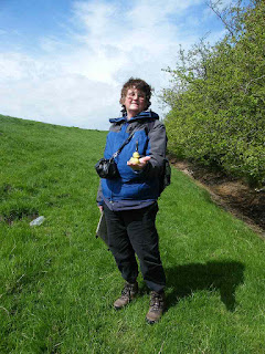
Weather: Strong cold wind, but mainly dry.
Location: Preston to Hesketh Bank.
Distance: 13 miles.
Total distance: 3317 miles.
Terrain: Mostly grassy river banks. A little pavement-bashing. Flat.
Tide: Coming in, then going out.
Rivers: No.398, River Ribble. No.399, River Douglas.
Ferries: None.
Piers: None.
Kissing gates: Nos.413, 414, & 415 on the banks of the Ribble.
Pubs: None.
‘English Heritage’ properties: None.
Ferris wheels: None.
Diversions: None.
How we got there and back: We were staying in our caravan near Southport. This morning we drove to the village of Hesketh Bank where we parked in a road behind the church. In front of the church we caught a bus to Preston, and alighted as soon as we crossed the river. It was only a short walk to the place where we finished the last Walk.
At the end we walked up from the boatyard to the church where our car was parked. We had our tea & biscuits, then drove back to the caravan site.
It was wonderful that we were able to complete today’s Walk without donning our wet-weather gear — in fact we walked mostly in brilliant sunshine. But “Oh!” the wind! It hasn’t abated one scrap, making it very difficult for us to walk with it in our faces. Unfortunately that was the way we had to hike for most of today.

 We crossed the River Ribble at the second bridging
point, as the first was inaccessible. We
immediately turned right into a car park, then on to the riverside walk which
was set out as a park for the first half mile.
We walked under the inaccessible first bridge which seems to be a modern
flyover for traffic only. We sat on the
last seats in the park to eat our pasties.
We crossed the River Ribble at the second bridging
point, as the first was inaccessible. We
immediately turned right into a car park, then on to the riverside walk which
was set out as a park for the first half mile.
We walked under the inaccessible first bridge which seems to be a modern
flyover for traffic only. We sat on the
last seats in the park to eat our pasties.
 Out of the park, we passed lots of pylons amongst
trees. It was very noisy! We thought, at first, it was a car-crunching
machine we could hear. But when we rounded
a bit of a corner we saw that it was a tree-crunching machine! Loud! Workmen were clearing the trees next to the
pylons — I suppose the two don’t go well together, and could be a fire hazard.
Out of the park, we passed lots of pylons amongst
trees. It was very noisy! We thought, at first, it was a car-crunching
machine we could hear. But when we rounded
a bit of a corner we saw that it was a tree-crunching machine! Loud! Workmen were clearing the trees next to the
pylons — I suppose the two don’t go well together, and could be a fire hazard.
 We moved out into the open, it was still a good
path. It was very windy with the gusts
blowing straight into our faces. It was
hard work getting along. The wind made a
eerie humming noise as it blew through the wires of the pylons, of which there
were many. We were glad to get past them
all and away from that irritating buzz.
We moved out into the open, it was still a good
path. It was very windy with the gusts
blowing straight into our faces. It was
hard work getting along. The wind made a
eerie humming noise as it blew through the wires of the pylons, of which there
were many. We were glad to get past them
all and away from that irritating buzz.
We passed the entrance to Preston Docks on the opposite bank of the river.
 Further on a
notice told us that the footpath to Penwortham was closed because of
“works”. We thought it was some kind of
water drainage treatment works — they were doing a bit of digging but we
couldn’t see that it got in the way of the footpath. (‘Elfin Safety’ regulations, I suspect.) But it didn’t affect us because the riverside
path was still open, so we carried on.
Further on a
notice told us that the footpath to Penwortham was closed because of
“works”. We thought it was some kind of
water drainage treatment works — they were doing a bit of digging but we
couldn’t see that it got in the way of the footpath. (‘Elfin Safety’ regulations, I suspect.) But it didn’t affect us because the riverside
path was still open, so we carried on.
 We came to a stile in the middle of nowhere! It was just by itself, no fence or other
barrier to get past. It even had a
yellow arrow on it, and a signpost telling us it was the “Ribble Way, to The Dolphin” whatever that
was. Colin climbed over it because it
was there — I didn’t bother. We were
relieved we didn’t have to divert inland for a quarter of a mile to cross a
stream, as was indicated on our map. The
main river bank was so built up, the stream culverted underneath, that we
hardly noticed it.
We came to a stile in the middle of nowhere! It was just by itself, no fence or other
barrier to get past. It even had a
yellow arrow on it, and a signpost telling us it was the “Ribble Way, to The Dolphin” whatever that
was. Colin climbed over it because it
was there — I didn’t bother. We were
relieved we didn’t have to divert inland for a quarter of a mile to cross a
stream, as was indicated on our map. The
main river bank was so built up, the stream culverted underneath, that we
hardly noticed it.
 Colin walked up by the river because “the view was
better”. I stayed down next to a scrabby
hedge where it was marginally less blowy.
We both noticed what looked like white petals blowing towards us very
fast. They kept coming in ever greater
numbers, and we realised it was something more substantial. They were moving so fast it was difficult to
see what they were, but eventually we realised they were tiny pieces of
expanded polystyrene! They came in their
thousands, quite a snowstorm. It was
surreal! In the end they lessened, and then
there were no more. We don’t know where
they came from, there were only sheep ahead.
And goodness knows where they ended up!
Not very good for the environment.
Colin walked up by the river because “the view was
better”. I stayed down next to a scrabby
hedge where it was marginally less blowy.
We both noticed what looked like white petals blowing towards us very
fast. They kept coming in ever greater
numbers, and we realised it was something more substantial. They were moving so fast it was difficult to
see what they were, but eventually we realised they were tiny pieces of
expanded polystyrene! They came in their
thousands, quite a snowstorm. It was
surreal! In the end they lessened, and then
there were no more. We don’t know where
they came from, there were only sheep ahead.
And goodness knows where they ended up!
Not very good for the environment.
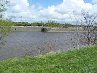
 We were watching the action of the river. The tide was coming in and the current was
flowing out. The wind was blowing in
from the sea making waves which made it look as if that direction was
winning. But a large piece of plastic
appeared and floated very slowly outwards.
It made us realise that the outflowing current was just about dominant —
but it was all much of an optical illusion.
We were watching the action of the river. The tide was coming in and the current was
flowing out. The wind was blowing in
from the sea making waves which made it look as if that direction was
winning. But a large piece of plastic
appeared and floated very slowly outwards.
It made us realise that the outflowing current was just about dominant —
but it was all much of an optical illusion.
 We came to a bend in the path where we had to turn
inland — there were only marshes ahead. Further
on there was a tributary of the River Ribble, the River Douglas, which we had
to follow for five miles before we could cross it. Then it would be five miles back to the
Ribble and a further two miles to the coast.
(We began to have flashbacks of the ‘jigsaw’ pattern we had to walk ten
years ago round those tedious Essex
marshes!) The wind was now blowing in
from our right, so strong it was difficult to stand up. We scrambled down the left-hand side of the
bank and walked along the bottom. What a
difference — it was almost pleasant!
We came to a bend in the path where we had to turn
inland — there were only marshes ahead. Further
on there was a tributary of the River Ribble, the River Douglas, which we had
to follow for five miles before we could cross it. Then it would be five miles back to the
Ribble and a further two miles to the coast.
(We began to have flashbacks of the ‘jigsaw’ pattern we had to walk ten
years ago round those tedious Essex
marshes!) The wind was now blowing in
from our right, so strong it was difficult to stand up. We scrambled down the left-hand side of the
bank and walked along the bottom. What a
difference — it was almost pleasant!
 I
even found a toy duck down there sheltering from the wind! Further on we sat on this sheltered side of
the bank to eat our sarnies. We idly
watched some workers in the distance doing sand extraction — then they packed
up and went for lunch too.
I
even found a toy duck down there sheltering from the wind! Further on we sat on this sheltered side of
the bank to eat our sarnies. We idly
watched some workers in the distance doing sand extraction — then they packed
up and went for lunch too.
The next mile was through farmer’s fields — boring! I consider farmland to be food factories in rural settings, not the true countryside. It is all so unnatural with its monoculture. One field we walked through was half a mile long, a single field! We knew we were no longer in Scotland by the number of Private Land — Keep Out notices we passed.
We were back on the seabank again, or more correctly the river bank because we were now well inland, trudging away from the coast along the River Douglas. We found we were walking into the wind, so once again we scrambled down the side of the bank and walked along the bottom.
We came to the end of the bank, and that is where we got a bit lost. The public footpath had been diverted along a new bit of bank, but that wasn’t marked on the map even though we had only recently bought it. (Usual story with the Ordnance Survey) We tried to follow the map. We crossed a footbridge and thought we were OK. But we found ourselves ‘trapped’ in a field surrounded by deep drainage ditches and being forced to walk in completely the wrong direction. We retraced our steps to the footbridge, and this time followed the public footpath sign (which we originally thought had got twisted) which pointed us towards the new seabank.
Round a bend and only about three hundred yards further on, the bank ended. There we were left in the lurch. Where to go? There were no signs and no obvious paths. According to our map we were on private land. We followed our noses, scrambled up the side of a field, then over a stile into a newly planted orchard. There were no footpath signs, but we realised we were now where we should be according to the map. After that the signs were better, though we had to climb over a locked gate at one point.
 We came to a disused railway line, it was up on a
bank. And there was a ‘Lancashire Coastal Way’
signpost, the first we had seen since several miles before Preston! Where had the Way gone in between? We had a choice of routes here, each side of
a cabbage field — either follow the river bank or the railway bank. We should have followed the river bank if we
were pernickety about the rules, but the railway bank was shorter, and more
sheltered if we walked along the bottom of it.
We came to a disused railway line, it was up on a
bank. And there was a ‘Lancashire Coastal Way’
signpost, the first we had seen since several miles before Preston! Where had the Way gone in between? We had a choice of routes here, each side of
a cabbage field — either follow the river bank or the railway bank. We should have followed the river bank if we
were pernickety about the rules, but the railway bank was shorter, and more
sheltered if we walked along the bottom of it.
 So the railway bank won, after we’d sat on the lee side of it to eat our
chocolate. (We were miles inland by now
anyway, so the rule was to get back to the sea by the shortest route possible —
additional rule no.11.) We were rewarded
by spying a clump of bluebells in the undergrowth.
So the railway bank won, after we’d sat on the lee side of it to eat our
chocolate. (We were miles inland by now
anyway, so the rule was to get back to the sea by the shortest route possible —
additional rule no.11.) We were rewarded
by spying a clump of bluebells in the undergrowth.
 The routes very soon joined up, we were back on the
river bank opposite Hesketh Bank where our car was parked. We would have been there in five minutes if
we could have flown/swum/sailed across the river. But we couldn’t, so we still had three miles
to go. Now we were several miles inland
we were a little more sheltered from the wind, so walking was more pleasant.
The routes very soon joined up, we were back on the
river bank opposite Hesketh Bank where our car was parked. We would have been there in five minutes if
we could have flown/swum/sailed across the river. But we couldn’t, so we still had three miles
to go. Now we were several miles inland
we were a little more sheltered from the wind, so walking was more pleasant.
 We could see, on the other side of the river, a
place where the bank had caved in. It
looked very muddy there.
We could see, on the other side of the river, a
place where the bank had caved in. It
looked very muddy there.
 We also passed
some geese pecking away for morsels on the opposite bank. Next we passed a lock leading into a canal,
also on the other side of the river which then took a sharp left hand
turn.
We also passed
some geese pecking away for morsels on the opposite bank. Next we passed a lock leading into a canal,
also on the other side of the river which then took a sharp left hand
turn.
 The path soon led us away from the
river bank and spilled us out on to a main road. We still had a mile to go before we reached
the bridge. The road was extremely busy, but we crossed to a
pavement so at least we didn’t have to dodge traffic. Eventually we reached Tarleton Bridge
which took us across the river, then across the canal which was running
parallel to it at this point. It is a
branch of the Leeds &
Liverpool Canal
which runs northwards to Tarleton Lock allowing access to the River Douglas,
and thence to the River Ribble. We
thought we would have to continue along the road and then walk through the village of Tarleton before we returned to the river
bank because there were no footpaths marked on the OS map. But as we crossed the bridge, Colin said, “If
this is a canal, it must have a
towpath!” He was right! Uneven steps led down from the canal bridge
and underneath it, then onwards towards Hesketh Bank.
The path soon led us away from the
river bank and spilled us out on to a main road. We still had a mile to go before we reached
the bridge. The road was extremely busy, but we crossed to a
pavement so at least we didn’t have to dodge traffic. Eventually we reached Tarleton Bridge
which took us across the river, then across the canal which was running
parallel to it at this point. It is a
branch of the Leeds &
Liverpool Canal
which runs northwards to Tarleton Lock allowing access to the River Douglas,
and thence to the River Ribble. We
thought we would have to continue along the road and then walk through the village of Tarleton before we returned to the river
bank because there were no footpaths marked on the OS map. But as we crossed the bridge, Colin said, “If
this is a canal, it must have a
towpath!” He was right! Uneven steps led down from the canal bridge
and underneath it, then onwards towards Hesketh Bank.

 It was really pleasant walking along that
towpath. It was sheltered from the wind
and the sun was shining. We passed quite
a few boats moored at the side of the canal.
Colin said, “This is the most interesting part of the Walk so far!” And I agreed with him. We came to the lock at the end of the canal which
we had seen earlier from the other bank of the river.
It was really pleasant walking along that
towpath. It was sheltered from the wind
and the sun was shining. We passed quite
a few boats moored at the side of the canal.
Colin said, “This is the most interesting part of the Walk so far!” And I agreed with him. We came to the lock at the end of the canal which
we had seen earlier from the other bank of the river.
 The path led us through an iron gate with a
lock on it, but it was undone so we were able to pass through OK. (The path we had just walked from the bridge
was not marked on the OS map.) The
public footpath came in from the village at that point, and there were two
benches we could have sat on — but we didn’t because we only had another mile
to go.
The path led us through an iron gate with a
lock on it, but it was undone so we were able to pass through OK. (The path we had just walked from the bridge
was not marked on the OS map.) The
public footpath came in from the village at that point, and there were two
benches we could have sat on — but we didn’t because we only had another mile
to go.
 We had to walk through a farmyard. It was too muddy, so we tried to avoid it by
going down near the river. Even there we
had to jump from tuft of grass to tuft of grass because cattle had been there
and churned it up with their feet. The
path was muddy in patches for the rest of the Walk, we think the river had
recently flooded over it.
We had to walk through a farmyard. It was too muddy, so we tried to avoid it by
going down near the river. Even there we
had to jump from tuft of grass to tuft of grass because cattle had been there
and churned it up with their feet. The
path was muddy in patches for the rest of the Walk, we think the river had
recently flooded over it.
 We passed the
geese, still pecking the mud for morsels, and we passed the place where the
bank had caved in. That was a very muddy
patch.
We passed the
geese, still pecking the mud for morsels, and we passed the place where the
bank had caved in. That was a very muddy
patch.
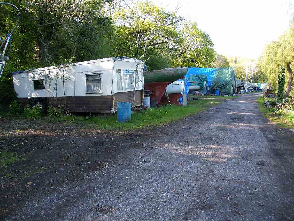
 Eventually we walked up through
the boatyard at Hesketh Bank, with caravans dispersed between the boats.
Eventually we walked up through
the boatyard at Hesketh Bank, with caravans dispersed between the boats.
 Smile
! You’re on
CCTV !
Smile
! You’re on
CCTV !
 That ended Walk no.323, we shall pick up Walk no.324 in the boatyard at
Hesketh Bank. It was quarter past six,
so the Walk had taken us seven and three-quarter hours. We walked up from the boatyard to the church
where our car was parked. We had our tea
and biscuits, then drove back to the caravan site.
That ended Walk no.323, we shall pick up Walk no.324 in the boatyard at
Hesketh Bank. It was quarter past six,
so the Walk had taken us seven and three-quarter hours. We walked up from the boatyard to the church
where our car was parked. We had our tea
and biscuits, then drove back to the caravan site.
Location: Preston to Hesketh Bank.
Distance: 13 miles.
Total distance: 3317 miles.
Terrain: Mostly grassy river banks. A little pavement-bashing. Flat.
Tide: Coming in, then going out.
Rivers: No.398, River Ribble. No.399, River Douglas.
Ferries: None.
Piers: None.
Kissing gates: Nos.413, 414, & 415 on the banks of the Ribble.
Pubs: None.
‘English Heritage’ properties: None.
Ferris wheels: None.
Diversions: None.
How we got there and back: We were staying in our caravan near Southport. This morning we drove to the village of Hesketh Bank where we parked in a road behind the church. In front of the church we caught a bus to Preston, and alighted as soon as we crossed the river. It was only a short walk to the place where we finished the last Walk.
At the end we walked up from the boatyard to the church where our car was parked. We had our tea & biscuits, then drove back to the caravan site.
It was wonderful that we were able to complete today’s Walk without donning our wet-weather gear — in fact we walked mostly in brilliant sunshine. But “Oh!” the wind! It hasn’t abated one scrap, making it very difficult for us to walk with it in our faces. Unfortunately that was the way we had to hike for most of today.


We passed the entrance to Preston Docks on the opposite bank of the river.


The next mile was through farmer’s fields — boring! I consider farmland to be food factories in rural settings, not the true countryside. It is all so unnatural with its monoculture. One field we walked through was half a mile long, a single field! We knew we were no longer in Scotland by the number of Private Land — Keep Out notices we passed.
We were back on the seabank again, or more correctly the river bank because we were now well inland, trudging away from the coast along the River Douglas. We found we were walking into the wind, so once again we scrambled down the side of the bank and walked along the bottom.
We came to the end of the bank, and that is where we got a bit lost. The public footpath had been diverted along a new bit of bank, but that wasn’t marked on the map even though we had only recently bought it. (Usual story with the Ordnance Survey) We tried to follow the map. We crossed a footbridge and thought we were OK. But we found ourselves ‘trapped’ in a field surrounded by deep drainage ditches and being forced to walk in completely the wrong direction. We retraced our steps to the footbridge, and this time followed the public footpath sign (which we originally thought had got twisted) which pointed us towards the new seabank.
Round a bend and only about three hundred yards further on, the bank ended. There we were left in the lurch. Where to go? There were no signs and no obvious paths. According to our map we were on private land. We followed our noses, scrambled up the side of a field, then over a stile into a newly planted orchard. There were no footpath signs, but we realised we were now where we should be according to the map. After that the signs were better, though we had to climb over a locked gate at one point.


No comments:
Post a Comment