Weather: Wet, windy and cold to start with, turning
sunny and warmer but still windy.
Location: Lytham St Anne’s to Preston.
Distance: 12 miles.
Total distance: 3304 miles.
Terrain: Grassy paths. Muddy paths. Pavements and cycleways. Flat.
Tide: In, going out.
Rivers: No.396, Pool Stream. No.397, Savick Brook.
Ferries: None.
Piers: None.
Kissing gates: Nos.407, 408, 409, & 410 around the aerodrome. Nos. 411 & 412 further on.
Pubs: None.
‘English Heritage’ properties: None.
Ferris wheels: None.
Diversions: None.
How we got there and back: We were staying in our caravan in Blackpool. This morning we drove almost into Preston where we parked near the old dockland area which has now been turned into a retail park. In the teeming rain we walked half a mile to a bus stop where we were able to catch a bus to Lytham St Anne’s. We alighted a short distance from where we finished the last Walk.
At the end we walked back to the car, had our tea & biscuits, then drove back to the caravan site.
The next day we towed our caravan to a site just south of Southport, adjacent to Formby Nature Reserve. It was a much more sheltered site, and we were able to put our awning up at last.
We started this Walk in the wind and rain — it was very depressing. The track where we finished the last Walk led to a bank alongside a muddy creek. It wasn’t very pretty. We passed through some dripping trees, then walked alongside the fence of a boatyard. We sat on a bank in the rain and gloomily ate our pasties. The path led on between two fences to the road where we crossed another creek on a bridge.
 We immediately left the road again to walk alongside
the second creek — this one was a bit prettier because it had small leisure
boats moored on the opposite bank. We
veered away from the creek on to a good path on the edge of a marsh. It was up on a bank and fairly dry underfoot,
which was something of a miracle considering how much rain we have had over the
last few days.
We immediately left the road again to walk alongside
the second creek — this one was a bit prettier because it had small leisure
boats moored on the opposite bank. We
veered away from the creek on to a good path on the edge of a marsh. It was up on a bank and fairly dry underfoot,
which was something of a miracle considering how much rain we have had over the
last few days.
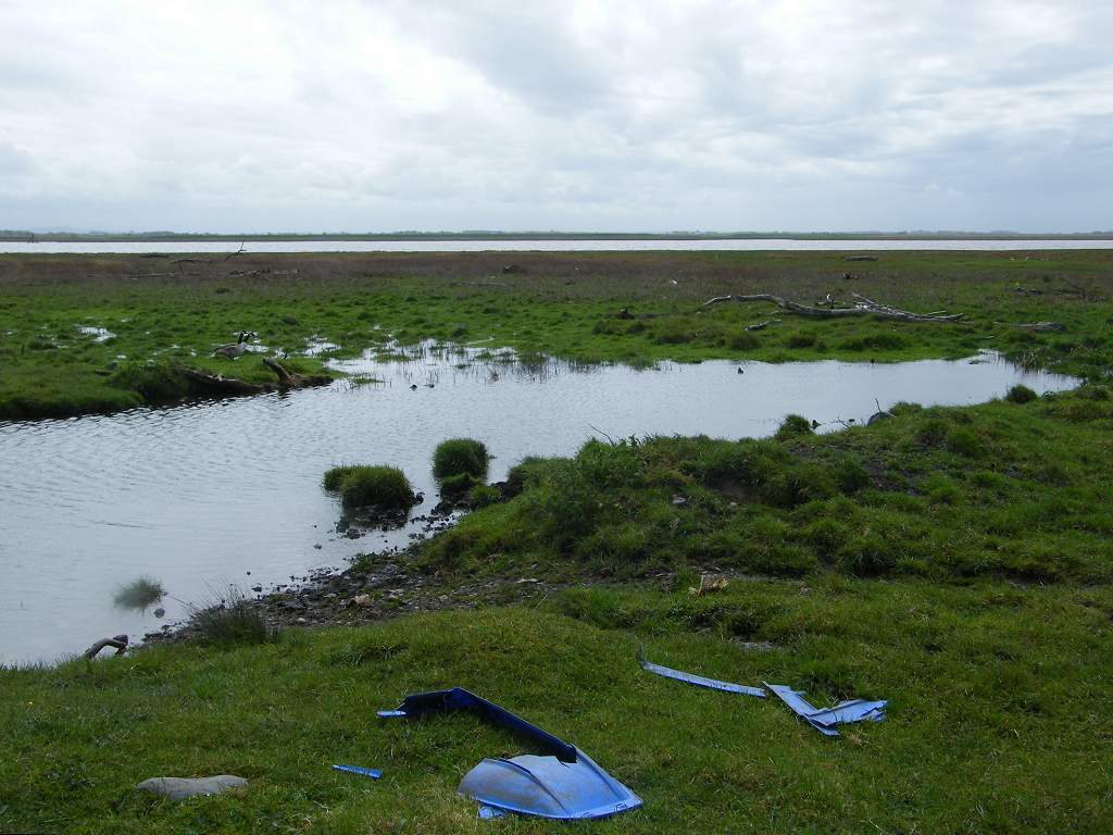
 But we were shocked by
the amount of rubbish that had been washed up — big things including a child’s
toy ride-in Landrover! The tide only
occasionally washes up to the bank, so it shows what a dustbin the sea has
become.
But we were shocked by
the amount of rubbish that had been washed up — big things including a child’s
toy ride-in Landrover! The tide only
occasionally washes up to the bank, so it shows what a dustbin the sea has
become.
 We came to the next creek, and this one had a grass
covered bridge across it. But barring
our way was a gate fastened with twisted barbed wire! A yellow arrow directing us through the gate
had been partially scratched out, and there was a notice which said, “Private. No access.” Except that the word “No” had a block over it
which had been moved sideways so that it was no longer obscuring the word. There were two more gates, each done up in
the same way, on the twenty yard crossing of this creek. We concluded that there must be a right of
way dispute with the landowner. The road
wasn’t far away, and not wishing to attack the barbed wire with our bare hands
we went out to the road and back the other side of the creek along a farm
driveway, passing right in front of the farmhouse. We thought it was a ridiculous
situation. You would think the landowner
would prefer walkers to be well out
of the way on the bank instead of walking up their drive and under their
windows! But some people can be very
obstinate when sticking to their principles.
According to the OS map, the right of way is the route we took out to the road and not the twenty yards along
the bank; probably because, when the footpath was established many moons ago, the
grass covered bridge didn’t exist.
We came to the next creek, and this one had a grass
covered bridge across it. But barring
our way was a gate fastened with twisted barbed wire! A yellow arrow directing us through the gate
had been partially scratched out, and there was a notice which said, “Private. No access.” Except that the word “No” had a block over it
which had been moved sideways so that it was no longer obscuring the word. There were two more gates, each done up in
the same way, on the twenty yard crossing of this creek. We concluded that there must be a right of
way dispute with the landowner. The road
wasn’t far away, and not wishing to attack the barbed wire with our bare hands
we went out to the road and back the other side of the creek along a farm
driveway, passing right in front of the farmhouse. We thought it was a ridiculous
situation. You would think the landowner
would prefer walkers to be well out
of the way on the bank instead of walking up their drive and under their
windows! But some people can be very
obstinate when sticking to their principles.
According to the OS map, the right of way is the route we took out to the road and not the twenty yards along
the bank; probably because, when the footpath was established many moons ago, the
grass covered bridge didn’t exist.
Part of the next bank was mown grass! But that ran out as soon as we’d passed some houses — paths like that never last very long. For the next few miles we were walking along the perimeter fence of Warton Aerodrome, still very much in use. We walked into a field with some cows, and the younger ones came galloping towards us. But we ignored them or said “Boo!” if they got too close, and they soon lost interest. Sheep we would have inadvertently herded, but cows don’t behave like that. The path continued through some trees where we kept walking into drippy overhanging leafy branches. It was uneven and muddy in places, and we were so concentrating on where we were putting our feet we didn’t notice the wet sweeping brushes until it was too late! Next we were along the perimeter fence of the aerodrome. It was boggy in places, but boardwalks were provided for the worst bits. We got our boots muddy, but it wasn’t too bad really — we have walked through worse in the past.

 Then it stopped raining! It was still very windy, but there were
patches of blue sky. We were fairly near
the river by then, and we saw quite a few wading birds. Ever since we left Lytham this morning, we
had been walking along the ever-narrowing River Ribble which we must follow all
the way into Preston in order to cross it on a
bridge.
Then it stopped raining! It was still very windy, but there were
patches of blue sky. We were fairly near
the river by then, and we saw quite a few wading birds. Ever since we left Lytham this morning, we
had been walking along the ever-narrowing River Ribble which we must follow all
the way into Preston in order to cross it on a
bridge.
 We came to the end of the aerodrome where there was
a sturdy wooden footbridge across a stream.
We sat on its end steps to eat our sarnies — as usual we didn’t meet a
soul on this path so we weren’t in anyone’s way. We felt so confident about the weather, we
actually took off our wet-weather gear!
We took a ‘selfie’ of ourselves on the bridge using the time-delay
shutter.
We came to the end of the aerodrome where there was
a sturdy wooden footbridge across a stream.
We sat on its end steps to eat our sarnies — as usual we didn’t meet a
soul on this path so we weren’t in anyone’s way. We felt so confident about the weather, we
actually took off our wet-weather gear!
We took a ‘selfie’ of ourselves on the bridge using the time-delay
shutter.
 We knew we were very near the
3300 mile mark, there was no one else about and without a tripod we were
limited as to safe places to stand the camera.
But in the end we decided to use a different picture taken later on.
We knew we were very near the
3300 mile mark, there was no one else about and without a tripod we were
limited as to safe places to stand the camera.
But in the end we decided to use a different picture taken later on.
We continued across a rough field to a path which went along the bottom of a low cliff. On this stretch we heard a cuckoo several times — the sound of Spring which we don’t hear very often these days. We watched a single boat come up the river, a vessel of tug-boat size. It was the only sign of human activity we came across on this path. Colin kept lifting sheets of rubbish to see if there was any wildlife underneath, and eventually he revealed a large toad under a sheet of plastic! So perhaps there is some use in this detritus after all.
 The path got quite muddy, but there were bits of
boardwalks over the worst stretches. Due
to my lack of 3D vision, I missed my footing stepping on to one, and fell. I bruised the bone at the front of my right
lower leg, and it hurt like hell. I felt
sick, but I knew it wasn’t broken because I could still bear my weight on
it. I had to sit down for about ten
minutes before the pain eased and I could carry on.
The path got quite muddy, but there were bits of
boardwalks over the worst stretches. Due
to my lack of 3D vision, I missed my footing stepping on to one, and fell. I bruised the bone at the front of my right
lower leg, and it hurt like hell. I felt
sick, but I knew it wasn’t broken because I could still bear my weight on
it. I had to sit down for about ten
minutes before the pain eased and I could carry on.
We came to a notice advising walkers to turn off and take a route on higher ground because of the slippery nature of the tidal path lower down. Both routes are public footpaths. I remembered walking the tidal route round Pagham Harbour in Sussex about twenty years ago, where I sat down suddenly and unexpectedly on the mud. That was the first time I put my back out, and I’ve had problems with it off and on ever since. Also, the tide was still very much in and the river looked angry, so we followed the advice by taking the higher route up some steps covered in forgetmenots.
 We walked through fields, then emerged by a
seat overlooking the river down below. We
sat down and ate our apples. Also I took
some paracetamol because my leg was still painful.
We walked through fields, then emerged by a
seat overlooking the river down below. We
sat down and ate our apples. Also I took
some paracetamol because my leg was still painful.
 We passed an
aggressive-looking pointy fence on which there were two notices. One ordered us not to have any bicycles,
alcohol or guns — OK, we haven’t got any of those in our rucksacks. The other told us that the footpath we had
just walked was over private land so “please use with care”! OK, I think we had obeyed that one too.
We passed an
aggressive-looking pointy fence on which there were two notices. One ordered us not to have any bicycles,
alcohol or guns — OK, we haven’t got any of those in our rucksacks. The other told us that the footpath we had
just walked was over private land so “please use with care”! OK, I think we had obeyed that one too.
 We came out into a residential area, and that
is where the “Coastal Way”
notices disappeared. We followed the
quiet road we were on, then took a track out to the main road.
We came out into a residential area, and that
is where the “Coastal Way”
notices disappeared. We followed the
quiet road we were on, then took a track out to the main road.
We had four miles of road-walking ahead of us — fortunately there was a pavement/cycleway the entire distance. The traffic was fast! I’m convinced some of the noisier cars were driving at 90 mph although the limit was 50 mph.
 We passed a burnt-out speed camera, but
further on a speed-cop had set up in a layby.
We hoped he caught a few speed-crazed petrolheads that afternoon, they were
so dangerous. If one had lost control
and veered off the road towards us, we wouldn’t have stood a chance. We noticed narcissus growing in the central
reservation, but my photo of them was out of focus so I ditched it. The cycleway was called “The Guildwheel” and
all along we were being passed by cyclists in both directions. We route-marched the entire four miles.
We passed a burnt-out speed camera, but
further on a speed-cop had set up in a layby.
We hoped he caught a few speed-crazed petrolheads that afternoon, they were
so dangerous. If one had lost control
and veered off the road towards us, we wouldn’t have stood a chance. We noticed narcissus growing in the central
reservation, but my photo of them was out of focus so I ditched it. The cycleway was called “The Guildwheel” and
all along we were being passed by cyclists in both directions. We route-marched the entire four miles.
 We passed a notice telling us that an industrial
complex nearby was called “Cliftonfields”.
Clifton
is my maiden name, so Colin took a picture of me standing by it. We knew, from the map, that the marsh we were
avoiding by walking along the road was called “Clifton Marsh”. I always thought that the name “Clifton” meant a town on a
cliff, but we were nowhere near a town and even further from a cliff — so
perhaps not in this case.
We passed a notice telling us that an industrial
complex nearby was called “Cliftonfields”.
Clifton
is my maiden name, so Colin took a picture of me standing by it. We knew, from the map, that the marsh we were
avoiding by walking along the road was called “Clifton Marsh”. I always thought that the name “Clifton” meant a town on a
cliff, but we were nowhere near a town and even further from a cliff — so
perhaps not in this case.
 We crossed Savick Brook on a stone bridge. I had calculated that this was a much better
position for our 3300 mile photograph than the one we took on the footbridge
further back. But the walls of the
bridge were sloping so there was nowhere to stand the camera to use the
shutter-delay, and there were no other walkers about who could take the picture
for us. So in the end we each took each
other and I merged the images on the computer.
(I do wish Colin would smile more
in photographs — he always looks so miserable!)
We crossed Savick Brook on a stone bridge. I had calculated that this was a much better
position for our 3300 mile photograph than the one we took on the footbridge
further back. But the walls of the
bridge were sloping so there was nowhere to stand the camera to use the
shutter-delay, and there were no other walkers about who could take the picture
for us. So in the end we each took each
other and I merged the images on the computer.
(I do wish Colin would smile more
in photographs — he always looks so miserable!)

 We eventually turned away from the road where it was
signposted “Steam Railway”. We were
still following “The Guildwheel” cycleway which took us by a wiggly route down
to the river. We were hoping it would,
but we had no idea. It was miles since we had seen a “Coastal Way”
notice, the cycleway never told us where it was going, and nothing was clear on
the OS map. Looking along the river, we
could see the city of Preston
in the distance.
We eventually turned away from the road where it was
signposted “Steam Railway”. We were
still following “The Guildwheel” cycleway which took us by a wiggly route down
to the river. We were hoping it would,
but we had no idea. It was miles since we had seen a “Coastal Way”
notice, the cycleway never told us where it was going, and nothing was clear on
the OS map. Looking along the river, we
could see the city of Preston
in the distance.

 The cycle track took us eastwards between the river
and the steam railway track. We passed a
sculpture of what we think was an anchor, and found some seats where we sat and
ate our chocolate. We could hear the
sound of shooting behind us, but they were muffled as if indoors. We concluded that one of the old warehouses
was being used as a shooting gallery, but we couldn’t see anything behind the
bushes and brambles. We saw a black
cloud approaching, so we put on our wet-weather gear while we were there. In the event we didn’t need it, but we were
glad of the warmth for it had turned cold.
The cycle track took us eastwards between the river
and the steam railway track. We passed a
sculpture of what we think was an anchor, and found some seats where we sat and
ate our chocolate. We could hear the
sound of shooting behind us, but they were muffled as if indoors. We concluded that one of the old warehouses
was being used as a shooting gallery, but we couldn’t see anything behind the
bushes and brambles. We saw a black
cloud approaching, so we put on our wet-weather gear while we were there. In the event we didn’t need it, but we were
glad of the warmth for it had turned cold.
 We came to the large lock gates of Preston Docks. The docks were built in the late 19th
century, and they were huge! We got the impression that some really big
ships used them. Apparently it was a
fully working dock right up to 1972.
Then a series of strikes rang the death knell, and in 1981 the docks
closed. Ships had got too big to warrant
the dredging of the River Ribble so far inland.
The docks are still there, but the only ‘ships’ using them are private
yachts. The surroundings have been
completely rebuilt — it is now a retail park-cum-leisure area with
expensive-looking new houses overlooking the water.
We came to the large lock gates of Preston Docks. The docks were built in the late 19th
century, and they were huge! We got the impression that some really big
ships used them. Apparently it was a
fully working dock right up to 1972.
Then a series of strikes rang the death knell, and in 1981 the docks
closed. Ships had got too big to warrant
the dredging of the River Ribble so far inland.
The docks are still there, but the only ‘ships’ using them are private
yachts. The surroundings have been
completely rebuilt — it is now a retail park-cum-leisure area with
expensive-looking new houses overlooking the water.

 We crossed over the dock entrance on a footbridge,
and continued following the river towards the city. Further on we realised that we were passing
the little triangular car park where our car was waiting, but we couldn’t get
to it because the steam railway (on which no trains were running today) was in
the way! High fences ran along both
sides of the railway track, there was simply no way through.
We crossed over the dock entrance on a footbridge,
and continued following the river towards the city. Further on we realised that we were passing
the little triangular car park where our car was waiting, but we couldn’t get
to it because the steam railway (on which no trains were running today) was in
the way! High fences ran along both
sides of the railway track, there was simply no way through.
 We continued following the river, and soon saw the
first bridge ahead. But when we got to
it, there was no way up on to it so we had to pass underneath and
continue.
We continued following the river, and soon saw the
first bridge ahead. But when we got to
it, there was no way up on to it so we had to pass underneath and
continue.
 We were about half a mile
further on than our car, and round a bend in the river, before we came to the
end of the railway line where we were able to access the road. At last!
We were about half a mile
further on than our car, and round a bend in the river, before we came to the
end of the railway line where we were able to access the road. At last!
That ended Walk no.322, we shall pick up Walk no.323 at the end of the steam railway track near the second bridge over the River Ribble. It was five past six, so the Walk had taken us seven hours, ten minutes. We walked back to the car along several busy roads, had our tea & biscuits, then drove back to the caravan site.
The next day we towed our caravan to a site just south of Southport, adjacent to Formby Nature Reserve. It was a much more sheltered and pleasant site with trees and hedges. But the rain fell continuously. We sat around in the caravan all the afternoon, saying we’d put up the awning at 5pm whatever. And at 5pm, on the dot, it stopped raining! So we were able to put our awning up in the dry without it blowing all over the place. At last!
Location: Lytham St Anne’s to Preston.
Distance: 12 miles.
Total distance: 3304 miles.
Terrain: Grassy paths. Muddy paths. Pavements and cycleways. Flat.
Tide: In, going out.
Rivers: No.396, Pool Stream. No.397, Savick Brook.
Ferries: None.
Piers: None.
Kissing gates: Nos.407, 408, 409, & 410 around the aerodrome. Nos. 411 & 412 further on.
Pubs: None.
‘English Heritage’ properties: None.
Ferris wheels: None.
Diversions: None.
How we got there and back: We were staying in our caravan in Blackpool. This morning we drove almost into Preston where we parked near the old dockland area which has now been turned into a retail park. In the teeming rain we walked half a mile to a bus stop where we were able to catch a bus to Lytham St Anne’s. We alighted a short distance from where we finished the last Walk.
At the end we walked back to the car, had our tea & biscuits, then drove back to the caravan site.
The next day we towed our caravan to a site just south of Southport, adjacent to Formby Nature Reserve. It was a much more sheltered site, and we were able to put our awning up at last.
We started this Walk in the wind and rain — it was very depressing. The track where we finished the last Walk led to a bank alongside a muddy creek. It wasn’t very pretty. We passed through some dripping trees, then walked alongside the fence of a boatyard. We sat on a bank in the rain and gloomily ate our pasties. The path led on between two fences to the road where we crossed another creek on a bridge.


Part of the next bank was mown grass! But that ran out as soon as we’d passed some houses — paths like that never last very long. For the next few miles we were walking along the perimeter fence of Warton Aerodrome, still very much in use. We walked into a field with some cows, and the younger ones came galloping towards us. But we ignored them or said “Boo!” if they got too close, and they soon lost interest. Sheep we would have inadvertently herded, but cows don’t behave like that. The path continued through some trees where we kept walking into drippy overhanging leafy branches. It was uneven and muddy in places, and we were so concentrating on where we were putting our feet we didn’t notice the wet sweeping brushes until it was too late! Next we were along the perimeter fence of the aerodrome. It was boggy in places, but boardwalks were provided for the worst bits. We got our boots muddy, but it wasn’t too bad really — we have walked through worse in the past.


We continued across a rough field to a path which went along the bottom of a low cliff. On this stretch we heard a cuckoo several times — the sound of Spring which we don’t hear very often these days. We watched a single boat come up the river, a vessel of tug-boat size. It was the only sign of human activity we came across on this path. Colin kept lifting sheets of rubbish to see if there was any wildlife underneath, and eventually he revealed a large toad under a sheet of plastic! So perhaps there is some use in this detritus after all.

We came to a notice advising walkers to turn off and take a route on higher ground because of the slippery nature of the tidal path lower down. Both routes are public footpaths. I remembered walking the tidal route round Pagham Harbour in Sussex about twenty years ago, where I sat down suddenly and unexpectedly on the mud. That was the first time I put my back out, and I’ve had problems with it off and on ever since. Also, the tide was still very much in and the river looked angry, so we followed the advice by taking the higher route up some steps covered in forgetmenots.


We had four miles of road-walking ahead of us — fortunately there was a pavement/cycleway the entire distance. The traffic was fast! I’m convinced some of the noisier cars were driving at 90 mph although the limit was 50 mph.


That ended Walk no.322, we shall pick up Walk no.323 at the end of the steam railway track near the second bridge over the River Ribble. It was five past six, so the Walk had taken us seven hours, ten minutes. We walked back to the car along several busy roads, had our tea & biscuits, then drove back to the caravan site.
The next day we towed our caravan to a site just south of Southport, adjacent to Formby Nature Reserve. It was a much more sheltered and pleasant site with trees and hedges. But the rain fell continuously. We sat around in the caravan all the afternoon, saying we’d put up the awning at 5pm whatever. And at 5pm, on the dot, it stopped raining! So we were able to put our awning up in the dry without it blowing all over the place. At last!

No comments:
Post a Comment