Weather: Mostly sunny.
Cool breeze but NO WIND! Slight
rain in the middle of the Walk.
Location: Hesketh Bank to Southport.
Distance: 15 miles.
Total distance: 3332 miles.
Terrain: Mostly grassy/muddy river banks. Some tarmac/concrete. Some marsh/beach. Flat.
Tide: Coming in, later going out.
Rivers: No.400, Three Pools Waterway.
Ferries: None.
Piers: No.33, Southport — but it was closed because we reached it too late in the day.
Kissing gates: Nos.416, 417, 418, 419, 420 & 421 on the river banks.
Pubs: None.
‘English Heritage’ properties: None.
Ferris wheels: No.10 in Southport, but it was not running.
Diversions: None.
How we got there and back: We were staying in our caravan near Southport. This morning we drove to a beach car park a little to the south of Southport. From there we walked to Lord Street where we caught a bus to Hesketh Bank. We alighted at the church, and walked down the road to the boatyard where we finished the last Walk.
At the end we came to the car on the beach. We drove straight back to the caravan to have our tea in comfort because it wasn’t far.
 No wind! No
rain! It was wonderful! We noticed a
chapel up above the boatyard at Hesketh Bank as we passed through, but we
didn’t try to visit it as we hadn’t time with a long Walk ahead of us. We had difficulty finding our way out of the
boatyard at the northern end — there were no signs even though we were on a
public footpath. In the end we found a
gate with a yellow arrow on it tucked away round a corner. We came out on the river bank opposite where
we walked two days ago. But this time it
was different — instead of battling against a strong wind, we walked along in a
gentle breeze.
No wind! No
rain! It was wonderful! We noticed a
chapel up above the boatyard at Hesketh Bank as we passed through, but we
didn’t try to visit it as we hadn’t time with a long Walk ahead of us. We had difficulty finding our way out of the
boatyard at the northern end — there were no signs even though we were on a
public footpath. In the end we found a
gate with a yellow arrow on it tucked away round a corner. We came out on the river bank opposite where
we walked two days ago. But this time it
was different — instead of battling against a strong wind, we walked along in a
gentle breeze.
 We hiked about a mile before we sat on the bank to
eat our pasty/quiche. The only person we
met was a man with a wet dog — it had been enjoying a swim in the river. We carried on for miles towards the River
Ribble. We seemed to be walking towards
Warton Aerodrome which we had passed on the Walk before last. It reminded us of those tedious Essex marshes again.
Even the neat furrows in an adjacent field made us think we were back in
the Fens.
We hiked about a mile before we sat on the bank to
eat our pasty/quiche. The only person we
met was a man with a wet dog — it had been enjoying a swim in the river. We carried on for miles towards the River
Ribble. We seemed to be walking towards
Warton Aerodrome which we had passed on the Walk before last. It reminded us of those tedious Essex marshes again.
Even the neat furrows in an adjacent field made us think we were back in
the Fens.

 We came to where the public footpath turned
westwards on to an inner bank. There was
a notice tied to the stile which told us that the footpath was closed for the
next one and a half miles in the interests of public safety because of trial
borings they were making in the soil.
The path ahead was very flat and straight, so we could see a long
way. As we couldn’t see anything
happening ahead, we climbed over the stile and carried on. Nothing was
happening ahead, and we saw no more such notices at any of the access points
nor at the end of the one and a half miles!
However there was a concrete bar along the middle of the path (it had
been there a long time so was nothing to do with the trial borings) which made
walking tricky along this stretch. We
met a second man, he was accompanied by a dry
dog.
We came to where the public footpath turned
westwards on to an inner bank. There was
a notice tied to the stile which told us that the footpath was closed for the
next one and a half miles in the interests of public safety because of trial
borings they were making in the soil.
The path ahead was very flat and straight, so we could see a long
way. As we couldn’t see anything
happening ahead, we climbed over the stile and carried on. Nothing was
happening ahead, and we saw no more such notices at any of the access points
nor at the end of the one and a half miles!
However there was a concrete bar along the middle of the path (it had
been there a long time so was nothing to do with the trial borings) which made
walking tricky along this stretch. We
met a second man, he was accompanied by a dry
dog.

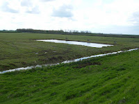
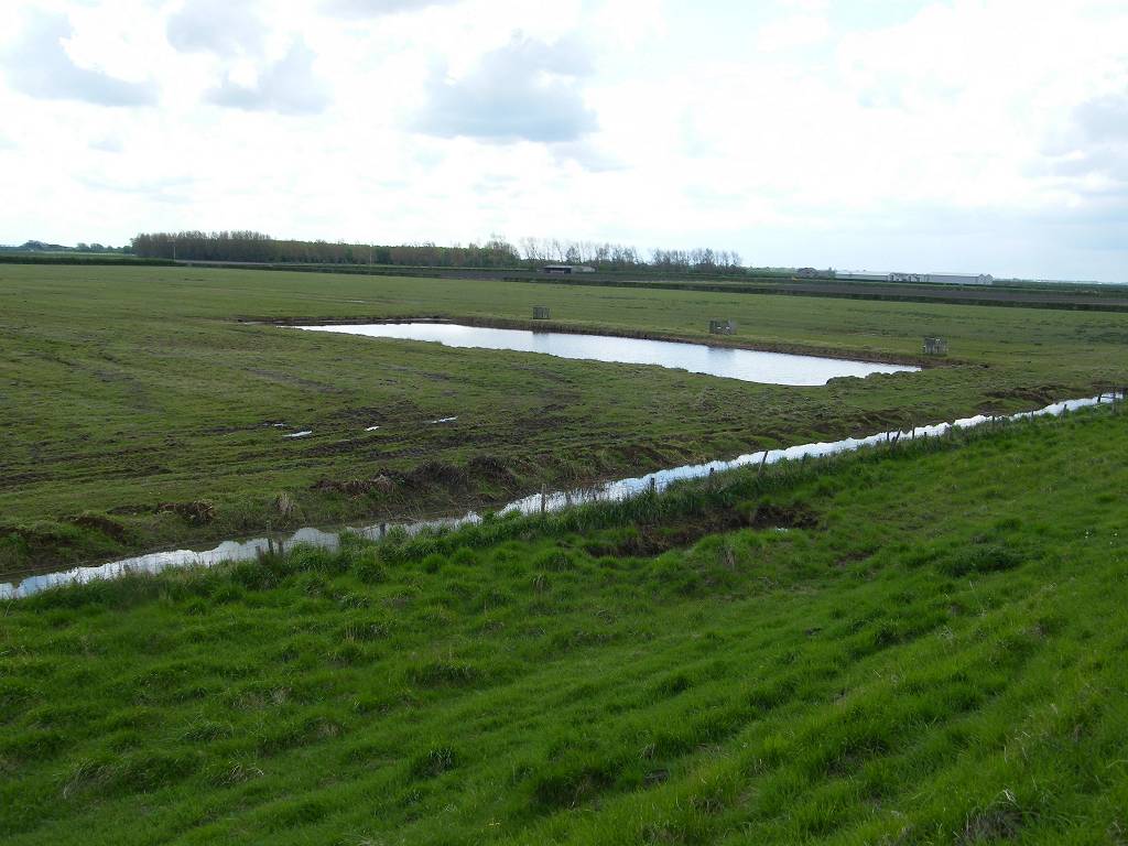
 We came to a car park with an old buoy at the
entrance. Up on the bank ahead was a
RSBP shelter with benches in it — this proved to be a lovely comfortable place
to sit and eat our sarnies. It was
overlooking the marshes where there were several pools. We saw a few ducks, but not many other kinds
of birds.
We came to a car park with an old buoy at the
entrance. Up on the bank ahead was a
RSBP shelter with benches in it — this proved to be a lovely comfortable place
to sit and eat our sarnies. It was
overlooking the marshes where there were several pools. We saw a few ducks, but not many other kinds
of birds.
 We continued, and got to the end of the long
straight path where the public footpath turned inland to the road. It looked as if we could continue straight on
and link up with another sea bank a quarter of a mile away, but nothing was
marked on the map. We decided to be
‘good’ and divert inland, I was in no mood for Right-of-Way confrontations,
ditches or barbed wire. (It was a bum decision, and we wished later we’d
just gone for it.) It was a mile to the
road and another mile out again on a parallel track a mere hundred yards away.
We continued, and got to the end of the long
straight path where the public footpath turned inland to the road. It looked as if we could continue straight on
and link up with another sea bank a quarter of a mile away, but nothing was
marked on the map. We decided to be
‘good’ and divert inland, I was in no mood for Right-of-Way confrontations,
ditches or barbed wire. (It was a bum decision, and we wished later we’d
just gone for it.) It was a mile to the
road and another mile out again on a parallel track a mere hundred yards away.

 We accessed the road through an avenue of poplar
trees, which have always been my favourite tree — I just love the shape. We also passed a field that was entirely
covered in polythene — what is the countryside coming to? The road was busy and the traffic fast, even
though it is a back road. It had no
pavements, we just had to dodge.
Fortunately it wasn’t far. The
private road back to Marsh Farm was busier than we had anticipated, with
agricultural vehicles bearing down on us and cars kicking up a dust. We would have been much more out of the way
scooting along the sea bank — how we wished we’d done that! There was mass planting in progress on the
neat fields — this is not the countryside, it’s a factory!
We accessed the road through an avenue of poplar
trees, which have always been my favourite tree — I just love the shape. We also passed a field that was entirely
covered in polythene — what is the countryside coming to? The road was busy and the traffic fast, even
though it is a back road. It had no
pavements, we just had to dodge.
Fortunately it wasn’t far. The
private road back to Marsh Farm was busier than we had anticipated, with
agricultural vehicles bearing down on us and cars kicking up a dust. We would have been much more out of the way
scooting along the sea bank — how we wished we’d done that! There was mass planting in progress on the
neat fields — this is not the countryside, it’s a factory!
 We passed Marsh Farm and went across a field to a
stile. There we put on our full
wet-weather gear because it had started to rain, but it didn’t really come to
much. Over the stile we had to scramble
straight up the steep seabank, there was no path. At the top we realised that if we’d been
walking the coast the other way we’d never have seen that stile and would have
continued walking until we met the other seabank. That is when we really wished we’d done just
that and missed out the road bit.
Hindsight is a wonderful thing!
We passed Marsh Farm and went across a field to a
stile. There we put on our full
wet-weather gear because it had started to rain, but it didn’t really come to
much. Over the stile we had to scramble
straight up the steep seabank, there was no path. At the top we realised that if we’d been
walking the coast the other way we’d never have seen that stile and would have
continued walking until we met the other seabank. That is when we really wished we’d done just
that and missed out the road bit.
Hindsight is a wonderful thing!
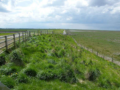
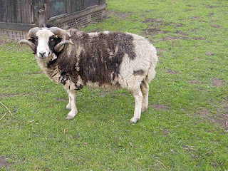 The top of the bank was very muddy because cattle
had been up there and churned it up. We
passed some sheep with curly horns. We
also passed a dead cow lying on the edge of the marsh. While we were wondering who we should inform, the farmer came along with his tractor to scoop it up. So he already knew about it — I wonder why it
died.
The top of the bank was very muddy because cattle
had been up there and churned it up. We
passed some sheep with curly horns. We
also passed a dead cow lying on the edge of the marsh. While we were wondering who we should inform, the farmer came along with his tractor to scoop it up. So he already knew about it — I wonder why it
died.
It was muddy all the way to Old Hollow Farm, and beyond. It was difficult walking so we went down on to the edge of the marsh, but it wasn’t much better there. After a while I climbed back up again because it was too uneven. It was still muddy on top, but less so than further back. We came to a stile, and it was grassy and smooth the other side — at last! We sat on the stile to eat our apples. We removed our wet-weather gear as the sun was once again shining.
It was much easier walking from thereon, and we could see the road. We met a woman with a dog, she was only the third person we had met since starting this morning. We crossed the creek at Fiddler’s Ferry — now we were in Merseyside, no longer in Lancashire.
 We passed a huge granite rock on display. Granite?
In this flat fen-like area? A
notice told us that it was dug out of the ground in 1959 when they were building
a pumping station. It is Criffel Granite
— but Criffel was miles back in Dumfries & Galloway! They concluded that it was brought here by
ice, 18000 years ago. It is an
‘erratic’. It just shows the power of
the ice, and how huge the glaciers must have been. Mind boggling!
We passed a huge granite rock on display. Granite?
In this flat fen-like area? A
notice told us that it was dug out of the ground in 1959 when they were building
a pumping station. It is Criffel Granite
— but Criffel was miles back in Dumfries & Galloway! They concluded that it was brought here by
ice, 18000 years ago. It is an
‘erratic’. It just shows the power of
the ice, and how huge the glaciers must have been. Mind boggling!

 There was a cycleway alongside the creek behind the
houses, so we didn’t have to walk along the road as our map indicated. There was apple-blossom in the hedge to our
left, and wading birds in the creek to our right. Walking was very easy, and we felt a lot more
relaxed as we approached Southport. At the mouth of the creek the cycleway
continued beside a road until we reached a car park. Between us and the houses was a wide marshy
area with ponds. We sat on a bank to eat
our chocolate. We could see Southport
Pier ahead, and if we looked through our telescope/binoculars we could see Blackpool Tower behind.
There was a cycleway alongside the creek behind the
houses, so we didn’t have to walk along the road as our map indicated. There was apple-blossom in the hedge to our
left, and wading birds in the creek to our right. Walking was very easy, and we felt a lot more
relaxed as we approached Southport. At the mouth of the creek the cycleway
continued beside a road until we reached a car park. Between us and the houses was a wide marshy
area with ponds. We sat on a bank to eat
our chocolate. We could see Southport
Pier ahead, and if we looked through our telescope/binoculars we could see Blackpool Tower behind.

 The path continued along the top of the marsh — it
reminded us of Grange-over-Sands where there is marsh-grass instead of sand and
sea. The sun was now bright in a
cloudless sky. A bit too bright as it
happened, because it was setting in a low sky at that time of day making
photography difficult. It got squidgy
underfoot so we went up on the prom. Then
the marsh gave way to firm sand, so we went back down again. In places there were patches of crushed
shells on the beach.
The path continued along the top of the marsh — it
reminded us of Grange-over-Sands where there is marsh-grass instead of sand and
sea. The sun was now bright in a
cloudless sky. A bit too bright as it
happened, because it was setting in a low sky at that time of day making
photography difficult. It got squidgy
underfoot so we went up on the prom. Then
the marsh gave way to firm sand, so we went back down again. In places there were patches of crushed
shells on the beach.

 We reached the pier and could see men doing
press-ups on the beach just beyond it. We
climbed up some steps on to the pier, but the sea end was closed with a stark
warning notice — we were too late in the day.
We reached the pier and could see men doing
press-ups on the beach just beyond it. We
climbed up some steps on to the pier, but the sea end was closed with a stark
warning notice — we were too late in the day.
 We were actually halfway along the pier on the seafront where we were
standing. The construction starts on the
edge of town across the marsh, which here has been converted into marine
lakes.
We were actually halfway along the pier on the seafront where we were
standing. The construction starts on the
edge of town across the marsh, which here has been converted into marine
lakes.
 Yesterday, on our ‘rest’ day, we
walked the shore half which is open all the time. We thought we’d leave the sea half to today
when we were on our Walk, but they closed it too early.
Yesterday, on our ‘rest’ day, we
walked the shore half which is open all the time. We thought we’d leave the sea half to today
when we were on our Walk, but they closed it too early.
 We continued along the prom. The athletes were doing jump-ups on to the
wall, then they all ran past us on the beach.
We wondered what event they were training for. We passed a fairground on the marshes — free
to enter, unlike Blackpool.
We continued along the prom. The athletes were doing jump-ups on to the
wall, then they all ran past us on the beach.
We wondered what event they were training for. We passed a fairground on the marshes — free
to enter, unlike Blackpool.
 It had a small Ferris wheel, but none of the
rides were open when we passed. Colin
remembered going to that fairground as a child when he was holidaying in Blackpool with his parents, but his memories were of a
much more exciting place than it appeared to be today. (Possibly he was remembering through
rose-tinted spectacles…..?)
It had a small Ferris wheel, but none of the
rides were open when we passed. Colin
remembered going to that fairground as a child when he was holidaying in Blackpool with his parents, but his memories were of a
much more exciting place than it appeared to be today. (Possibly he was remembering through
rose-tinted spectacles…..?)

We passed a post marking the end, or the beginning, of the Trans-Pennine Trail. We came across the other end of this in Hornsea when we were walking the Yorkshire coast back in 2005. It is a cycle trail across the country, but it can be walked as well. Colin pointed out Chesterfield, the town of his birth, marked on the post.

We continued along the lower prom which was just above the sand. Then the marsh grass started again, it seems the bare sand is only for about half a mile either side of the pier. We followed a path along the top of the marsh to the second roundabout where our car was parked in a free car park — probably considered too far out of town to be worth bothering with charges. In the distance we could see the Welsh mountains — nearly there!
 That ended Walk no.324, we shall pick up Walk no.325 at the second
roundabout just south of Southport. It was twenty-five past seven, so the Walk
had taken us eight and a quarter hours. We
drove straight back to the caravan to have our tea in comfort because it wasn’t
far.
That ended Walk no.324, we shall pick up Walk no.325 at the second
roundabout just south of Southport. It was twenty-five past seven, so the Walk
had taken us eight and a quarter hours. We
drove straight back to the caravan to have our tea in comfort because it wasn’t
far.
Location: Hesketh Bank to Southport.
Distance: 15 miles.
Total distance: 3332 miles.
Terrain: Mostly grassy/muddy river banks. Some tarmac/concrete. Some marsh/beach. Flat.
Tide: Coming in, later going out.
Rivers: No.400, Three Pools Waterway.
Ferries: None.
Piers: No.33, Southport — but it was closed because we reached it too late in the day.
Kissing gates: Nos.416, 417, 418, 419, 420 & 421 on the river banks.
Pubs: None.
‘English Heritage’ properties: None.
Ferris wheels: No.10 in Southport, but it was not running.
Diversions: None.
How we got there and back: We were staying in our caravan near Southport. This morning we drove to a beach car park a little to the south of Southport. From there we walked to Lord Street where we caught a bus to Hesketh Bank. We alighted at the church, and walked down the road to the boatyard where we finished the last Walk.
At the end we came to the car on the beach. We drove straight back to the caravan to have our tea in comfort because it wasn’t far.


It was muddy all the way to Old Hollow Farm, and beyond. It was difficult walking so we went down on to the edge of the marsh, but it wasn’t much better there. After a while I climbed back up again because it was too uneven. It was still muddy on top, but less so than further back. We came to a stile, and it was grassy and smooth the other side — at last! We sat on the stile to eat our apples. We removed our wet-weather gear as the sun was once again shining.
It was much easier walking from thereon, and we could see the road. We met a woman with a dog, she was only the third person we had met since starting this morning. We crossed the creek at Fiddler’s Ferry — now we were in Merseyside, no longer in Lancashire.


We passed a post marking the end, or the beginning, of the Trans-Pennine Trail. We came across the other end of this in Hornsea when we were walking the Yorkshire coast back in 2005. It is a cycle trail across the country, but it can be walked as well. Colin pointed out Chesterfield, the town of his birth, marked on the post.
We continued along the lower prom which was just above the sand. Then the marsh grass started again, it seems the bare sand is only for about half a mile either side of the pier. We followed a path along the top of the marsh to the second roundabout where our car was parked in a free car park — probably considered too far out of town to be worth bothering with charges. In the distance we could see the Welsh mountains — nearly there!


No comments:
Post a Comment