Thursday, October 04, 2012

Walk 316 -- Ulverston, via Grange-over-Sands, to Arnside

Ages:  Colin was 70 years and 149 days.  Rosemary was 67 years and 292 days.
Weather:  Foggy, turning sunny and warm.  No wind until later.  Two slight showers.
Location:  Ulverston, via Grange-over-Sands, to Arnside.
Distance:  2½ + 11½ + 2 miles.
Total distance:  3232 miles.
Terrain:  Some roads.  A lot of boggy paths.  One field was a marsh and we got water in our boots.  Promenade for the last couple of miles.
Tide:  In, going out.
Rivers: No.389, Ulverston Channel.  No.390, Mill Race.  No.391, River Winster.  No.392, Kent Channel.
Ferries:  None.  (We pretended a byway across the sands was a ferry at the beginning of the Walk, and that a railway viaduct was one at the end.)
Piers:  None.
Kissing gates:  Nos.394, 395, 396, 397, 398, 399 and 400 at various points along the Walk.
Pubs:  The Pheasant Inn at Allithwaite which we visited the next day because we were in no fit state to enter a pub after paddling through a bog!  Colin drank Cumbrian Legendary ‘Loweswater Gold’ and Coniston ‘Bluebird Bitter’ while I sipped from his glasses because I had taken lots of painkillers for my bad back.
‘English Heritage’ properties:  None.
Ferris wheels:  None.
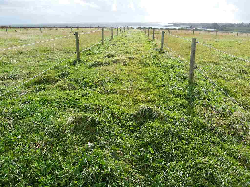
Diversions:  No.67, a very short one where the sea bank had been repaired and reseeded.
How we got there and back:  We were staying in our caravan at Grange-over-Sands.  This morning we walked two and a half miles to Grange-over-Sands station where we caught a train to Cark.  There we walked through this very pretty village to the point where a byway across the sands from Ulverston was supposed to end.
At the end we finished the Walk where the railway went across the sands to Arnside.  We walked a couple of miles up to our caravan site.  We didn’t use the car at all.  Two days later we went home because I was in dreadful pain from my back problem and couldn’t walk.

Our little granddaughter, Natalie, is five years old today — how time flies!  When she was born in 2007, eight weeks early and weighing a tiny 2lbs 12oz, she gave us many worrying moments.  Especially when she caught an infection, and when it was discovered that she also had a cleft palate.  But she was strong, and with the devotion of her loving parents, the unsurpassed care of the staff at Addenbrooke’s Hospital and several procedures and operations on her mouth and ears, she is now a pretty, bright, healthy and happy five-year-old.
She started school a month ago, loves it and is coming on in leaps and bounds with her reading.  She is a very special little girl.

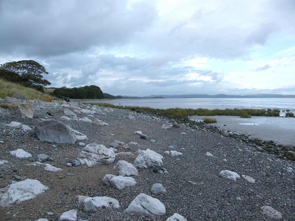
We decided not to walk across the treacherous Cartmel Sands from Ulverston at the start of this Walk in the interests of safety.  Nor did we want to walk miles inland to the first crossing point of the river because this is a coastal trek after all.  So we began today’s Walk in the village of Cark where the BOAT (Byway Open to All Vehicles) from Ulverston comes back on to dry land.  At this end there is still a good track across the marshes, and we wondered if it is used by locals for cockling on Morecambe Sands.
My camera is packing up!  It is a ‘bridge’ digital camera which I bought four and a half years ago.  It takes fantastic pictures both near and far, and I am very fond of it.  I must have taken thousands of shots with it, and not a few videos.  This morning the shutter was very sticky, and I found it almost impossible to work.  I had to put my thumb underneath the camera body while I pressed with my finger from the top, and then it didn’t always take.  This made photography very difficult throughout the Walk, and I didn’t take nearly as many photos as I wanted.
A footbridge across a stream was blocked by a locked gate.  Colin wanted to go that route because it was shorter, but it is not a right of way.  He swung round the end of the gate and said it was “easy”.  I didn’t follow for two reasons:  my balance is none too good these days, and we didn’t know if we could get out the other end.
So we walked into the pretty village of Cark where the stream was running high after all the rain we have had in recent weeks.  We crossed this rivulet on a little stone bridge and followed the track which went under the railway. 
The path then seemed to go alongside the railway though, according to the map, it turned at right angles and followed a wall.  We came out on a byway where there was a Cumbrian Coastal Way signpost — a rare sight — so we knew we were in the correct place.  We sat on a wall to eat our pies.
We followed this byway to a lane which took us down through a farm.  We passed the other end of the ‘illegal’ path, and the track came out through an open gate — so we could have come that way after all.  Oh well…..  The path continued round the edge of the marsh.  It was boggy in places but we always managed to find our way through without getting too muddy.
One time we climbed a hill by a fence next to a field because it looked the way to go, then we saw a stile down below!  I came down straight away but Colin stayed up there until he got to the fence, then he had to come down the steep way to the stile.  We met a man coming towards us who told us we’d need wellingtons to get through further on — he’d obviously got water in his boots.  When we got to the place he mentioned, we edged our way in a wider sweep through the marsh.  It was squidgy but not deep, so we got through unscathed.
The early morning fog cleared, the sun came out and it got hot.  So we peeled off the layers.  Colin faffed in his usual way, and I went on until I came across part of a plastic chair amongst the beach rubbish.  There I sat in relative comfort until he caught me up.
After a boggy bit, the path led us up on to a grass embankment.  This was a vast improvement — it was a lovely even surface, and dry!  We passed a herd of cows who tried to stand it out for a while, then they suddenly jumped and scattered.
There was a short diversion where the bank had been reseeded.  We wondered whether there had been a breach in this grass seabank which had been recently repaired.  At the end we saw what we thought was a wall, but as we approached we found it was actually a man-made rocky sea defence.  We sat on the rocks to eat our sarnies while several groups of dog-walkers passed us.  It was almost too hot in the sun — lovely weather for a change.
We turned into a road which took us along two sides of a disused airfield.  We had considered trying to cut across it as a short cut, but were very glad we didn’t when we saw how impossible it was to get out the other end.
We passed a farm with strange underground shelters under grassy mounds.  We wondered what they were, and put forward two theories — growing mushrooms?  An ‘earth-house’ built mainly underground?  We were probably wrong on both counts!
It started to rain partway along the road.  Colin took ages faffing about donning his wet-weather gear……and then it stopped!  I was watching a triple rainbow and he got very tetchy about photographing it — which we didn’t because my camera is on the blink and he wouldn’t get his out.  He was very tired, and so was I.  On the one bend in the road we met the only bit of traffic — a huge articulated lorry came belting round at great speed, filling the lane and we had to leap into the hedge to save our lives!
We passed a number of flooded fields on the way.  We turned down a lane towards Humphrey Head and found it was flooded from edge to edge.  Colin immediately got up on the grass verge expecting me to meekly follow.  But I had a theory that the flood wouldn’t be quite so deep in the middle of the road because of the camber.  I put my theory into practice, and found that I was right.  At the edges the floodwater would have soaked into my boots, but in the middle it was shallow enough to stay below the tops.  Colin admitted he was amazed — quite something for him!  He had to turn back because even on his grass verge the water got too deep.  He then followed me along the middle of the road, and when he caught up with me he gave me a kiss — things were looking up!
Further on we came to where the Cumbrian Coastal Way cut across Humphrey Head (it was even signposted), a path we intended to take because all the paths to the end of this rocky peninsula are dead ends.  But — a huge deep puddle barred our way.  This time there was no way a path through the middle, or even round the edges, would keep the water out of our boots.
There seemed to be no way round it, so we continued down the lane.  We turned into an entrance on our left, then immediately turned left again down into a muddy wood where we had to skirt a pond.  Colin found me a stick to help with my balance because it was extremely muddy and slippery underfoot.  We came to a wall separating us from the track we needed to be on, but it had rather a lot of barbed wire along the top.  So we bashed our way past nettles and brambles to where the barbed wire was missing, and climbed over the wall — me with great difficulty because my sensitive back was stiffening up.  Colin had to partially rebuild the wall after I had scrambled over!
The track led us up a hill between two hedges, then down to the marsh with lovely views across Morecambe Bay.  The next bit of the path, alongside the marshes, is not marked as a right of way on the map but it is signposted as the Cumbrian Coastal Way in the field.  It was the last such signpost we saw on today’s Walk despite the fact that we were following the Way all day.  We got to a farm, and considered trying to get along the edge of the marsh for about a quarter of a mile to Kents Bank Station — it would have considerably shortened our Walk.  But we couldn’t even get the few yards to the corner, the ground was soft and sank in too deep for our boots.  (Later we were to regret this decision, did we try hard enough?)
So we took the legal way by climbing over some ‘granny’s teeth’ on to a track which took us under the railway.  It was a very low bridge with awkward gates, and we were glad a train didn’t go over when we were underneath — too close to our heads! 
The first two fields were OK to walk through, the third was a swamp!  There was no sign of a path through, it was supposed to go straight on according to the map.  Our feet sank deeper and deeper as we tried jumping from clump to clump of marram-type grass.  Colin decided to go off in completely the wrong direction as it “looks drier over there”.  I carried on, it was a nightmare!  I was half-standing on one of the clumps — couldn’t get all of both boots on — when my feet slowly slipped sideways.  There was nothing I could do about it, nothing to hold on to and nowhere to go, as I sank to my ankles, boots full of water.  After that I didn’t care — I sloshed on, my boots coming out with great sucking noises.  I just hoped they would come out every time, but sometimes they needed a lot of strength.  I was hating this and quite upset.
At the far end of the field I made over to a slightly drier part as I couldn’t see a gate or stile to get us out of this swamp.  I turned round to see how far Colin had got and I couldn’t see him anywhere!  I thought I had a view the whole field from where I was standing, and there was no sign of him.  I panicked!  I called out several times, cupping my hands and listening for an answer.  There was none.  What was I to do?  I didn’t know how to get out of this swamp, and I seemed to be all on my own.  Where was Colin?  Had something dreadful happened to him?
Then he appeared round the corner of a hedge quite near me!  “Didn’t you hear me call?”  “Yes, of course I did!”  “Then why didn’t you answer?”  “Because all this calling out is silly, and you never hear me when I answer from the garden at home!”  What has that got to do with our present situation?  I was very upset, and tried to explain how I had panicked, but all he would do was berate me about a load of totally unrelated things — he was in a foul mood and his reasoning was erratic.  He was completely impervious to my feelings, and dismissed my upset as “being silly”.  He was being totally unreasonable, and I couldn’t cope with it.
As we were having this almighty row, I noticed another couple paddling their way across the far side of the field where the footpath was supposed to be.  Colin had been yelling, “You’ve got the map, where’s the gate to get out of this field?”  I said, “Watch them!”  As they disappeared into the far corner, the realisation hit him that we would have to walk back over the bog.  So far he had managed to escape getting water in his boots — not any more!
At the gate was a pond, a deep pond, and there was no getting round it.  Water was halfway to my knees as I paddled over there and leapt up on to the gate.  On the other side of the gate was a simple wooden plank bridge over a ditch, but this ditch was so full the plank was actually under water and it was difficult to see it’s exact location.  I tried to work my way round without treading on the ground, and failed.  Then I had to negotiate another pond which was even deeper than the first.  I squidged out into the muddy field and waited for Colin.  He was ages trying to find another way round, but there wasn’t one.  Both of us ended up with boots full of water.  The stile leading out of this next field was also in a pond, but we saw a gate further up which wasn’t so we used that.  At last we were on a half-decent track.
We soon came to a woodpile and I sat down and removed my boots, tipping the water out.  I didn’t remove my socks because I thought I would never get them on again.  When I put my boots back on my feet were still sloshing in pools of water.  And so we continued for the next five miles — Slish! Slosh!  Slish! Slosh! Slish! Slosh!.......  Colin refused to take his boots off, but he had calmed down to his usual complaining level and was no longer being so totally unreasonable.  We ate our apples, didn’t feed the horses as requested and moved on.
We came to the village of Allithwaite where there was a ‘real ale’ pub which Colin was anxious to visit.  But in our muddy state with squelching boots there was no way we could enter such an establishment, so we passed it by.  We visited it the next day and had a pub lunch there.  The food and drink were fine, but the waitress was overbearing and we were overcharged.
About a mile up the road was Cartmel Priory which we also visited the next day.
Cartmel Priory

Cartmel Priory was founded in 1190 by the first Earl of Pembroke.  It was occupied by the Augustinian Canons and dedicated to St Mary the Virgin and St Michael.


Like most of these 12th century priories it was added to and embellished in the 13th, 14th and 15th centuries until it was dissolved in 1536.  Difficult and dangerous times — because four of the monks were hanged along with ten of the villagers who had supported them.
However the church was not destroyed because it was the only place of worship for the village of Cartmel, and despite the lead being stripped from the roof, despite it being used as a stable, a prison and a grammar school in subsequent centuries, it is still used as their parish church today.

We were most interested in the twenty-five misericords which date from 1440 and depict life in rural England 15th century style.  They also feature the Green Man, a pagan symbol of fertility.
Back to the Walk:
We turned on to a narrow lane to bypass the village, but it wasn’t evident from the map that it was such a steep hill.  The first car coming down towards us, driven by a young man (of course) was going so fast on that steep and narrow road that I yelled after him, “Slow down!”  We seemed to be going up for ages, then we had to walk all the way down again to Kents Bank Station.  There are rights of way across the sands of Morecambe Bay, but like the Broomway off Foulness Island in Essex, they are far too dangerous to be followed by anybody without an intimate knowledge of the local tides, channels and quicksands.  There were notices all along warning us about dangerous footpaths and advising us to seek local advice.
Kents Bank is where the official walks across Morecambe Bay usually end.  Cedric Robinson, the Queen’s official guide, has been leading groups of people — usually charity fund-raisers these days — from Arnside to Kents Bank for more than fifty years.  Now in his eighties, he has no intention of giving up and leads approximately thirty walks a year across the treacherous sands.  The route can vary from day to day, depending on the shifting sands, and can only take place at low tide, of course.  The walk is between seven and eight miles long, starts on the stony foreshore at Arnside, proceeds across the channels of the River Kent which can be up to thigh-deep, and ends by crossing wide and slippery gullies on the saltmarsh.  We had tinkered with the idea of doing it as part of our Round-Britain-Trek, but decided against it in the end.  I don’t think we would have enjoyed being exposed on the sands for several hours on what must be extremely difficult terrain.  Besides, the walk is always from Arnside to Kents Bank, the wrong way for us!
We didn’t cross the railway.  The road we were on ran parallel to the track until we turned on to a concrete footpath which also ran parallel.  Further on we passed a large area which was being dug up to lay new sewers — fortunately the footpath had been left open.
After that the path led under the railway, and immediately we were on the promenade.  But no ordinary seaside promenade this.  Grange-over-Sands should be renamed Grange-over-Marsh for it is a long time since the sea came anywhere near this prom.  Instead of a sandy beach, green marsh-grass stretches as far as the eye can see.  No sea-bathing at this resort.
We passed a children’s playground.  I didn’t know what the first piece of apparatus was, and as I approached it a disembodied voice said, “Hey!  You!  Yes, you over there!  Do you want to play?”  I was quite startled, looked around and then realised the apparatus was talking to me!  It told me to press a button, which I did but nothing happened.  It didn’t work!  (Perhaps I’m too old.)  We were pleased to see a BMX bike course being well used — by lots of kids on scooters.  How fashions change!
We passed a derelict lido — a sad sight, particularly here where it is impossible to swim in the sea.  We sat on a seat to eat our chocolate near an empty paddling pool and a rather nice sculpture of a bird.  Our feet were still wet and squelching.
We continued past the restored railway station, painted up in all its Victorian glory.  (Very nice, but not nearly so ornate as our restored Victorian station at home in Great Malvern.)  The railway was opened in 1857, an event which revolutionised the Cumbrian coast.  Coke could now be transported from the Durham coalfields to support the heavy industries of Ulverston, Askham, Millom and Barrow.  The effect on Grange was to turn a scattering of fishermen’s cottages lining a tidal inlet into a genteel seaside resort with nice hotels, a promenade, bathing machines on the beach and even a small wooden pier so steamers could bring day-trippers over from Morecambe and Fleetwood.  It all looked a bit decayed today with marsh instead of beach, though we found the town centre to be lively enough when we shopped there.  We caught a train from this delightful station this morning when we set up this Walk.
We crossed the railway at the end of the prom using a footbridge.  We walked along the road, then turned into a lane which led us past a golf course.  The lane was partially under water with wonderful reflections of the trees in the puddles.  When we arrived in the area three days ago this lane was completely flooded, but today it was passable.
We passed the track to Holme Island which we investigated a few days ago.  It crosses the railway and follows a short causeway out to a rock on which stands a big house surrounded by trees.  (It is private, so we didn’t get any further than the gate on which was the name Mr Richard Scholes.)  The island was once owned by the Brogden family — John Brogden was responsible for building the railway and used to live on Holme Island.
We reached the bridge over the River Winster — the water was still high but a little lower than it was the other day.  We could see the problem, why the lane flooded three days ago.  The river in spate failed to flow under the railway because the arches are too low.  The water built up causing the ditch to overflow and flood the lane.
And there we had to leave the shore and the railway, we had no choice because there was a big cliff in the way.  The railway makes its way across the Kent Channel to Arnside on a viaduct which is nearly two miles long.  It would have been about a ten mile detour inland to cross the river at the first road bridge, so we put into practice additional rule no.20, and pretended our two mile walk from that point to our caravan site at Meathop was the two miles we would have walked to Arnside had we been able to.

That ended Walk no.316, we shall pick up Walk no.317 in Arnside, at the other end of the railway viaduct.   It was ten to six, so the Walk had taken us seven hours and fifty minutes. 
The next morning I could hardly move due to back pain.  I reckoned that a week sleeping on a bad mattress in the Peak District coupled with all the jerky movements I made crossing that swampy field, seriously put my back out.  There was no way I could walk any further, so we decided to pack up and come home.  Our goal had been to get to Blackpool in time for the illuminations — that is why we had come up in October — but that was out of the question now.  I was somewhat disappointed, and I felt quite miserable.  (Perhaps I should say “I’m gu’’ed!”, that’s the modern phrase!)  After visiting the pub in Allithwaite and Cartmel Priory the next day, the following day we towed our caravan home and put it away for the winter.
We’ll be back in the Spring!

Tuesday, October 02, 2012

Walk 315 -- Walney Island to Ulverston

Ages:  Colin was 70 years and 147 days.  Rosemary was 67 years and 290 days.
Weather:  Torrential showers interspersed with fleeting sunny intervals.  Fine this afternoon, it even got too hot for a while.  Later rain started, gently at first but it had become torrential by the time we finished the Walk.  We were very wet!
Location:  Walney Island to Ulverston.
Distance:  16 miles.
Total distance:  3216 miles.
Terrain:  A lot of concrete.  Some road-walking.  Beach, both soggy sand and shingle with rocks.  Some extremely muddy fields.  Mostly flat.
Tide:  In, going out.
Rivers: No.388, Devonshire Dock, Barrow-in-Furness.
Ferries:  None.
Piers:  None.
Kissing gates:  No.393 towards the end of the Walk.  It cheered us up when we were feeling like drowned rats!
Pubs:  None.
‘English Heritage’ properties:  No.47, Furness Abbey which we visited on a different day and found it was closed!  No.48, Bow Bridge which we missed because it was behind a hedge!  No.49, Piel Castle which we visited last month when the weather was better.
Ferris wheels:  None.
Diversions:  None.
How we got there and back:  Yesterday we towed our caravan from home to Grange-over-Sands.  This morning we drove to Ulverston and parked at Canal Foot.  We had to walk nearly two miles into town in order to catch a bus to Barrow-in-Furness.  We alighted near the Town Hall and walked to the bridge where we finished the last Walk.
At the end we came to the car in the pouring rain and fading light.  We drove straight back to the caravan, it was too wet to do anything else.

Furness  Abbey  and  Bow  Bridge 
We visited Furness Abbey the next day because it is over a mile inland and we didn’t actually pass it on the Walk.  What we didn’t realise was that, as from 1st October, it was only open at weekends — so  when we got there it was closed!  It is a magnificent Cistercian Abbey built in the 12th & 13th centuries using red sandstone.
It is vast, and in its time it was second only to Fountains Abbey in Yorkshire.  It looked remarkably well preserved, what we could see of it from the road, and it was a great pity that we couldn’t get inside.
We drove off to find Bow Bridge, a packhorse bridge nearby which is also owned by English Heritage.  But we missed it because it was behind a hedge.  Then we realised we were supposed to walk from the Furness Abbey car park along the river bank for about a mile in order to get to it.  We couldn’t be bothered by then as we had driven well past it and we had other things to do.
We didn’t do very well with our ‘cultural interludes’ today! 

This morning we set the alarm for six, and as if on a signal the rain thundered on the roof of the caravan so hard it completely drowned out the radio!  That set the scene for most of the day — pelting showers interspersed with sunshine.  It was ‘elevenses’ time before we got to the bridge ready to start today’s Walk.  So we sat in the adjacent gardens out of the wind and ate our pies.  We had so much rain while we were walking we didn’t take nearly as many photos as we would have liked.
We missed out the dock area because it was industrial.  We followed a road which took us round to cross over the dock on a high-level bridge.  We came to a Morrison’s store where we took the steps down to the car park so we could pop in and use their toilet!
We then walked alongside a busy road for half a mile, but there was a pavement so it wasn’t too bad.
We went under a railway bridge and immediately turned right on to a quieter road lined by terraced houses.  At the end of that we turned on to a potholed road which led back under the railway.  The footpath was at a higher level going under the bridge, but despite the rain the lowest bit of the track wasn’t flooded.
We emerged out in the open the other side of the dock area, and it was very blowy.  We realised we were not on the path marked on the map, but the other side of a rectangle.
We seemed to be going towards the locked gates of an industrial complex, then the path slanted away towards the left.  This was completely the wrong direction, we needed to go right.  A man was coming towards us walking his dog, so we asked him the way — he told us there was a path alongside the fence of the industrial complex going right towards Piel Island.  And so it was, hidden behind the bushes so we couldn’t see it until we were right up to it.
It was a long straight path on unforgiving concrete, we strongly suspected that it was the track of an old railway.  Colin said it was boring.  We passed a gas flare, and we had views across to Barrow and Walney Island.  Part way along, Piel Island came into view.  We came out at the end of the road to Roa Island, but we didn’t go down it because it is dead end.  From the further end of Roa Island runs the short ferry to Piel Island. 
Piel  Island 
We visited Piel Island back in September when the weather was kinder.  We had to drive out to Roa Island on a causeway, then catch a ferry which took us half a mile across to Piel Island.  On this rock there is a pub and a ruined castle — not enough room for much else.  Yet it has a KING!  (Currently the pub landlord).  And a THRONE for him to sit on!  This throne is an old wooden chair in the bar of the pub which has the following notice by it: 
“Be  it  known  that  who  so  ever  not  being  of  the  order,  sits  on  this  fine  ancient  chair  of  Piel,  shall  by  tradition  furnish  refreshments  for  all  those  present.” 
So we didn’t — sit on it, that is.  There were crowds of people there, and it would have cost us several hundred pounds to ‘refresh’ them all!  It is a tradition which dates back to the 15th century when one Lambert Simnel attempted unsuccessfully to usurp the throne of England.  The present ‘King of Piel’ (Steve Chattaway, the pub landlord) was ‘crowned’ in 2007 by sitting in the chair wearing a helmet and holding a sword while alcohol was poured over him.  The ‘King’ is expected to be “a free drinker and smoker and lover of the female sex”.  Quite a coronation! 
We refreshed ourselves at the bar, then we went out to explore the castle.  It was built originally as a fort, and was involved in the smuggling trade for several hundred years.  It is not very big, more like a tower really.  There wasn’t much else to do on this tiny island, so we took the ferry back to Roa Island where we were reunited with our car. 
Back to the Walk.  We decided against visiting the pub we were just passing — this was Colin, should I be worried? — and found a seat further along where we sat and ate our sarnies.  There were nice views, but it was very cold and blowy there.  I was still wearing my cape for warmth, and the wind caught in the hood inflating me like a balloon!
It began to rain before we’d finished our lunch.  As we got up to leave, I stood on the pavement behind the hedge.  There was no wind there and it was much warmer, but there was also nothing to sit on so we could only stand.  We were cold, wet and miserable.  We thought about visiting another pub along the road, but it was a posh hotel so we didn’t.  We felt like drowned rats.
We walked away from Piel and Roa Islands, and passed a strange tall slim tower on the beach.  The infamous mudflats of Morecambe Bay stretched away to our right.  At the next road junction we came across a broken Cumbrian Coastal Way signpost.  It was the only one we saw all day even though we were (supposedly) following this waymarked footpath for the entire Walk.  And then the rain stopped and the sun came out — it was unbelievably pleasant.  What a difference in a few moments!
We thought the next few miles would be a traffic-dodging nightmare, but it wasn’t like that at all.  There was a track between the road and the sea wall at first, then a crude concrete prom.  We were unable to walk along this prom because the tide was right in, the sea choppy and waves were breaking over it.  But we could walk up higher along a pavement, and the road wasn’t very busy.  It was quite bracing — this was the most enjoyable part of today’s Walk.
At the far end of the prom we came to a bus shelter where we could sit out of the wind.  So we went in there to eat our first chocolate.  Sure enough, a bus came along and slowed down thinking we were passengers.  Only about three buses a day — typical!  We passed warning notices about incoming tides, quicksands and deep gullies — Morecambe Bay is a notoriously dangerous place, not to be taken lightly by those who don’t know it.
After about two miles the road turned inland.  We took a track which went straight on, and said “Hello!” to a couple coming out of a caravan park.  They went on to the beach, vast areas of muddy sand which were being revealed as the tide receded.  Our track turned into a footpath, then through a gate and down some steps into a field.  The path followed a hedge up a hill to a corner, and then……nothing.  No way on.
We looked at the map.  There was a parallel public footpath marked further across the field, perhaps we were supposed to be on that.  We rounded some soggy weeds and followed the hedge inland.  Suddenly we came across a stile hidden in the hedge — we couldn’t see it until we were right up to it.  I find stiles very difficult these days, I can’t lift my feet high enough and my back is stiff.  Colin said, “You’ve lost your nimbleness!”  Certainly have!
The next field had a path enclosed between two parallel barbed wire fences across the centre of it, yet it was only a scrabby grass field with no livestock in it.  In fact, the grass on the path looked more lush than the grass in the field either side.  We came to another stile — not easy.  Then we couldn’t see where to go, the grass was boggy and uneven with no sign of a path. 
We eventually found a stile right in the bottom corner, but it was impossible to get to it because of the deep pond in front of it!  There were single-strand barbed wire fences everywhere to make it the only possible way out of the field — we got the impression the landowner didn’t like hikers!  We had to crawl under the barbed wire, then scrabble over a wooden fence.  I’m getting too old for this!
We emerged on to a twisty A-road, and the next half mile was a traffic-dodging nightmare — horrid!  We turned off at Aldingham, a hamlet that consisted of little more than a manor house and a church.
We could see the couple we’d met earlier walking on newly uncovered sand which looked liquid but wasn’t.  In view of our experiences, we wished we’d followed them down there.  Aldingham may be tiny, but it has a public toilet which is free.  It is maintained voluntarily by the local community.  Against all my principles I put some coins in their box — after all they did ask very nicely!
We went down to the beach, we’d had enough of the road.  The sand was fairly firm but sticky, and we kept unexpectedly treading on soft places.  So this is the famous Morecambe Bay — it’s vast!
We had passed several “No Cockling” notices because they have been overfished and stocks are now dangerously low.  This is such a pity for the local fishing families who have made a mean living by cockling on a small-scale for generations.  Outsiders have greedily come in and scooped up the lot.  In 2004, twenty-one Chinese illegal immigrants were drowned in Morecambe Bay whilst cockling for one of these big criminal organisations.  They had no idea how dangerous the incoming tide can be — faster than a man can run — when they were taken out on to the sands and left to their fate.  They were being paid a pittance anyway, slaves really.  One of the bodies wasn’t found until 2010!
We didn’t like walking on the sand.  It was more mud really, and sometimes it was actually under water.  It was too slippery to feel safe, so we came up on to the beach proper.  Sometimes this was OK and sometimes it got a bit stony and rocky.  We put up with it because it was better than the road.
We rounded a corner and came across a man with a digger collecting shingle and filling a trailer with it.  He was taking up the whole width of the available beach, and seemed reluctant to stop to let us get past.  So we ‘ran the gauntlet’ and he had to pause momentarily to avoid scooping us up.  He certainly had made a great big hole in the shingle bank.  Further on we suddenly heard a woman behind us shouting hysterically — so loud we thought she would burst a blood vessel.  She was almost screaming……….“Farmer Thwaites……….!”  (we couldn’t quite make out the rest).  The man on the digger was, by now, taking his stolen shingle along a track past her house at the top of the beach.  He shouted something back to her, but she just kept on repeating the phrase and screaming.
A couple walking their dog a little behind us turned round and said, “Oh dear!”  We allowed them to catch us up so we could ask them what the kafuffle was about.  They answered, “That’s our local farmer, he’s a law unto himself.  He shouldn’t be taking the stones off the beach and she’s afraid that the tide will reach her chalet.”  They spoke as if the whole village was afraid of this Farmer Thwaites who, apparently, has influence on the local Council as well as being a big local landowner.  The age of inequality is by no means past, bullies like him are still getting away with it.  How we felt for the lady in the chalet!
We chatted with this couple until we reached a boggy bit of the beach where they turned round and went back.  Further on we sat on a rock under trees to eat apples.  We chose to sit under the trees because it started to rain — gently at first, but it gradually got harder and harder.  This was no simple shower.
We came to a picnic area where people were still walking their dogs despite the rain — the dogs didn’t seem to mind.  We chatted with one woman who had a playful dog which was positively revelling in it.  They all had cars nearby, but we still had a couple of miles to go.
From there on the path was above the beach and led through woods for some of the time.  It was raining very hard and we were fast losing light, especially under the trees.  We walked for over a mile like this with the rain pelting ever harder and harder.  We hadn’t seen anybody for a while, until a dog appeared in front of us from the direction of the beach closely followed by its owner.  Apart from a grunt, he barely acknowledged our presence as we walked along almost together.  Eventually we all turned inland to a car park where he got into the only car with his dog and drove off.  He didn’t offer us a lift though the rain was pelting down by then and he could see we hadn’t got a car.  (We wouldn’t have accepted it because we were determined to finish the Walk, but it would have been nice to have been asked, considering the weather.)
The next bit of the Walk was along a quiet road, which was OK.  Then we had to go through a farmyard past some horses and across several fields.  They were very boggy with standing water in most of them.  We had to zigzag which wasn’t easy in the half-light.  Colin got a bootful of water in one gateway, so I clung to the fence and leapt across.  I remained dry — in my boots, that is.  It was raining so hard by now it hurt!  We could barely see to read the map, but Colin said he could make out where the gate was on the far side of the last field — I couldn’t see it.  Colin strode out towards it and I followed.  Sure enough, we came to a kissing gate which led out on to a lane.  How glad we were to be out of those soggy fields before it got pitch dark!
The lane led past factories and we had street lights, all of which we recognised from when we walked from the car to the bus this morning.  The rain was now torrential, it was unbelievable!  We had to walk through a playing field which had a concrete path, but that was a river, quite deep, so we had to squidge over the grass.  By the time we arrived at the car parked at Canal Foot, it was quite dark.  And we were wet right through, despite our fancy wet-weather gear.

That ended Walk no.315, we shall pick up Walk no.316 in the village of Cark, across the estuary from Ulverston.  A BOAT (Byway Open to All Traffic) leads from the canal end at Ulverston across the treacherous sands of Morecambe Bay to Cark, so we decided to count such BOATs as redundant ferries or railway viaducts and made up a new rule to accommodate this.   It was seven o’clock (it seemed like midnight!) so the Walk had taken us eight hours and ten minutes.  We immediately started to drive back to our caravan.  The journey was a nightmare — standing water across the road in numerous places, and sheeting rain across our headlights bringing visibility down to almost nil.  How Colin kept the car on the road I don’t know, and it was with great relief that we arrived back safely at our caravan. 
The next day we returned to Ulverston to photograph the end of our Walk — we’d kept the cameras firmly wrapped in polythene ever since the beach where the farmer was stealing the shingle.  We also visited Furness Abbey, but couldn’t get in.