Weather: Overcast and breezy. Some rain in the middle of the Walk. Not cold.
Location: Achnamara to Balimore.
Distance: 11 miles.
Total distance: 2520 miles.
Total distance: 2520 miles.
Terrain: Mostly a
minor road, slightly undulating.
Tide: Coming in.
Rivers: No.301, the Lussa.
Ferries: None.
Piers: None.
Kissing
gates: No.217, leading into Castle
Sween.
Pubs: None.
‘Historic Scotland’
properties: No.26, Castle Sween.
Ferris wheels: None.
Diversions: None.
How we got there and back: We were staying in our caravan in Lochgilphead. Since the weather was fine(ish!) we decided to save another taxi fare. So we put Colin’s bike in the back of the car and drove to Achnamara. I got out, and spent an hour and a half sitting on a collapsed table (it was actually fairly comfortable!) outside the village hall doing my puzzle books. Meanwhile Colin drove to Balimore where he parked the car and cycled back. He chained his bike to a post.
At the end, we finished our Walk at the car. We had our tea and caramel shortcake, then drove back to Lochgilphead, picking up the bike as we passed through Achnamara.
The next day we drove home to Malvern.

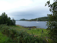 We walked south out of Achnamara on the lane which led mostly alongside
Loch Sween. We had lovely views across
the loch where a few yachts were moored.
We saw lots of herons during the course of the day — so many we have
become quite blasé about them, didn’t even bother to photograph them for the
most part. It was a dull and overcast
day, the light much too ‘flat’ for good photography, but it is amazing how
water can pick up and reflect tiny variations in its ripples.
We walked south out of Achnamara on the lane which led mostly alongside
Loch Sween. We had lovely views across
the loch where a few yachts were moored.
We saw lots of herons during the course of the day — so many we have
become quite blasé about them, didn’t even bother to photograph them for the
most part. It was a dull and overcast
day, the light much too ‘flat’ for good photography, but it is amazing how
water can pick up and reflect tiny variations in its ripples.

 We could see the village
of Tayvallich across the
loch — we didn’t have to walk round the peninsula on which it lies because that
would have been a dead end. We sat on
the wall of a river bridge to eat our pies.
We could see the village
of Tayvallich across the
loch — we didn’t have to walk round the peninsula on which it lies because that
would have been a dead end. We sat on
the wall of a river bridge to eat our pies.

After passing a very ornamental gate leading into the ‘Eilean Loain Estate’ we came to a garden full of ornaments — gnomes, little round houses, animals, that kind of thing. It was a bit over-kill.
 Next we passed some
riding stables with an ornamental gate depicting what they were. (I suppose, when you saw it, you knew you had
arrived at the right place.)
Next we passed some
riding stables with an ornamental gate depicting what they were. (I suppose, when you saw it, you knew you had
arrived at the right place.)
It began to rain so we donned our capes, etc. Then we sat under a tree to eat our sarnies — it wasn’t wet under there. Further on the rain stopped and we got hot in our wet clobber. So we removed it. Wait for it to rain again…………. it didn’t!
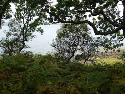 The lane had wandered inland a bit, but then we came to a wooden signpost
telling us of a “shoreline walk 500m”.
So we followed a track which did, indeed, lead us down through trees to
the shoreline.
The lane had wandered inland a bit, but then we came to a wooden signpost
telling us of a “shoreline walk 500m”.
So we followed a track which did, indeed, lead us down through trees to
the shoreline.
 There we saw a rocky
island on which a number of birds were resting.
The track continued for a while parallel to the shore before spitting us
out on the beach. The shingle was a bit
loose, but walkable.
There we saw a rocky
island on which a number of birds were resting.
The track continued for a while parallel to the shore before spitting us
out on the beach. The shingle was a bit
loose, but walkable.
 We rounded a corner, after which the beach disappeared. But a path led up on to some grass and
continued onwards. Soon we came to a
stream, and my heart sank — for it was far too deep and wide to cross! I thought we would have to backtrack all the
way to the road, which by now was about half a mile back — a whole mile of
wasted energy! But Colin looked around for
another solution.
We rounded a corner, after which the beach disappeared. But a path led up on to some grass and
continued onwards. Soon we came to a
stream, and my heart sank — for it was far too deep and wide to cross! I thought we would have to backtrack all the
way to the road, which by now was about half a mile back — a whole mile of
wasted energy! But Colin looked around for
another solution.
 He noticed that the stream was much narrower a little inshore in the
adjacent field. So we climbed over the
fence, which wasn’t barbed wire thank goodness, and found the narrowest part of
the burn. We jumped over, then climbed
back over the fence to the track, which led us back on to the beach. (I didn’t think to photograph the stream
until we had done this, and backtracked a little to take my picture.)
He noticed that the stream was much narrower a little inshore in the
adjacent field. So we climbed over the
fence, which wasn’t barbed wire thank goodness, and found the narrowest part of
the burn. We jumped over, then climbed
back over the fence to the track, which led us back on to the beach. (I didn’t think to photograph the stream
until we had done this, and backtracked a little to take my picture.)

 The beach petered out as we came
to some upturned boats and a path leading into a caravan site, which was huge! It was on lots of different levels with hedges
and bushes everywhere, we got quite lost.
We could see the ruined castle, but couldn’t get to it. Eventually a man in one of the caravans told
us the way.
The beach petered out as we came
to some upturned boats and a path leading into a caravan site, which was huge! It was on lots of different levels with hedges
and bushes everywhere, we got quite lost.
We could see the ruined castle, but couldn’t get to it. Eventually a man in one of the caravans told
us the way.

 Castle Sween was built in the 12th century by the
MacSweens. It was added to in subsequent
centuries, and changed hands several times before being abandoned in the 17th
century. We were surprised to find it is
now owned by ‘Historic Scotland’ as it doesn’t feature on the map we have of
their properties. We found it to be more
extensive and more interesting than we first thought, and there was a lovely
view along the loch from the doorway. It
is free to enter as well — probably too remote to make it at all worthwhile to
have someone on site charging for entry.
We enjoyed our visit, it was worth the climb up to it.
Castle Sween was built in the 12th century by the
MacSweens. It was added to in subsequent
centuries, and changed hands several times before being abandoned in the 17th
century. We were surprised to find it is
now owned by ‘Historic Scotland’ as it doesn’t feature on the map we have of
their properties. We found it to be more
extensive and more interesting than we first thought, and there was a lovely
view along the loch from the doorway. It
is free to enter as well — probably too remote to make it at all worthwhile to
have someone on site charging for entry.
We enjoyed our visit, it was worth the climb up to it.


We used the caravan site road to get back on to the tarmacked lane which we followed for the rest of the Walk. Looking back, the castle seemed very imposing up on its rocky knoll.

 The road led on and on, not quite on the
shoreline by now, but we were up high and were treated to gorgeous views as we
neared the end of the loch.
The road led on and on, not quite on the
shoreline by now, but we were up high and were treated to gorgeous views as we
neared the end of the loch.
 We could see
numerous rocky islets peeping out of the water — it must be a hazardous area
for shipping! We sat on a rock by the
roadside to eat our chocolate. Colin
found a dead sheep nearby, but it didn’t smell.
I hate dead things — I have a phobia about them like some people have about
spiders — so I wouldn’t look at it. I
concentrated on the stunning views instead, and moved us on as quickly as I
could.
We could see
numerous rocky islets peeping out of the water — it must be a hazardous area
for shipping! We sat on a rock by the
roadside to eat our chocolate. Colin
found a dead sheep nearby, but it didn’t smell.
I hate dead things — I have a phobia about them like some people have about
spiders — so I wouldn’t look at it. I
concentrated on the stunning views instead, and moved us on as quickly as I
could.
 After a couple of miles we came to the hamlet of Kilmory. There is a ruined chapel which is of historical
interest (apparently) in the village, but we were too tired to walk down and
look at it. We had reached that stage of
the Walk when all we wanted to do was get to the car! (We didn’t miss much — I looked it up on the
internet, and apparently it is so neglected that everything of interest is hidden
under thick hawthorn bushes!)
After a couple of miles we came to the hamlet of Kilmory. There is a ruined chapel which is of historical
interest (apparently) in the village, but we were too tired to walk down and
look at it. We had reached that stage of
the Walk when all we wanted to do was get to the car! (We didn’t miss much — I looked it up on the
internet, and apparently it is so neglected that everything of interest is hidden
under thick hawthorn bushes!)


We rounded a corner — still a good mile from the end of the peninsula, but there are no tracks — and came to a house called Balimore. That is the end of the public road, and our car was the only one in the big car park before a gate leading into the Ellary Estate.

That ended Walk no.265, we shall pick up Walk no.266 next time at the gate leading into the Ellary Estate by the house called Balimore. It was twenty past four, so the Walk had taken us five hours and fifty minutes. We had our tea and caramel shortcake, then drove back to Lochgilphead, picking up the bike as we passed through Achnamara.
We were very tired, and fed up with the rain. The weather forecast was grim. We had already decided to go home, and rethink the ‘pacing’ of our Walks for next year. (I can still do long Walks — up to 20 miles — but I can no longer manage Walks on consecutive days. I have got to have at least one full day to ‘recover’.) Sure enough, we woke the next morning to torrential rain. So we just got on with the packing up, thanking our lucky stars that we weren’t in a tent as some poor souls were further down the field. Towing the caravan, we drove home in one day — all 423miles of it. Well done, Colin!
How we got there and back: We were staying in our caravan in Lochgilphead. Since the weather was fine(ish!) we decided to save another taxi fare. So we put Colin’s bike in the back of the car and drove to Achnamara. I got out, and spent an hour and a half sitting on a collapsed table (it was actually fairly comfortable!) outside the village hall doing my puzzle books. Meanwhile Colin drove to Balimore where he parked the car and cycled back. He chained his bike to a post.
At the end, we finished our Walk at the car. We had our tea and caramel shortcake, then drove back to Lochgilphead, picking up the bike as we passed through Achnamara.
The next day we drove home to Malvern.


After passing a very ornamental gate leading into the ‘Eilean Loain Estate’ we came to a garden full of ornaments — gnomes, little round houses, animals, that kind of thing. It was a bit over-kill.

It began to rain so we donned our capes, etc. Then we sat under a tree to eat our sarnies — it wasn’t wet under there. Further on the rain stopped and we got hot in our wet clobber. So we removed it. Wait for it to rain again…………. it didn’t!


We used the caravan site road to get back on to the tarmacked lane which we followed for the rest of the Walk. Looking back, the castle seemed very imposing up on its rocky knoll.


We rounded a corner — still a good mile from the end of the peninsula, but there are no tracks — and came to a house called Balimore. That is the end of the public road, and our car was the only one in the big car park before a gate leading into the Ellary Estate.

That ended Walk no.265, we shall pick up Walk no.266 next time at the gate leading into the Ellary Estate by the house called Balimore. It was twenty past four, so the Walk had taken us five hours and fifty minutes. We had our tea and caramel shortcake, then drove back to Lochgilphead, picking up the bike as we passed through Achnamara.
We were very tired, and fed up with the rain. The weather forecast was grim. We had already decided to go home, and rethink the ‘pacing’ of our Walks for next year. (I can still do long Walks — up to 20 miles — but I can no longer manage Walks on consecutive days. I have got to have at least one full day to ‘recover’.) Sure enough, we woke the next morning to torrential rain. So we just got on with the packing up, thanking our lucky stars that we weren’t in a tent as some poor souls were further down the field. Towing the caravan, we drove home in one day — all 423miles of it. Well done, Colin!


