Ages: Colin was 66 years and 329 days. Rosemary was 64 years and 106 days.
Weather: Sunny and quite warm. There was a light breeze, in fact it was PERFECT! (Colin walked in shirtsleeves.)
Location: John O’Groats to Brough.
Distance: 12½ miles.
Total distance: 1869½ miles.
Terrain: Rough cliff top path to start with. But it was mostly quiet roads.
Tide: Coming in.
Rivers: None of significance.
Ferries: None.
Piers: None.
Kissing gates: None.
Pubs: None.
‘Historic Scotland’ properties: None.
Ferris wheels: None.
Diversions: None.
How we got there and back: We were staying in a holiday cottage in Castletown. This morning we got up casually and drove Brough where we had difficulty finding somewhere to park the car off the narrow roads. In the end we backed it on to a piece of rough grass next to a derelict cottage where it couldn’t possibly be in anyone’s way. We caught the bus from the crossroads nearby to John O’Groats car park.
At the end, we came to the car at Brough. Someone had chalked “NO PARKING” on a large stone and put it in front of our car! Would they rather we had parked in the road so that they would have had difficulty getting their farm vehicles past it? No one came to speak to us about it although we were there for about twenty minutes fiddling with our boots and the tea — they just haven’t got the courage of their convictions. Calamity! We had forgotten the caramel squares! Luckily it was only a few miles back to the cottage! We moved the stone aside and drove back.
There were one or two people about at John O’Groats this morning, though we had been the only passengers on the bus from Brough. We got chatting to a lady who lived locally. She told us there was a ‘signpost’ painted on a wall round the corner (we hadn’t seen it) and she offered to take our photos in front of it. With a little help from my computer I have managed to include Bognor Regis on the picture!
What a dump John O’Groats is! It is merely the end of a road, nothing more. Even the fancy-looking hotel there is derelict. I know we were fairly early in the morning, well not
that early, but only the toilets seemed to be open! And they cost 20p per go! I think it is immoral to charge for toilets in public places — of all the things that should be paid for country-wide out of our taxes, it should be free public toilets in every place where a number of people are likely to gather. I feel very strongly about this, especially since we have got older and Colin has developed prostate problems. To charge for such a basic need is discrimination against those with an embarrassing disablement, and causes many people, especially the elderly, to be afraid to go out.We were both quite desperate to ‘go’ after our short journey from the cottage, even though we both ‘went’ before we left — people with strong bladders and bowels will never understand how lucky they are. I couldn’t see anyone about, and so I ‘limboed’ under the barrier. (Actually I crawled!) But when I came out a ‘dragon’ woman was waiting for me with her hand out! She was very haughty, and I know she didn’t believe my muttered excuse that I hadn’t any change, but I don’t care. I don’t suppose I shall ever go to John O’Groats again in my life!
When Colin saw that it was 20p, he went down on the beach behind a rock. Men can do that, it’s not fair! While he was down there he saw a wren hopping about on fishing baskets. A wren is Colin’s favourite bird, and he took some delightful pictures of it. I was struck by the colour of the seawater there, a beautiful turquoise. It looked almost Mediterranean!
And so we started our trek along the very north coast of the British mainland. We had wall-to-wall blue skies and a gentle breeze — it was unbelievable! That put us on a high, and our mood improved as the day wore on. With one or two exceptions, we have found the people who live and work in this remote northern area to be chatty, friendly and helpful. We were looking forward to a good day.
We followed a rough path as far as Huna, about a mile. Actually it wasn’t really a path at all because we had to negotiate drainage ditches, barbed wire fences, etc. We sat on the heather where it was comfortable to eat our pies.
The beach was too rocky to walk, so we tried to get along the top on a grass bank, and succeeded in the end even if the going was slow. So when we got to a derelict farm where the road cut across towards us, we decided that we would have to resort to road-walking or we would never get anywhere today.
Out to sea we could see the island of Stroma quite close by, and beyond that the Orkneys. Further on we read an information board about Stroma. Crofter-fisher families used to live there, their population reaching a high of 375 in the late 19th century. The last family left in 1962, and since then this remote island has been uninhabited. Apparently the tides and currents in these waters are very fast, and therefore dangerous to those who don’t know them. In the days of sail, local fishermen used to act as pilots on passing ships because they knew these seas so well. We reached Huna House which is quite derelict. There is a small harbour there, but it was empty.
Next to it is a kind of runway, the type used to launch old-fashioned lifeboats. This was abandoned as well with weeds growing through it. When we looked inside the shed at the top, which looked like the old-fashioned-type lifeboat shed, we couldn’t believe the collection of old rubbish which met our eyes! Certainly no lifeboat, probably not for a long time since. We picked our way through a motley collection of old vehicles in the farmyard where the local farmer was washing his tractor in the middle of it.
We came out on to the main road. I said brightly, “It won’t be so bad, there’s hardly any traffic!” At that moment, three cars whizzed by us at speed, one passing the other two! However, all the way along that road it was very quiet — nothing like the heavy traffic on that horrible road up to Wick.
There was more shipping traffic on the sea, passing along this north coast of Scotland. I wonder where the lifeboat has to come from these days if any of them get into trouble. We were approaching a church, with a small community hall on the other side of the road. It looked a bit odd, all by itself on this remote coast. It is startlingly white, and was used as a landmark for shipping in previous centuries. It is the most northerly church in mainland Britain. We wondered what community it serves. A notice told us it was an ‘historic’ church, so we decided to have a look. We wandered round the graveyard first, then went inside. It is beautifully kept — absolutely pristine but very plain. We were told it is ‘very old’, but it didn’t look it.
A man inside, it turned out he was the church warden, was fiddling with a projector. He said we were welcome to look around. They are very proud of the fact that the Queen Mother used to worship there whenever she was in residence at the nearby Castle of Mey. There were a number of photos on display, of her entering and leaving the Kirk. We were looking at these when a lady bustled in and said, “I saw you coming along the road. When you’ve finished in here, would you like to come over to the hall and join us with a bowl of soup?” We thanked her, and accepted her invitation.
Well, some bowl of soup! It was home-made, a choice of two flavours and absolutely delicious. This was followed by ham rolls and salad, then a selection of home-made puddings and tea or coffee! There were only four other people round the table besides us — the lady who had prepared all this and invited us in, the church warden, the minister and an elderly lady called Dorothy who had recently moved up from Nottinghamshire to be near her son. The whole ethos of this small gathering reminded us both of our monthly ‘Lunch Club’ which we have at home in our own village hall in Malvern Wells. Lovely people, and they flatly refused to accept payment! “We do this every Thursday!” said the lady-organiser, “you are welcome to come next week if you are still around this area!”
Who says there’s no such thing as a free lunch!
On the way out we passed a piggy bank on a table, so we left a generous donation towards the upkeep of their Kirk. I don’t suppose they have a large congregation to contribute towards it, especially since the Queen Mother passed on. I believe Prince Charles now owns the Castle of Mey, but I don’t think he ever goes there. Such friendly generous people, it put us on a high for the rest of the day — and whenever I have thought about it since my spirits rise. It made a change from munching our sarnies huddled behind a damp rock!
Somehow it didn’t seem to matter any more that we were walking on a road, our spirits were so high with the perfect weather and the friendliness of those lovely people. We watched a ferry leave Gills Bay for the Orkney Islands, but didn’t go down to the ferry terminal as it is a dead end. We recalled our trip across there a few days ago.
I have decided to include our day-trip to Orkney simply because I want to! We have never been there before, so took the opportunity to go across on a day-trip on one of our ‘rest’ days because our cottage is only a few miles from the ferry terminal.
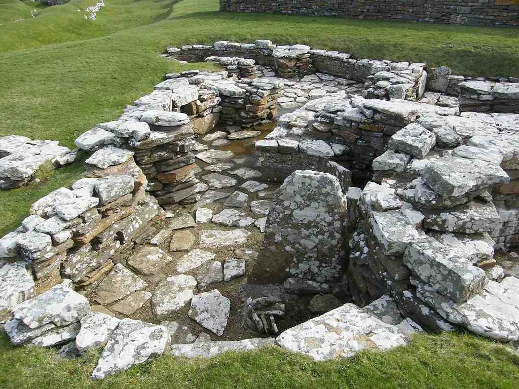
We drove across the Churchill barriers to the Italian Chapel, two Nissan huts which were decorated by Italian prisoners of war. Breathtakingly beautiful! Then we drove on to Kirkwall and had a very quick look round the cathedral. Impressive! Finally we drove to the Broch of Gurness, an iron-age settlement which was only unearthed in 1929 when the leg of an artist’s stool fell down a hole! Fascinating!
By then we had run out of time, so had to come back. We must definitely go again, and stay for longer. Would like to go to Fair Isle and Shetland too.
We continued along the main road as far as East Mey. All the way we had fine views of Stroma and the Orkneys — also back to John O’Groats and ahead to Dunnet Head. The weather was lovely, we felt great! It got quite hot. Colin was walking in his shirtsleeves, and I hung my jumper round my waist. Such a change from last week’s wet, windy, cold and icy storms! We passed a field with some piebald horned sheep in it. An unusual breed, and their lambs were little and gorgeous!
As we approached the tiny hamlet of Gills, there was a hand-painted notice by the side of the road trying to entice us down to Gills Bay. It said simply, “Far better than Groats”!
We thought that really amusing, especially as our own thoughts had been, “Anywhere is better than Groats!” And we’d had the good fortune to be in ‘Groats’ when the weather was unusually calm and sunny. No wonder that fancy hotel closed down! At East Mey we turned right on to a lane so we could walk nearer to the shore. We weren’t sure whether we would be able to get through, but we were prepared to risk it. We had asked Dorothy, the lady at the ‘Lunch Club’ who lives in East Mey, if she thought we would be able to. “Oh no!” she answered, “the farmer keeps bulls in his field at the end of the lane!” Then she admitted she doesn’t walk anymore, but she was adamant that we wouldn’t be able to get past the Castle of Mey on the beach. Why can’t people just admit they don’t know instead of giving out misinformation? That’s the second time in a few days we’ve been told by a local that we can’t get through along the shore, and we subsequently have!
We passed a field with fairly ordinary white sheep in it, but the lambs could only have been a day or two old and were absolutely gorgeous! Pity they have to grow up so fast.
The gorse was in full flower — fantastic!
We didn’t go all the way down to St John’s Point because it is a dead end.
When the lane turned west, we did as well. Now we were walking parallel to the shore but up high so we could still see the views. Dunnet Head loomed ahead, that will be on our next Walk. Colin took a picture of a bird on a post. We came to Long Goe Farm where the bulls were supposed to be. There weren’t any! We continued along a track which took us quickly and easily down to the beach. We sat on the stones to eat our apples.
It was great to be by the lapping waves again, so we walked along the beach out of choice although there was a perfectly good track along the top. All too soon the beach became too rocky, so we had to use the track.
It soon turned into a very usable lane. Celandines were flowering everywhere, and gulls were following a nearby farmer who was ploughing his fields.
We were coming to the Castle of Mey, and passed it with no trouble on its northern side. The castle was built in the 16th century as a residence rather than a defensive fort. It was neglected after the Second World War, and by 1952 was in a semi-derelict state. That is when Queen Elizabeth, the Queen Mother, first saw it and immediately fell in love with it. Newly widowed, she desperately needed somewhere that she could call her own, away from all her responsibilities. She bought the property, and had it restored to her own taste. For the next fifty years, until her death in 2002, she used it as a holiday home and visited it regularly twice a year. It was a place where she could be herself, well away from the crowds and the media. And she loved it! We skirted Harrow where there is a small harbour — by now we were walking on tarmacked lanes.
Then it was on to Scarfskerry where the lane brushes against the rocky coast once more. One of the houses we passed had a mural painted on its end wall. The main part of the picture was a killer whale — we thought it was quite good!
Another cottage that we passed had been abandoned, and a third had a boat in its garden which seemed to be bigger than the house!
And everywhere there were celandines, a beautiful early spring flower, especially when seen en masse.
After Scarfskerry we had two miles of dead straight lane — very boring! So we both went into march mode and got on with it. At least the weather was good and there was very little traffic, just a few cyclists. One field we passed contained sheep that were all black. The black lambs were especially gorgeous! I don’t usually go all gooey over sheep, but when the lambs are really little...
We came to a school which is in the middle of nowhere. I suppose it serves the surrounding area where the children are scattered far and wide, but it did seem a bit odd to have a school without a village. This morning, when we had passed this way on the bus, we had seen some deer at that point, but there was no sign of them now. We turned right to get back to our rocky coast at Ham.
There is a large mill at Ham, and the lane has a kink in it as it winds itself between the buildings. The gap is narrow — difficult enough to get a car through, let alone a bus. Our driver, this morning, had to shunt back and forth several times in order to get his huge vehicle through! The mill is disused, but still an imposing building. We sat on the wall of the bridge to eat our chocolate. We also had a look inside the mill, and at the adjacent salmon leap. No salmon, probably the wrong time of year.
We looked at the birds coming and going to some wires overhead. Then we watched a farmer getting some sheep together in a nearby field, aided by his dog. I love watching a sheepdog at work — so clever! They let the sheep out on to the lane, then they all made off in the direction of Brough, now only about a mile away. We followed. Further on we came upon the farmer again standing by the side of the lane, having let the sheep into a field yonder. As we approached we could see that one of the flock had fallen in the ditch and couldn’t get out. She was well and truly stuck! “She’s pregnant and about to lamb!” the farmer told us, “but she’s older than the others and they sort of nudged her out of the way. That’s how it happened.”

I asked if we could do anything to help, not having a clue as to what we could possibly do. “No, but thanks!” answered the farmer. “She’ll kick like mad if we try to lift her. I’ll get my brother-in-law, who is also my partner, to come and help me get her out, else I’ll do my back in if I try to do it myself!” I must say it was with some relief that we walked away, but I do hope they managed to extract her without being kicked to death. And before she gave birth, as well!
As we approached Brough, two horses looked lugubriously over a fence at us. So we made a fuss of them, but didn’t give them any food. Then we noticed that on a bench behind them were a couple of scarecrows dressed as a bridal pair. We thought that quite amusing.
We came to the bus shelter in Brough, where we had got on the bus this morning. We picked up some leaflets from there about the local area before walking down to our car parked next to a derelict cottage on what looked like a piece of wasteland. Someone had put a large concrete stone in front of the car on which they had chalked the words NO PARKING !
Now what annoyed us most was that no one came up and spoke to us about this, even though we didn’t drive away for at least twenty minutes because we were changing from our boots, having our tea, etc. Yet they must have noticed we were back — in a small hamlet like that everybody knows everything that is going on! There was someone gardening a little further up the lane, and we could see other people about here and there.
The reason we had parked there was because there was nowhere else. We would have had to leave the car on one of the narrow lanes causing a major inconvenience to any passing traffic. And they obviously want tourists in the area because of the leaflets left in the bus shelter.
When we had left the car there this morning, we thought discreetly off the highway and out of everyone’s way, a man on a tractor appeared as if from nowhere to speak to us. We asked him if it was OK to park there and he said it was neither here nor there to him — he’d come over because he thought the car was his daughter whom he was expecting. Like the woman in Berriedale, the owner of the derelict cottage and wasteland hadn’t got the courage of his (or her) convictions to come over and discuss the matter with us personally.
Both incidents just left us mildly angry. But we didn’t dwell on it for long as we’d had such a brilliant day!
That ended Walk no.208, we shall pick up Walk no.209 next time near the bus shelter in Brough. It was half past six, so the Walk had taken eight and a quarter hours. We had our tea, but discovered horror of horrors! that we had forgotten to put the caramel squares into the car this morning! So we moved the offending stone aside, and drove post-haste back to the cottage. Luckily it was only five miles away!


 We looked to the south — we could see the rest of Britain! (No we couldn’t, we could see the start of the rest of Britain.)
  We looked to the west — we could see much of the very north coast of mainland Britain, but not as far as Cape Wrath, it was too misty for that.
  We looked to the north — we could see the Orkney Islands.
  We felt we were on top of the world!


 We have now ‘conquered’ two of the cardinal points — furthest East at Lowestoft on Walk 86, and furthest North at Dunnet Head on Walk 209. Two more to go!