Ages: Colin was 71 years and 170 days. Rosemary was 68 years and 312 days.
Weather: The rain clouds cleared away and we did most
of the Walk in sunshine with threatening clouds. It was windy, but mild. We did get caught in one blustery shower, and
one lighter shower later on which caused a rainbow to form. (Didn’t find the pot of gold!)
Location: Dwyran to
Llanfairpwllgwyngyllgogerychrndrobyllllantysiliogogogoch.
Distance: 10 miles.
Total
distance: 3582 miles.
Terrain: Grassy / muddy paths through and between
fields. Some tracks and some stony
beach. Quite a bit of road. Gently undulating.
Tide: Coming in.
Rivers: None.
Ferries: None.
Piers: None.
Kissing gates: Nos.656 to 671 across the fields. (16 in all!)
Pubs: None.
‘Cadw’ properties: None.
Ferris wheels: None.
Diversions: None.
How
we got there and back: We were staying
in a cosy little holiday cottage near Criccieth. This morning we drove from there to
Llanfairpwllgwyngyllgogerychrndrobyllllantysiliogogogoch and found a car park
tucked away next to the church which was on the coastal path. We walked from there to the Old Toll House
where we caught a bus to Dwyran. The driver
kindly dropped us on the bypass where the footpath emerges, even though it
wasn’t an official bus stop. We walked
across a couple of soggy fields to where we had left the official coastal path
on the last Walk.
At the end we came to our car parked by the church. We had our tea and chocolate biscuits, drove to the station in the pouring rain to take a photo of the nameboard of this famous village, then we returned to our cosy cottage.
The next day we packed up and returned to our home in Malvern.

 We started today’s Walk by walking zigzag paths between fields. It was very muddy after torrential rain in
the night, but not too bad on the actual path.
The blackberries were delicious!
And prolific for so late in the season.
We started today’s Walk by walking zigzag paths between fields. It was very muddy after torrential rain in
the night, but not too bad on the actual path.
The blackberries were delicious!
And prolific for so late in the season.

We said “Hello!” to a couple of ponies at a field gateway. The light was beautiful, with bright sun low in the sky. It felt good to be out in the countryside!

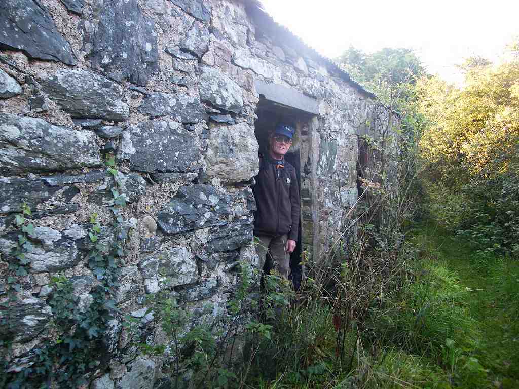
 We came to a derelict milking parlour, and found a place inside to sit
down and eat our pasties. There were big
holes in the roof and rubbish everywhere, it was a sad sight. Further on we passed some cottages which were
being restored, so at least there is some life left in the place.
We came to a derelict milking parlour, and found a place inside to sit
down and eat our pasties. There were big
holes in the roof and rubbish everywhere, it was a sad sight. Further on we passed some cottages which were
being restored, so at least there is some life left in the place.

 We came out on to a narrow lane just beyond a hedge-cutter, and were
relieved we could turn the other way and not have to pass it — there wasn’t
much room. We passed a pair of ornate
gates, then turned along a track which led us downhill towards the Menai Strait.
We came out on to a narrow lane just beyond a hedge-cutter, and were
relieved we could turn the other way and not have to pass it — there wasn’t
much room. We passed a pair of ornate
gates, then turned along a track which led us downhill towards the Menai Strait.
 We passed the skeleton of a dead sheep with
fleece scattered all about. One of the
live sheep in the flock was limping badly, and we had seen another like that
further back. We wondered how well they
were being looked after. Then we passed
a herd of cows who stood in a row looking at us with lugubrious faces.
We passed the skeleton of a dead sheep with
fleece scattered all about. One of the
live sheep in the flock was limping badly, and we had seen another like that
further back. We wondered how well they
were being looked after. Then we passed
a herd of cows who stood in a row looking at us with lugubrious faces.
 At the end of the field there were steps down to the beach. This was a ferry point across the Menai Strait
to Caernarfon in times gone past. A
notice told us: “As Tal-y-Foel became increasingly isolated by shifting sands in the
Strait, the ferry could only reach its pier at high tide. At low tide the ferry would land at Y-Foel,
and at half tide the ferrymen would carry passengers ashore here at
Ty-Bach-y-Foel. Passengers complained
bitterly that an extra charge was being made for this indignity. This, and complaints of overloading the
ferry, and the reluctance of the ferrymen to leave the taverns of Caernarfon, conjures
up a picture of Victorian ladies being charged extra to be manhandled by
drunken ferryman after a hair-raising trip in an overloaded boat.” The ferry service was suspended in 1852, but
the house was occupied for another hundred and two years. The house is now roofless, and so covered in
brambles we had difficulty in locating the ruin. There were scant remains of the jetty on the
stony beach.
At the end of the field there were steps down to the beach. This was a ferry point across the Menai Strait
to Caernarfon in times gone past. A
notice told us: “As Tal-y-Foel became increasingly isolated by shifting sands in the
Strait, the ferry could only reach its pier at high tide. At low tide the ferry would land at Y-Foel,
and at half tide the ferrymen would carry passengers ashore here at
Ty-Bach-y-Foel. Passengers complained
bitterly that an extra charge was being made for this indignity. This, and complaints of overloading the
ferry, and the reluctance of the ferrymen to leave the taverns of Caernarfon, conjures
up a picture of Victorian ladies being charged extra to be manhandled by
drunken ferryman after a hair-raising trip in an overloaded boat.” The ferry service was suspended in 1852, but
the house was occupied for another hundred and two years. The house is now roofless, and so covered in
brambles we had difficulty in locating the ruin. There were scant remains of the jetty on the
stony beach.


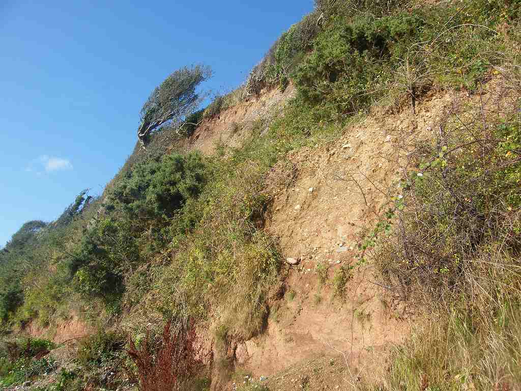
We walked for half a mile along the beach and didn’t find the shingle too demanding. It was well packed down. The cliffs were sandy with stones in, and the isolated trees looked very wind-blown. The path continued along a tarmacked lane.
 We sat on a memorial bench to eat our sarnies
and apples. We had views of Caernarfon
on the opposite side of the Strait, but a bright low sun was behind the town so
it was difficult to look that way.
We sat on a memorial bench to eat our sarnies
and apples. We had views of Caernarfon
on the opposite side of the Strait, but a bright low sun was behind the town so
it was difficult to look that way.
A huge black cloud appeared as we were eating, so I put on my wet-weather gear. Colin didn’t, saying it was “nothing”. When the road turned inland, we continued straight ahead on a footpath alongside fields. Eventually we entered a wood. The black cloud had disappeared by then, so I removed my wet-weather gear — Colin had been right with his ‘nothing’ analysis. It was a real pastoral scene as we descended across a field to a road.
 There we had a choice of routes — should we go a little bit inland across
fields or risk the beach again? While we
were making up our minds a lorry came careering down the road and screeched to
a halt when it reached a stationery car parked in the way. Meanwhile a Landrover drove up from the
beach, and the driver asked us if we had seen two Shetland ponies. We hadn’t, and the Landrover drove off into a
field while the lorry stayed where it was, too wide to pass the car. Both drivers were anxiously looking for their
lost animals — I hope they found them.
There we had a choice of routes — should we go a little bit inland across
fields or risk the beach again? While we
were making up our minds a lorry came careering down the road and screeched to
a halt when it reached a stationery car parked in the way. Meanwhile a Landrover drove up from the
beach, and the driver asked us if we had seen two Shetland ponies. We hadn’t, and the Landrover drove off into a
field while the lorry stayed where it was, too wide to pass the car. Both drivers were anxiously looking for their
lost animals — I hope they found them.
We decided to risk the beach and started walking down there. Another black cloud appeared which Colin again dismissed as “nothing”. But it started raining, hard, he had been wrong about this cloud! We both hurriedly donned full wet-weather gear, and put our cameras away. The Landrover emerged from an adjacent field — he still hadn’t found his lost ponies. I wonder if they had been stolen.
 At the beach we found a good track which led us through woods just above
the top of the beach. If only it would
last — it didn’t! All too soon it spat
us out on to the stony beach, but the shingle was pretty packed down and it wasn’t
difficult to walk. It was quite windy
now that we were exposed to the Strait, but the rain didn’t last long. We were reluctant to take off our wet-weather
gear because it was so wet, so we just loosened it and let it flap in the
wind. The Strait was quite narrow at
this point, hardly more than river-width.
At the beach we found a good track which led us through woods just above
the top of the beach. If only it would
last — it didn’t! All too soon it spat
us out on to the stony beach, but the shingle was pretty packed down and it wasn’t
difficult to walk. It was quite windy
now that we were exposed to the Strait, but the rain didn’t last long. We were reluctant to take off our wet-weather
gear because it was so wet, so we just loosened it and let it flap in the
wind. The Strait was quite narrow at
this point, hardly more than river-width.
 The sun came out as we left the beach, which had become impossible, and
followed a muddy path up to the main road.
It was quite a slog uphill, we didn’t enjoy it and we were not looking
forward to the main road. But a lovely
rainbow filled the sky as we emerged on to the tarmac — that cheered us up!
The sun came out as we left the beach, which had become impossible, and
followed a muddy path up to the main road.
It was quite a slog uphill, we didn’t enjoy it and we were not looking
forward to the main road. But a lovely
rainbow filled the sky as we emerged on to the tarmac — that cheered us up!
 We removed our partially dry wet-weather gear and put on high-viz
waistcoats. We both hate traffic-dodging along
main roads, and we could have taken the official coast path which went a lot
further inland at that point. But it was
a much longer distance to walk, and we were tired. To add to our misery, it started to rain
again. But it wasn’t much and it soon
stopped. It produced a bit of a rainbow
again, but that was only momentary.
We removed our partially dry wet-weather gear and put on high-viz
waistcoats. We both hate traffic-dodging along
main roads, and we could have taken the official coast path which went a lot
further inland at that point. But it was
a much longer distance to walk, and we were tired. To add to our misery, it started to rain
again. But it wasn’t much and it soon
stopped. It produced a bit of a rainbow
again, but that was only momentary.
 After about a mile we were joined by the official coast path again. Because nowhere else could be found to put
the coast path along this stretch, the edge of the adjacent fields had been
commandeered to site the path, and there was now a wall between us and the
traffic. An end to car-dodging, for this
Walk at least — hooray! It was a bit
overgrown and squidgy at first, but further on we were walking on new
boardwalks — well done the coast-path people!
The rain kept coming and going, so I fished out my cape again. Further on we were on pavements, and passed a
spectacular entrance to a National Trust property. Also we crossed a footbridge over a stream
which was right next to the road.
After about a mile we were joined by the official coast path again. Because nowhere else could be found to put
the coast path along this stretch, the edge of the adjacent fields had been
commandeered to site the path, and there was now a wall between us and the
traffic. An end to car-dodging, for this
Walk at least — hooray! It was a bit
overgrown and squidgy at first, but further on we were walking on new
boardwalks — well done the coast-path people!
The rain kept coming and going, so I fished out my cape again. Further on we were on pavements, and passed a
spectacular entrance to a National Trust property. Also we crossed a footbridge over a stream
which was right next to the road.
As the road led steeply down towards the shore, we came to a gate in a wall with a notice about a ‘permissive path’. It said the path was only open between dawn and dusk, and only at low tide. As we descended steep steps we hoped the tide wasn’t too far in. It wasn’t — it had ebbed enough for us to get round. We descended to sea level in brilliant sunshine.

 Across a small inlet was a huge
boat moored by a small cottage — we reckoned the boat was worth more than the
house! The steps led down to a concrete
path along the bottom of a high wall.
Across a small inlet was a huge
boat moored by a small cottage — we reckoned the boat was worth more than the
house! The steps led down to a concrete
path along the bottom of a high wall.
We went round a corner to a little jetty which was chained off. There we caught our first sight of Britannia Bridge.

 Colin was interested in the fossils in the stones which held up the
concrete path, but I reminded him that they might not be local since they were
part of a manmade structure — we didn’t know where they had been sourced. We descended to the beach which was packed
stone and no trouble to walk.
Colin was interested in the fossils in the stones which held up the
concrete path, but I reminded him that they might not be local since they were
part of a manmade structure — we didn’t know where they had been sourced. We descended to the beach which was packed
stone and no trouble to walk.
 There is a statue of Nelson on a plinth just there. A couple from Australia were looking at it and
asked us if we knew why it was there. We
didn’t, so one of them tried to look it up on the internet using her tablet. She didn’t find an answer to her
question. The only link I can think of
which Nelson has with this area is that he once said the Menai Strait
was one of the most difficult bits of sea to navigate because of the strong
currents and tides.
There is a statue of Nelson on a plinth just there. A couple from Australia were looking at it and
asked us if we knew why it was there. We
didn’t, so one of them tried to look it up on the internet using her tablet. She didn’t find an answer to her
question. The only link I can think of
which Nelson has with this area is that he once said the Menai Strait
was one of the most difficult bits of sea to navigate because of the strong
currents and tides.
 We left the beach by
the Nelson statue and walked up through a churchyard to the car park by the
church where our car was waiting.
We left the beach by
the Nelson statue and walked up through a churchyard to the car park by the
church where our car was waiting.
That ended Walk no.347, we shall pick up Walk no.348 next time in the church car park at Llanfairpwllgwyngyllgogerychrndrobyllllantysiliogogogoch. It was four o’clock, so the Walk had taken us six hours twenty minutes. We had our tea and chocolate biscuits, and then it started to rain — cats and dogs, it pelted down for several hours! We couldn’t believe our luck in finishing the Walk in time! But we still wanted to photograph the nameboard at the local station. We drove there, but there was no way we were going to get out of the car in that torrent! Fortunately the old nameboard was displayed on the end of a building, so Colin parked facing it and I took the picture through the windscreen with the wipers going like the clappers!
 Then we returned to our cosy
cottage, relieved we weren’t in the caravan and didn’t have to take an awning
down!
Then we returned to our cosy
cottage, relieved we weren’t in the caravan and didn’t have to take an awning
down!
The next day we packed up and returned to our home in Malvern.
At the end we came to our car parked by the church. We had our tea and chocolate biscuits, drove to the station in the pouring rain to take a photo of the nameboard of this famous village, then we returned to our cosy cottage.
The next day we packed up and returned to our home in Malvern.


We said “Hello!” to a couple of ponies at a field gateway. The light was beautiful, with bright sun low in the sky. It felt good to be out in the countryside!


We walked for half a mile along the beach and didn’t find the shingle too demanding. It was well packed down. The cliffs were sandy with stones in, and the isolated trees looked very wind-blown. The path continued along a tarmacked lane.
A huge black cloud appeared as we were eating, so I put on my wet-weather gear. Colin didn’t, saying it was “nothing”. When the road turned inland, we continued straight ahead on a footpath alongside fields. Eventually we entered a wood. The black cloud had disappeared by then, so I removed my wet-weather gear — Colin had been right with his ‘nothing’ analysis. It was a real pastoral scene as we descended across a field to a road.

We decided to risk the beach and started walking down there. Another black cloud appeared which Colin again dismissed as “nothing”. But it started raining, hard, he had been wrong about this cloud! We both hurriedly donned full wet-weather gear, and put our cameras away. The Landrover emerged from an adjacent field — he still hadn’t found his lost ponies. I wonder if they had been stolen.


As the road led steeply down towards the shore, we came to a gate in a wall with a notice about a ‘permissive path’. It said the path was only open between dawn and dusk, and only at low tide. As we descended steep steps we hoped the tide wasn’t too far in. It wasn’t — it had ebbed enough for us to get round. We descended to sea level in brilliant sunshine.


We went round a corner to a little jetty which was chained off. There we caught our first sight of Britannia Bridge.


That ended Walk no.347, we shall pick up Walk no.348 next time in the church car park at Llanfairpwllgwyngyllgogerychrndrobyllllantysiliogogogoch. It was four o’clock, so the Walk had taken us six hours twenty minutes. We had our tea and chocolate biscuits, and then it started to rain — cats and dogs, it pelted down for several hours! We couldn’t believe our luck in finishing the Walk in time! But we still wanted to photograph the nameboard at the local station. We drove there, but there was no way we were going to get out of the car in that torrent! Fortunately the old nameboard was displayed on the end of a building, so Colin parked facing it and I took the picture through the windscreen with the wipers going like the clappers!

The next day we packed up and returned to our home in Malvern.


