Thursday, September 13, 2012

Walk 314 -- Barrow-in-Furness to Walney Island

Ages:  Colin was 70 years and 128 days.  Rosemary was 67 years and 271 days.
Weather:  Grey to very grey with a cold wind.
Location:  Barrow-in-Furness to Walney Island.
Distance:  1½ miles.
Total distance:  3200 miles.
Terrain:  Cycle path.  Undulating, some steps.
Tide:  In.
Rivers: None.
Ferries:  None.
Piers:  None.
Kissing gates:  None.
Pubs:  None.
‘English Heritage’ properties:  None.
Ferris wheels:  None.
Diversions:  None.
How we got there and back:  We were staying in our caravan near Grange-over-Sands.  This morning we drove to Barrow-in-Furness and parked in a small car park where we officially ended the Walk yesterday.
At the end we finished the Walk at the bridge over to Walney Island.  We turned round and walked back as it wasn’t far.  We had intended doing some walking on Walney Island, which is really only a sand-spit.  But it started to rain, and we were both very tired after all the miles we have packed in over the past two-and-a-half weeks.  So we decided to call the bridge a dead end we didn’t have to walk if we didn’t want to, and drove round the island instead!
The next day we towed the caravan back home to Malvern.  We shall start the next Walk at the bridge over to the island.

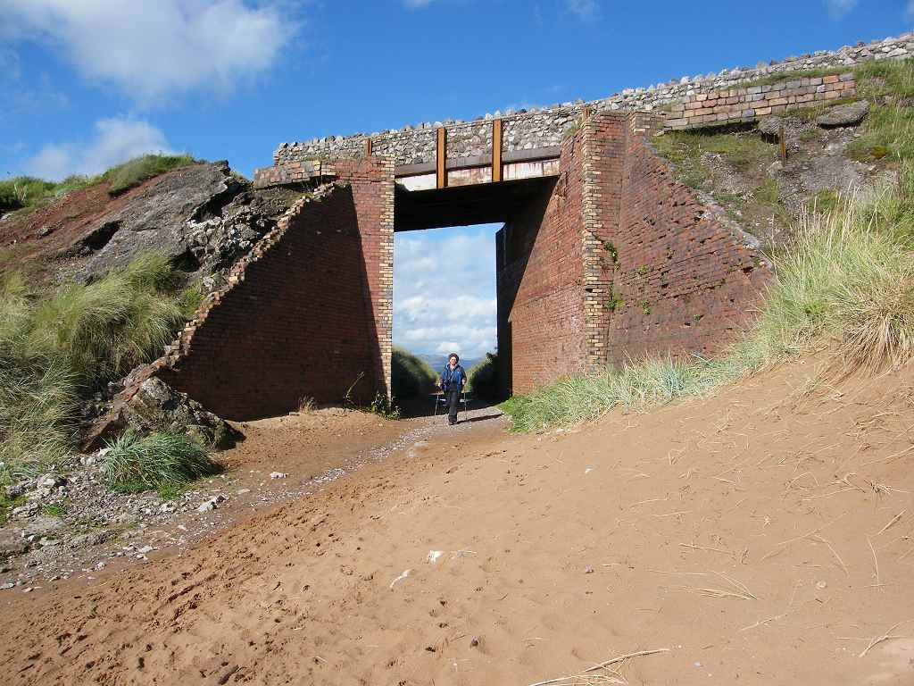
There was a small car park leading off the main road where we finished the last Walk, which we made use of today.  It was in a bit of ‘old road’.  From there a path-cum-cycleway led down under the railway, then up and round to an old quarry.  We looked to our right, and saw why we couldn’t have walked along the beach to this point yesterday instead of squirming through that scratchy undergrowth to get out to the road — there was no beach this end!
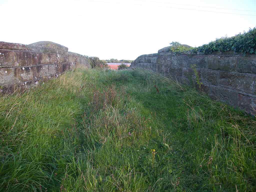
In front of us was supposed to be a Byway Open to All Traffic (BOAT), which is marked on the map as going across the channel to Walney Island.  From where we were standing there was no sign of it except for a single post in the middle of the channel.  Of course, the tide was in — it may have looked better if it had been low tide.
We turned left and followed a tarmacked cycleway up over a small hill.  We couldn’t think why the Cumbrian Coastal Path is signposted to continue down the main road instead of along this lovely easy path by the waterfront.  It was cold and windy at the top, it felt like winter — come off it, it’s only September!  The sky was very grey making everything seem gloomy, but the rain held off.  We went down some steps to where footbridges are supposed to take a footpath across the channel to Walney Island, but like the BOAT, there was no sign of it.
We continued along the path which was paved in red bricks.  A notice told us that this pathway, which was only opened in 1998, was called “Red Man’s Walk” after the men who worked in the local iron and steel industry.  The processes of that industry often left them covered in red dust.  The sculpture of a working man had been vandalised so that only the legs and feet remained.  How sad that the modern generation, who will never have to work so hard in such difficult conditions for a pittance, have such little respect for the industry of their forefathers.
We came to the Docklands Museum which was free entry.  We are not ‘museum people’ and only went in to use the toilets!  But we couldn’t tell the warden that when he started to talk to us enthusiastically about the exhibits.  So I asked him about the ways across the Walney Channel.  He told us they are still there at low tide — he’d crossed the footbridges himself only last week.  About the BOAT he said, “You would need wellies!” but the footbridges could be done in trainers.  He admitted they were both in a poor state of repair, and if something wasn’t done soon they’d be lost.
He also explained that the building of the docks in the 19th century washed away most of the walkways, isolating the residents of Walney Island unless they had a boat.  In 1887 the dock owners (the Furness Railway) provided a chain ferry across the channel.  In 1908 the ferry was replaced by a bridge.  This was a toll bridge until 1935 when, in honour of the silver jubilee of King George V, the toll was lifted.
We had a cursory look round the museum, but it was too full of ‘history’ rooms done out like our childhood kitchens — it made us feel old!  A painting of a ship caught Colin’s eye because it was called ‘The Duke of Devonshire’.  (Colin was brought up on the Duke of Devonshire’s estate in Derbyshire.)  Apparently the seventh Duke wanted Barrow to develop into a major port and had this ship built as part of a fleet of six to trade with India.  This plan never came to fruition, but shipbuilding at Barrow prospered.
We thought the museum building was more interesting than the exhibits!  A great example of modern architecture — at least from the inside — it has been built inside a dry dock.
Outside, we walked round a loop of a jetty where some fishing boats were moored, then through some very pleasant gardens to the bridge.  We walked over the bridge and back.


That ended Walk no.314, we shall pick up Walk no.315 at the bridge over the Walney Channel in Barrow-in-Furness.  It was midday, so the Walk had taken us one and a half hours.  We turned round and walked back to the car, it wasn’t far.  We fully intended to do some walking round Walney Island — which is really a sand-spit — in the afternoon, but just as we got back to the car it started raining.  We ate our lunch in the car, and the rain continued.  Also the wind was very cold, it felt like winter!  We were extremely tired after two and a half weeks of hard walking during which we had covered 133 miles of coastline!
All in all, we decided it was too much, so we drove round Walney Island instead.  (We called the bridge, the only way on to the island at high tide, a dead end which we didn’t have to walk unless we wanted to.)  On the island it was mostly housing estates and flooded roads — there was also a small airport. There were some nice beaches on the outer fringe, but it was too cold and wet to enjoy them.
The only thing of interest was the view of Piel Island from the southern end — more about this fascinating islet, which claims independence from Great Britain, on my next Walk write-up.  It is said that you can walk to it from Walney Island at very low tide, but it is dangerous.
The next day we towed the caravan back home to Malvern.

Wednesday, September 12, 2012

Walk 313 -- Foxfield to Barrow-in-Furness

Ages:  Colin was 70 years and 127 days.  Rosemary was 67 years and 270 days.
Weather:  Heavy rain for the first 3 to 4 hours.  It eventually eased to clear skies with scudding clouds.  A cold breeze.
Location:  Foxfield to Barrow-in-Furness.
Distance:  13½ miles.
Total distance:  3198½ miles.
Terrain:  Lanes.  Grassy paths.  Muddy paths.  Tracks, some muddy.  Top of estuary beach.  Flat.
Tide:  Out when it mattered.
Rivers: None.
Ferries:  None.
Piers:  None.
Kissing gates:  Nos 390, 391 and 392 when crossing back and forth across the railway.
Pubs:  None.
‘English Heritage’ properties:  None.
Ferris wheels:  None.
Diversions:  None.
How we got there and back:  We were staying in our caravan near Grange-over-Sands.  This morning we drove to Barrow-in-Furness and parked about half a mile from the station.  We caught a train to Foxfield, and started the Walk from the station as it is situated directly across the estuary from where we finished the last Walk.
At the end we finished the Walk on the main road into Barrow, about a mile from where we had parked the car.  So we walked down the cycleway-cum-pavement to where it was parked.  After tea and biscuits we returned to our caravan.

After alighting from the train, we crammed ourselves into the tiny wooden waiting room at Foxfield Station to put on our wet-weather gear.  Colin noticed a swallows’ nest in the roof with three chicks in it and a fourth perched on a rafter.  They looked almost mature enough to fledge, and there was lots of chirping because we were there.  Colin was worried that this late brood had been abandoned, but then a parent flew in with food, quite unfazed that we were sitting below.
It rained frenetically for the first three hours of today’s Walk, so we were unable to take any pictures for the first few miles.  From the station we followed the main road on a pavement for about a hundred yards, then we crossed the railway on to a quiet lane.  We met another couple walking towards us (of about our age) so we weren’t the only idiots out walking in this atrocious weather.  They seemed to be quite cheerful about the wet even though the man was wearing a non-waterproof fleece.  He must have been soaked through!  After about a quarter of a mile we crossed back over the railway, and the same couple caught us up and passed us — returning to their local home, we supposed.
The lane zigzagged through the countryside, up a little hill and down, until we turned off at a farm.  We crossed a small river and took a footpath across some fields.  We did wonder how deep we were going to sink into the mud considering the amount of rain we’ve had recently, but to our surprise it was not muddy — only a trifle squelchy.  There were a few ditches to cross, but all of them had footbridges so we got across with dry feet.
We came out on to a road and walked down to Kirkby-in-Furness Station.  There we sat in the waiting room on the first platform we came to so we could get out of the rain to eat our pies.  But this shelter was fairly open and very draughty, so we crossed over to the other platform where the shelter was more substantial.  There was a man inside painting it, but he didn’t mind us sitting there.  He told us he used to work in an office and hated it.  Now he paints railway stations for less money, but he is much happier!
The path continued alongside the railway on the estuary side.  The wind was strong here and blowing rain into our faces.  It was not nice!  The path was uneven and muddy.  At one point it had eroded away completely, the railway having been built up with big rocks.  We had to go down on to the ‘beach’ which was slippery.  I hated it, and had difficulty getting up the other side — I can’t do big steps any more.
We were very unhappy because of the rain in our faces, and the wind was so strong.  We decided to go inland at the next railway crossing and follow a parallel path across fields.  So we did this at Soutergate.  As soon as we got off the beach the wind was considerably reduced though the rain was just as intense.  The paths across the fields were not well way-marked which made navigation problematic.  It was muddy in places, and we found it difficult to negotiate our way round the gooey patches.  There were lots of stiles which I find increasingly tricky to climb over as I get older and my back gets stiffer.  In the wet the wood is slippery and the steps are usually too big.  We made very slow progress.
Colin was grumpy and I was dead miserable, ready to throw in the towel there and then.  We got to a field in which there seemed to be no way out.  We walked along the hedge looking for a gap, but we couldn’t see one.  Suddenly the rain stopped, the wind dropped and the sky cleared.  The sun came out, it was a different world!  We couldn’t believe how quickly the situation changed — from the depths of despair our mood rose to dizzying heights.
And we found the stile — it was collapsed inside an overgrown hedge hidden from view until we got right up to it.  We struggled through, then walked down a very muddy lane (this was rather horrid) to Marsh Grange.  Behind us, as the clouds melted away, we could see the hills of the southern Lake District for the first time today. 
We decided to return to the beach now that the weather had so dramatically improved.  We walked down a lane towards a golf club where we sat on a wall to eat our sarnies.  Then we crossed the railway for the umpteenth time and struck out towards a small hill.  We didn’t climb the hill, a sort of grass-covered rock in the estuary, but turned south when we reached it.
We were walking on the marsh which was a little squelchy underfoot, but not too bad.  The path divided — the left fork was labelled “Preferred Route” but that went back across the railway and we didn’t want to do that.  The right fork warned us, “This route has natural hazards”.  It went the way we wanted to go, so we decided to risk them.  But the path almost immediately got too boggy, so we had to retreat.  Then we found an unofficial path in between the two which went along the edge of the marsh without crossing the railway — ideal!  We followed this for over a mile without getting our feet wet or sinking into the bog.
As we passed the inevitable golf course, we were amused to see sheep grazing on the greens — there’s rural for you! 
We could see Millom across the estuary, and further back the hamlet of Lady Hall where we really finished the last Walk.  Behind us we could see the mountains of the Lake District, and beyond the estuary we could see hundreds of windmills in the sea.
We came to a picnic site at Askham where we sat on black rock seats to eat our first chocolate.  The beach here was firm and sandy, our favourite walking environment, and there were a lot of people out walking their dogs.  There were a couple of ships beached on the marsh, they were being used as houseboats.
 We walked towards the strange Askham “Pier”, a huge construction of rocks leading out to a deeper channel in the estuary.  It was apparently built from slag, a waste product of the 19th century iron ore furnaces.  We were relieved to find a bridge had been put in so we could walk under it at the top of the beach — no climbing involved.
We found we were on our own after that, for another mile or so until we reached the next car park.  Beautiful beach, but no one walking it, except us.
We passed some big heaps of black stones — don’t think it was coal — at the top of the beach. Don’t know what they were, perhaps remnants of the defunct iron ore industry.
We approached the dunes, but it was difficult to see the way through them to the car park where we knew there was a toilet block.  We followed a muddy track and we eventually found it.  But we couldn’t use it.  It was a wooden shack, but it was locked up with police “crime scene” tape wrapped round it.  There were signs of fire inside — obviously someone’s idea of fun to set fire to a toilet block.  We had to find a bush in the dunes instead.
We removed our kags and overtrousers because the rain had completely gone and it was now very hot.  We were both overtired which made us argumentative.  Neither of us wanted to walk the perimeter of the dune nature reserve because it was too far.  That point we did agree on.  I wanted to go a little bit inland and take a path across fields.  Colin wanted to take a footpath straight across the dunes.  We have got disorientated and lost in dunes so many times before and this path, like many, was not clearly way-marked.  But he wouldn’t listen to reason and strode off in the wrong direction along the top of the beach.  I got out the compass, but he refused to look at it.  I said we were on the top of the beach walking westwards, not cutting through the dunes southwards as the path seemed to do on the map.  He replied that there was no difference between the beach and the dunes, it was all sand.  He seemed to have a mind-block, and got all miffy about having to carry the map.
I’d had enough by then, I was too tired to go any further in the wrong direction, or argue any more with such unreasonableness.  I snatched the map from him, made him carry my sticks because I couldn’t carry both, and insisted we did the inland route because I was now the navigator.  He complained that the field path would be muddy and difficult to navigate, but it wasn’t.  It turned out to be a good track, mostly concrete and it was waymarked very clearly.  We made good time across it, but even then Colin wouldn’t concede that it had been a good route.  What can you do with such obstinacy?
We passed some farmers mending a fence. Then the track turned inland and would have taken us to a road which is what we didn’t want to do.  We sat on a stile to eat our apples.  Colin was in a much calmer mood by now, and we were able to discuss in a reasonable manner how we should proceed.  We decided to continue along the beach even though it looked a bit wild and uggy.  This was always going to be the most dodgy part of the Walk.  We couldn’t make up our minds whether the next mile or so of beach was an unofficial path or the neglected Cumbrian Coastal Way.
We went up past the back of some factories, then down to the beach again.  We passed two Second World War pillboxes — one was teetering on the edge of a soft cliff and the other was already on the beach perched on its side.  Well, they weren’t meant to last seventy years!
Fortunately the tide was well out, and we managed to find a way through on the beach which wasn’t too slippery or stony.
We knew we had to cut in somewhere before we reached the end of the beach and walk out to the road.  This was because the beach deteriorated and eventually got swallowed up into a disused industrial sandpit.  It was difficult to see where the gap was since everything was so horribly overgrown, but two people out on the beach with a dog gave us a clue — they must have come through the gap.  We found it — overgrown with lots of stinging nettles which we had to battle our way through.
We came out by some industrial buildings and turned right along a concrete track.  A signpost pointed the public footpath the way we were going, but we came to a gate with an awkward fastening.  Colin negotiated it, and we carried on.  We were alongside the railway once again.  Colin looked up and said we should be up on that bridge over the railway that we had just passed.  We couldn’t see any way up to it, just fences, brambles and stinging nettles.  We decided to carry on, but soon we came to a locked gate — leading to a waste water plant!
We had no choice but to turn back, negotiating the gate with the awkward fastening again.  Next to it, almost completely hidden by overgrown bushes, was another gate which was leaning awkwardly.  This, apparently, was the public footpath.  But this gate could not be opened at all because there was a haystack leaning against it on the other side!
There was also a notice warning us to keep off the newly sown grass seed’s!  Where?  And what did the grass seed possess that was so precious we must keep off it?
We sort of fell over the gate inelegantly and squeezed round the haystack.  The path up to the bridge was overgrown with twelve-foot high gorse, brambles and nettles.  We had to get through, there was no other way, so we bashed at it with my sticks as we slowly made our way up the bank.  We scratched our faces and stung our hands, but we got there!
The humpy bridge was lined with long grass and OK to cross, but the path the other side wasn’t much better than the first one.  We battled our way through, crossed a field and out to the road.  There we followed a cycle path for about a mile to the point where there was a small car park on a bit of ‘old’ road.

That ended Walk no.313, we shall pick up Walk no.314 at the small car park on the A590 just to the north of Barrow-in-Furness.  It was quarter to eight, so the Walk had taken us nine hours.  We walked about a mile down the cycleway-cum-pavement to where our car was parked in a back street.  After tea and biscuits we returned to our caravan near Grange-over-Sands.

Monday, September 10, 2012

Walk 312 -- Millom to Foxfield

Ages:  Colin was 70 years and 125 days.  Rosemary was 67 years and 268 days.
Weather:  Dull and grey plus a torrential shower.
Location:  Millom to Foxfield.
Distance:  5 miles.
Total distance:  3185 miles.
Terrain:  Good straight path along a seabank.  Flat.
Tide:  Coming in.
Rivers: No.386, Black Beck.  No.387, Duddon Estuary (which the railway crossed and we pretended).
Ferries:  None.
Piers:  None.
Kissing gates:  None.
Pubs:  None.
‘English Heritage’ properties:  None.
Ferris wheels:  None.
Diversions:  None.
How we got there and back:  We were staying in our caravan in St Bees.  We had already done another Walk in the morning followed by a pub lunch.  We drove on to Millom where Colin left me with my puzzle book to while away an hour or so.  Meanwhile he drove on to the hamlet of Lady Hall where he parked, removed his bike from the boot of the car and cycled back.
At the end we got as near as we could to the railway viaduct across the Duddon Estuary with Foxfield Station directly on the other side.  We cut across fields to Lady Hall and our car.  After tea and biscuits, we drove back to Millom to pick up the bike, then back to our caravan in St Bees.
The next day we moved our caravan to Meathop Fell, near Grange-over-Sands.

We went straight on to the seabank along the Duddon Estuary to start this Walk.  It was a good path — Colin could have cycled it in the other direction which may have been easier than the road route which he took — but it was very straight and a bit boring.  At the beginning we were following a man with a dog, but they turned back after about half a mile.  We then met a spattering of other people which is unusual on our Walks.  There were two girl joggers amongst them, one of whom was over-weight and struggling.  But at least she was out there doing it — good luck to her.
We had marshes to the right of us and the railway to the left.  One or two trains went past, but nothing very exciting happened.  So we marched quickly on until we got to the road leading to Green Road Station.
We probably could have carried on the seabank from there, but the official Coastal Way went inland at this point.  We decided to follow it because it was less exposed to the elements — what prompted this decision was the fact that it began to rain, torrentially!  We sheltered under a tree for a while hoping that it would stop, but it didn’t.  So we carried on and got wet.
Before we reached the station we turned north on a farm track.  This took us across a small river, then up on the seabank again.  We could have stayed on it after all, but it didn’t really make any difference.  The rain eased, and eventually stopped.
We went round a bend and could see the railway bridge across the River Duddon.  Foxfield is just beyond the further end of the bridge, but there is no footway across.  We came up close to it and saw that it was blocked off by a fence and weeds.  For a moment we thought there was no way on, but then we noticed a stile into a field down at the bottom of the bank to our left.  The path from this stile led to a tunnel under the railway and away from the river.
It was a short climb up a couple of fields to the hamlet of Lady Hall where our car was parked.  Once again we pretended we had crossed the railway bridge, using our new additional rule no.20.  It saved us walking four or five miles extra to cross the river on a road bridge.

That ended Walk no.312, we shall pick up Walk no.313 next time at Foxfield Station.  It was half past six, so the Walk had taken us two hours.  After partaking of tea and biscuits, we drove back to Millom to pick up the bike, then back to our caravan in St Bees.
The next day we moved our caravan to Meathop Fell, near Grange-over-Sands, a much nicer and better run caravan site than either of the other two we have stayed at this session.

Saturday, September 08, 2012

Walk 311 -- Ravenglass to Millom

This Walk was done in three parts — a, b and c.
Dates:  a and b: 07 September 2012.  c: 08 September 2012.
Ages:  a and b: Colin was 70 years and 122 days.  Rosemary was 67 years and 265 days.  c: Colin was 70 years and 123 days.  Rosemary was 67 years and 266 days.
Weather:  a: Cloudy but dry.  Quite warm. Breezy.  b: Brightening up.  Breezy but warm.  c: Dull, then misty with a lot of moisture in the air.  Later, brightening up, but no sun until the evening.  Hot and humid.  Visibility very poor.
Location:  Ravenglass to Millom.
Distance:  20 miles.
Total distance:  3180 miles.
Terrain:  a: Some beach which was squidgy and slippery because it is really an estuary.  Good path past Roman baths.  b: Quiet road.  Straight, flat and boring!  c: A lot of beach — some with lovely firm sand and some with shingle.  Grassy cliff paths and dune paths.  Flat on the beach, slightly undulating on cliff paths.
Tide:  a: Coming in.  b: In.  c: Out, coming in.  Then out again before we’d finished.
Rivers:  a: No.383, River Esk (railway viaduct which we pretended to cross).  b: None.  c: No.384, River Annas.  No.385, Haverigg Pool.
Ferries:  None.                              Piers:  None.
Kissing gates:  a: No.387 where we gave up on the beach.  b: None.  c: Nos. 388 & 389 around Millom (both locked!)
Pubs:  None.
‘English Heritage’ properties:  No.46, the Roman bath-house near Ravenglass.
Ferris wheels:  None.                    Diversions:  None.
How we got there and back:  We were staying in our caravan in St Bees. 
a: We drove to Ravenglass and parked at the station from where we started the Walk.  At the end we walked back as it was only a short distance.
b: We drove to the other end of the railway viaduct across the River Esk.  Colin dropped me off, then drove 2½ miles down the road where he parked, took his bike out of the boot and cycled back.  At the end we came to the car.  We picked up the bike as we drove back to the caravan.
c: We drove to Millom and parked near the station.  We caught a train to Bootle, then we walked a mile up the road until we came to the beach where we had finished the second part of the Walk yesterday.  At the end we walked up the road about 100 yards to the car, and drove back to St Bees.

(a)  From the railway bridge at Ravenglass (the one with a footbridge attached) we walked along the greensward between the beach and the village.
There were arrows pointing us on to the beach because that is where the coastal path is, but it looked too stony and slippery to walk with any comfort.  It is really an estuary, so it is mud rather than sand.  We went slightly inland and used the footpath which led to the Roman ruins instead.
Roman  Bath House,  Ravenglass 
These ruins are part of a bath house believed to have been built by the Romans around AD130.  Apparently they are among the tallest Roman structures surviving in northern Britain, but they are only a fragment of the original building.  The bath house was built adjacent to a fort which has long since disappeared.  It is likely that there was a small harbour where the village of Ravenglass now stands, and the fort was built to guard it.
From the bath house, we took a track which led under the railway to the beach.  From here on we had no choice but to walk on the mud.  It was a bit slippery underfoot so we had to take it carefully — I was glad I had my walking poles to steady me.  We were walking on clay, and there were several streams, some were a bit dodgy to cross.  But we coped.
It was less than a mile to the mouth of the River Esk, so it didn’t take us long to get there.  The ‘path’, such as it was, curled round and under the railway.  That is where we left it.  To cross the river on the official coast path would have meant a five mile detour inland, yet here in front of us was a railway bridge going straight across.  This one didn’t have a footbridge attached, so we made up a new rule that we could count it as a disused ferry and therefore follow additional rule no.13.  Marked on the OS map is a footpath leading straight across the river, the word ‘ford’ is written.  We looked at the marsh, then at the full running river, and decided that only an utter fool would risk it.  There was absolutely no sign of such a path on our side of the river.
We retraced our steps, back to our car parked in Ravenglass.
=  ::  =  ::  =  ::  =  :: =  ::  =  :: =  ::  =  ::  =  ::  =  :: =  ::  =  :: =  ::  =  :: =  ::  =  ::  =  ::  =  :: =  ::  =  
(b) 
On returning to the car, we drove round to the southern end of the railway bridge.  Here even the lane leading under the bridge was flooded, but a man walking his dog was paddling through so we could see that it wasn’t too deep to drive the car through.  Yet here was a wooden signpost pointing into the river as if there was a footpath across.  You’ve got to be joking!
Whilst waiting for Colin to take the car two and a half miles down the road and cycle back, I looked around for somewhere to sit down.  There was mud everywhere, it was very wet.  I walked a few yards down towards the nature reserve (which was out on a sandbank) and looked at a little wooden bridge over a ditch.  I looked at an old boat sitting on the marsh grass.  But there was absolutely nowhere that I could park myself, so I decided to start walking.  (I find it much more tiring to stand about than I do to walk.)
After only about a hundred yards I met Colin coming back on his bike.  He cycled on to lock up his bike near the railway bridge and walk back.  He always says he walks faster than me, but I had walked two miles before he caught me up.
It was a bit of a boring road — perhaps that’s why I walked quicker.  It was straight, and we were not on the coast because we had to walk behind a slice of MOD land.  The fence was festooned with KEEP OUT notices, and military type buildings abounded.  It’s all run by Qinetiq now, as at Farnborough and Malvern.  There was no one about, and the warning flags were down and tied up.
The most interesting feature was a stone wall on the other side of the road — this is a measure of how boring this part of the Walk was!  The wall was not quite dry-stone because we could see mortar in it, but it was built from round(ish) boulders — I thought it quite attractive.
Our car was parked beyond the MOD land, at the top of the beach.  There were several other cars parked near ours, and people were walking their dogs on the beach.
We drove back to our caravan in St Bees, picking up Colin’s bike on the way.
=  ::  =  ::  =  ::  =  :: =  ::  =  :: =  ::  =  ::  =  ::  =  :: =  ::  =  :: =  ::  =  :: =  ::  =  ::  =  ::  =  :: =  ::  =  
(c)  We walked straight on to the beach at the point where we had finished part b of the Walk yesterday.  It was sandy at first, but that didn’t last — it never does.
It was hard going on the stones, so Colin looked along the top of the low cliffs and found there was a path up there.  The farmer had erected a new fence further back from the cliff edge because the soft sandstone (glacial till?) was eroding fast.  There was plenty of room between the fence and the cliff, and it was much easier to walk up there on the grass than it was to stumble over the stones down below.
But soon we came to a place where there was no new fence, and the old one was falling off the edge.  This made continuing on top a lot more difficult.  We found a soft eroded part of the cliff which we could climb down to the beach — it wasn’t difficult.  The soft cliffs here are in a bad way, it reminded us of the east coast where houses are actually falling into the sea.  At least there weren’t any buildings here.  We sat on a rock to eat our pie/quiche.
We looked at the map, and realised that the official coast path was actually on top of the low cliffs for several miles hereon.  The stony beach was not walker/friendly, so we only continued until we came to a gap in the cliff made by a stream.
We climbed up.  We had difficulty working out exactly where we were because the paths we came across bore no relationship to the map.  We followed a track which seemed to be going in the right direction.  This led us through a field of cows where one poor mother was bellowing because her calf was in a different field.  We came to a farm, and at last! there was a rare yellow arrow on a gate!  We carried on, more confidently now, through several fields until we came to another gate with no arrows on it at all.  There was no way on, so we went back one field and down a steep slope into a nature reserve.
This consisted of a narrow pond with reeds behind the shingle bank at the top of the beach, a puddle really.  We didn’t see a single bird there, or anything else for that matter.  We left the nature reserve by crossing this ‘river’ on a rather spectacular wooden footbridge.
We found it quite hard going walking through muddy farmers’ fields along the top of the soft cliffs.  There was too much up and down and too few waymarkers.  At one point we were completely stumped.  So we took the only track available which initially took us in the wrong direction, but then sharply turned into a cut cornfield where we climbed a steep slope with the gradual realisation that we were back on top of the cliffs which were behind a hedge.  It was all very confusing!  We sat on a bank to eat our sarnies.
A good track led us downhill past a field containing very unusual sheep.  They were black with white faces — rather beautiful we thought.  At the bottom we saw a gate leading on to the beach, so we took it.
The beach was sandy to start with, nice and firm.  We made excellent time and it was very enjoyable.  Out to sea we could see a whole line of modern windmills — they are springing up everywhere.
The ‘cliffs’ to our left became extremely up & down, we would never have coped if we’d stayed up there.  The slope was so steep where some sheep were grazing that we could see good evidence of soil-creep.
Unfortunately the tide was coming in, so the sand we were so happily walking on ran out.  We tried to outrun the waves at first, but that didn’t work for long.  We tried a sand strip higher up, but that ran out too.  We were forced to cope with stones higher up the beach — hard on the ol’ leg muscles!
Then Colin found a path on the grass bank which appeared right at the top of the beach, and we walked the last hundred yards into Silecroft more comfortably on that.
We sat on a bench to eat our first chocolate.  There was no path on shore leading south from Silecroft, so we had to put up with the stony beach for a while.  We crossed a rusty-red stream cutting its way across the shingle, it must have been full of iron.
Colin was constantly looking up into the grassy dunes, and it wasn’t long before he found a path leading along them.  That was much more comfortable to walk.
There were lots of windmills onshore there as well — shows what a windy place this is!  I hate the wind, and I love the fact that in our home in Malvern we are protected from the prevailing wind by the hills.  We never fear a windy day.
The path led us past a disused airfield where we could see a motorcycle scramble was about to begin.  I think Colin would have given up the Walk there and then so he could go to it if he hadn’t been with me!  There was a stile leading on to the airfield, and we asked a couple who had just climbed over it whether that path led to Haverigg.  They didn’t know because they weren’t local.  We looked carefully at the map, and decided to carry on along the beach.
This was quite sandy again, so it was pleasant to walk along.  We disturbed great flocks of ring plovers as we progressed.  As we neared the Duddon Estuary, the sand turned a lovely golden colour and was less like sludgy mud.
Eventually we followed a track which led us inland because we didn’t want to get stuck too far out on a sandbank.
We sat in the dunes by the track to eat our apples.  After being so alone on the beach, we suddenly found we were amongst a good number of people, many of them out walking their dogs.  The track was muddy in places, but it took us into Haverigg.
We passed a weird stone sculpture.  It looked like a monster trying to eat a mermaid!  We had no idea what it was supposed to depict.  We passed a children’s playground where some kids were having a lot of fun on an aerial ropeway.
Children’s playgrounds are so much more imaginative  now than in our day. Makes me feel a little envious!  Colin was grumpy — I think he wanted to give up this silly walking and go to the motorcycle scramble!  We should have been staying in a caravan site here in Haverigg instead of still being way to the north at St Bees.  The site here is even marked on the OS map, but when I rang up to book, the owner told me it was closed.  We passed the place where it should have been, and it was a building site!  Obviously more money is to be made in selling the land for houses.
The holiday park further on was static caravans only, so we have stayed on in St Bees with its grotty facilities which are never cleaned.  We haven’t done very well with caravan sites this break.
We went slightly inland to cross a little river, then proceeded to Millom Pool.  This is the remains of an ironworks which began its life in the 1860s and was worked for a hundred years.  In 1905 an outer barrier was built to protect the diggings from the sea.   The barrier is one mile and 530 yards long, 40 feet high, and 210 feet wide at the base tapering to 83 feet wide at the top — the footpath we walked along.  It reclaimed an area of 170 acres, engulfing the hamlet of Hodbarrow.  The ironworks closed in 1968 and the area inside the barrier was flooded.  It is now a nature reserve and leisure facility.
The man-made pool looked huge from where we were.  It has a good road on top of the barrier, apart from the potholes — we could have driven it if we felt so inclined.  To the right were views across the estuary far away to places further south.  To the left was a fantastic panorama across the pool.  We watched water skiers doing their stuff.
Halfway round we came to the metal lighthouse, the newer of the two lighthouses which itself was made redundant in 1949.  In very recent years it has been restored with the aid of a grant, but has since been vandalised again — so sad.  There were seats about, so we sat down to eat our second chocolate.
In the distance we could see the stone lighthouse, the original lighthouse which is now a ruin.  Out in the estuary we could see a lone seal on a sandbank.
We walked on to the end of the pool where we overlooked a lovely beach on which folk were playing with their dogs.  It was difficult to see the way on from there because the main path returned to Haverigg on the landward side of the pool.  We found an overgrown path which twisted us round past the stone lighthouse.  Then we dropped down through the bushes and past some wild campers — girls and youths with a lot of loud music.  We came out on a lovely big beach.
We cut straight across it because the tide was out, this saved us having to go round any corners.
The sun was almost setting so our shadows were long.  The low sun also turned the sandy worm casts into a work of art!

We made for the point — Colin was well ahead of me because I stopped to photograph a beautiful granite stone on the beach.  I felt all “Arty” this evening!
At the point we climbed up on to the dunes, and discovered there was deep water the other side.  No more beach.  It was difficult to see which way we had to go, and the setting sun shining directly into our eyes didn’t help.
We met a woman walking her dog, and guessing she might be local we asked her the way.  She told us the paths had all changed since the “Water People” began work there, but generally it was straight on into the sun.  We bashed on through mud and puddles as a vague track began to reveal itself.
We were relieved when the sun finally sank below the horizon — at last we could see again, it had been so bright!  But that brought its own problems because it was rapidly getting dark.  The dog-walker (“I don’t do maps!”), who had more or less kept up with us, wanted to direct us towards a main road and then walk into town under street lights.  We tried to explain that we needed to follow the coast path as marked on the map which would take us alongside the estuary until we got to the end of the road where our car was parked.  She said she had never been that way and predicted we would get lost in the dark.  We didn’t.  We followed the coast, and soon realised we were actually on the track of an old railway.  So it wasn’t difficult, and we arrived at the car just as we lost the light completely.

That ended Walk no.311, we shall pick up Walk no.312 next time in Millom near the station.  It was ten to eight, so part c of the Walk had taken us nine and a half hours.  We drove back to our caravan in St Bees.