Weather: Sunny with a light breeze. It turned very grey later, and the wind got
stronger and colder.
Location: Mawbray, via Maryport, to Workington.
Distance: 15 miles.
Total distance: 3128 miles.
Terrain: Mostly grassy dune paths, some clear and open, some overgrown. Concrete in towns. Mostly flat.
Tide: In this morning, going out this afternoon.
Rivers: No.377, River Ellen at Maryport. No378, River Derwent at Workington.
Ferries: None.
Piers: None.
Kissing gates: No.372 near the start. No.373 near Maryport.
Pubs: The Lifeboat Inn in Maryport where we both drank Cumbrian Legendary ‘Langdale’.
‘English Heritage’ properties: None.
Ferris wheels: None.
Diversions: No.65. The map was inaccurate — the footway on the railway bridge didn’t exist. (Someone told us later that it had been washed away a couple of years ago.)
How we got there and back: We were staying in our caravan in St Bees. This morning we drove to Workington and with some difficulty found the car park out on a headland. We walked over a mile to the railway station, and still having time in hand we walked on to the bus station. We caught one of the frequent buses to Maryport. Then we discovered that the timetable for our next bus had been changed back in July, but they hadn’t told ‘Traveline’ from whose website I checked the bus times only last week. We had just missed one, and had to wait an hour and a half for the next. We were furious! We had a long Walk ahead of us, and couldn’t afford to be delayed that long. But we just had to stick it out — there was no other way to get to Mawbray.
At the end we finished the Walk at Workington Railway Station. It was already dark — how we wished we had parked by the river near the station! This evening we couldn’t work out why we hadn’t. There is so much to think about when planning these Walks, common sense sometimes goes by the board! We had to walk over a mile by the river to our car parked on the headland. From there we drove straight back to our caravan in St Bees.
We were really annoyed that the website ‘Traveline’ had let us down once again. The timetable had changed last July, apparently, but it wasn’t on the website when I rechecked all our bus times only a few days ago. As a result, we couldn’t start the Walk until nearly midday, and finished it in the dark. We ate our pies whilst waiting for the bus, there wasn’t much else to do.

 The tide was more or less in, so we walked from the
car park in Mawbray on a grassy path in the dunes. It was a good path, fairly flat and it was
pleasant in the sun. We even put our
sunhats on, but that only lasted five minutes as it soon clouded over. The grass ran out, so we walked along the
concrete sea defences. This was okay for
a while because they were flat, but then they sloped — we had a choice between
the road and the beach. As the
youngsters say these days, it was a “no-brainer”!
The tide was more or less in, so we walked from the
car park in Mawbray on a grassy path in the dunes. It was a good path, fairly flat and it was
pleasant in the sun. We even put our
sunhats on, but that only lasted five minutes as it soon clouded over. The grass ran out, so we walked along the
concrete sea defences. This was okay for
a while because they were flat, but then they sloped — we had a choice between
the road and the beach. As the
youngsters say these days, it was a “no-brainer”!
 The beach was not too pebbly to make walking
uncomfortable, and the tide was in but not too much to bother us. The sun kept shining between fluffy clouds,
and all was right with the world! We
passed a spattering of fishermen — and women — but there were few people about
until we got to Allonbury. We passed a
shallow sandstone cliff which was full of holes. We deduced these were sand-martin nests, but
we didn’t see any birds.
The beach was not too pebbly to make walking
uncomfortable, and the tide was in but not too much to bother us. The sun kept shining between fluffy clouds,
and all was right with the world! We
passed a spattering of fishermen — and women — but there were few people about
until we got to Allonbury. We passed a
shallow sandstone cliff which was full of holes. We deduced these were sand-martin nests, but
we didn’t see any birds.


We reached Allonbury, and found we could walk on a greensward which was very pleasant. There were lots of families about, making the most of the last day of the school holidays — yes, most schools in the country reopen for the 2012/2013 year tomorrow. I can hardly believe the time has passed so quickly, and that two of our little grandchildren start school for the first time tomorrow! It only seems five minutes since they were born! Natalie is starting at her village school in Moulton, Suffolk, and Franklyn is starting at his local school, Rosendale in Dulwich, London.
 Good luck, little ones — have fun!
Back to the Walk — the toilet block in Allonbury was decorated with a lovely mural depicting a carefree seaside scene. I do so love this kind of mural, it really brightens up the place. We sat on a bench to eat our sarnies while we watched families happily at play.

 We continued southwards on the greensward which
turned into wide mown paths further on. There
were still a lot of people about, but when the path became narrower and more
weedy we found we were once more on our own.
The path was not so good in places, and we occasionally had a little
difficulty in following it. We passed a
wooden footpath signpost pointing the way we had come, but not indicating the
way we were supposed to go — so it wasn’t very helpful. But then the path would improve, and become
easy and pleasant to walk on again. Once
it spat us out on to the road, but it was only to cross a stream on the road
bridge — we were soon back walking on the grass again.
We continued southwards on the greensward which
turned into wide mown paths further on. There
were still a lot of people about, but when the path became narrower and more
weedy we found we were once more on our own.
The path was not so good in places, and we occasionally had a little
difficulty in following it. We passed a
wooden footpath signpost pointing the way we had come, but not indicating the
way we were supposed to go — so it wasn’t very helpful. But then the path would improve, and become
easy and pleasant to walk on again. Once
it spat us out on to the road, but it was only to cross a stream on the road
bridge — we were soon back walking on the grass again.

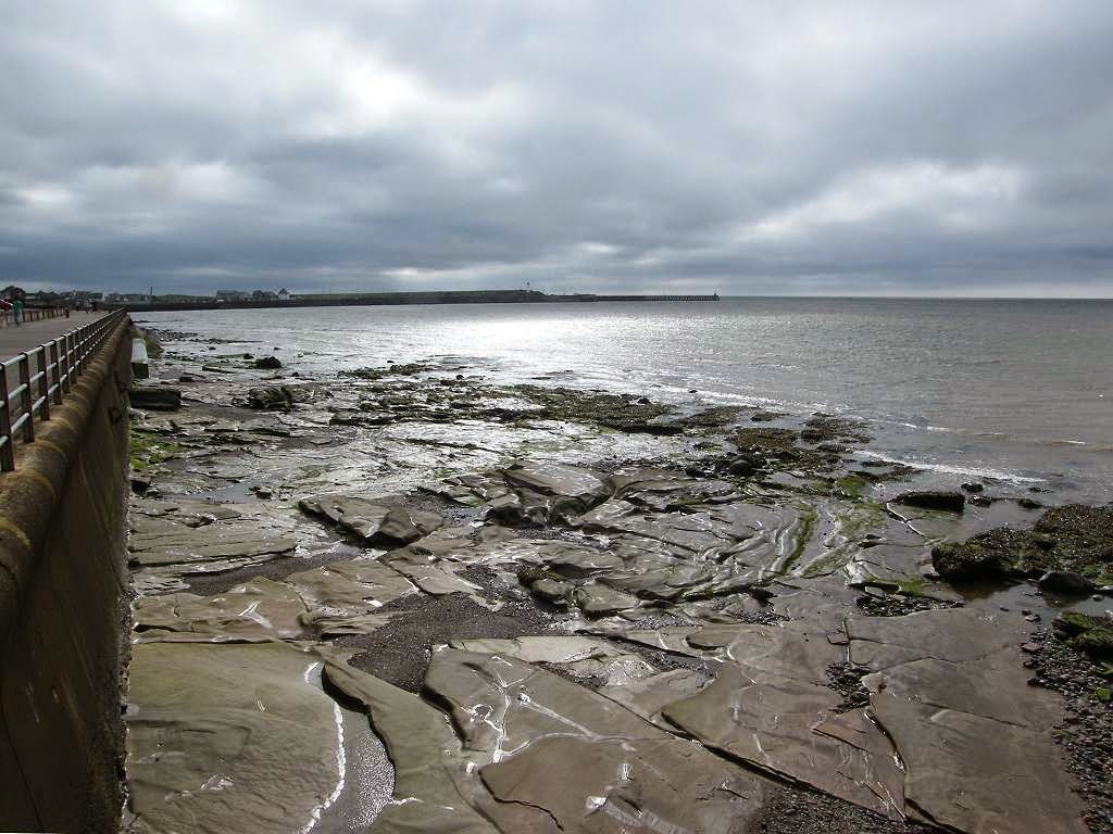
 We could have walked on the beach, but it was a bit
rocky and would have taken us longer. Further
on the rocks looked smooth and slippery, so we were glad we weren’t down
there. They had a kind of ‘sculptured’
look, caused by the action of the waves.
Lovely swirls, it looked quite artistic!
Eventually we came to a golf course.
The path led along the edge of the greens, but there was nobody playing.
We could have walked on the beach, but it was a bit
rocky and would have taken us longer. Further
on the rocks looked smooth and slippery, so we were glad we weren’t down
there. They had a kind of ‘sculptured’
look, caused by the action of the waves.
Lovely swirls, it looked quite artistic!
Eventually we came to a golf course.
The path led along the edge of the greens, but there was nobody playing.
 We came to a concrete prom, and there must have been
car parks nearby because suddenly we met lots of people again. We sat on a bench to eat our apples. The wind had turned cold by then, and the sky
slate-grey. Hang on! It’s only the third of
September! We carried on towards
Maryport. Sometimes we had a bit of a
beach, and sometimes the water was right up to the prom.
We came to a concrete prom, and there must have been
car parks nearby because suddenly we met lots of people again. We sat on a bench to eat our apples. The wind had turned cold by then, and the sky
slate-grey. Hang on! It’s only the third of
September! We carried on towards
Maryport. Sometimes we had a bit of a
beach, and sometimes the water was right up to the prom.

 We passed interestingly shaped driftwood,
families rock-pooling and watched the antics of several different kinds of
birds. All the sights and sounds of the
seaside, but it shouldn’t have been so
cold! It’s still Summer, for goodness
sake!
We passed interestingly shaped driftwood,
families rock-pooling and watched the antics of several different kinds of
birds. All the sights and sounds of the
seaside, but it shouldn’t have been so
cold! It’s still Summer, for goodness
sake!

 The first beach we came to in
Maryport was strewn with litter — an ugly mess caused by people throwing their
rubbish off ships and boats into the sea.
The first beach we came to in
Maryport was strewn with litter — an ugly mess caused by people throwing their
rubbish off ships and boats into the sea.
We reached Maryport Harbour, and started to walk out on the northern pier. But it was so windy and cold we turned back before we had got halfway.
 We carried on past a row of
terraced houses. Between them and the
sea was a piece of waste land, and the words “ NO FLATS ” were written on a wall there. If a block of flats was built on the waste
land, the people in the terraced houses would completely lose their view.
We carried on past a row of
terraced houses. Between them and the
sea was a piece of waste land, and the words “ NO FLATS ” were written on a wall there. If a block of flats was built on the waste
land, the people in the terraced houses would completely lose their view.
 We reached the head of the harbour.
We saw the Maritime
Museum across the road,
but then Colin spotted his CAMRA pub that he had been looking out for — The
Lifeboat Inn. So we popped in there for
a quick ‘arf and a warm.
We reached the head of the harbour.
We saw the Maritime
Museum across the road,
but then Colin spotted his CAMRA pub that he had been looking out for — The
Lifeboat Inn. So we popped in there for
a quick ‘arf and a warm.

 When we came out, we crossed into the dock area over the Ellenfoot Bridge, a Dutch-type lifting bridge
which was built in 2007. There was a
rather nice fishermen’s statue there, but some sub-teenage children had climbed
on to it and were being silly, so I didn’t photograph it. Thank
goodness they will all be back in school tomorrow! It was really quite cold now, not like summer
at all. Maryport Harbour
has been revamped and turned into a fancy marina. Whether that is a good thing for the town or
not is a moot point — marinas don’t exactly bring in much employment for the
townsfolk.
When we came out, we crossed into the dock area over the Ellenfoot Bridge, a Dutch-type lifting bridge
which was built in 2007. There was a
rather nice fishermen’s statue there, but some sub-teenage children had climbed
on to it and were being silly, so I didn’t photograph it. Thank
goodness they will all be back in school tomorrow! It was really quite cold now, not like summer
at all. Maryport Harbour
has been revamped and turned into a fancy marina. Whether that is a good thing for the town or
not is a moot point — marinas don’t exactly bring in much employment for the
townsfolk.
 We came across a memorial to the fishing vessel ‘Aquila’ which capsized
off Ardnamurchan, Scotland, in July 2009, drowning
all three fishermen who were on board – “Three sons of Maryport who never came home”. We take the fish on our plates so much for
granted — sea fishing is a very dangerous occupation.
We came across a memorial to the fishing vessel ‘Aquila’ which capsized
off Ardnamurchan, Scotland, in July 2009, drowning
all three fishermen who were on board – “Three sons of Maryport who never came home”. We take the fish on our plates so much for
granted — sea fishing is a very dangerous occupation.
 We were pleased that we were able to get across the lock gates. We walked round the end to the southern pier,
but we didn’t walk along the length of it because it was too windy and
cold. Besides, time was catching up with
us and we needed to get a move on. We
turned south.
We were pleased that we were able to get across the lock gates. We walked round the end to the southern pier,
but we didn’t walk along the length of it because it was too windy and
cold. Besides, time was catching up with
us and we needed to get a move on. We
turned south.
 As we left Maryport we climbed up to a higher path because that looked
the better bet. It was a good path at
first, but it deteriorated as we ploughed on south. It started going up and down a bit, and we
noticed that we had once again lost all the people! We caught our first glimpse of Workington
ahead in the mist. We could hardly see
it, and realised we still had a long way to go.
As we left Maryport we climbed up to a higher path because that looked
the better bet. It was a good path at
first, but it deteriorated as we ploughed on south. It started going up and down a bit, and we
noticed that we had once again lost all the people! We caught our first glimpse of Workington
ahead in the mist. We could hardly see
it, and realised we still had a long way to go.
When we thought we were at Flimby, we sat on a sheltered seat (behind a purpose-built wall, so they must know how windy it gets here) and ate our chocolate. We were disappointed when we found out later that we were nowhere near Flimby, in fact we were hardly out of Maryport! The path got very bad, it was almost impossible at times. We don’t think many people walk this way.
When, at last, we reached Flimby Station, we seriously considered crossing over to the road because the going on the official coastal path was so difficult. But we both hate roads, so we didn’t. Come on! We have walked far worse paths in Scotland! We were determined not to let the overgrown, uneven, and often invisible, path beat us! Some hooded youths were mucking about on the station platform being loud and silly. When we heard the sound of breaking wood, we thought we’d just best carry on as they hadn’t seen us. Already we were losing daylight.
We had to cross occasional streams, and at each one there was a little wooden footbridge for us to use, one of which was new. So we knew we were on the official path, but it was horrible to walk. Maintenance seems to have gone by the board. We passed lots of modern windmills, huge constructions all doing their stuff with a mild whirring noise. I would hate to live near them because the noise would drive me bananas — it is so irritating — and they are always sited in a windy place, obviously. I hate the wind! We are so fortunate in where we live now on the eastern side of the Malvern Hills. We are very sheltered, we hardly ever have a windy day at home.
 We passed a sewage works — it was smelly!
The path took us on to the beach to pass a tall concrete wall, then up
some metal steps so that we were on top of it.
According to our map, the path should have divided here, one branch
following the high water line on the beach — but we never saw the
division. Besides, we were anxious to
get into Workington before it got really dark.
We passed a sewage works — it was smelly!
The path took us on to the beach to pass a tall concrete wall, then up
some metal steps so that we were on top of it.
According to our map, the path should have divided here, one branch
following the high water line on the beach — but we never saw the
division. Besides, we were anxious to
get into Workington before it got really dark.
When we climbed to the top of the wall we found, with relief, that we were on a good path. We were losing light rapidly, and it was difficult to see the detail in the twilight gloom. This path turned into a pot-holed road, but we were able to ‘slalom’ round the water-filled hollows. We couldn’t think why this road had been built in the first place, it didn’t lead anywhere, and it was impossible to get a vehicle on to it at either end.
Location: Mawbray, via Maryport, to Workington.
Distance: 15 miles.
Total distance: 3128 miles.
Terrain: Mostly grassy dune paths, some clear and open, some overgrown. Concrete in towns. Mostly flat.
Tide: In this morning, going out this afternoon.
Rivers: No.377, River Ellen at Maryport. No378, River Derwent at Workington.
Ferries: None.
Piers: None.
Kissing gates: No.372 near the start. No.373 near Maryport.
Pubs: The Lifeboat Inn in Maryport where we both drank Cumbrian Legendary ‘Langdale’.
‘English Heritage’ properties: None.
Ferris wheels: None.
Diversions: No.65. The map was inaccurate — the footway on the railway bridge didn’t exist. (Someone told us later that it had been washed away a couple of years ago.)
How we got there and back: We were staying in our caravan in St Bees. This morning we drove to Workington and with some difficulty found the car park out on a headland. We walked over a mile to the railway station, and still having time in hand we walked on to the bus station. We caught one of the frequent buses to Maryport. Then we discovered that the timetable for our next bus had been changed back in July, but they hadn’t told ‘Traveline’ from whose website I checked the bus times only last week. We had just missed one, and had to wait an hour and a half for the next. We were furious! We had a long Walk ahead of us, and couldn’t afford to be delayed that long. But we just had to stick it out — there was no other way to get to Mawbray.
At the end we finished the Walk at Workington Railway Station. It was already dark — how we wished we had parked by the river near the station! This evening we couldn’t work out why we hadn’t. There is so much to think about when planning these Walks, common sense sometimes goes by the board! We had to walk over a mile by the river to our car parked on the headland. From there we drove straight back to our caravan in St Bees.
We were really annoyed that the website ‘Traveline’ had let us down once again. The timetable had changed last July, apparently, but it wasn’t on the website when I rechecked all our bus times only a few days ago. As a result, we couldn’t start the Walk until nearly midday, and finished it in the dark. We ate our pies whilst waiting for the bus, there wasn’t much else to do.
We reached Allonbury, and found we could walk on a greensward which was very pleasant. There were lots of families about, making the most of the last day of the school holidays — yes, most schools in the country reopen for the 2012/2013 year tomorrow. I can hardly believe the time has passed so quickly, and that two of our little grandchildren start school for the first time tomorrow! It only seems five minutes since they were born! Natalie is starting at her village school in Moulton, Suffolk, and Franklyn is starting at his local school, Rosendale in Dulwich, London.
Back to the Walk — the toilet block in Allonbury was decorated with a lovely mural depicting a carefree seaside scene. I do so love this kind of mural, it really brightens up the place. We sat on a bench to eat our sarnies while we watched families happily at play.

We reached Maryport Harbour, and started to walk out on the northern pier. But it was so windy and cold we turned back before we had got halfway.
When we thought we were at Flimby, we sat on a sheltered seat (behind a purpose-built wall, so they must know how windy it gets here) and ate our chocolate. We were disappointed when we found out later that we were nowhere near Flimby, in fact we were hardly out of Maryport! The path got very bad, it was almost impossible at times. We don’t think many people walk this way.
When, at last, we reached Flimby Station, we seriously considered crossing over to the road because the going on the official coastal path was so difficult. But we both hate roads, so we didn’t. Come on! We have walked far worse paths in Scotland! We were determined not to let the overgrown, uneven, and often invisible, path beat us! Some hooded youths were mucking about on the station platform being loud and silly. When we heard the sound of breaking wood, we thought we’d just best carry on as they hadn’t seen us. Already we were losing daylight.
We had to cross occasional streams, and at each one there was a little wooden footbridge for us to use, one of which was new. So we knew we were on the official path, but it was horrible to walk. Maintenance seems to have gone by the board. We passed lots of modern windmills, huge constructions all doing their stuff with a mild whirring noise. I would hate to live near them because the noise would drive me bananas — it is so irritating — and they are always sited in a windy place, obviously. I hate the wind! We are so fortunate in where we live now on the eastern side of the Malvern Hills. We are very sheltered, we hardly ever have a windy day at home.
When we climbed to the top of the wall we found, with relief, that we were on a good path. We were losing light rapidly, and it was difficult to see the detail in the twilight gloom. This path turned into a pot-holed road, but we were able to ‘slalom’ round the water-filled hollows. We couldn’t think why this road had been built in the first place, it didn’t lead anywhere, and it was impossible to get a vehicle on to it at either end.
The road seemed to go on forever, far longer than we had
anticipated. Perhaps we were just tired. We must have been walking along it for over
an hour. The wind was cold and the sky
got very grey. I think the overcast sky
had more to do with the loss of light than the sun going down, and we had no
idea when the sun actually set because we hadn’t seen it since this
morning. It started to rain at one
point, so we struggled into our kags — and it immediately stopped! We kept the kags on for warmth.
We could hear church bells in the distance, a sound which got louder as
we approached Workington. We thought it
must be bell-ringing practice night, and found the sound soothing. Church bells in an evening always remind me
of my happy childhood holidays at my grandfather’s home in Arundel, Sussex. I find them quite nostalgic.
Eventually we reached a proper road with a bridge across the railway. We crossed straight over the road and
continued on the cycle path next to the river because our new and expensive OS
map (yes! we’re there again!) showed
the cycle path crossing the river alongside the railway. But it didn’t, and showed no sign of it ever
having done so! Frustrated and angry, we
looked at the map again and noted that there was a footbridge across the river
further downstream. But that wasn’t there either!
We found out, at a later date, that this particular bridge had been
washed away in a storm a couple of years ago.
There were no signs that it was going to be replaced, so we concluded
that it isn’t. I wonder how many
years/decades/centuries it will take the Ordnance Survey to catch up with this
fact!
We had wasted about half an hour over this, and had to return to the road
bridge over the railway.
 There was a
mishmash of railway lines leading into the docks, and Colin photographed a
‘puffing-billy’ warning sign — it was amazing it came out so clearly in the
half-dark. We had to go inland and loop
a long way round to cross the river on a road bridge.
There was a
mishmash of railway lines leading into the docks, and Colin photographed a
‘puffing-billy’ warning sign — it was amazing it came out so clearly in the
half-dark. We had to go inland and loop
a long way round to cross the river on a road bridge.
There was a brand new road bridge, not open yet, which would have saved us a bit of distance, but we couldn’t get near it. (You’ve guessed it! No sign of it on the OS maps yet, not even as a dotted line!) It’s no wonder we got confused at the Tesco roundabout, but we managed to leave it on the correct road. The only saving grace was the church bells which were still ringing — they were quite loud now. We stopped in the square under a lamppost to discuss the map, and a man standing by a lorry came over and asked where we were sleeping tonight. When we said, “St Bees” he was quite concerned because he thought we were going to carry on walking to there in the dark! We reassured him that our car was parked in Workington, but in actual fact it was parked a mile out of the town on a headland — bit of bad planning there!
We came to the railway station.
That ended Walk no.307, we shall pick up Walk no.308 next time at Workington Railway Station. It was ten past eight, so the Walk had taken us eight and a half hours. It was already dark — how we wished we had parked by the river near the station! This evening we couldn’t work out why we hadn’t. There is so much to think about when planning these Walks, common sense sometimes goes by the board! Colin offered to go and fetch the car while I sat on a bench by the river. But it was dark and cold — and I felt we were in a slightly dodgy part of town, not the sort of place to hang about in the gloom. So we both walked over a mile by the river to our car parked on the headland. From there we drove straight back to our caravan in St Bees.

No comments:
Post a Comment