Ages: Colin was 65 years and 363 days. Rosemary was 63 years and 140 days.
Weather: Warm and sunny most of the day, but a cool wind in exposed places. Later a cold sea mist enveloped us — it became cold and clammy with a weird light. We couldn’t see far, and our hair got wet!
Location: Newburgh to Cruden Bay.
Distance: 14½ miles.
Total distance: 1521½ miles.
Terrain: Roads, tracks, grassy paths, dodgy paths, steps, moorland, beaches, dunes – everything! Undulating as well.
Tide: In, going out. Right out at the end because we took so long.
Rivers: No.122, Foveran Burn at Newburgh. No.123, the River Ythan at Newburgh. No.124, Water of Cruden at Cruden Bay.
Ferries: None.
Piers: None.
Kissing gates: No.150 where we exited a nature reserve near Collieston.
Pubs: None.
‘Historic Scotland’ properties: No.13, Tolquhon Castle. This is situated several miles inland so we didn’t have to visit it, but we did on a different day because it was interesting.
Ferris wheels: None.
Diversions: None.
How we got there and back: We were staying in a cottage in Pennan. This morning we drove to Cruden Bay and parked for free near some public toilets which were open both morning and evening even though we got back late — well done Cruden Bay! We walked a few yards up the road to a bus stop where we caught a bus to Newburgh. There we walked down to the golf course, to the exact spot where we had parked the car yesterday.
At the end, we turned left after crossing the footbridge and walked up the road to our car. After tea and biscuits we drove our misty way back towards Pennan. As we topped the last hill before descending into the village, the mist cleared revealing the setting sun — it was beautiful, as if someone had just switched on the lights!

 We visited Tolquhon Castle on one of our ‘rest’ days.
  It is situated several miles inland from Newburgh, beyond Ellon. It is a bit out in the sticks, and we were the only visitors that morning.
It is not really a castle, more of a fortified manor house built in the late middle ages. We didn’t think it was ever seriously a castle.

 Still, it was fun to look around — climbing and descending the spiral staircases, looking out of tower windows and investigating the kitchens with their huge ovens. When we’d had enough, we sat at a picnic table on the lawn to have our lunch before going on elsewhere.


 We started the Walk in the car park of Newburgh Golf Club, where we had finished the Walk yesterday. We followed the lane for a couple of hundred yards, then turned off to walk between the golf course and Foveran Burn. It was a beautiful day, and we had fine views across the burn to the village. A number of ducks and swans made the picture — it was idyllic! One pair of ducks were proudly showing off no less than thirteen fluffy chicks.
 The ‘Nor-trail’ signs tried to take us across the first footbridge, but we went across the second one because it was nearer the mouth of the burn which came out in the River Ythan a little further up.
  The path then took us in front of a row of houses to a workshop at the end, back along the river bank, then through what seemed to be someone’s garden to the road. Further along the road there are new-builds on the old quay. Just before the road bridge across the River Ythan we came across a bench, so we sat on it to eat our pasties and look at the view.
We crossed the river on the road bridge, and almost immediately turned into a nature reserve. We looked at a map displayed there and worked out the ‘blue’ circular walk was the ‘nearest safe path to the sea’ if we were to follow it half way round until it got us to the beach. So we turned south, which was a bit annoying as we were two miles north of the mouth of the River Ythan by then. My calf muscle was giving me a lot of grief, I don’t know why it had become so painful. So I rubbed ‘Powergel’ into it and that seemed to do the trick. I still carry a tube of ‘Powergel’ with me when I walk, even though my arthritic toe has not given me any trouble for about two years now. Long may it last!
 We
We  followed a track which turned into a footpath by the river. Round a bend in the river we came across the largest colony of breeding eider ducks in the country — so the nature reserve blurb told us. I love the noise they make, like a crowd of gossiping women! Then we came to the ternery which was completely barred off and out of bounds. This is because the terns are in a bad way. The little tern, in particular — a mere twenty pairs managed to fledge just one chick last year, none the year before! We
  were pleased we had an excuse for not walking all the way back to the mouth of the river, and could take a short-cut across the dunes. We were disappointed that we couldn’t go anywhere near the sandbank where the seals were hauled out yesterday. We were sad for the fate of the little tern, and all the other sorts of terns which aren’t faring much better.
We cut across the dunes and it was like a desert! The fact that it was a hot sunny day added to the illusion. The dry sand was piled high and quite difficult to walk on. We slithered down the dunes to the beach where we turned north. The tide was beginning to go out, so we had some wet sand to walk on which was firmer. We began to meet people because we were on a fine beach, the weather was warm and it was May Day bank holiday Monday. We walked the length of the beach, and crossed a stream
  where children were playing.
The sands came to an end, so we climbed up the bank and passed Forvie church. This is a simple rectangular building constructed in the 12th century, but there is very little of it left. It seemed to be full of water. Apparently it is the last remnant of Forvie village which was swallowed up by a sandstorm in the 14th or 15th century. It was discovered in the 1950s, and dug out along with various artefacts.
I didn’t think to photograph it until we were well past, and I wasn’t willing to go back. I was distracted because a blister was forming on my left heel and becoming increasingly uncomfortable. I couldn’t understand it. My boots, the fourth pair since we started this Trek nearly ten years ago, are well worn in — I have done over 500 miles in them. They have always been extremely comfortable, so why start causing a blister now?
It was moorland on top of the cliff, with lots of wild flowers and butterflies. It was a trifle muddy in places, but we found some deep heather which was bone dry and made a lovely cushion to sit on. So we rested and ate our sarnies — with spectacular views of the sea and rocks covered with birds. Glorious!


 There were lots of people about walking the clifftop paths. Unusually we were not on our own. This was because it was a lovely day, and a bank holiday. We passed several bays with beautiful little beaches, and in between there were cliffs and rock stacks. It was a bit like Devon. Further on we met a man with an American accent who asked us if there was a ‘park bench’ anywhere about because he and his family wanted
  to sit and eat their lunch. We told him we hadn’t seen one, but we had sat on the heather to eat ours and it was very comfortable — we could recommend it. His face was a picture!
We left the nature reserve through a gate and descended into Collieston. I was feeling jaded and fancied an ice cream. But nowhere in this pretty little seaside village was there a shop or a café! There were crowds of people on the sandy beach, there were public toilets which were clean, open and free — for which we were very grateful. But no enterprise to sell ice creams, drinks or knickknacks to tourists. What an opportunity missed! So I had to make do with the water in my bottle.
Children were playing in the water, daring each other to go in deeper to reach some steps up to the quay. Further along, a group of teenagers were showing off by jumping into the harbour where it is deep. (We subsequently discovered that this is common practice in the Summer all round North-East Scotland, and we are surprised that there are not more serious injuries and fatalities attributed to this very dangerous pastime.) There was also a notice about making contributions to the
  pier fund, but it looked as if someone had nicked the box! We couldn’t find our way round to the next bay (we really were not concentrating) and ended up going the long way round by road. Then we came across the other end of the path we should have taken, and were very annoyed with ourselves. It was signposted at that end. We found a set of stocks round there, on the clifftop! We climbed St Catharine’s Dub and
  sat down — on a rock as there was no ‘park bench’! — to eat our apples and the rest of our sandwiches.
I felt very lethargic. My corns were hurting like hell and my blister was becoming very sore, though the troublesome calf muscle seemed to be OK. (Magic stuff, that Powergel!) I really didn’t want to go on, but I had no choice. We were less than halfway to Cruden Bay where our car was parked. I was annoyed with myself because it really was a fabulous Walk — scenery, wildlife, variety, balmy weather — we couldn’t have asked for more. So I pulled myself together and we got on with it.
The path onwards was not very obvious, but the blobs were there on our card maps so we looked until we found it. We climbed up extremely dodgy rocks (Colin had to help me all the way) to steps, and thence to the top of the cliffs. The path was very narrow, tilted sideways and was uncomfortable to walk, none of which did my corns or my blister any good. But the scenery, flowers, rocks and birds were amazing! We were on our own for the rest of the Walk — good views but uncomfortable walking.
Looking inland, we noticed a pond which had an eerie white mist rising above it. It was most strange. Looking ahead towards the castle marked on our map, we hardly noticed that visibility was not all that it should be.
We reached Slains Castle (rems of) after a far-from-easy walk. The ruins weren’t much, we didn’t even bother to go over to them. There was a family on the beach far below, packing up for the day. We began to feel a slight chill in the air. We sat on a bank overlooking the castle and the beach for a rest and another snack. Our blobs ended at that point on our card maps, there was no coast path for the next four miles. So we went on tracks past a farm out to a road. It was a minor lane with hardly any traffic, but even so we hate roads! So we both went into route-march mode — DEADLY! As we passed a buzzing oil pipeline booster station, we noticed a sea mist
  creeping over the fields. As it reached us the air turned cold, clammy, much darker and visibility was only a few feet. Spooky! We stopped at Whinnyfold (where someone had conveniently placed two ‘park benches’ in the lee of a wall, supposedly to look at the view which had disappeared) to eat our chocolate. We also donned coats, hats and gloves — yes, it was that cold! We were fast disappearing into a thick fog.
The blobs started up there again on our card maps, leading round several headlands on the clifftop before descending to the southern end of Cruden Bay. Our problem was we could hardly see our feet — it was not the sort of weather to be walking on a clifftop! It would have been more prudent to have gone round by road, but that was miles out of our way so we didn’t even consider it. Colin led and I followed, taking each step very carefully indeed. The path was narrow, tilted sideways and was uncomfortable to walk. We could just about see the cliff edge, but certainly couldn’t see the rocks or sea below. My blister began to hurt big-time, probably because I was concentrating so hard. My whole body was tense.
 It seemed to take ages. Every time we came to a headland I would think, “Surely now it is the path down to the beach!” But it wasn’t. After an eternity, suddenly it was! Not a bad path as cliff paths go, and as we descended at last we could just make out the bottom. We were on the beach — relief!
 The
The  fog didn’t seem to be quite so thick down there, but we still couldn’t see the sea as the tide was out by then. We could hear it and knew it was close — quite eerie. It was rocky at first with pink granite boulders, but not for long. Soon we were on firm sand, and knew this stretched for one and a half miles to the end of the Walk.
We were alone in our murky world. We both felt a lot brighter, I think it was relief that the difficult parts of the Walk were over. We trudged along hand in hand, listening to the waves out there somewhere in the mist. We came across a couple of streams running over the sand, but they were no problem because they were so shallow. The tide was right out by then. We actually rather enjoyed this part of the Walk despite the conditions.
 AT LAST we began to meet a sparsity of dog-walkers appearing out of the gloom. I asked the first ones if they were ghosts as they seemed suddenly to be upon us, materialising out of the fog. They answered, yes they were! We came upon Cruden Bay village suddenly, or so it seemed as we hadn’t been able to see it from a distance. There had been nothing for so long, and then it was there. We saw the buildings first, and then realised we were almost standing in the river. The mist was thicker than ever, and our hair was quite wet. We walked upstream until we found the footbridge, and crossed.

That ended Walk no.177, we shall pick up Walk no.178 next time by the footbridge in Cruden Bay village. It was ten to eight, so the Walk had taken us nine hours. We had our tea and biscuits, and were pleased that the toilets (clean, open and free!) were still open with a light on. Well done Cruden Bay! That sort of thing makes our journeys so much more comfortable! Then we drove our misty way back towards Pennan. It was foggy all the way until we topped the last hill. As we descended into the village, the mist cleared revealing the setting sun — it was beautiful, as if someone had just switched on the lights!
Weather: Warm and sunny most of the day, but a cool wind in exposed places. Later a cold sea mist enveloped us — it became cold and clammy with a weird light. We couldn’t see far, and our hair got wet!
Location: Newburgh to Cruden Bay.
Distance: 14½ miles.
Total distance: 1521½ miles.
Terrain: Roads, tracks, grassy paths, dodgy paths, steps, moorland, beaches, dunes – everything! Undulating as well.
Tide: In, going out. Right out at the end because we took so long.
Rivers: No.122, Foveran Burn at Newburgh. No.123, the River Ythan at Newburgh. No.124, Water of Cruden at Cruden Bay.
Ferries: None.
Piers: None.
Kissing gates: No.150 where we exited a nature reserve near Collieston.
Pubs: None.
‘Historic Scotland’ properties: No.13, Tolquhon Castle. This is situated several miles inland so we didn’t have to visit it, but we did on a different day because it was interesting.
Ferris wheels: None.
Diversions: None.
How we got there and back: We were staying in a cottage in Pennan. This morning we drove to Cruden Bay and parked for free near some public toilets which were open both morning and evening even though we got back late — well done Cruden Bay! We walked a few yards up the road to a bus stop where we caught a bus to Newburgh. There we walked down to the golf course, to the exact spot where we had parked the car yesterday.
At the end, we turned left after crossing the footbridge and walked up the road to our car. After tea and biscuits we drove our misty way back towards Pennan. As we topped the last hill before descending into the village, the mist cleared revealing the setting sun — it was beautiful, as if someone had just switched on the lights!
Tolquhon Castle

 We visited Tolquhon Castle on one of our ‘rest’ days.
  It is situated several miles inland from Newburgh, beyond Ellon. It is a bit out in the sticks, and we were the only visitors that morning.
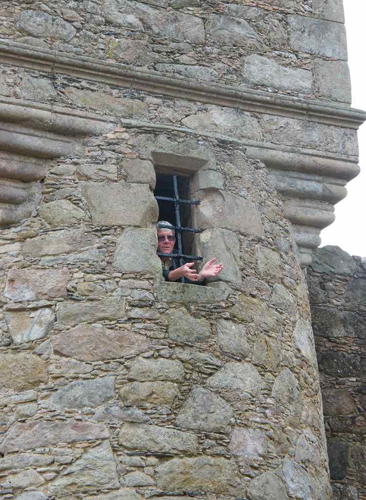
 Still, it was fun to look around — climbing and descending the spiral staircases, looking out of tower windows and investigating the kitchens with their huge ovens. When we’d had enough, we sat at a picnic table on the lawn to have our lunch before going on elsewhere.

 We started the Walk in the car park of Newburgh Golf Club, where we had finished the Walk yesterday. We followed the lane for a couple of hundred yards, then turned off to walk between the golf course and Foveran Burn. It was a beautiful day, and we had fine views across the burn to the village. A number of ducks and swans made the picture — it was idyllic! One pair of ducks were proudly showing off no less than thirteen fluffy chicks.
 The ‘Nor-trail’ signs tried to take us across the first footbridge, but we went across the second one because it was nearer the mouth of the burn which came out in the River Ythan a little further up.
  The path then took us in front of a row of houses to a workshop at the end, back along the river bank, then through what seemed to be someone’s garden to the road. Further along the road there are new-builds on the old quay. Just before the road bridge across the River Ythan we came across a bench, so we sat on it to eat our pasties and look at the view.
We crossed the river on the road bridge, and almost immediately turned into a nature reserve. We looked at a map displayed there and worked out the ‘blue’ circular walk was the ‘nearest safe path to the sea’ if we were to follow it half way round until it got us to the beach. So we turned south, which was a bit annoying as we were two miles north of the mouth of the River Ythan by then. My calf muscle was giving me a lot of grief, I don’t know why it had become so painful. So I rubbed ‘Powergel’ into it and that seemed to do the trick. I still carry a tube of ‘Powergel’ with me when I walk, even though my arthritic toe has not given me any trouble for about two years now. Long may it last!
 We
We  followed a track which turned into a footpath by the river. Round a bend in the river we came across the largest colony of breeding eider ducks in the country — so the nature reserve blurb told us. I love the noise they make, like a crowd of gossiping women! Then we came to the ternery which was completely barred off and out of bounds. This is because the terns are in a bad way. The little tern, in particular — a mere twenty pairs managed to fledge just one chick last year, none the year before! We
  were pleased we had an excuse for not walking all the way back to the mouth of the river, and could take a short-cut across the dunes. We were disappointed that we couldn’t go anywhere near the sandbank where the seals were hauled out yesterday. We were sad for the fate of the little tern, and all the other sorts of terns which aren’t faring much better.
We cut across the dunes and it was like a desert! The fact that it
 was a hot sunny day added to the illusion. The dry sand was piled high and quite difficult to walk on. We slithered down the dunes to the beach where we turned north. The tide was beginning to go out, so we had some wet sand to walk on which was firmer. We began to meet people because we were on a fine beach, the weather was warm and it was May Day bank holiday Monday. We walked the length of the beach, and crossed a stream
  where children were playing.
The sands came to an end, so we climbed up the bank and passed Forvie church. This is a simple rectangular building constructed in the 12th century, but there is very little of it left. It seemed to be full of water. Apparently it is the last remnant of Forvie village which was swallowed up by a sandstorm in the 14th or 15th century. It was discovered in the
 1950s, and dug out along with various artefacts.
I didn’t think to photograph it until we were well past, and I wasn’t willing to go back. I was distracted because a blister was forming on my left heel and becoming increasingly uncomfortable. I couldn’t understand it. My boots, the fourth pair since we started this Trek nearly ten years ago, are well worn in — I have done over 500
 miles in them. They have always been extremely comfortable, so why start causing a blister now?
It was moorland on top of the cliff, with lots of wild flowers and butterflies.
 It was a trifle muddy in places, but we found some deep heather which was bone dry and made a lovely cushion to sit on. So we rested and ate our sarnies — with spectacular views of the sea and rocks covered with birds. Glorious!

 There were lots of people about walking the clifftop paths. Unusually we were not on our own. This was because it was a lovely day, and a bank holiday. We passed several bays with beautiful little beaches, and in between there were cliffs and rock stacks. It was a bit like Devon. Further on we met a man with an American accent who asked us if there was a ‘park bench’ anywhere about because he and his family wanted
  to sit and eat their lunch. We told him we hadn’t seen one, but we had sat on the heather to eat ours and it was very comfortable — we could recommend it. His face was a picture!
We left the nature reserve through a gate and descended into Collieston. I was feeling jaded and fancied an ice cream. But nowhere in this pretty little seaside village was there a shop or a café! There
 were crowds of people on the sandy beach, there were public toilets which were clean, open and free — for which we were very grateful. But no enterprise to sell ice creams, drinks or knickknacks to tourists. What an opportunity missed! So I had to make do with the water in my bottle.
Children were playing in the water, daring each other to go in deeper to reach some steps up to
 the quay. Further along, a group of teenagers were showing off by jumping into the harbour where it is deep. (We subsequently discovered that this is common practice in the Summer all round North-East Scotland, and we are surprised that there are not more serious injuries and fatalities attributed to this very dangerous pastime.) There was also a notice about making contributions to the
  pier fund, but it looked as if someone had nicked the box! We couldn’t find our way round to the next bay (we really were not concentrating) and ended up going the long way round by road. Then we came across the other end of the path we should have taken, and were very annoyed with ourselves. It was signposted at that end. We found a set of stocks round there, on the clifftop! We climbed St Catharine’s Dub and
  sat down — on a rock as there was no ‘park bench’! — to eat our apples and the rest of our sandwiches.
I felt very lethargic. My corns were hurting like hell and my blister was becoming very sore, though the troublesome calf muscle seemed to be OK. (Magic stuff, that Powergel!) I really didn’t want to go on, but I had no choice. We were less than halfway to Cruden
 Bay where our car was parked. I was annoyed with myself because it really was a fabulous Walk — scenery, wildlife, variety, balmy weather — we couldn’t have asked for more. So I pulled myself together and we got on with it.
The path onwards was not very obvious, but the blobs were there on our card maps so we looked until we found it. We climbed up extremely dodgy rocks (Colin had to help me all the way) to steps,
 and thence to the top of the cliffs. The path was very narrow, tilted sideways and was uncomfortable to walk, none of which did my corns or my blister any good. But the scenery, flowers, rocks and birds were amazing! We were on our own for the rest of the Walk — good views but uncomfortable walking.
Looking inland, we noticed a pond which had an eerie white mist rising above it. It was most
 strange. Looking ahead towards the castle marked on our map, we hardly noticed that visibility was not all that it should be.
We reached Slains Castle (rems of) after a far-from-easy walk. The ruins weren’t much, we didn’t even bother to go over to them. There was a family on the beach far below, packing up for the day. We began to feel a slight chill in the
 air. We sat on a bank overlooking the castle and the beach for a rest and another snack. Our blobs ended at that point on our card maps, there was no coast path for the next four miles. So we went on tracks past a farm out to a road. It was a minor lane with hardly any traffic, but even so we hate roads! So we both went into route-march mode — DEADLY! As we passed a buzzing oil pipeline booster station, we noticed a sea mist
  creeping over the fields. As it reached us the air turned cold, clammy, much darker and visibility was only a few feet. Spooky! We stopped at Whinnyfold (where someone had conveniently placed two ‘park benches’ in the lee of a wall, supposedly to look at the view which had disappeared) to eat our chocolate. We also donned coats, hats and gloves — yes, it was that cold! We were fast disappearing into a thick fog.
The blobs started up there again on our card maps, leading round several headlands on the clifftop before descending to the southern end of Cruden Bay. Our problem was we could hardly see our feet — it was not the sort of weather to be walking on a clifftop! It would have been more prudent to have gone round by road, but that was miles out of our way so we didn’t even consider it. Colin led and I followed, taking each step very carefully indeed. The path was narrow, tilted sideways and was uncomfortable to walk. We could just about see the cliff edge, but certainly couldn’t see the rocks or sea below. My blister began to hurt big-time, probably because I was concentrating so hard. My whole body was tense.
 It seemed to take ages. Every time we came to a headland I would think, “Surely now it is the path down to the beach!” But it wasn’t. After an eternity, suddenly it was! Not a bad path as cliff paths go, and as we descended at last we could just make out the bottom. We were on the beach — relief!
 The
The  fog didn’t seem to be quite so thick down there, but we still couldn’t see the sea as the tide was out by then. We could hear it and knew it was close — quite eerie. It was rocky at first with pink granite boulders, but not for long. Soon we were on firm sand, and knew this stretched for one and a half miles to the end of the Walk.
We were alone in our murky world. We both felt a lot brighter, I think it was relief that the difficult parts of the Walk were over. We trudged along hand in hand, listening to the waves out there somewhere in the mist. We came across a couple of streams running over the sand, but they were no problem because they were so shallow. The tide was right out by then. We actually rather enjoyed this part of the Walk despite the conditions.
 AT LAST we began to meet a sparsity of dog-walkers appearing out of the gloom. I asked the first ones if they were ghosts as they seemed suddenly to be upon us, materialising out of the fog. They answered, yes they were! We came upon Cruden Bay village suddenly, or so it seemed as we hadn’t been able to see it from a distance. There had been nothing for so long, and then it was there. We saw the buildings first, and then realised we were almost standing in the river. The mist was thicker than ever, and our hair was quite wet. We walked upstream until we found the footbridge, and crossed.
That ended Walk no.177, we shall pick up Walk no.178 next time by the footbridge in Cruden Bay village. It was ten to eight, so the Walk had taken us nine hours. We had our tea and biscuits, and were pleased that the toilets (clean, open and free!) were still open with a light on. Well done Cruden Bay! That sort of thing makes our journeys so much more comfortable! Then we drove our misty way back towards Pennan. It was foggy all the way until we topped the last hill. As we descended into the village, the mist cleared revealing the setting sun — it was beautiful, as if someone had just switched on the lights!

No comments:
Post a Comment