Ages: Colin was 77 years and 41 days. Rosemary was 74 years and 183
days.
Weather: Dull, grey and occasional spots of rain. (Disgusting
weather for June!)
Location: Milford Haven to Pembroke Dock.
Distance:
9 miles.
Total distance: 3940 miles.
Terrain: Some traffic-dodging roads. Some pavement-bashing. Some
grassy paths. Occasional see-through metal bridges! Undulating.
Tide: Out most of the day.
Rivers: No.454, Hubberston Pill. No.455, Castle Pill.
No.456, Westfield Pill. No.457, Daugleddau.
Ferries:
None.
Piers:
None.
Kissing
gates: Nos.944 & 945. (All the other gates were kissless!)
Pubs:
None.
‘Cadw’
properties: None.
Ferris
wheels: None.
Diversions:
None.
How we
got there and back: Two days ago we towed our caravan to Freshwater
East Caravan Site. (We were a day later than intended because,
just as we were about to leave home, the car battery decided to give
up the ghost. Then the door lock on the caravan pinged off in
several pieces on to the patio. By the time all that was fixed, it
was too late to travel to Pembrokeshire that day. So we came indoors
and opened a bottle of wine!) This morning we drove to Pembroke
Dock where we parked in a street near the station. From there we
caught a bus to Milford Haven Tesco, near where we had finished the
last Walk 21 months ago.
At the
end we came to the car which was parked near the station. We got in
and drove straight back to our caravan.
Nearly two years! We hadn't intended it to be so long, but we had a
bit of bad luck. Shortly after we returned home last time, Colin
drove the car through a ford which was deeper than he thought. Water
got into the engine, and the car was a right-off! We had
to buy another car because the bus service has been withdrawn from
our village and it is a two and a half mile walk to the nearest town.
We felt trapped in our own home.
BUT.....we were paying off a huge mortgage in lump sums, it was
nearing the end of the time allowed to pay it off and the mortgage
company were beginning to send mildly threatening letters. We hadn't
a penny to spare.
Fortunately our local garage had a little Ford Fiesta for sale quite
cheaply. A lovely little car which did for our immediate needs
BUT.....you cannot tow a caravan with a Ford Fiesta!
Eventually, by tightening our belts and staying at home, we paid off
the mortgage by the end of 2018. Relief! It had been a millstone
round our necks ever since we moved to Malvern in 2007. Now the
house of our dreams is fully ours, down to the last cobweb! And we
have all this surplus pension money coming in which we don't have to
immediately send off to the mortgage company!
For the first time in our lives we don't have to penny-pinch
— we can relax and afford things! By 1st May 2019 we
had bought a Vauxhall Insignia which tows our caravan beautifully.
At last we are back in Pembrokeshire, so let's get started!
We went into Milford Haven Tesco to buy our lunch, but we left
disappointed for two reasons. (a) They have closed their
delicatessen counter so we couldn't buy the lunch we wanted. (b)
They hadn't got a café
and we had fancied a hot chocolate before we started our Walk.
We
climbed up on to the “bridge” over the river, and it was only
then we realised we could have stayed below because of the
culverting. We could have saved ourselves a climb.
Our OS map for this area is about 30 years old and it directed us up
the main shopping street. But we were delighted to find that there
is now a footpath along the waterfront which is lined with little
shops and cafés because
this part of the river is now a marina. We dashed into the first
café we came to and ordered hot
chocolate to cheer ourselves up. We are so fed up with this rotten
weather, as is everyone else.
But this won't do, we have a
Walk to do! We
continued along the waterfront to where the shops gave way to
terraced houses. Several of them had gnomes on their tiny front
patios, and one was a witch's garden!
The waterfront came to an end
and we had to climb a steep hill inland. This came out in a
residential road where there was a bridge over a disused railway. We
tried the residential road first, but it was a dead end and we had to
retrace our steps. We wanted to get down on to the old railway which
is now a tarmacked path, but there was no way down that we could see.
(The complete lack of
any signage for walkers was disgraceful.)
So we continued steeply uphill until we came to a path leading off
in our direction. This remained high above the disused railway for
several hundred yards until, at last, there was a linking path down
to it. We were puzzled as to how we had missed the beginning of this
railway path back in Milford Haven.
Having met no one since we left
the shops/café area on the waterfront, here we met several
dog-walkers, some of whom stopped to chat. But the 'railway' soon
ended at an unfriendly locked gate with 'keep
out' notices all
over it. Beyond was an industrial area which looked mostly disused,
including a swing bridge across Castle Pill.
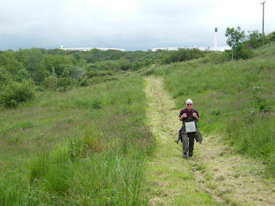
We followed a path leading uphill
to a house, and thought we would have to climb further up the hill on
a road. But then Colin spied a narrow path leading up behind the
house through bushes. Initially it was quite steep, but it soon
levelled out. It would have been a lovely path through trees with
views of yachts moored in Castle Pill, except for one thing — the
rubbish! There
was litter strewed everywhere, mostly plastic junk-food wrappers and
drinks cans. It was horrible!
We
passed a Celtic Cross which was disappearing into the undergrowth.
We came to a slipway, but the way on looked a bit slippery. We could
see the road bridge across Castle Pill (Black Bridge) but that was up
high and we were down low. We didn't know whether to follow the
soggy shoreline or to go uphill on a lane. There was no one about to
ask, and no
signage!
We decided, after much discussion, to follow the soggy shoreline
since the tide was out. We had to be very careful not to slip —
thank goodness I had my walking poles
It led us round the last
corner and gently up to the road. There we found the first
Wales Coast Path sign on this Walk! Up until this point we'd had to
use our initiative — good
job we know what that is!
Behind the sign was a seat that didn't look as it was used very
often.
We walked down the twisty hill to
the bridge. Part way down was a bunch of flowers wrapped in plastic
stuck in a tree, and lots of other plastic wrappers from previous
bunches of flowers which had been stuck there. It did look a mess —
why can't they take the plastic away and dispose of it?
We
crossed the bridge — now where? No signage, of course. I wished I
had looked at the map more closely using a magnifying glass, but my
eyesight is not that good on tiny detail and the green blobs on the
map said go up the road. So up the hill we trudged dodging traffic
on all the twisty bends for the road was quite busy. That part of
the Walk was horrid!
Again we were aghast at the amount of rubbish by the side of the
road — Costa
coffee cups, crisp bags, Coca Cola tins, takeaway cartons, lager
cans, etc
— we reckoned it had been chucked out of car windows. With relief
we reached the track leading to Venn Farm. I took off my high-viz
waistcoat — Colin hadn't been wearing his because he couldn't
remember where he had put it.
We bypassed the farm, crossed a
field and descended into a little wooded dell to cross a stream.
Colin found a log where we sat and enjoyed our lunch. Just as we
were commenting that we were on our own, we were passed by several
other walkers. Two ladies who stopped to chat told us that after
they had crossed Black Bridge a local lady told them of a different
way up the hill away from the road. We wished we had met that local
lady!
The
path was well defined from there all the way to Hazelbeach. We were
passing a lot of industrial constructions, all to do with the oil
terminal. But, like the path between St Ishmael's and Milford Haven,
it was a lot greener than we had anticipated. In fact, it was
generally a most enjoyable Walk.
We came to a metal tunnel which was
a bridge across a chasm. (We
were grateful for that, we didn't have to descend into the chasm and
climb out the other side!)
We
came to a metal bridge across numerous pipes which take in the oil
from the tankers at the jetties — but
there were no tankers there today.
It's a good job neither of us are bothered by heights — looking
straight down at the 'floor' of the bridge we could see a long way
down and it was like walking on nothing!
An Irish ferry passed as we
were doing this, reminding us that we once caught a ferry from
Pembroke Dock to explore Ireland, in 2000 I think it was. A third
bridge was high up over a private road which was inside the oil
terminal complex, and again this bridge had an 'invisible' floor.
We met several hikers going in
both directions. A couple of men stopped to chat for about ten
minutes. We were swapping our experiences of the Wales Coastal Path.
We stopped in a little dell where someone had previously lit a
campfire. There were logs to sit on, so we had a rest and a snack.
We had to climb out of there, but the way was through a lovely wood.
Eventually we came to Hazelbeach.
Hazelbeach is a lovely little
village. There were several pairs of swans on the mud, some had very
young cygnets alongside.
There were geese with goslings in the
stream, and the male goose had the colouring of a mallard duck!
We
walked along a lane in front of and between houses. We passed an old
church, and someone had a large rusty mangle, laundry size, outside
their house.
We came to a mainer road with
more traffic, but it had pavements. On the mud there were more swans
with cygnets. When the road turned inland away from the shore, we
left it to go into a large car park so that we could stay on the
waterfront.
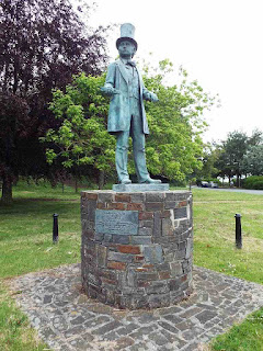
There we came across a statue of Isambard Kingdom
Brunel. We were both very weary by then and wished the Walk was
over. But it wasn't, we still had to cross the river. To do this we
had to get up on to not one, but two high bridges. We could see both
these bridges from the little park where we were standing, but how
could we get up there? According to our 30 year old OS map we walk
alongside the river for about a mile until we have gone under the
first high bridge. Then there is a way up the cliff to get us on to
the level of the bridge. We certainly hoped so — we were in no
mood to retrace our steps!
So, kags on, we marched through
gardens, a yacht basin with workshops and railway lines, past a pub
and onwards following a cycle path.
All the while we couldn't see
any sign of a way up the cliff to the level of the bridges. But sure
enough, about two hundred yards beyond the first bridge a little
yellow arrow on a post pointed to a narrow path up through the
bushes.
It wasn't too steep because it zigzagged and there were some
steps — and it got us up to the level of the bridges!
It was a bit hairy crossing the
road when we got to the top because there was no central island and
the traffic was coming thick and fast in both directions. But we
eventually found a gap and crossed quickly alongside a cyclist. The
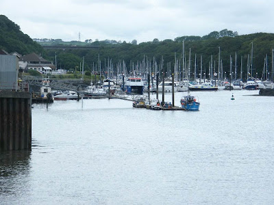
views from the first bridge were spectacular. There were a lot of
yachts moored in the river.
Then we had a long dull and noisy
(traffic noise) walk to the second bridge. This one was longer as it
crossed the main river and led into Pembroke Dock. It is half a mile
long and was opened in 1975. Before that there was a ferry if you
wanted to save a 28 mile detour. The views from this bridge were
more of an industrial nature.
There are now no tolls to cross this
bridge although we know there used to be — we have paid them in the
past. The toll booths were still there when we crossed, there were
notices on the approach saying “no tolls ahead” and there were
stop signs still painted on the road. All this made us think that
the tolls had only recently been stopped.
The first thing we passed after
crossing the bridge was a burnt out hotel! It was a one-storey
rambling building, and what was strange was that the fire seems to
have been in lots of different parts of the building. There seemed
to have been lots of little fires, not just one great big one. The
property was fenced off.
We came to a roundabout, and
noticed a lot of traffic was turning into an estate instead of using
the main road. We wondered if it was a 'rat-run', a short cut into
Pembroke Dock. If it went through it would mean we only had to walk
along one side of a triangle instead of two. We looked at our OS
map, but the area was marked as a mish-mash of industrial buildings
and was obviously completely out of date. We decided to take the
risk — and it paid off! We emerged at a roundabout
just down the road from the station, and we soon got to our car
parked in the street opposite.
That ended Walk
no.386, we shall pick up Walk no.387 next time near Pembroke Dock
railway station. It was quarter to seven, so the Walk had taken us
eight hours. We got in the car and drove straight back to our
caravan.


No comments:
Post a Comment