Ages: Colin was 71 years and 126 days. Rosemary was 68 years and 268 days.
Weather: Grey skies turning to persistent rain. Fog.
Not cold, but miserable.
Location: Holyhead to Trearddur Bay.
Distance: 11 miles.
Total distance: 3535miles.
Terrain: Good paths into and out of Holyhead. Concrete in the port. A mountain path round South Stack cliffs which was very undulating and foggy. (We lost the blue arrows we were following, and it was a bit scary!) Road-walking after that, which was quite undulating.
Tide: In.
Rivers: No.419, Holyhead Port.
Ferries: None.
Piers: None.
Kissing gates: Nos.603, 604, 605 and 606 all near the beginning of the Walk.
Pubs: None.
‘Cadw’ properties: None.
Ferris wheels: None.
Diversions: None.
How we got there and back: We were staying in our caravan on a remote farm in the middle of Anglesey. Today’s Walk was almost a circular and there were no convenient buses going the way we wanted them to. So we drove to Trearddur Bay and parked beyond the double yellow lines on the road to South Stack cliffs. Then we took a footpath across the island to Penrhos Beach — this was about two miles.
At the end we finished the Walk at the car. It was six o’clock, so the Walk had taken us 7 hours and 50 minutes. We had our tea and chocolate biscuits, then drove back to our caravan exhausted, soaking wet, fed up, and disappointed that our expensive waterproofs are no longer as waterproof as they used to be.
 At the top of Penrhos
Beach we came across a
redundant toilet block which was barred up and had waist-high weeds growing round
it. Colin wanted to find out if his
RADAR key would open the disabled loo which was not barred, and much to our
surprise we found it did! It looked
horrible and manky inside with no electricity or running water, but we didn’t
want to use it anyway having just used the pristine facilities at Morrison’s up
the road — we were just curious.
At the top of Penrhos
Beach we came across a
redundant toilet block which was barred up and had waist-high weeds growing round
it. Colin wanted to find out if his
RADAR key would open the disabled loo which was not barred, and much to our
surprise we found it did! It looked
horrible and manky inside with no electricity or running water, but we didn’t
want to use it anyway having just used the pristine facilities at Morrison’s up
the road — we were just curious.
 We hurriedly
locked it up again and took a grassy path round the edge of football fields
until we reached the remains of a ruined castle. There wasn’t much of this left. We continued round the edge of a field below
a row of Council houses, one of which was boarded up. We passed redundant factories and a
children’s nursery, then we were out on the road. All the while we were watching ferries going
in and out of Holyhead Harbour from and to Ireland.
We hurriedly
locked it up again and took a grassy path round the edge of football fields
until we reached the remains of a ruined castle. There wasn’t much of this left. We continued round the edge of a field below
a row of Council houses, one of which was boarded up. We passed redundant factories and a
children’s nursery, then we were out on the road. All the while we were watching ferries going
in and out of Holyhead Harbour from and to Ireland.
 There was a War Memorial up on the cliffs, but we didn’t go up
there. We turned left towards the
station, and passed through a rock cutting with interesting-looking geology. We passed an unusual building which was
boarded up, and guessed it may once have been a pub. Once a
spectacular building, it was now an eyesore — such a pity. We guessed it was ‘listed’ hence the owners
couldn’t demolish it.
There was a War Memorial up on the cliffs, but we didn’t go up
there. We turned left towards the
station, and passed through a rock cutting with interesting-looking geology. We passed an unusual building which was
boarded up, and guessed it may once have been a pub. Once a
spectacular building, it was now an eyesore — such a pity. We guessed it was ‘listed’ hence the owners
couldn’t demolish it.
 We turned into the port and crossed over to the station building. First we went inside the modern building at
the end and found it to be full of people with Irish accents patiently waiting
to board a ferry. We used the
facilities, then entered the railway station building next door. At the far side there was an exit which led
on to a footbridge across the harbour. A
lovely new-looking footbridge too, apparently it was officially opened by two
nine year olds in 1995. (What a lovely
idea!) A notice on a plinth bid us to
“Pass this way with a pure heart”, so we tried our best!
We turned into the port and crossed over to the station building. First we went inside the modern building at
the end and found it to be full of people with Irish accents patiently waiting
to board a ferry. We used the
facilities, then entered the railway station building next door. At the far side there was an exit which led
on to a footbridge across the harbour. A
lovely new-looking footbridge too, apparently it was officially opened by two
nine year olds in 1995. (What a lovely
idea!) A notice on a plinth bid us to
“Pass this way with a pure heart”, so we tried our best!
 It was an unusual bridge which went up high
with a choice of steps or a ‘curly-whirly’ on the other side. This led us straight into a pedestrianised
shopping centre which was a bit dead — too many betting shops and closed
shutters. We got the feeling that
Holyhead is a town that has somehow lost its way.
It was an unusual bridge which went up high
with a choice of steps or a ‘curly-whirly’ on the other side. This led us straight into a pedestrianised
shopping centre which was a bit dead — too many betting shops and closed
shutters. We got the feeling that
Holyhead is a town that has somehow lost its way.

 We went through an archway into the churchyard of St Cybi’s Church. Just inside was a notice telling us that we
were at the start and finish point of the Isle of Anglesey Coastal Path which
was officially opened in 2006. Well, by
the time we leave Anglesey we will have walked most of this path, where we
could find it, but we started
at the Menai Bridge
and will end at the Britannia
Bridge.
We went through an archway into the churchyard of St Cybi’s Church. Just inside was a notice telling us that we
were at the start and finish point of the Isle of Anglesey Coastal Path which
was officially opened in 2006. Well, by
the time we leave Anglesey we will have walked most of this path, where we
could find it, but we started
at the Menai Bridge
and will end at the Britannia
Bridge.

 St Cybi’s Church features in the book “Wales’s Best One Hundred Churches”
by T. J. Hughes, and yesterday we toured round Holyhead hoping to visit this
church and view the features mentioned in the book. But it was locked. If the porch is anything to go by, we missed
a treat — but we could look at an interesting clock on the tower. We had to content ourselves with looking
round this ancient churchyard whose walls are the oldest in Wales — they
belonged to a Roman fort which once stood on this site.
St Cybi’s Church features in the book “Wales’s Best One Hundred Churches”
by T. J. Hughes, and yesterday we toured round Holyhead hoping to visit this
church and view the features mentioned in the book. But it was locked. If the porch is anything to go by, we missed
a treat — but we could look at an interesting clock on the tower. We had to content ourselves with looking
round this ancient churchyard whose walls are the oldest in Wales — they
belonged to a Roman fort which once stood on this site.
 There were too many gravestones of very young
children, mostly from Victorian times. Somebody
had written a kind of poem on a stone — we think
it said:
There were too many gravestones of very young
children, mostly from Victorian times. Somebody
had written a kind of poem on a stone — we think
it said:
 Today, as we entered the churchyard, a service was just finishing and the
congregation was coming out to be greeted by the lady vicar. We didn’t want to get involved with this so
we sat over the other side on a bench and ate our pies. There was supposed to be a magnificent view
from a noticeboard nearby, but it was obscured by trees. It wasn’t exactly peaceful either, there was
a lot of aircraft noise from the RAF base at Valley which only subsided later
in the day as a fog descended and it started to rain.
Today, as we entered the churchyard, a service was just finishing and the
congregation was coming out to be greeted by the lady vicar. We didn’t want to get involved with this so
we sat over the other side on a bench and ate our pies. There was supposed to be a magnificent view
from a noticeboard nearby, but it was obscured by trees. It wasn’t exactly peaceful either, there was
a lot of aircraft noise from the RAF base at Valley which only subsided later
in the day as a fog descended and it started to rain.

We descended steps down to the road through a castle-like gateway which dated from Roman times 2000 years ago. We passed modern boards with patterns on them as we walked along to the end where we were stopped by a spiky fence. But the way led on through a gap in the wall to our left.

There was a drinking fountain in the wall — we guessed it may be Victorian — but it was dry. We passed some allotments, and then a large marina where the yachts were dwarfed by a ferry ship bound for Ireland.

 We passed a little rocky outcrop which was heavily fenced off. A warning to “divers and other members of the
public” told us it was a criminal offence to dive anywhere near the wreck of
the SS Castilian or to remove any of the explosive ordnance which it
carried. It was also unlawful to own any
of this ordnance, punishable by up to 14 years in prison! I looked up this ship on the internet — apparently
it was taking a cargo of munitions to Lisbon
in 1943, at the height of the Second World War, when it came to grief off The Skerries. In 1987 the Navy spent several months
removing unexploded ordnance from nearby Fydlyn Bay,
and in 1997 a 500metre exclusion zone was installed around the wreck which is
still deemed to be very dangerous.
We passed a little rocky outcrop which was heavily fenced off. A warning to “divers and other members of the
public” told us it was a criminal offence to dive anywhere near the wreck of
the SS Castilian or to remove any of the explosive ordnance which it
carried. It was also unlawful to own any
of this ordnance, punishable by up to 14 years in prison! I looked up this ship on the internet — apparently
it was taking a cargo of munitions to Lisbon
in 1943, at the height of the Second World War, when it came to grief off The Skerries. In 1987 the Navy spent several months
removing unexploded ordnance from nearby Fydlyn Bay,
and in 1997 a 500metre exclusion zone was installed around the wreck which is
still deemed to be very dangerous.
 We took a narrow twisty lane down past pseudo derelict ‘castles’. What were they built for? They looked like children’s fairy-tale
castles. The buildings had all been
vandalised, as had a row of cottages behind them. We were interested to see that not only was
the whole area barbed wired off, but the photograph of a pair of staring eyes
was being used to put off further wrongdoers.
We took a narrow twisty lane down past pseudo derelict ‘castles’. What were they built for? They looked like children’s fairy-tale
castles. The buildings had all been
vandalised, as had a row of cottages behind them. We were interested to see that not only was
the whole area barbed wired off, but the photograph of a pair of staring eyes
was being used to put off further wrongdoers.
 We had heard about this method of petty crime prevention on a TV
documentary. A group of University
students left boxes of eggs on a table by a farm gateway with a price displayed
and an honesty box. But they also set up
a surveillance camera hidden in the bushes.
During the day about half the eggs were bought legitimately, but half
were stolen, the ‘buyers’ not bothering to leave any money. The next day the students set it up again,
but this time they put up a photograph of a pair of staring eyes above the
table. Not a single egg was stolen! Subsequent interviews with the general public
(not the thieves!) elicited the fact that most people said they would be honest
with those eyes staring at them, but may not be if the eyes weren’t there. So it really does work!
We had heard about this method of petty crime prevention on a TV
documentary. A group of University
students left boxes of eggs on a table by a farm gateway with a price displayed
and an honesty box. But they also set up
a surveillance camera hidden in the bushes.
During the day about half the eggs were bought legitimately, but half
were stolen, the ‘buyers’ not bothering to leave any money. The next day the students set it up again,
but this time they put up a photograph of a pair of staring eyes above the
table. Not a single egg was stolen! Subsequent interviews with the general public
(not the thieves!) elicited the fact that most people said they would be honest
with those eyes staring at them, but may not be if the eyes weren’t there. So it really does work!

 We came out on to a wide track with a castellated wall behind us. The wall itself was interesting, beautiful
metamorphic stones had been used to construct it. To the right was a very long S-shaped pier,
part of Holyhead Harbour.
But it was a dead end, so we turned left. We soon turned right again on to moorland
past a notice telling us that this area was a Site of Special Scientific
Interest and that they were grazing ponies on it to maintain the heathland.
We came out on to a wide track with a castellated wall behind us. The wall itself was interesting, beautiful
metamorphic stones had been used to construct it. To the right was a very long S-shaped pier,
part of Holyhead Harbour.
But it was a dead end, so we turned left. We soon turned right again on to moorland
past a notice telling us that this area was a Site of Special Scientific
Interest and that they were grazing ponies on it to maintain the heathland.
 It was a good path, fairly level as we rounded a knoll. We could hear motors in the water before we
got round there. Soon there came into
view two Army speedboats with electric motors, I think they are called RIBS,
chasing each other round and round, bouncing off the waves. We watched them for a while, then I got out
my telescope (which, for once, I had remembered to bring) to look for all those
dolphins/seals/porpoises we had been promised abounded in these waters. ZILCH! Why do locals always say, “You should have been here yesterday!”?
It was a good path, fairly level as we rounded a knoll. We could hear motors in the water before we
got round there. Soon there came into
view two Army speedboats with electric motors, I think they are called RIBS,
chasing each other round and round, bouncing off the waves. We watched them for a while, then I got out
my telescope (which, for once, I had remembered to bring) to look for all those
dolphins/seals/porpoises we had been promised abounded in these waters. ZILCH! Why do locals always say, “You should have been here yesterday!”?
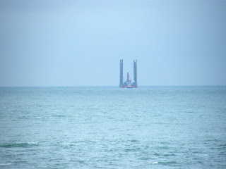 What we could see was a strange platform out at sea. Are they doing oil exploration in these
waters? — for that is what it looked like.
Then we met a man with his dog who asked (referring to the speedboats), “Does the future security of the realm
depend on this exercise, or are they just lads out for a laugh?” So we’re not the only ones who have
reservations about the behaviour of the Army.
What we could see was a strange platform out at sea. Are they doing oil exploration in these
waters? — for that is what it looked like.
Then we met a man with his dog who asked (referring to the speedboats), “Does the future security of the realm
depend on this exercise, or are they just lads out for a laugh?” So we’re not the only ones who have
reservations about the behaviour of the Army.

 We chatted for a while about the Army etc, and then it started to rain.
Away went the telescope and our cameras, out came the wet-weather gear which we
put on. Colin found a sheltered nook
overlooking a pillar of rock, so we sat there and ate our sandwiches. We continued across moorland and met quite a
few other people — there was obviously a car park nearby. And we saw some of the grazing ponies we had
been informed about further back.
We chatted for a while about the Army etc, and then it started to rain.
Away went the telescope and our cameras, out came the wet-weather gear which we
put on. Colin found a sheltered nook
overlooking a pillar of rock, so we sat there and ate our sandwiches. We continued across moorland and met quite a
few other people — there was obviously a car park nearby. And we saw some of the grazing ponies we had
been informed about further back.
 We walked
through some curvy gates and passed a throne-like seat. We were overtaken by a group of soldiers (not again!) and later caught them up as
they were setting up climbing gear in an old quarry. There was a good view from there — Colin was
convinced the ‘oil platform’ had moved.
We walked
through some curvy gates and passed a throne-like seat. We were overtaken by a group of soldiers (not again!) and later caught them up as
they were setting up climbing gear in an old quarry. There was a good view from there — Colin was
convinced the ‘oil platform’ had moved.
 The path suddenly turned twisty and steep with lots of steps made out of
beautiful twisty metamorphic rock. Damn the rain which was ruining everything! The views should have been spectacular, but
we couldn’t see them because we were rising into a damp wet cloud. We saw in the distance what we thought might
be an ancient chapel, but when we got up to it we found it to be a much more
modern stone shelter. We wondered if it
was Victorian, and took a picture looking out of it — photography was difficult
in the rain.
The path suddenly turned twisty and steep with lots of steps made out of
beautiful twisty metamorphic rock. Damn the rain which was ruining everything! The views should have been spectacular, but
we couldn’t see them because we were rising into a damp wet cloud. We saw in the distance what we thought might
be an ancient chapel, but when we got up to it we found it to be a much more
modern stone shelter. We wondered if it
was Victorian, and took a picture looking out of it — photography was difficult
in the rain.
 A young man passed us — he seemed to know where he was going whilst we were
bumbling about in the wet. (Actually,
Colin was changing his pad at the nether end of the shelter — every
opportunity……) We continued into the
fog. We thought we were a lot further on
than we actually were because we had put the map away at the onset of the rain
and were following the little blue logo signs.
The rain stopped momentarily — we looked back and could see that the
‘oil platform’ was now inshore at the end of a long pier. We still didn’t know what it was, and never
did find out.
A young man passed us — he seemed to know where he was going whilst we were
bumbling about in the wet. (Actually,
Colin was changing his pad at the nether end of the shelter — every
opportunity……) We continued into the
fog. We thought we were a lot further on
than we actually were because we had put the map away at the onset of the rain
and were following the little blue logo signs.
The rain stopped momentarily — we looked back and could see that the
‘oil platform’ was now inshore at the end of a long pier. We still didn’t know what it was, and never
did find out.
 The rain restarted and the fog closed in again. We could see a building ahead and thought it
was associated with South Stack Lighthouse and that we were nearly there. But we weren’t anywhere near, we had
seriously miscalculated. We descended to
the building which was for sale. (No thank you!) The track away from it led upwards quite
steeply and was very uneven. I think even 4x4 vehicles would have difficulty
driving up and down it. Part way up we
realised that we were only a few yards from the path we had come down on — if we
had followed yellow arrows instead of the blue Coast Path logo we could have
cut out that corner entirely, that would have been a good idea in the rain and
fog.
The rain restarted and the fog closed in again. We could see a building ahead and thought it
was associated with South Stack Lighthouse and that we were nearly there. But we weren’t anywhere near, we had
seriously miscalculated. We descended to
the building which was for sale. (No thank you!) The track away from it led upwards quite
steeply and was very uneven. I think even 4x4 vehicles would have difficulty
driving up and down it. Part way up we
realised that we were only a few yards from the path we had come down on — if we
had followed yellow arrows instead of the blue Coast Path logo we could have
cut out that corner entirely, that would have been a good idea in the rain and
fog.
 The track seemed to climb forever, then the blue logos diverted from the
track on to a more even path which sort of followed the contours. We could see South Stack Lighthouse in the
distance when the fog lifted momentarily.
It’s light was flashing and the foghorn was going, but it seemed so far
away. The path was very good now, almost
an even track. We were convinced we were
very near the road to South Stack, but we weren’t. The fog had really disorientated us.
The track seemed to climb forever, then the blue logos diverted from the
track on to a more even path which sort of followed the contours. We could see South Stack Lighthouse in the
distance when the fog lifted momentarily.
It’s light was flashing and the foghorn was going, but it seemed so far
away. The path was very good now, almost
an even track. We were convinced we were
very near the road to South Stack, but we weren’t. The fog had really disorientated us.
 Colin said he wanted to eat his apple as he walked along, he needed the
moisture. I can’t eat comfortably and
walk at the same time so I carried on fully expecting to come to the road
soon. Of course I didn’t, but I did come
to a blue logo on a sturdy post, so I sat on it to wait for Colin and began to
eat my apple. The young man whom we had
last seen when we were in the shelter came walking out of the gloom towards me —
I naturally assumed he was going back the way he came. But he stopped and said, “I’ve seen you
before! I must be walking in circles, I
think I’m a bit lost.” “We’re following
the blue arrows!” I said. “So was I,” he
replied, “but I seem to have got back here going the other way! I can’t see where I am, have you got a map?” (Colin had, by now, caught me up.) I got out our map, but we quickly realised
that he
hadn’t a clue how to read one!
We also noticed that he was very inadequately dressed for the weather
conditions — wearing a short thin hoodless jacket, jeans and trainers. We were wet enough in our waterproofs but he
was wet through, cold and quite scared!
He told us his name was Michael, and that he was holidaying by himself
in Llandudno. This morning he had caught
the train to Holyhead with a vague idea of walking round the island. He had no idea how big it was, nor how far
his walk would take him.
Colin said he wanted to eat his apple as he walked along, he needed the
moisture. I can’t eat comfortably and
walk at the same time so I carried on fully expecting to come to the road
soon. Of course I didn’t, but I did come
to a blue logo on a sturdy post, so I sat on it to wait for Colin and began to
eat my apple. The young man whom we had
last seen when we were in the shelter came walking out of the gloom towards me —
I naturally assumed he was going back the way he came. But he stopped and said, “I’ve seen you
before! I must be walking in circles, I
think I’m a bit lost.” “We’re following
the blue arrows!” I said. “So was I,” he
replied, “but I seem to have got back here going the other way! I can’t see where I am, have you got a map?” (Colin had, by now, caught me up.) I got out our map, but we quickly realised
that he
hadn’t a clue how to read one!
We also noticed that he was very inadequately dressed for the weather
conditions — wearing a short thin hoodless jacket, jeans and trainers. We were wet enough in our waterproofs but he
was wet through, cold and quite scared!
He told us his name was Michael, and that he was holidaying by himself
in Llandudno. This morning he had caught
the train to Holyhead with a vague idea of walking round the island. He had no idea how big it was, nor how far
his walk would take him.
“You’d better stick with us!” I said, “at least until we get to the road at South Stack Lighthouse.” So we carried on together, and eventually came to a tarmacked road. But it was not the road to the lighthouse. Now I was really puzzled — I still hadn’t cottoned on that I had misread the map further back, the fog was very disorientating. A couple with a dog appeared out of the mist. Colin asked them where the road went to, and they told us it was to a radio-tracking station. They hurried on, seeming to know where they were, but too fast for us. Blue arrows crossed the road, so we followed them and Michael admitted, “I came this way!”
 Carefully following the blue arrows, up and up we went into the fog — it
was quite spooky. (I thought we’d
finished with up, but not so.) We were
careful not to miss a footing, that could have been fatal! Then down quite steeply, big steps which I
found quite tricky. Then the path was
along jagged rocks which wasn’t very comfortable to walk.
Carefully following the blue arrows, up and up we went into the fog — it
was quite spooky. (I thought we’d
finished with up, but not so.) We were
careful not to miss a footing, that could have been fatal! Then down quite steeply, big steps which I
found quite tricky. Then the path was
along jagged rocks which wasn’t very comfortable to walk.
 A shelter/lookout post loomed out of the
mist. “I stood in that shelter!” said
Michael. So he had come this far and
then circled round somehow. We found
ourselves standing on a kind of platform above a foggy abyss — and
we had lost all sight of the blue arrows!! The foghorn now sounded very near, but all we
could see was mist — mist — mist. Even
we were scared now. I sat on a rock and
tried to keep calm. We got out the map
and compass to work out where we were and in which direction we should
continue. We didn’t want to walk off a
cliff, which would have been very easy in that fog. Michael seemed to have no idea what we were
doing. “I can tell you which way not to
go!” he said unhelpfully. I worked out
we should gingerly walk south, then bear round to the right. “Oh! I turned
left!” said Michael. We stumbled down a
rough path with the fog so thick we could barely see our feet. (The photos from hereon were taken on a
different day when it wasn’t foggy!)
A shelter/lookout post loomed out of the
mist. “I stood in that shelter!” said
Michael. So he had come this far and
then circled round somehow. We found
ourselves standing on a kind of platform above a foggy abyss — and
we had lost all sight of the blue arrows!! The foghorn now sounded very near, but all we
could see was mist — mist — mist. Even
we were scared now. I sat on a rock and
tried to keep calm. We got out the map
and compass to work out where we were and in which direction we should
continue. We didn’t want to walk off a
cliff, which would have been very easy in that fog. Michael seemed to have no idea what we were
doing. “I can tell you which way not to
go!” he said unhelpfully. I worked out
we should gingerly walk south, then bear round to the right. “Oh! I turned
left!” said Michael. We stumbled down a
rough path with the fog so thick we could barely see our feet. (The photos from hereon were taken on a
different day when it wasn’t foggy!)
 It
wasn’t until we actually stepped on to tarmac that we realised we were at the top
car park near South Stack Lighthouse, and where we were so lost was merely a
viewpoint above same! Relief! “To think I was so near!” said Michael, “and
then I turned the wrong way. It was the fog put me off!” We couldn’t see the lighthouse, nor Ellin’s
tower which was nearby. All was white —
white — white.
It
wasn’t until we actually stepped on to tarmac that we realised we were at the top
car park near South Stack Lighthouse, and where we were so lost was merely a
viewpoint above same! Relief! “To think I was so near!” said Michael, “and
then I turned the wrong way. It was the fog put me off!” We couldn’t see the lighthouse, nor Ellin’s
tower which was nearby. All was white —
white — white.

 Michael still had no idea how to get back to Holyhead Station, nor how
far it was — at least four miles by my reckoning. So I suggested he walk with us down to the
road junction where he should turn left and we would turn right towards
Trearddur. I only hope he has learnt a
lesson or two about wandering vaguely round a mountain without a map, but I
doubt it. I don’t think he realised the danger he had been in — all he could
talk about was wondering what his friends would think when he wrote about his
‘adventure’ on facebook!
Michael still had no idea how to get back to Holyhead Station, nor how
far it was — at least four miles by my reckoning. So I suggested he walk with us down to the
road junction where he should turn left and we would turn right towards
Trearddur. I only hope he has learnt a
lesson or two about wandering vaguely round a mountain without a map, but I
doubt it. I don’t think he realised the danger he had been in — all he could
talk about was wondering what his friends would think when he wrote about his
‘adventure’ on facebook!
 When he saw a
footpath off the road and “wondered if it might be a shortcut back to the
station” I got quite cross with him. I
said, “Look! You’re wet through and
cold. You’re on your own. No one knows where you are. If you get lost on that mountain again you
could die! So
stick to the road!!” We parted
at the road junction with those words, and we can only assume that he did get
back safely to his train. Nuthead!
When he saw a
footpath off the road and “wondered if it might be a shortcut back to the
station” I got quite cross with him. I
said, “Look! You’re wet through and
cold. You’re on your own. No one knows where you are. If you get lost on that mountain again you
could die! So
stick to the road!!” We parted
at the road junction with those words, and we can only assume that he did get
back safely to his train. Nuthead!
 Colin and I had no further interest in following the coastal path which
wiggled it’s way down this pretty coast — rain and fog are not conducive to
enjoyable walking! We route-marched
nearly four miles along the straighter road to the car. We did a little bit on a grassy path, but the
road cut all the corners and was safer in the fog. Couldn’t see anything anyway. We sat on a stone part way down to eat our
chocolate. Our waterproofs are no longer
as waterproof as they once were, nor are our boots. That was disappointing considering how much
they cost.
Colin and I had no further interest in following the coastal path which
wiggled it’s way down this pretty coast — rain and fog are not conducive to
enjoyable walking! We route-marched
nearly four miles along the straighter road to the car. We did a little bit on a grassy path, but the
road cut all the corners and was safer in the fog. Couldn’t see anything anyway. We sat on a stone part way down to eat our
chocolate. Our waterproofs are no longer
as waterproof as they once were, nor are our boots. That was disappointing considering how much
they cost.
That ended Walk no.342, we shall pick up Walk no.343 on the road just above Trearddur Bay. It was six o’clock (though it seemed much later), so the Walk had taken us seven hours fifty minutes. We had our tea and chocolate biscuits, then drove back to our caravan exhausted, soaking wet, fed up, and disappointed that our expensive waterproofs are no longer as waterproof as they used to be.
Location: Holyhead to Trearddur Bay.
Distance: 11 miles.
Total distance: 3535miles.
Terrain: Good paths into and out of Holyhead. Concrete in the port. A mountain path round South Stack cliffs which was very undulating and foggy. (We lost the blue arrows we were following, and it was a bit scary!) Road-walking after that, which was quite undulating.
Tide: In.
Rivers: No.419, Holyhead Port.
Ferries: None.
Piers: None.
Kissing gates: Nos.603, 604, 605 and 606 all near the beginning of the Walk.
Pubs: None.
‘Cadw’ properties: None.
Ferris wheels: None.
Diversions: None.
How we got there and back: We were staying in our caravan on a remote farm in the middle of Anglesey. Today’s Walk was almost a circular and there were no convenient buses going the way we wanted them to. So we drove to Trearddur Bay and parked beyond the double yellow lines on the road to South Stack cliffs. Then we took a footpath across the island to Penrhos Beach — this was about two miles.
At the end we finished the Walk at the car. It was six o’clock, so the Walk had taken us 7 hours and 50 minutes. We had our tea and chocolate biscuits, then drove back to our caravan exhausted, soaking wet, fed up, and disappointed that our expensive waterproofs are no longer as waterproof as they used to be.


Too Many Murders, too Many Funerals and too Many tears.
Just seen another brother buried plus I
knew him for
years pass by his father but what could I
say.
Keep your head up and try to
keep the faith and pray for better days.
From
Ricky
It was not very
clear, and we were not sure of the meaning, it just seemed a little sad.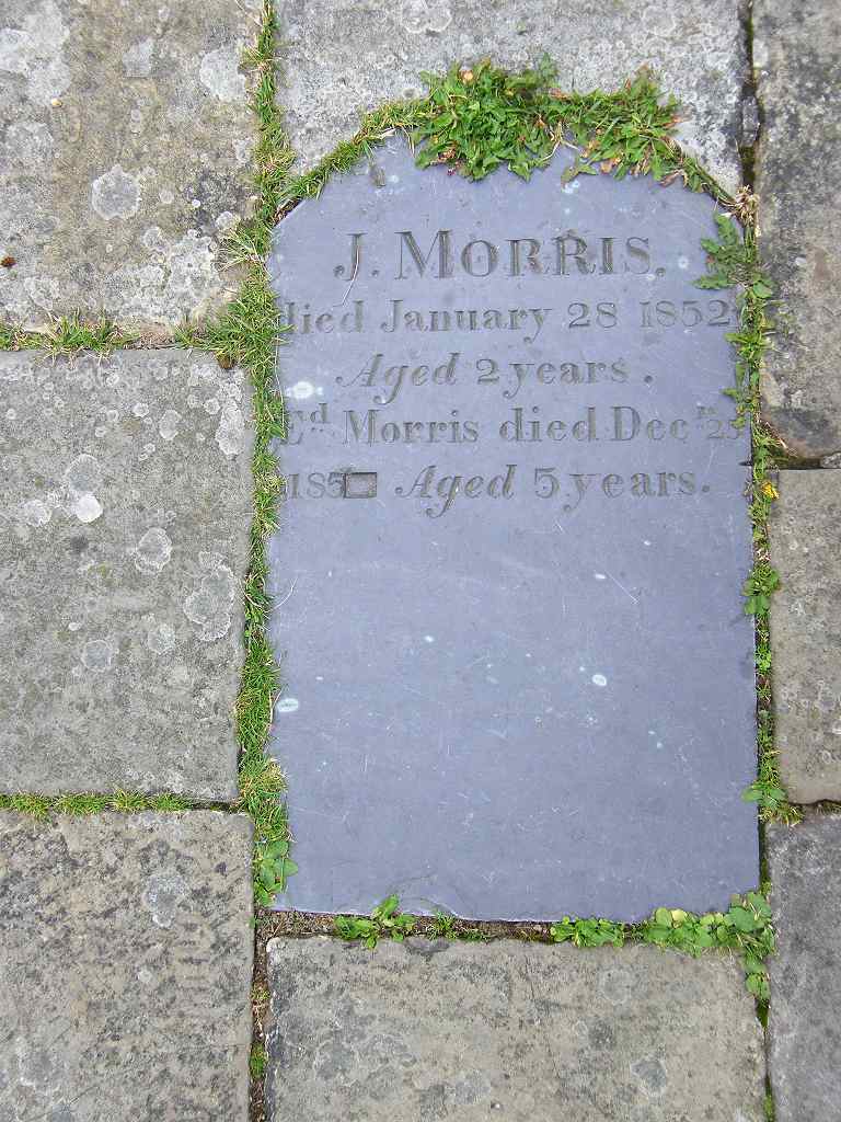

We descended steps down to the road through a castle-like gateway which dated from Roman times 2000 years ago. We passed modern boards with patterns on them as we walked along to the end where we were stopped by a spiky fence. But the way led on through a gap in the wall to our left.

There was a drinking fountain in the wall — we guessed it may be Victorian — but it was dry. We passed some allotments, and then a large marina where the yachts were dwarfed by a ferry ship bound for Ireland.


“You’d better stick with us!” I said, “at least until we get to the road at South Stack Lighthouse.” So we carried on together, and eventually came to a tarmacked road. But it was not the road to the lighthouse. Now I was really puzzled — I still hadn’t cottoned on that I had misread the map further back, the fog was very disorientating. A couple with a dog appeared out of the mist. Colin asked them where the road went to, and they told us it was to a radio-tracking station. They hurried on, seeming to know where they were, but too fast for us. Blue arrows crossed the road, so we followed them and Michael admitted, “I came this way!”


That ended Walk no.342, we shall pick up Walk no.343 on the road just above Trearddur Bay. It was six o’clock (though it seemed much later), so the Walk had taken us seven hours fifty minutes. We had our tea and chocolate biscuits, then drove back to our caravan exhausted, soaking wet, fed up, and disappointed that our expensive waterproofs are no longer as waterproof as they used to be.

No comments:
Post a Comment