Ages: Colin was 61 years and 120 days. Rosemary was 58 years and 262 days.
Weather: Hot and sunny, despite a breeze. Misty at the end.
Location: Aldeburgh to Dunwich.
Distance: 11½ miles.
Total distance: 609½ miles.
Terrain: Shingle bank, concrete prom, gravel paths, shingle, soft sand, soft sandy ‘cliffs’, heath, road, woods – in that order!
Tide: Out, coming in.
Rivers to cross: None.
Ferries: None.
Piers: None.
Kissing gates: No.83 in the final wood.
Pubs: The ‘Mill Inn’ in Aldeburgh where we enjoyed Adnams ‘Regatta’ and Strongbow cider.
‘English Heritage’ properties: No.21, Leiston Abbey – though this was situated two miles inland so we didn’t have to visit it, but we passed it on our bikes and it made an excuse for a rest!
Ferris wheels: None.
Diversions: None.
How we got there and back: We drove, with bikes on the back of the car, from our camp at Shottisham to Dunwich where the huge car park is free but they ask for donations to local charities. We then cycled a very long distance – part of it along a B.O.A.T. (Byway Open to All Traffic) in a wood which was a bit bumpy and scarey! We stopped at Leiston Abbey on the way, and found the information boards to be very interesting. On arrival in Aldeburgh, we chained our bikes to the fence where we had left our car yesterday.
At the end we sat drinking our tea, watching the mist rise and creep over the marshes where we have to walk next time. Then we drove to Aldeburgh to pick up the bikes, and returned to our campsite at Shottisham.
Leiston Abbey
 Leiston Abbey was founded by St Norbert in the 12th century. It was originally built at Minsmere (where the present-day wetlands nature reserve is) but, because the area was virtually a swamp, it was frequently flooded. After two hundred years of continually baling out, the monks had had enough; so they took the building down stone by stone and rebuilt it on higher ground two miles further inland. They didn’t recarve the stone – just erected exactly the same building that they had taken down. Most monasteries in the 14th century were a lot more elaborate in design, but Leiston retained the bolder simpler lines of the 12th century style.
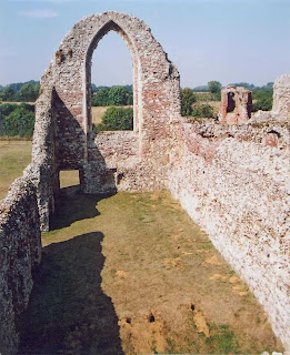 The monks were ‘Premonstratensian canons’, a very strict order apparently. (Neither of us had heard of them before.) During the four hundred years of the abbey’s functioning, there were never more than fifteen men living there at one time, and they were, unusually, all ordained priests. The community was dissolved at the time of the Reformation by Henry VIII’s mob – the usual story. In quieter years, a house was built across part of the ruined church, and another section was used as a barn. The house is now a ‘Centre of Music’ and the site is maintained by English Heritage who have furnished it with very well presented information boards – and they do not charge an entrance fee!
This morning, Colin wanted to prove that he could get up and going just as efficiently on a day when he didn’t have a Speedway meeting as an incentive! I’ll give him all credit for trying, but we had a very long walk with an even longer cycle ride (which wasn’t all flat) to contend with, and by the end of the day we were both lapsing. Part of the biking was on a BOAT (Byway Open to All Traffic) which led us downhill through a wood with mottled sunlight shining through the trees. It was very pretty, but rather bumpy and scarey! By the time we reached Leiston Abbey, we were in need of a rest – so we diverted to look at the ruins as an excuse. All in all, we didn’t manage to start the Walk until gone midday, and we regretted not having done the half mile down to the Martello tower and back yesterday.
 The Martello tower at Aldeburgh is bigger than any of the ones we have passed so far – dotted along the coast all the way from East Sussex in fact. It is a ‘triple’ tower, built in the shape of the Ace of Clubs to resist canon fire. It’s location must have been an important strategic position in Napoléonic times. Nowadays it is owned by the Landmark Trust, and you have to make an appointment if you want to have a look inside. We didn’t have time for that, so we continued southwards along the narrow shingle spit which stops the River Alde from flowing out into the sea, until we came to a gate. There was a National Trust notice informing us this was Orfordness. Also a notice reading:
 STRICTLY NO ACCESS
BEYOND THIS POINT
INCLUDING PEDESTRIANS
Fragile habitats and wildlife
easily damaged and disturbed
No mention – we noted – of radio masts, ordnance disposal or testing the triggers of atomic weapons! The words ‘including pedestrians’ had been added later by hand, and we were really glad we didn’t have to walk ten miles back on Orfordness. We felt as if we had been let off the hook! We turned north, happy in the knowledge that the rest of today’s Walk – and many subsequent Walks – would be in a straight line around the coast of East Anglia. We have finished with dillying and dallying for the next hundred miles or so. We were hungry, and there was no shade. As we passed the Martello tower on the way back, we found that we could sit out of the sun on its northern side if we used its wall as a backrest.
  Fortified after our lunch, we carried on along the spit towards Aldeburgh. There was a line of cars parked along the roadside, and among them was a bright yellow 1930s Austin 7, beautifully restored. Someone’s pride and joy, obviously.
  In Aldeburgh, we called in at the ‘Mill Inn’ for some real ale, nicely timed to wash down our lunch. Then we looked at the ‘Moot Hall’, a 16th century meeting place which has been restored. I was unable to take a photo of the front of it because there was a benchful of fat and ugly people in the way! I took a close-up of the sundial on the wall above their heads, then managed a quick shot of the building from the back in between tottering grockles coming and going and changing their minds in front of my camera lens.
  As we left the resort to the north, we passed a ‘fishermen’s car park’ where a traffic warden was doling out parking tickets to cars without the relevant permit and a young man, who had ‘only stopped for a minute’, was arguing with him. We felt smug – with our car parked at Dunwich where there is an honesty box for local charities. (Did we put a coin or two in it? – I can’t remember!)
 From there on we walked on the beach for many miles. Just before we reached Thorpeness I announced that we had reached the six hundred mile mark – it has taken us just over five years! We flopped on the beach, then persuaded a passer-by to take a picture of us looking as if we had just walked six hundred miles. Phew!
 The significant feature we were supposed to be looking out for in Thorpeness was a house built on top of a water tower – there is even a picture of it on the cover of the local OS ‘Explorer’ map which we were using, and very odd it looks too at seven stories high! It is called the ‘House in the Clouds’ – bit of an exaggeration, I think. However, we were pushed for time and this house is half a mile inland. So we carried on along the beach having decided to come and look at it another time. We never did!
 Further north, we took to the path along the top of the beach because it was easier walking there. At one point, the trail took a dive through a short tunnel under a stone balustrade which looked like a rather grand exit to the beach from the adjacent land. It was quite unexpected – not the sort of thing you would normally find on the beach. I looked on the map, and apparently we were passing a building and gardens called ‘Hall’, and nearby was ‘Dower House’ and ‘Home Farm’. That makes it sound as if it was part of an estate belonging to someone of importance in yesteryear. We wondered – with coastal erosion as it is on this vulnerable coast – if this ornate stone bridge had been in the middle of the stately gardens when it was built. It looked sort of 18th
 century style (not that I am an expert) so that would make it at least two hundred years old.
An awful lot of land has disappeared under the waves in this area over the last two centuries!
 We were at a place called Sizewell – infamous for its nuclear power station, the third we have passed so far on this trek. The first we saw of it was two metal structures in the sea, the inlet and outlet for the cooling water. This is why they build nuclear power stations on the coast – so that seawater can be used for cooling purposes. The problem is, it returns to the sea at a much higher temperature causing a completely different environment for aquatic animals. These evolve in large numbers, suited to the warmer water with less oxygen, and their presence attracts gulls.
  Then the tap is switched off and they die! It is all very unnatural. So was the buzzing noise we could hear, which got increasingly loud as we approached the buildings.
We rounded some sand dunes, and were astounded to find a row of beach huts well within hearing distance of the constant hum. What is more, on this balmy summer’s late afternoon, people were sunbathing and playing with their children on the sands! They seemed unconcerned, but my brain was already going spazzy with the noise, let alone the hidden electro-magnetic and radioactive rays!
There are two buildings at Sizewell. Sizewell A is a regular cuboid structure such as the two we had passed at Bradwell in Essex. This one is currently being decommissioned, but that will take years – certainly not in our lifetime nor that of our children. Sizewell B is a giant golf ball! That was where the buzzing was coming from. It was weird – like an alien spaceship from the planet Zog! We walked up the beach to find the path again, and near the perimeter fence (KEEP OUT – THIS IS A LICENSED NUCLEAR SITE) was a ‘nature’ board telling us what wildlife we could expect to see in the dunes – we must have passed hundreds of such boards along the way. But this one was headed – FLORA and FAUNA FLOURISHES at SIZEWELL . We bet it does! (Did you see that two-headed rabbit over there in the sand dune ? !) 
 We had got to the point in our Walk where we needed to eat our bars of chocolate to give us the energy for the last stretch. Tired as I was, I refused to stop until we could no longer hear the buzzing noise – which was a good half mile beyond the giant golf ball. Then we rested on a breakwater and topped up our blood-sugar levels with a bar of chunky Kit-Kat each. Fortified, we continued. We noticed an enormous amount of rubbish on the beach, mostly plastic packing. We think it had been thrown off ships in the North sea, it was catering packaging mostly, that sort of thing. Don’t these people realise that the sea is not a universal dustbin? I don’t suppose they care.
  To our left (West) was marshland. The sun was sinking in the sky tingeing the clouds with pink, and silhouetted against this vista was an old-fashioned wind-pump. Surely that is a much more friendly way of harnessing energy! Do we really need all this electricity we rely so much on these days? Our ancestors managed without it, and we have none in our luxurious tent where we are staying at the moment. I’m not saying we should do without it altogether – especially in Winter – but I’m sure we could all live fulfilled and comfortable lives using a lot less. Why do we need so many street lights blazing all night? Light pollution is now such a problem in some areas that birds get confused and children are growing up not knowing that there are stars in the sky.
Talking of which – we will soon be walking under the stars if we don’t get a move on! Colin looked through his binoculars over Minsmere Nature Reserve and saw a heron and some egrets. I had reached that stage of weariness when all I was interested in was getting to the end of the Walk.  Also I was finding the soft sand, into which our path had deteriorated, was very hard going. Minsmere is the swamp where the Leiston Abbey monks first built their monastery, apparently not realising that if you try to build on a bog you are sure to come to grief. Ah well, I suppose you can’t be that holy and
 blessed with common sense!
(And they managed quite well without electricity too.) As we approached Dunwich Heath, the path took us up a slope so that we were on the top of soft sandy cliffs. There the ‘Suffolk Coast & Heaths Path’ went off at a tangent inland, but we wanted to hug the shore – perhaps that was why we got lost.  According to the map there was just one path across the heath, but in actual fact there was a myriad of them all tied in knots! We were very tired and it was beginning to get dark, so we kept blaming each other for losing the way – which was a bit silly. Our consolation was the colour of the broom flowers in the evening light – absolutely stunning! After several dead ends, we eventually found the road we were looking for. There was a notice warning about the danger of lighting fires on the heath – necessary because we have just experienced the hottest summer on record and all this beauty with its associated wildlife could be lost in a few seconds by the action of just one careless person.
  We were back on track, and marched along the road (no traffic) until it was crossed by the ‘Suffolk Coast & Heaths Path’ which had come back to us. We followed it, turning off into the woods, and that is where we saw a number of miniature deer. We weren’t sure what sort they were, and there was no hope of photographing them because it was almost dark under the trees, but it was exciting to watch them until they sensed our presence and made off through the undergrowth.
We managed to navigate despite the lack of light, and came out on the road into Dunwich. We were on the medieval Middlegate Street which, eight hundred years ago, was one of the most important streets leading into the city of Dunwich.  It now leads to the top of the cliff and stops! A few yards down this track, some rather beautiful wrought iron gates loomed out of the darkness because they were painted white. They bore the words EAST FRIARS and there was a picture of a monk on each gate. I took a flash photo of them.
  We didn’t go all the way to the clifftop because a new path, not marked on the map, was signposted off through the woods to our left. Since we could barely see, we thought we had better follow it because we had no torches to navigate. It led us past the ruins of Grey Friars, a Franciscan monastery, and down to the car park.
That ended Walk no.82, we shall pick up Walk no.83 next time in the car park at Dunwich. We felt as if we had really got somewhere today because we had followed the coast for eleven miles in a straight line! As we sat drinking our tea, we watched a mist rise and creep over the marshes where we have to walk next time. It was dark and gloomy, and I couldn’t help thinking of the huge and important medieval city that was Dunwich with its eight churches, three chapels, five monasteries and two hospitals, its quay which was a mile long, its ships and busy market place, and its network of streets containing hundreds of houses – all now swept away by the sea. It was quite eerie and ghostly! So we drove to Aldeburgh to pick up the bikes, and saw a hare in the road in the headlights. Then we returned to our campsite at Shottisham.
As I was peeling potatoes by the light of a gas lamp, I suddenly felt I was fed up with camping after all. It wasn’t cold, but there had been a slight nip in the air this past couple of nights. I had always said the camping season ends on 31st August because the nights start closing in then, but I had made an exception this year because we must get to Lowestoft before we go to Kate’s in three weeks time. So I rang up Paul (who was already in bed although it was only half past nine) and suggested that we stay with him for the next few nights instead of just visiting him tomorrow then returning to the campsite, which had been our original plan. I felt a lot better then.We returned to Dunwich on our way to Kate’s later on in the month, and spent several hours exploring the history of that fascinating place.
The City of Dunwich
The Suffolk coastline in Roman Britain, two thousand years ago, was very different from that which we see today. The cliffs are made of soft sand, and waves continually cut away at the base so that they collapse at frequent intervals. Also, the north-south drift on this changing coastline causes the slow formation of shingle spits which silt up estuaries and natural harbours, drastically altering the courses of rivers. (A present-day example of this is Orfordness which stretches ten miles south from Aldeburgh, dramatically changing the course of the River Alde/Ore.)
It is believed that there was a Roman settlement at Dunwich, although any trace of their buildings have long since disappeared under the waves. Dunwich was probably on the southern side of an estuary at that time, and could have been a port of some importance. Roman artefacts have been found on the beach and in the vicinity of the present-day village – including pottery, coins and jewellery. Three Roman roads, including one from Caistor which was the regional centre at the time, lead towards Dunwich. It’s position on the East coast of Britannia would have been of strategic importance. Saxon and medieval writers refer to Dunwich as ‘Dumnocaistor’ – Caistor was a word they used for settlements which had once been Roman towns. There is other, more vague, evidence and it is all very circumstantial. However, it is generally believed that Dunwich may have enjoyed up to two centuries of prosperity in Roman times, either as a deep-water port or as a fort – or both.
By the time the Saxons had taken over from the Romans, the coastline at Dunwich had changed. A shingle spit was growing southwards from Southwold, altering the course of the River Blythe so that it entered the sea nearer to Dunwich. The former estuary began to silt up and become marshland. A small creek – the Dunwich River – which had always entered the sea at Dunwich, now joined with the River Blythe. Together they scoured out a deep channel which produced a natural sheltered harbour.That Dunwich was an important town in Saxon times is in no doubt. During the 7th century, King Sigbert – monarch of the East Saxons – wished to convert his subjects to Christianity by sending missionaries from Lindisfarne all down the East coast. The Venerable Bede wrote:
“Sigbert was a devout Christian and a man of learning, who had been an exile in Gaul during his brother’s lifetime, and was there converted to the Christian Faith, so that when he began his reign, he laboured to bring about the conversion of his whole realm. In this enterprise he was nobly assisted by Bishop Felix who came to Archbishop Honorius (of England) from the Burgundian region, where he had been brought up and ordained, and, by his own desire, was sent by him to preach the word of life to this nation of the Angles. Nor did he fail in his purpose; for, like a good farmer, he reaped a rich harvest of believers. His Episcopal see was established at Dunwich; and after ruling the province as its bishop for seventeen years, he ended his days there in peace.”
In 630, Felix was made the first Bishop of East Anglia by Archbishop Honorius, and so Dunwich was raised to the status of a city. During his time in Dunwich, St Felix (for he was canonised eventually) made the city a centre of learning by founding a school. It is also likely that he would have built a church, in the simple Saxon style. This was probably situated to the west of the city, near to a well to which were attributed healing powers. (Possibly this well was so far inland, its water was less brackish than that used by the citizens from sources nearer the sea.) Dunwich flourished, despite the fact that part of it was divided off and a second bishopric established at Elmham. The names of all the bishops of Dunwich have been recorded, and the bronze seal of the last, Aethilwald, is preserved in the British Museum. During the 9th and 10th centuries, the vulnerable east coast was invaded again and again by raiders from Scandinavia. This was the ‘Dark Ages’, and exactly what happened was never recorded, so it is still something of a mystery. However, the bishoprics of Elmham and Dunwich both collapsed, and although Elmham was later re-established, Dunwich never regained its Episcopal status.
By the time of the Norman Conquest, the growth of the shingle spit southwards from Southwold and the silting up of the marshes behind it had produced a fine deep-water harbour at Dunwich where the River Blythe entered the sea. But the waves had already taken their toll, for in the Domesday Book of 1086 it is recorded:
“Edric of Laxfield held Duneuric (at the time of King Edward) as a manor, and now Robert Malet holds it. Then 2 carucates of land, now one. The sea carried away the other. Then 12 bordars (smallholders), now 2.”
The city was said to be worth £50 and 60 000 herrings by way of a gift! Dunwich was prospering despite the erosive action of the sea. This was partly due to a community of Frenchmen who had settled there – Normans were given many privileges, like property which had been confiscated from the Saxons, and tax exemptions. Dunwich was the largest of the six boroughs of Suffolk, more important than Ipswich, Eye, Beccles, Clare or Sudbury. In 1101, Robert Malet, the Norman whose father had been granted the confiscated lands of Edric of Laxfield, was foolish enough to take up the cause of Robert, Duke of Normandy. (This duke was William the Conqueror’s eldest son who thought he should have inherited the English throne on the death of his father. He missed out again when his younger brother, William II, was murdered in the New Forest in 1100 because he was away in Normandy at the time. The news took a while to reach him, so his youngest brother, Henry I, got to Winchester first and plonked the crown on his own head – so there!) For his treason, Robert Malet was banished and Dunwich became Crown property. It was already extracting tolls from Blythburgh, Southwold, Walberswick and Orford for use of the ‘Haven’ – the huge area of estuary/marsh/harbour between Southwold and Dunwich. There was no doubt as to which of these towns was the most powerful!
In 1173, Prince Henry (son of the then King, Henry II) plotted to depose his father. He was encouraged by his mother, Queen Eleanor, who apparently couldn’t stand her husband. Waiting until his father was abroad and his right-hand-man was way up north repelling Scots, he enlisted the help of the Earl of Leicester for a coup d’état. The Earl landed at Walton where he teamed up with the Earl of Norfolk who had a castle there. They rode northwards, exhorting money from all the villages they passed through, and remained unopposed until they got to Dunwich. There, they threatened the citizens with the decapitation if they didn’t surrender; but the people replied that their King was still alive and that they would remain true to him. A local monk, Jordan Fantosme, wrote a poetic account of the ensuing siege which ends like this:
“– – The Earl of Leicester began to grow incensed
And causes gallows to be erected to alarm them
That day you might have seen burghers, right valiant knights
Issue forth to their fortifications, each knows his business
Some to shoot with bows, the others to hurl darts
The strong to help the weak to rest frequently
Within the town there was neither maid nor wife
Who did not carry a stone to the palisade for throwing
Thus did the people of Dunwich defend themselves
As these verses tell which are here written
And so brave were great and small
That Earl Robert retired completely mocked.”
In 1199 – the first year of the reign of King John – Dunwich was awarded its freedom. This meant the citizens had a right to a certain degree of self-government in return for regular payment to the King. (Dunwich paid four hundred marks, ten falcons and five gerfalcons – a crafty way of getting extra taxes for the King’s leisure activities which included war-mongering in foreign parts!) They were also granted a license to have a Guild of Merchants – this was a reward for their support of King John’s stance against the Barons over the enforcement of the Magna Carter. Some years later, the city won the liberty to be governed by a Mayor and four Bailiffs (more backhanders!) By 1298, Dunwich had reached such heights of importance, it returned two Members to Parliament.
From the middle of the 12th century and throughout the 13th century, Dunwich was not only a prosperous city but also a major port. The harbour would have been full of merchants’ ships from many countries, new ships made to order, older ships back for repair and fishing boats of all sizes. The quay was a mile long, and the city was well known for its ships and ship builders. Dunwich owned five galleys – the same number as London – and in 1241 it sent eighty ships to help the King Henry III with his wars in France. As many as three thousand people lived within the walls of the city, many of them foreign merchants. There would have been brisk trade in the bustling daily market – fish, fur and timber was brought in from the Baltic and as far away as Iceland; wine came from France (despite the King’s animosity with the French); fine cloth was imported from the Flemish weavers; etc, etc. Grain and wool would have been the main exports. There would have been warehouses, customs houses, a ship-building yard, a large market place, drinking houses, inns, windmills, luxurious tall timber-framed houses for the merchants’ residences and many smaller dwellings for the shopkeepers, millers, craftsmen, fishermen and their families; also hovels for the peasants. Eight churches, three chapels, five monasteries and two hospitals had been built for the service of this community. All this was encompassed by ramparts, which consisted of a ditch and an earth bank with a wooden palisade on top. There were at least four entrances – Bridge Gate, Middle Gate, Gilden Gate and Southern Gate – which were said to be housed over and strongly defended with gatekeepers and huge doors. Many travellers made their way to Dunwich as pilgrims because of its association with St Felix who had lived and died in Dunwich, although he was buried many miles away at Soham near Ely. They would have travelled along the old Roman roads, and on arrival would have ‘lived it up’ in this vibrant city – much as people travel to London, Paris or New York in the present day to have a holiday and a good time.
So where has it all gone? – this lively city with its large harbour and hundreds of buildings? For 21st century Dunwich is a tiny hamlet with one Victorian church, one pub (kept open mainly for tourists) and a huge empty beach! It was in the 14th century that things began to go wrong – up until then they had managed to keep on top of things. The main problem was the silting up of the harbour. The shingle spit which stretched from Southwold was growing longer, and mud brought down by the river was accumulating behind it. King Henry III had granted the sum of £47.10s for the repair of the harbour, which they did by constructing an earth bank and a wooden pier on the north side of the inlet and a wooden quay on the south side. Sand built up behind the pier forming a barrier which protected the harbour entrance – and this seemed to work for a time. In 1286 there was a big storm which caused considerable damage to the town. Many houses were swept into the sea, along with the churches of St Michael and St Bartholomew. It is likely that many of the inhabitants drowned, and even more were left homeless. Commerce was getting difficult because of the ever-shallowing harbour, and piracy only added to their problems. There was intense rivalry between Southwold, Walberswick and Dunwich for possession of the harbour and its associated tolls and customs. Dunwich had the upper hand because they had the King on their side, for they were still building ships – a galley in 1294 (which cost the vast sum of £277.5s.11½d) and eleven warships in 1296.
It was in January 1328 that Dunwich’s decline accelerated. A storm of monumental proportions threw up shingle and sand which completely blocked the harbour entrance – to such an extent that it has never been reopened. Water rushing down the River Blyth had nowhere to go, so it built up and then suddenly forced open a channel to the sea between Southwold and Walberswick – where it flows to this day. So Southwold now had the port, and the people of Dunwich were furious! They appealed to the King, who decreed that all fish landed at the new port could only be sold at Dunwich market. You can imagine the effect that had on relations between the two towns! There was much violence – probably a bit like the situation in Kosovo in the present day. In 1347, yet another huge storm disposed of four hundred houses, windmills, shops and two more churches – that of Saints Leonard and Martin. Countless people died that night. Only a quarter of the former city remained, it must have been devastating! Dunwich was now so small, it lost its right to be governed by a Mayor. The citizens were desperate. Several times they tried to cut through the spit, but always the sea filled in the hole on the next big tide. They continually harassed the ships coming in and out of Southwold, until even the King told them to leave them alone – probably because he was no longer getting much revenue from Dunwich and had therefore lost interest. At the end of the 14th century, the Black Friars (Dominican) Monastery, which had been situated on the south-east side of the town, was lost to the sea in yet another storm. Despite all these setbacks, Dunwich still carried on building ships and trading along the coast – particularly with Hull.
During the 15th century, Dunwich continued to decline as the sea carried on taking its toll. Dunwich sided with York whereas Southwold was a Lancastrian town, so when Henry Tudor took over the throne in 1485, he granted Southwold a ‘Charter of Incorporation’ – with the remission of all harbour dues to Dunwich. They had backed the wrong side! They fared no better under his son in the 16th century, for when Henry VIII dissolved the monasteries in the 1530s, Dunwich lost most of its remaining wealth along with its fishing industry. Grey Friars (Franciscans) became the town gaol for a while, then various other uses before it fell into ruin. St John’s was the biggest and most important church in the town, and had originally been built in a central location. However in 1540, the citizens began the task of dismantling the large stone structure with its cross-aisles to stop it falling over the cliffs. Under the chancel they found a stone coffin – the body inside was clutching two chalices to its chest and was wearing a pair of boots! More losses to the sea were recorded in 1560 and again in 1570, and even Queen Elizabeth I was moved to provide financial assistance.
In 1618, King James I allowed the citizens of Dunwich, Walberswick and Southwold to go on fund-raising forays throughout England and Wales to raise cash for the rebuilding of jetties and quays. After hundreds of years of animosity, the three towns were at last working together against their one common enemy – the sea. Erosion and the silting up of deep-water channels was affecting them all. Late 17th century, and it was the turn of St Peter’s church which had been built on the north side of town. It’s chancel fell over the cliffs in 1688, followed by half its steeple nine years later. Mesmerised and in shock, the few remaining citizens removed its bells, lead roof and timber before the rest of it crashed on to the beach in 1702. In 1718, a judgement was made that King George I (‘German George’ – who hardly ever visited England because he hated the place, and refused to learn to speak English) must forgo his right to fee-farm rents from Dunwich. This was because there was simply no money left, and ten Burgesses had been jailed for non-payment. In 1740 there was another massive storm. The sea crashed on to the shore breaking down sea walls and flooding the marshes. Waves decimated the last remnants of St Nicholas’s churchyard and also the ‘great road leading into the town from the quay’. St Leonard’s Marsh was covered in sand and shingle, ruining the pasture. The forty feet high ‘Cock & Hens Hills’ were reduced to ground level, and the foundations of St Francis’s Chapel was exposed. (It is not known when the three chapels – dedicated to St Francis, St Katherine and St Anthony – were taken by the sea.) In 1754, the Dunwich estate was bought by one Miles Barne Esq. In 1755, the last service was held in Dunwich’s one remaining church, All Saints, which had been built on the west edge of the town and so was furthest from the sea. The Rector left, and no one wanted the living because it was too poor! Subsequently, it was only used for baptisms, marriages and burials. The Maison Dieu hospital – founded by Henry II for ‘a master and six poor brethren’ and said to possess a cross with special powers – fell into disuse at about this time. It was situated where the main car park is now, but since it was a half-timbered building, all trace of it has disappeared.
The Barne family built most of the cottages which make up the present-day hamlet of Dunwich – well to the west of the original city. They also built a new church – dedicated to St James – and this was opened in 1831. All Saints was, by now, teetering on the edge and deemed too dangerous to use any longer. St James’s church is situated next to the ruins of the leper hospital – also dedicated to St James – which was built way out of town to the west so that the citizens could not be contaminated by those that were ‘unclean’. This hospital was a very wealthy establishment, having been endowed by a rich Squire in the reign of King John (probably to ease his conscience and ‘buy’ his place in heaven), and was built to house ‘a master and several leprous friars and sisters’. It was probably pillaged by Henry VIII’s mob and left to go to ruin. In 1832, Dunwich was declared a ‘rotten borough’ and lost its two Members of Parliament. In 1883, the Corporation was dissolved, and all remaining property and regalia was handed to Dunwich Town Trust. Artists, writers and poets ‘found’ Dunwich and often stayed there, turning it into a quirky little seaside resort with activities such as horse racing. Jerome K. Jerome spoke very fondly of the place.
 In 1923, just before the ruin of All Saints church fell over the cliffs and was washed away by the tides, the last corner of its tower was removed to the safety of the new St James’s churchyard where it remains today. All Saints churchyard is now the beach, but the remains of two gravestones can still be found at the top of the cliff. For the past hundred years, many people have reported finding human skulls and bones whilst walking along the base of the cliffs! In 1947, the Barne family sold the estate, and many of the inhabitants bought their own cottages. In 1964, the village school closed because it was too small to be viable. The hurricane of 1987 removed large quantities of shingle from the beach so that its level dropped more than two metres.
And so the erosion continues…
Three weeks later, we called again at Dunwich on our way to Kate’s, and spent a couple of hours exploring the village. First we stood on the shingle bank by the car park, looking out to sea. We could see … nothing! Just sea and sky. Yet if we had stood on that spot eight hundred years ago, in front of us would have been a bustling medieval town, a full square mile in size, of some three thousand inhabitants and a busy port of some significance including a huge ship-building yard. It was difficult to imagine!
 Next we went to explore the ruins of Grey Friars – not much left now. These Franciscans did not come to Dunwich until 1290 when the city was already well-established. They built their monastery just outside the western ramparts, probably because there wasn’t room anywhere else. They were more than a mile away from the sea at the time – now the ruins are touching the clifftop. They came to administer to the sick, and were routed at the Reformation two and a half centuries later.
 We walked through the woods to Middlegate Street, now a hollow path. We went to the place where we had left it in the dark at the end of our Walk, and continued towards the sea – or what would have been towards the city in medieval times. We came to a pretty little bridge leading over the top of it.
  Apparently there used to be three such bridges before the street hit Middle Gate, but this is the only one that hasn’t fallen over the cliff. A photo, taken in 1918, in one of my guide books shows the second one which disappeared as recently as 1969. We soon came to the cliff edge, and the road stops in mid-air – just like that! Again, it was difficult to imagine what used to lay ahead.
 We returned along the clifftop, looking for the remaining graves of All Saints churchyard. There they were! – under some thick bushes just outside the perimeter wall of Grey Friars.
  One was the last resting place of Jacob Forster who departed this life March 12th 1796, aged 38 years. The other was only a small piece and we couldn’t read it.
Finally we walked along the beach where the graveyard used to be, scanning the cliffs. It was Colin who spotted the most exciting find of all – a human skull in the sediment looking out to sea!!
 Leiston Abbey was founded by St Norbert in the 12th century. It was originally built at Minsmere (where the present-day wetlands nature reserve is) but, because the area was virtually a swamp, it was frequently flooded. After two hundred years of continually baling out, the monks had had enough; so they took the building down stone by stone and rebuilt it on higher ground two miles further inland. They didn’t recarve the stone – just erected exactly the same building that they had taken down. Most monasteries in the 14th century were a lot more elaborate in design, but Leiston retained the bolder simpler lines of the 12th century style.
 The monks were ‘Premonstratensian canons’, a very strict order apparently. (Neither of us had heard of them before.) During the four hundred years of the abbey’s functioning, there were never more than fifteen men living there at one time, and they were, unusually, all ordained priests. The community was dissolved at the time of the Reformation by Henry VIII’s mob – the usual story. In quieter years, a house was built across part of the ruined church, and another section was used as a barn. The house is now a ‘Centre of Music’ and the site is maintained by English Heritage who have furnished it with very well presented information boards – and they do not charge an entrance fee!
 The Martello tower at Aldeburgh is bigger than any of the ones we have passed so far – dotted along the coast all the way from East Sussex in fact. It is a ‘triple’ tower, built in the shape of the Ace of Clubs to resist canon fire. It’s location must have been an important strategic position in Napoléonic times. Nowadays it is owned by the Landmark Trust, and you have to make an appointment if you want to have a look inside. We didn’t have time for that, so we continued southwards along the narrow shingle spit which stops the River Alde from flowing out into the sea, until we came to a gate. There was a National Trust notice informing us this was Orfordness. Also a notice reading:
 STRICTLY NO ACCESS
 We were hungry, and there was no shade. As we passed the Martello tower on the way back, we found that we could sit out of the sun on its northern side if we used its wall as a backrest.
  Fortified after our lunch, we carried on along the spit towards Aldeburgh. There was a line of cars parked along the roadside, and among them was a bright yellow 1930s Austin 7, beautifully restored. Someone’s pride and joy, obviously.
 In Aldeburgh, we called in at the ‘Mill Inn’ for some real ale, nicely timed to wash down our lunch. Then we looked at the ‘Moot Hall’, a 16th century meeting place which has been restored. I was unable to take a photo of the front of it because there was a benchful of fat and ugly people in the way! I took a close-up of the sundial on the wall above their heads, then managed a quick shot of the building from the back in between tottering grockles coming and going and changing their minds in front of my camera lens.
  As we left the resort to the north, we passed a ‘fishermen’s car park’ where a traffic warden was doling out parking tickets to cars without the relevant permit and a young man, who had ‘only stopped for a minute’, was arguing with him. We felt smug – with our car parked at Dunwich where there is an honesty box for local charities. (Did we put a coin or two in it? – I can’t remember!)
 From there on we walked on the beach for many miles. Just before we reached Thorpeness I announced that we had reached the six hundred mile mark – it has taken us just over five years! We flopped on the beach, then persuaded a passer-by to take a picture of us looking as if we had just walked six hundred miles. Phew!
 The significant feature we were supposed to be looking out for in Thorpeness was a house built on top of a water tower – there is even a picture of it on the cover of the local OS ‘Explorer’ map which we were using, and very odd it looks too at seven stories high! It is called the ‘House in the Clouds’ – bit of an exaggeration, I think. However, we were pushed for time and this house is half a mile inland. So we carried on along the beach having decided to come and look at it another time. We never did!
 Further north, we took to the path along the top of the beach because it was easier walking there. At one point, the trail took a dive through a short tunnel under a stone balustrade which looked like a rather grand exit to the beach from the adjacent land. It was quite unexpected – not the sort of thing you would normally find on the beach. I looked on the map, and apparently we were passing a building and gardens called ‘Hall’, and nearby was ‘Dower House’ and ‘Home Farm’. That makes it sound as if it was part of an estate belonging to someone of importance in yesteryear. We wondered – with coastal erosion as it is on this vulnerable coast – if this ornate stone bridge had been in the middle of the stately gardens when it was built. It looked sort of 18th century style (not that I am an expert) so that would make it at least two hundred years old. An awful lot of land has disappeared under the waves in this area over the last two centuries!
 We were at a place called Sizewell – infamous for its nuclear power station, the third we have passed so far on this trek. The first we saw of it was two metal structures in the sea, the inlet and outlet for the cooling water. This is why they build nuclear power stations on the coast – so that seawater can be used for cooling purposes. The problem is, it returns to the sea at a much higher temperature causing a completely different environment for aquatic animals. These evolve in large numbers, suited to the warmer water with less oxygen, and their presence attracts gulls.
  Then the tap is switched off and they die! It is all very unnatural. So was the buzzing noise we could hear, which got increasingly loud as we approached the buildings.
 We had got to the point in our Walk where we needed to eat our bars of chocolate to give us the energy for the last stretch. Tired as I was, I refused to stop until we could no longer hear the buzzing noise – which was a good half mile beyond the giant golf ball. Then we rested on a breakwater and topped up our blood-sugar levels with a bar of chunky Kit-Kat each. Fortified, we continued. We noticed an enormous amount of rubbish on the beach, mostly plastic packing. We think it had been thrown off ships in the North sea, it was catering packaging mostly, that sort of thing. Don’t these people realise that the sea is not a universal dustbin? I don’t suppose they care.
 To our left (West) was marshland. The sun was sinking in the sky tingeing the clouds with pink, and silhouetted against this vista was an old-fashioned wind-pump. Surely that is a much more friendly way of harnessing energy! Do we really need all this electricity we rely so much on these days? Our ancestors managed without it, and we have none in our luxurious tent where we are staying at the moment. I’m not saying we should do without it altogether – especially in Winter – but I’m sure we could all live fulfilled and comfortable lives using a lot less. Why do we need so many street lights blazing all night? Light pollution is now such a problem in some areas that birds get confused and children are growing up not knowing that there are stars in the sky.
 Also I was finding the soft sand, into which our path had deteriorated, was very hard going. Minsmere is the swamp where the Leiston Abbey monks first built their monastery, apparently not realising that if you try to build on a bog you are sure to come to grief. Ah well, I suppose you can’t be that holy and blessed with common sense! (And they managed quite well without electricity too.)
 According to the map there was just one path across the heath, but in actual fact there was a myriad of them all tied in knots! We were very tired and it was beginning to get dark, so we kept blaming each other for losing the way – which was a bit silly. Our consolation was the colour of the broom flowers in the evening light – absolutely stunning! After several dead ends, we eventually found the road we were looking for. There was a notice warning about the danger of lighting fires on the heath – necessary because we have just experienced the hottest summer on record and all this beauty with its associated wildlife could be lost in a few seconds by the action of just one careless person.
  We were back on track, and marched along the road (no traffic) until it was crossed by the ‘Suffolk Coast & Heaths Path’ which had come back to us. We followed it, turning off into the woods, and that is where we saw a number of miniature deer. We weren’t sure what sort they were, and there was no hope of photographing them because it was almost dark under the trees, but it was exciting to watch them until they sensed our presence and made off through the undergrowth.
 It now leads to the top of the cliff and stops! A few yards down this track, some rather beautiful wrought iron gates loomed out of the darkness because they were painted white. They bore the words EAST FRIARS and there was a picture of a monk on each gate. I took a flash photo of them.
  We didn’t go all the way to the clifftop because a new path, not marked on the map, was signposted off through the woods to our left. Since we could barely see, we thought we had better follow it because we had no torches to navigate. It led us past the ruins of Grey Friars, a Franciscan monastery, and down to the car park.
 In 1923, just before the ruin of All Saints church fell over the cliffs and was washed away by the tides, the last corner of its tower was removed to the safety of the new St James’s churchyard where it remains today. All Saints churchyard is now the beach, but the remains of two gravestones can still be found at the top of the cliff. For the past hundred years, many people have reported finding human skulls and bones whilst walking along the base of the cliffs! In 1947, the Barne family sold the estate, and many of the inhabitants bought their own cottages. In 1964, the village school closed because it was too small to be viable. The hurricane of 1987 removed large quantities of shingle from the beach so that its level dropped more than two metres.
 Next we went to explore the ruins of Grey Friars – not much left now. These Franciscans did not come to Dunwich until 1290 when the city was already well-established. They built their monastery just outside the western ramparts, probably because there wasn’t room anywhere else. They were more than a mile away from the sea at the time – now the ruins are touching the clifftop. They came to administer to the sick, and were routed at the Reformation two and a half centuries later.
 We walked through the woods to Middlegate Street, now a hollow path. We went to the place where we had left it in the dark at the end of our Walk, and continued towards the sea – or what would have been towards the city in medieval times. We came to a pretty little bridge leading over the top of it.
  Apparently there used to be three such bridges before the street hit Middle Gate, but this is the only one that hasn’t fallen over the cliff. A photo, taken in 1918, in one of my guide books shows the second one which disappeared as recently as 1969. We soon came to the cliff edge, and the road stops in mid-air – just like that! Again, it was difficult to imagine what used to lay ahead.
 We returned along the clifftop, looking for the remaining graves of All Saints churchyard. There they were! – under some thick bushes just outside the perimeter wall of Grey Friars.
  One was the last resting place of Jacob Forster who departed this life March 12th 1796, aged 38 years. The other was only a small piece and we couldn’t read it.

1 comment:
I lived in Dunwich from the age of 4 in 1975 to 14 in 85. I lived in one of the houses on Middlegate, played in the house behind the gates as it was owned by my then step mother to be's family, learned to swim on the beach and played with my friends for hours on the cliff, at the bridge and all over the village. I really enjoyed your blog entry. Thank you Beth
Post a Comment