Ages: Colin was 66 years and 86 days. Rosemary was 63 years and 229 days.
Weather: Sunny intervals and a light breeze. Slightly cooler than it has been – ideal for walking. Slight showers this afternoon. (We were lucky, most areas had torrential showers!)
Location: Kingston on Spey, via Lossiemouth, to Hopeman.
Distance: 15 miles.
Total distance: 1639½ miles.
Terrain: Rough track along the top of the beach for miles. Then we walked on the beach, but it was soft sand because the tide was right in. Concrete in Lossiemouth, then a firm sandy beach. So far it had been flat, but the rough path along the clifftop to Hopeman was undulating.
Tide: In, going out.
Rivers: No.136, the Lossie in Lossiemouth.
Ferries: None.
Piers: None.
Kissing gates: None.
Pubs: None.
‘Historic Scotland’ properties: No.16, Spynie Palace, north of Elgin. No. 17, Elgin Cathedral, in Elgin. We visited both these properties on a ‘rest’ day as they are both a few miles inland.
Ferris wheels: None.
Diversions: No.53 at Covesea Skerries Lighthouse. We walked round it on the inland side by mistake – by the time we got there the tide was sufficiently far out for us to have gone along the beach, but I mistakenly thought we were further along where the beach ran out. The beach route would have been much easier!
How we got there and back: We were staying in a holiday cottage in Gardenstown. We got up very early as it was a long way to Hopeman and we wanted to catch a bus from there at ten past eight. We parked on the harbour, and walked up to the bus stop with ten minutes to spare. The bus was ten minutes late! It took us to Elgin Bus Station where we were supposed to have eleven minutes before catching a bus to Kingston on Spey. It was an anxious ride, but the Kingston bus waited for us as we struggled across to the other stand. (If we had missed the connection, that would have messed up our whole day.) We alighted from the second bus by the car park where we finished the last Walk.
At the end, we finished the Walk at the car. After drinking tea from our flask, we drove back to our cottage in Gardenstown. The journey is getting very long, takes an hour now!


From the car park where we finished the last Walk (no sign of the labrador puppy today), we walked westward alongside a brackish pond where there were swans and ducks with their young. The cygnets were already beginning to lose their brown feathers, but the ducklings must have been a second brood for they were still at the fluffy stage. The pond is part of the braided estuary of the River Spey.

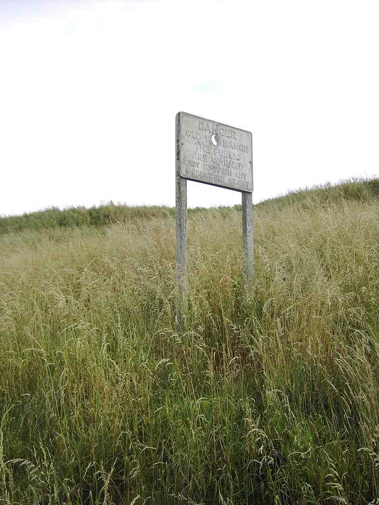
We followed a track, and were hoping that it would lead us through to Lossiemouth, but you never know with Scottish footpaths! After a mile or so we reached a rifle range. We came upon a concrete sentry box, which was empty until Colin climbed up into it. A notice warned us this was a military firing range, and that there is no access when red flags or lights are displayed. Well, none were, so we continued along the track.


All along the the six miles of beach to Lossiemouth are concrete bunkers, pill boxes and posts left over from the Second World War. I suppose this lonely beach would have been an ideal place for the enemy to land prior to invasion, so it was well defended. A quieter scene today, however. We saw a young robin on a bush, and Colin managed to photograph it.


At the other end of the rifle range we passed another sentry box facing the other way. There we went down on to the beach and sat on the stones to eat our steak pies. (Would have been nicer if we could have heated them up!) There was a lone fisherman on the beach. Apart from one other couple coming the other way later on, we saw nobody else until we approached Lossiemouth.


We returned to the track as there was too much shingle to walk on the beach comfortably. We walked for miles and miles between the forest and the sea. We were puzzled by a loud engine noise coming from somewhere yonder behind the trees. At first we thought it was a combine harvester or suchlike in a field, but it went droning on and on so we realised it wasn’t. Then we thought it must be aeroplanes, but they never took off. We knew that RAF Lossiemouth was situated over in that direction, but we thought the noise too loud to come from there — after all it was several miles away. But perhaps it was — we remembered being deafened by the jets at Leuchars, near St Andrews, when we were walking in the forest there. If it was RAF Lossiemouth, we felt really sorry for all the people living in the vicinity having to listen to that volume of noise every day. I remember a similar situation from my childhood in Farnborough, but having been born into that noisy environment I was so used to it I didn’t really hear it. I do now! I am very intolerant of noise, especially at night.


There is a phenomenal amount of concrete between Kingston and Lossiemouth. Rows of concrete posts to impede the progress of vehicles landing on the beach. Pill boxes all along, some looking decidedly worse for wear after nearly seventy years.

And up on the rise just before the forest are some bigger structures which look as if they had housed serious guns. There were signs of fires, and lager cans littered about. Graffiti artists had been at work though there was no real Art, it was all a bit of a mess. There were swastikas, and mis-spelt references to the ‘Fuhrer’ — I expect it was dysfunctional teenagers thinking they were clever.

Someone had written ‘THE UNKNOWN’ on the concrete posts, and we came across the inevitable burnt-out car.

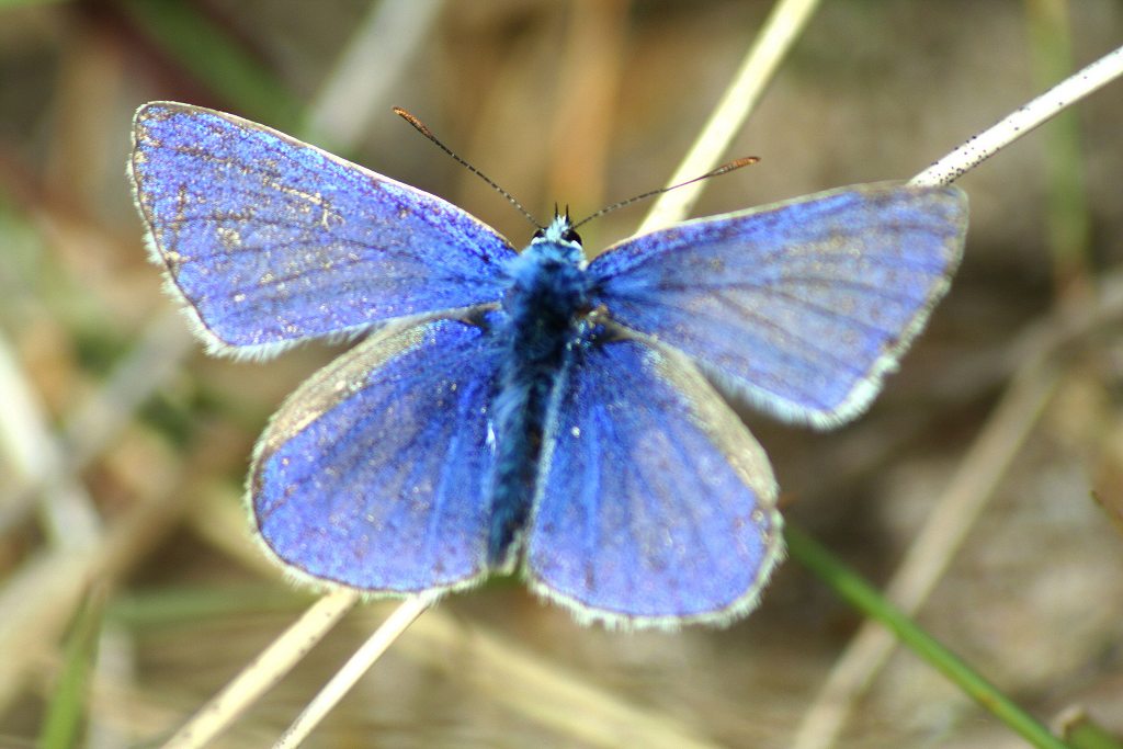
But we were more interested in the wildlife we encountered. Colin managed to photograph a stonechat and a gorgeous blue butterfly.
We began to feel a bit peckish, so we sat down and ate our sandwiches.


The forest started to recede, and we found we were walking along a grassy dune path just above a stony beach. Then the beach turned to sand and the path turned on to it. I thought the pattern of the pebbles was quite artistic! Trouble was, the tide was right in, so we found ourselves walking along soft sand on a slope.


We began to meet families enjoying the beach, but because the tide was in we had to walk right up close to them — there wasn’t much room. Colin was a few yards ahead of me when we passed an old man sitting on the beach with his family. He made some remark about me needing to hurry and catch up, so I told him we had walked all the way from Bognor Regis and gave him one of my blog cards.


It was a jolly scene as we approached Lossiemouth — a warm sunny day with the schools closed for holidays, and a lovely soft sandy beach. Ideal for families with children! We walked round the sand spit, passing the breakwater which marked where the River Lossie goes out to sea. We then approached the footbridge across the river — which we were relieved to find was actually there. (You never know with Scottish maps!) The nearest road bridge is about four miles up-river, so that would have been eight miles extra walking!


A notice on the bridge warned those crossing over to the beach from Lossiemouth of strong currents, and that bathing at or near the breakwater is dangerous. I wouldn’t have liked to go in the water anywhere near the river anyway, because it was full of jellyfish! Looking down off the bridge, we could see scores of them pulsating in the water. I find these strange animals fascinating to watch, but know that most of them can give you a nasty sting if you get too close.

On the other side, we sat on a bench and ate our apples.


We followed the western bank of the river, through Lossiemouth, to the seafront once again. We passed a pub called the ‘Clifton Bar’ — my maiden name! (Calm down all you scammers out there — I use much more obscure words than family names for my bank details!!) Colin had forgotten the name of the ‘real ale’ pub he had looked up in Lossiemouth. It wasn’t any of the pubs we passed, not even the ‘Clifton Bar’, and we never did find it. We also passed a wall on which was painted a seashore scene in bright blue.


Lossiemouth was holding Gala Day in aid of the local emergency services. It was in full swing with loud music playing, which we had been hearing from way back. We walked amongst a crowd milling around the usual kinds of stalls, throwing wet sponges at firemen, etc. We felt a bit sorry for them because it suddenly started to rain — hence no photos. But it didn’t last long, so hopefully it didn’t do too much damage to their fund-raising activities. Later on we looked back to see a helicopter hovering over the proceedings. Further on we came to a picnic table, so we sat down to eat our first chocolate bars. It had stopped raining by then.
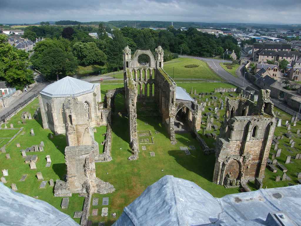
Elgin Cathedral


Approximately five miles inland from Lossiemouth lies the town of Elgin. A small cathedral was built there in 1224, but it was destroyed by fire in 1270. A new and much bigger cathedral was built, but this was also destroyed by fire, along with the town, in 1390.

On that occasion Alexander Stewart, Earl of Buchan and brother of Robert III (also known as the ‘Wolf of Badenoch’), attacked the town with a band of ‘wyld, wicked heland men’. There was another fire in 1402 when the cathedral was again attacked, this time by followers of the Lord of the Isles.


Spynie Palace


We visited Spynie Palace on the same day we visited Elgin Cathedral. It was quite interesting looking around, for much of the time we were the only people there. Again we were surprised how high we were able to climb and look at the view.


We still had a mile to go before we reached Hopeman. We were now almost down at sea level. It was a rocky beach, difficult to walk on, so we stuck to the path just above it.
 We passed the back of some beach huts, many of which had been brightly painted. One had the flag of Scotland painted over its complete back! Next we passed a recreation ground. On the far side of it was a very sophisticated set of skateboard ramps. A handful of youths were playing there, I only hope the facility is well used.


That ended Walk no.188, we shall pick up Walk no.189 next time at Hopeman by the harbour. It was twenty to seven, so the Walk had taken us nearly nine and a half hours. We thirstily drank tea from our flask, then it took us an hour to drive back to our cottage in Gardenstown.

No comments:
Post a Comment