Ages: Colin was 66 years and 321 days. Rosemary was 64 years and 98 days.
Weather: A cold strong wind and occasional showers. It brightened up later and the wind dropped.
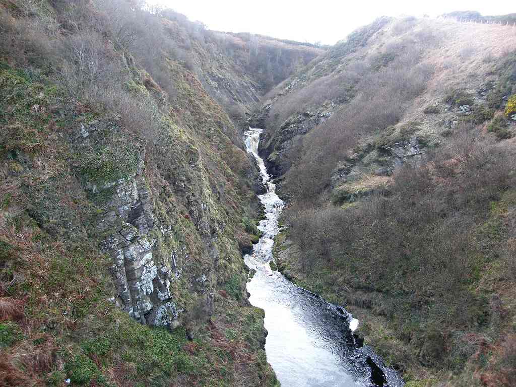
Location: Berriedale to Lybster.
Distance: 14½ miles.
Total distance: 1816½ miles.
Terrain: Mostly walking alongside the A9 which was quite soul-destroying. There was a nice path dipping through Dunbeath at lunchtime which gave us a little respite, and again at the end of the Walk dipping through Lybster.
Tide: In going out later.
Rivers: No.159, Dunbeath Water. No.160, Burn of Latheron. No. 161, Reisgill Burn.
Ferries: None.
Piers: None.
Kissing gates: No.172 near Dunbeath. No. 173 near Lybster.
Pubs: None.
‘Historic Scotland’ properties: None.
Ferris wheels: None.
Diversions: None.
How we got there and back: We were staying in a holiday cottage in Castletown. This morning we got up very early and drove about thirty miles to Lybster where nobody objected to us parking discreetly tucked away in a side street. We walked up to the main road and caught the bus to Berriedale.
At the end, we finished at the car. We had our tea and caramel squares, and remarked what a lovely evening it had turned out to be. Then we drove back to our cosy cottage in Castletown.

We started today’s Walk at the War Memorial in Berriedale. The door was open at the house where the “Can’t park here!” woman lives, but there was no sign of her. We blew a raspberry in her direction and walked out on to the main road! (Earlier this morning we had parked in front of someone’s house in Lybster, and no one objected to us doing so, neither then nor later when we returned.)

We walked up the steep hill out of the village and climbed some “granny’s teeth” to get into the cemetery. From there we could see an oil platform and several windmills far out to sea.

We exited the cemetery via a gate, and there seemed to be a path along the cliffs. But once more we were to be frustrated. We came to a fence which I got under with great difficulty because my back was playing up. There was a lot of mud around which was an added complication. I can’t climb fences or gates like I used to because my back is so stiff, and we are both wondering if it will last me out to complete the Round-Britain-Walk. I’m not giving in yet! We decided to return to the road as there obviously wasn’t a clear path. We climbed a hill, then we had to climb over a gate (oh dear!), skip through someone’s garden and we were back on the road less than half a mile from Berriedale! Fourteen miles to go!


We both went into ‘route-march’ mode for miles and miles and miles. There was very little of note. We passed a lot of sheep with their new-born lambs, and we passed some hairy ponies. The weather wasn’t too good, but at least it wasn’t icily cold like it has been. The wind was quite gusty and blew us sideways several times, which wasn’t very pleasant. The A9 is busy with lots of heavy lorries, and we didn’t enjoy walking along it at all!

About a mile before Dunbeath a bit of ‘old road’ leads off which would give us some respite from the traffic. It seemed we would never get there! But we did eventually, of course. It was overgrown where it led off the present road, but that was only to stop traffic using it. There was no problem for us walkers!


It was such a relief to get off that road! We walked alongside a stone wall with lots of fuzzy trees behind it. There were loads of daffodils about, the buds just opening up.


That ended Walk no.204, we shall pick up Walk no.205 next time in the village of Lybster. It was half past five, so the Walk had taken seven and a half hours. We had our tea and caramel squares, and remarked what a lovely evening it had turned out to be. We were hoping the weather would now be more settled, but that proved to be a vain hope! We drove back to our cosy cottage in Castletown.

1 comment:
I suspect I know the house of the "you can't park here" lady too. The door was open when I went here too and I suspect it is the same house. The A9 section was pretty dire and I decided not to even attempt to walk along the cliffs after your attempt from the little cemetery. I did at least pick to do this walk on a Sunday with the hope the traffic is lighter. Finding that old road down to Dunbeath is not easy. I couldn't see it on the main A9 at all (unusually, there was a pavement along here, it looked quite new, but on the other side of the road from the old road). So I had to use the GPS to work out when I was inline with the old road and then crossed and could squeeze beside the crash barriers to get down onto it!
Going back onto the A9 there was an interesting museum just up the hill with old crofters houses. Just before Latheron Wheel I saw a path signed off to the right so decided to follow it down into the village. It was a very good path obviously recently improved, with gravel all along through the woodlands and even a picnic bench by the river, it was lovely. On crossing over to the little harbour and following the road up I was surprised to spot a white arrow painted onto a fence post pointing along the coast.
I was not sure how long the path continued, there were stiles to go between the fields and even a little plank bridge. The path seemed to be marked by white squares painted onto fence posts, or a white top painted on the fence posts. I was able to follow this to Burn of Latheneron, where the path headed up the west side of the valley but was then signed to cross via a few rocks just before the cemetery. Then back down to the coast and a rougher path on the cliff, with one fence to climb but the rest had stiles. The valley at Forse had a proper footbridge. But at Burn of Achasinegar I lost the white posts, so followed the valley inland. Nearing the road I decided to descend the valley, cross myself (the stream was so narrow you could step over) and make the awkward climb up the other side of the valley. From here the "white post" path seemed to resume and I could follow it all the way to the view point and down into the harbour at Lybster.
No signs for it at all, it's not on the "Core Paths" map of the area but at least it is an alternative to the A9. It's rough underfoot in places so hard going but some lovely views. Just thought I'd share this for anyone else planning to walk this part of the coast.
Post a Comment