Weather: Started dull and breezy, but turned sunny and became too hot as the breeze abated.
Location: Laxford Bridge to Scourie.
Distance: 11½ miles.
Total distance: 2026 miles.
Terrain: The first part was roads which were a little undulating. The second part was lanes which were quite undulating. The third part was a rocky, boggy, uneven path which was very undulating. But there were views to blow our minds all the way.
Tide: Going out.
Rivers: None.
Ferries: None.
Piers: None.
Kissing gates: None.
Pubs: The Scourie Hotel where Colin enjoyed ‘Yellow-hammer’ and ‘Red Kite’, both from the Black Isle Brewery — when he eventually realised the pub was there. We had been staying within walking distance of it for three days before he found it, even though it was in the Good Beer Guide!! (Should I be worried about him?)
‘Historic Scotland’ properties: None.
Ferris wheels: None.
Diversions: None.
How we got there and back: We were staying in our caravan in Scourie. This morning we did actually catch the school bus from Scourie village to Laxford Bridge. The driver refused to accept any money for a fare “for all sorts of reasons” which he didn’t specify. (Perhaps he was horrified at the paperwork this would involve!) We didn’t mind.
At the end, we finished the Walk at the caravan. We didn’t use the car at all.

 The first four miles of today’s Walk were along the road. There was not much traffic, but when it did come it was FAST! We had to be very aware all the time. The road has been upgraded fairly recently, and we were able to walk away from the speeding cars on a bit of ‘old road’ occasionally. But we usually ended up in a gorse bush after a promising few yards, so it wasn’t actually much help.
 We amused ourselves by photographing the flowers we passed, which were prolific and beautiful. I especially liked the ‘cotton-tops’ (don’t know their real name) which we have only seen in Iceland before we came to the far north of Scotland. They were growing in a wet ditch, and looked lovely — at least I thought so! I consider them to be a true Arctic flower.
 Just to show that it wasn’t all pretty, I photographed a slug. Ugh! I hate slugs!
We came to a small lochan with a layby next to it. A car pulled into it and three people spilled out, a man and two women. They started raving about a ‘thrift’ they could see in the loch. I thought they meant a fish, but in fact they were talking about a flowering plant! (I looked this up later on the internet, and it turns out to be a drought-tolerant plant which needs a well-drained soil to prevent root-rot — in north-west Scotland?)
 These people told us that they had recently retired and had moved up to this area from the Isle of Wight. Quite a change of lifestyle, I should imagine.

 This is a wild and beautiful place, we only passed one house in that first four miles. We saw evidence of peat-cutting, but it seemed to be on a very small scale. Probably only the locals cut enough for their own needs.

Colin concentrated on getting pictures of birds, but he was unable to name them. The scenery was mind-blowing — rocks and lochs would describe it best, I think.
 We were interested to see how the bedding planes had been tipped and twisted in a road cutting.
 We were puzzled by a digger up on a bank, couldn’t think what it was doing. The land around here is so untamed, I shouldn’t think there is much you can do with it anyway. But the butterflies like it, we saw quite a few.
 As we turned into the lane to Tarbet, the sun came out. That’s better! We immediately felt cheerful, and the scenery instantly became even more startlingly magnificent.

 Added to that, there was hardly any traffic on the lane, so we could really relax and enjoy our Walk. We passed a small lochan where water lilies were growing. It was very pretty so we sat down to eat our elevenses there.

Everything was so wonderful we couldn’t stop taking photographs — me of the rocks and the lochs, the mountains and the islands, in fact the sheer beauty of the scenery. It was mind-boggling. Colin took the flowers and the birds, also the butterflies. We were in heaven!


 We didn’t take the lane which led directly to Tarbet, instead we followed the other lane which was a longer way round because it was nearer the sea. It was very much an up-and-down route, a bit like a roller-coaster, but we didn’t mind at all because the sun continued to shine and the scenery got better, if anything.

 We came to the hamlet of Foindle. Colin, in jocular mood, covered up the ‘i’ in the place name and tried to put on his ‘Mr Bean’ face. But I thought the landscape was far more stunning to look at. I continued to take picture after picture.


 On our map, a footpath is marked leading down to a place called Fanagmore Bay. But when we got to the place where it was supposed to lead off the lane there was no sign of it. (I won’t rant about the shortcomings of our expensive OS maps again because we were too happy in the middle of this wonderful panorama to spoil the mood.)
 We could only see fences across, so we very quickly decided we didn’t have to go down there as there wasn’t a path. After soaking in the view of what seemed like dozens of rock islands, we turned the corner and made towards Tarbet.

 We passed yet another lochan. Colin took a picture of a sheep that I thought was a goat. (Perhaps it was a geep — or a shoat!) In fact we didn’t see any other sheep about in this area, perhaps it is too rocky. As a result, the undergrowth is not nibbled down to nothing.
 Colin photographed a dragonfly which had settled on a granite rock, but I was more interested in the granite itself. Some of it was pink and some of it white — with the black crystals in it, of course. A beautiful rock!


 It was an abrupt descent into Tarbet, and we could see the other lane rising steeply out of the further side. Colin saw swallows flying out of a derelict cottage, so he went inside to see if he could find their nest. He found it on top of the electricity meter! He said there was still furniture in the dwelling, including books on the shelves, even though the house was quite derelict. I wonder what the story is behind it.
Tarbet was a popular place that warm afternoon, both car parks were full. There were lots of bikers, many being foreign nationals on holiday. Colin was in his element! He got talking to an elderly (well, about our age!) biker who was a widower. Ever since he lost his wife he has been touring round on his motorbike, unable to settle anywhere.
 We sat on the beach to eat our lunch. Tarbet seemed a laid-back sort of place and we ended up staying there for one and a half hours. We watched a group of Germans faffing about with canoes — eventually they launched them and went out for a paddle. Some people were sitting about waiting for the ferry to Handa Island which is just offshore. The island is no longer inhabited, but is a seabird sanctuary managed by the Scottish Wildlife Trust. In the distance to the south we could see the rock stack called ‘The Old Man of Stoer’, looking like some ghostly figure standing out from the cliff.
 But we had a Walk to finish, we had dallied long enough. The last part of today’s Trek was to follow a footpath across the rocky landscape to Scourie. This is an official footpath which is signposted and waymarked, so we felt confident (well, sort of) that it wouldn’t let us down. We found it to be steep, rocky, boggy and beautiful — it was certainly more challenging than we had anticipated.
 We had a steep ascent to start with, but we were rewarded with glorious views across to Handa Island, and lots of other rocky islands.
 It got very hot as there was no wind, even high up. We were caught out because neither of us had brought enough water to drink. Yesterday’s Walk had been so wet, and today had started out very grey and dull. We couldn’t believe how the weather had changed so quickly! We started to ration what little water we had left.
 Sometimes the path was rocky, and sometimes it was so boggy our boots sank in — but never too deep. It was very uneven, our pace was slow. Colin photographed a sundew plant which looked fantastic in the sunshine.
 We came across a rusty gate stuck in a rock. It was all by itself, no fences attached to it on either side. It did look odd. We dutifully opened it and walked through, carefully closing it behind us!

 We continued walking uphill, but never did get to the top. The path led us into a hollow where it was baking hot, and that is where we ran out of water. We sat on a rock overlooking the lochan that was there and ate chocolate to give us the energy to continue. Small plants were growing in the water, reflected in the surface making them look twice as tall.

 We thought we would soon start to go down, but every time we topped a rise there was another one ahead. I seem to remember we had that same experience when we were walking from Cape Wrath to Sandwood Bay — we were finding this last part of today’s Walk equally challenging. Perhaps it was because we were beginning to get dehydrated.

 We followed the cairns which waymarked the route, and passed several lochans. We sank in the bog and clambered over rocks. Up and down, up and down. Amazing views but we were really feeling the heat. Colin photographed another dragonfly, another sundew plant and ‘The Old Man of Stoer’ again.


 At last! We topped a rise, and there was our caravan site below! It looked an awful long way down.
 It proved to be very steep, not at all easy. Lower down we had to battle our way through gorse bushes (ow!) which closed above our heads. We soldiered on, and eventually spilled out on to a track near a farm. It was quite an easy walk down to the beach from there.
 A man sitting on a bench asked me if I was a bird-watcher — I was near to collapse with dehydration. I could hardly answer him, my throat was so dry. I left him talking to Colin, and hurried to the caravan where I drank a whole bottle of water in one go. Never again will I walk with only one bottle of water!
That ended Walk no.222, we shall pick up Walk no.223 next time at the caravan site in Scourie. It was six o’clock, so the Walk had taken nine and a half hours. I slept for an hour on my bed, then I felt quite human again. The next day we had a real rest day. I remarked that the local pub had a notice about real ales. Colin was adamant that it wasn’t in the Good Beer Guide, but it was and it had some good ales on tap. Colin had been staying next to one of his CAMRA pubs for three days without realising it! Should I be worried about him?
Location: Laxford Bridge to Scourie.
Distance: 11½ miles.
Total distance: 2026 miles.
Terrain: The first part was roads which were a little undulating. The second part was lanes which were quite undulating. The third part was a rocky, boggy, uneven path which was very undulating. But there were views to blow our minds all the way.
Tide: Going out.
Rivers: None.
Ferries: None.
Piers: None.
Kissing gates: None.
Pubs: The Scourie Hotel where Colin enjoyed ‘Yellow-hammer’ and ‘Red Kite’, both from the Black Isle Brewery — when he eventually realised the pub was there. We had been staying within walking distance of it for three days before he found it, even though it was in the Good Beer Guide!! (Should I be worried about him?)
‘Historic Scotland’ properties: None.
Ferris wheels: None.
Diversions: None.
How we got there and back: We were staying in our caravan in Scourie. This morning we did actually catch the school bus from Scourie village to Laxford Bridge. The driver refused to accept any money for a fare “for all sorts of reasons” which he didn’t specify. (Perhaps he was horrified at the paperwork this would involve!) We didn’t mind.
At the end, we finished the Walk at the caravan. We didn’t use the car at all.

 The first four miles of today’s Walk were along the road. There was not much traffic, but when it did come it was FAST! We had to be very aware all the time. The road has been upgraded fairly recently, and we were able to walk away from the speeding cars on a bit of ‘old road’ occasionally. But we usually ended up in a gorse bush after a promising few yards, so it wasn’t actually much help.
 We amused ourselves by photographing the flowers we passed, which were prolific and beautiful. I especially liked the ‘cotton-tops’ (don’t know their real name) which we have only seen in Iceland before we came to the far north of Scotland. They were growing in a wet ditch, and looked lovely — at least I thought so! I consider them to be a true Arctic flower.
 Just to show that it wasn’t all pretty, I photographed a slug. Ugh! I hate slugs!
We came to a small lochan with a layby next to it. A car pulled into it and three people spilled out, a man and two women. They started raving about a ‘thrift’ they could see in the loch. I thought they meant a fish, but in fact they were talking about a flowering plant! (I looked this up later on the internet, and it turns out to be a drought-tolerant plant which needs a well-drained soil to prevent root-rot — in north-west Scotland?)
 These people told us that they had recently retired and had moved up to this area from the Isle of Wight. Quite a change of lifestyle, I should imagine.
 This is a wild and beautiful place, we only passed one house in that first four miles. We saw evidence of peat-cutting, but it seemed to be on a very small scale. Probably only the locals cut enough for their own needs.
Colin concentrated on getting pictures of birds, but he was unable to name them. The scenery was mind-blowing — rocks and lochs would describe it best, I think.
 We were interested to see how the bedding planes had been tipped and twisted in a road cutting.
 We were puzzled by a digger up on a bank, couldn’t think what it was doing. The land around here is so untamed, I shouldn’t think there is much you can do with it anyway. But the butterflies like it, we saw quite a few.
 As we turned into the lane to Tarbet, the sun came out. That’s better! We immediately felt cheerful, and the scenery instantly became even more startlingly magnificent.
 Added to that, there was hardly any traffic on the lane, so we could really relax and enjoy our Walk. We passed a small lochan where water lilies were growing. It was very pretty so we sat down to eat our elevenses there.
Everything was so wonderful we couldn’t stop taking photographs — me of the rocks and the lochs, the mountains and the islands, in fact the sheer beauty of the scenery. It was mind-boggling. Colin took the flowers and the birds, also the butterflies. We were in heaven!


 We didn’t take the lane which led directly to Tarbet, instead we followed the other lane which was a longer way round because it was nearer the sea. It was very much an up-and-down route, a bit like a roller-coaster, but we didn’t mind at all because the sun continued to shine and the scenery got better, if anything.
 We came to the hamlet of Foindle. Colin, in jocular mood, covered up the ‘i’ in the place name and tried to put on his ‘Mr Bean’ face. But I thought the landscape was far more stunning to look at. I continued to take picture after picture.


 On our map, a footpath is marked leading down to a place called Fanagmore Bay. But when we got to the place where it was supposed to lead off the lane there was no sign of it. (I won’t rant about the shortcomings of our expensive OS maps again because we were too happy in the middle of this wonderful panorama to spoil the mood.)
  We could only see fences across, so we very quickly decided we didn’t have to go down there as there wasn’t a path. After soaking in the view of what seemed like dozens of rock islands, we turned the corner and made towards Tarbet.
 We passed yet another lochan. Colin took a picture of a sheep that I thought was a goat. (Perhaps it was a geep — or a shoat!) In fact we didn’t see any other sheep about in this area, perhaps it is too rocky. As a result, the undergrowth is not nibbled down to nothing.
 Colin photographed a dragonfly which had settled on a granite rock, but I was more interested in the granite itself. Some of it was pink and some of it white — with the black crystals in it, of course. A beautiful rock!

 It was an abrupt descent into Tarbet, and we could see the other lane rising steeply out of the further side. Colin saw swallows flying out of a derelict cottage, so he went inside to see if he could find their nest. He found it on top of the electricity meter! He said there was still furniture in the dwelling, including books on the shelves, even though the house was quite derelict. I wonder what the story is behind it.
Tarbet was a popular place that warm afternoon, both car parks were full. There were lots of bikers, many being foreign nationals on holiday. Colin was in his element! He got talking to an elderly (well, about our age!) biker who was a widower. Ever since he lost his wife he has been touring round on his motorbike, unable to settle anywhere.
 We sat on the beach to eat our lunch. Tarbet seemed a laid-back sort of place and we ended up staying there for one and a half hours. We watched a group of Germans faffing about with canoes — eventually they launched them and went out for a paddle. Some people were sitting about waiting for the ferry to Handa Island which is just offshore. The island is no longer inhabited, but is a seabird sanctuary managed by the Scottish Wildlife Trust. In the distance to the south we could see the rock stack called ‘The Old Man of Stoer’, looking like some ghostly figure standing out from the cliff.
 But we had a Walk to finish, we had dallied long enough. The last part of today’s Trek was to follow a footpath across the rocky landscape to Scourie. This is an official footpath which is signposted and waymarked, so we felt confident (well, sort of) that it wouldn’t let us down. We found it to be steep, rocky, boggy and beautiful — it was certainly more challenging than we had anticipated.
 We had a steep ascent to start with, but we were rewarded with glorious views across to Handa Island, and lots of other rocky islands.
  It got very hot as there was no wind, even high up. We were caught out because neither of us had brought enough water to drink. Yesterday’s Walk had been so wet, and today had started out very grey and dull. We couldn’t believe how the weather had changed so quickly! We started to ration what little water we had left.
 Sometimes the path was rocky, and sometimes it was so boggy our boots sank in — but never too deep. It was very uneven, our pace was slow. Colin photographed a sundew plant which looked fantastic in the sunshine.
 We came across a rusty gate stuck in a rock. It was all by itself, no fences attached to it on either side. It did look odd. We dutifully opened it and walked through, carefully closing it behind us!
 We continued walking uphill, but never did get to the top. The path led us into a hollow where it was baking hot, and that is where we ran out of water. We sat on a rock overlooking the lochan that was there and ate chocolate to give us the energy to continue. Small plants were growing in the water, reflected in the surface making them look twice as tall.
 We thought we would soon start to go down, but every time we topped a rise there was another one ahead. I seem to remember we had that same experience when we were walking from Cape Wrath to Sandwood Bay — we were finding this last part of today’s Walk equally challenging. Perhaps it was because we were beginning to get dehydrated.
 We followed the cairns which waymarked the route, and passed several lochans. We sank in the bog and clambered over rocks. Up and down, up and down. Amazing views but we were really feeling the heat. Colin photographed another dragonfly, another sundew plant and ‘The Old Man of Stoer’ again.

 At last! We topped a rise, and there was our caravan site below! It looked an awful long way down.
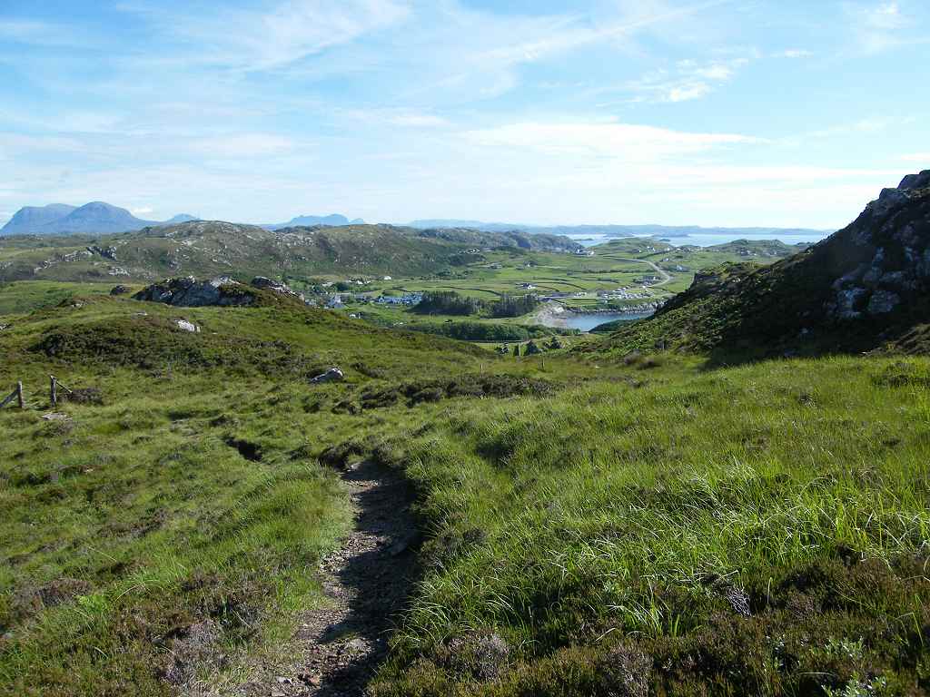 It proved to be very steep, not at all easy. Lower down we had to battle our way through gorse bushes (ow!) which closed above our heads. We soldiered on, and eventually spilled out on to a track near a farm. It was quite an easy walk down to the beach from there.
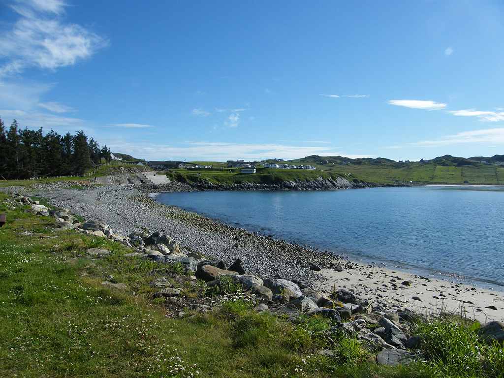 A man sitting on a bench asked me if I was a bird-watcher — I was near to collapse with dehydration. I could hardly answer him, my throat was so dry. I left him talking to Colin, and hurried to the caravan where I drank a whole bottle of water in one go. Never again will I walk with only one bottle of water!
That ended Walk no.222, we shall pick up Walk no.223 next time at the caravan site in Scourie. It was six o’clock, so the Walk had taken nine and a half hours. I slept for an hour on my bed, then I felt quite human again. The next day we had a real rest day. I remarked that the local pub had a notice about real ales. Colin was adamant that it wasn’t in the Good Beer Guide, but it was and it had some good ales on tap. Colin had been staying next to one of his CAMRA pubs for three days without realising it! Should I be worried about him?

No comments:
Post a Comment