Weather: Sunny and warm, but a strong wind which made
us feel cold.
Location: Glasson to Fleetwood.
Distance: 14 miles.
Total distance: 3273 miles.
Terrain: Lots of concrete. Lots of tracks (but none muddy!) Lovely sea-bank. One barbed wire fence. Nearly all flat.
Tide: Out, coming in.
Rivers: No.395, River Wyre.
Ferries: No.23 across the Wyre from Knott End-on-Sea to Fleetwood. Fare £1.50 each.
Piers: None.
Kissing gates: Nos. 404, 405 & 406 between Glasson and Cockerham.
Pubs: None.
‘English Heritage’ properties: None.
Ferris wheels: None.
Diversions: None.
How we got there and back: We were staying in our caravan in Blackpool. This morning we drove to Knott End-on-Sea, parked near the ferry terminal and caught a bus to Glasson.
At the end we finished the Walk at Knott-End-on-Sea at the ferry terminal — we pretended the ferry over to Fleetwood. Our car was parked nearby. After partaking of tea and chocolate biscuits, we drove back to our caravan in Blackpool.
 We were lucky enough to do this entire Walk in
sunshine, though we could have done with less wind which was so strong it was
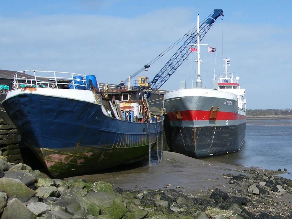
difficult to stand upright in exposed places! We began in Glasson — still a busy port these
days, though small. We were not allowed
into the docks, and we couldn’t see Bazil Point or Ferry Cottage on the other
side of the River Lune because there was a ship in the way. We bought delicious pasties at the village
shop, and managed to find a bench in a relatively sheltered place on which to
sit and eat them while they were still hot.
We were lucky enough to do this entire Walk in
sunshine, though we could have done with less wind which was so strong it was
difficult to stand upright in exposed places! We began in Glasson — still a busy port these
days, though small. We were not allowed
into the docks, and we couldn’t see Bazil Point or Ferry Cottage on the other
side of the River Lune because there was a ship in the way. We bought delicious pasties at the village
shop, and managed to find a bench in a relatively sheltered place on which to
sit and eat them while they were still hot.

 We started the Walk on the bridge over the Lancaster Canal.
We climbed a short hill, the only hill on today’s Walk, from the top of which
there were far-reaching views. To the
north we could see Bazil Point and Ferry Cottage where we were in the rain at
the end of the last Walk.
We started the Walk on the bridge over the Lancaster Canal.
We climbed a short hill, the only hill on today’s Walk, from the top of which
there were far-reaching views. To the
north we could see Bazil Point and Ferry Cottage where we were in the rain at
the end of the last Walk.
 To the east we
could see Lancaster
University where our son,
Paul, did his first degree — he got a ‘First’ in Chemistry when he was only
20. (Four years later he gained a PhD at
Leeds.)
Help! It is 22 years since Paul
was in his last term at Lancaster
— can we really be that old? At the beginning of that final year, he and
his caving/climbing friends abseiled down the tower block in the middle of the
university complex to show off to the ‘Freshers’. (Sssh! They also went sewer-lunking underneath the
University buildings, but don’t tell anyone because they were not supposed to
be there!)
To the east we
could see Lancaster
University where our son,
Paul, did his first degree — he got a ‘First’ in Chemistry when he was only
20. (Four years later he gained a PhD at
Leeds.)
Help! It is 22 years since Paul
was in his last term at Lancaster
— can we really be that old? At the beginning of that final year, he and
his caving/climbing friends abseiled down the tower block in the middle of the
university complex to show off to the ‘Freshers’. (Sssh! They also went sewer-lunking underneath the
University buildings, but don’t tell anyone because they were not supposed to
be there!)
 We passed some celandines on a bank as we descended —
we always look out for these bright cheery flowers as a harbinger of Spring,
which is very late this year. We crossed
several fields to a farm on the coast where there was a ram’s head on the wall
above the door.
We passed some celandines on a bank as we descended —
we always look out for these bright cheery flowers as a harbinger of Spring,
which is very late this year. We crossed
several fields to a farm on the coast where there was a ram’s head on the wall
above the door.
One footpath signpost
had an extra notice warning us there were free range children and animals about,
so please drive slowly. Another footpath
signpost was sited next to what looked like a bomb from the Second World War.
 The coast path was well signposted and mostly
tarmac. Visibility was very good — we
could clearly see Sunderland Point, where Sambo’s grave is sited, and Heysham
nuclear power station behind us. A
notice on the edge of the marsh told us of local concern about plans to leave
the sea defences to the mercies of the ocean, eventually abandoning the whole
area — including houses, caravan sites, agricultural land and the ruins of
Cockersands Abbey — to the waves. The
notice was dated 2010 — three years ago!
Yet it didn’t look as if the sea had encroached even the marshland in
front of us, let alone the fields behind.
Another notice warned us that “armed trespassers will be prosecuted” and
informed us that shooting is prohibited in Lancs on Christmas Day. It’s useful to know these things.
The coast path was well signposted and mostly
tarmac. Visibility was very good — we
could clearly see Sunderland Point, where Sambo’s grave is sited, and Heysham
nuclear power station behind us. A
notice on the edge of the marsh told us of local concern about plans to leave
the sea defences to the mercies of the ocean, eventually abandoning the whole
area — including houses, caravan sites, agricultural land and the ruins of
Cockersands Abbey — to the waves. The
notice was dated 2010 — three years ago!
Yet it didn’t look as if the sea had encroached even the marshland in
front of us, let alone the fields behind.
Another notice warned us that “armed trespassers will be prosecuted” and
informed us that shooting is prohibited in Lancs on Christmas Day. It’s useful to know these things.
 In the background to all our views stood Plover Scar
Lighthouse, a small lighthouse at the mouth of the River Lune placed there in
1847 to guide ships safely into the river channel. It is automatic now, of course, as they all
are. The path turned into grass but it
was solid, even and quite pleasant to walk on.
In the background to all our views stood Plover Scar
Lighthouse, a small lighthouse at the mouth of the River Lune placed there in
1847 to guide ships safely into the river channel. It is automatic now, of course, as they all
are. The path turned into grass but it
was solid, even and quite pleasant to walk on.
 Round a bend we came across the sparse remains of
Cockersands Abbey. This began as a
hermitage in the 12th century by Hugh Garth a ‘hermit of great
perfection’. Within a few years it was
taken over by monks of the Premonstratension Order (never heard of them) who built the abbey. From what we could work out from the plan on
the door of the one remaining building, most of the area on which the abbey was
built is now in the sea. It was surrendered
to the King’s Commissioners at the Reformation and left to go to ruin. Only the semi-octagonal chapter house remains
because it was used by the Dalton
family of Thurnham Hall as a burial place.
We couldn’t get inside it.
Round a bend we came across the sparse remains of
Cockersands Abbey. This began as a
hermitage in the 12th century by Hugh Garth a ‘hermit of great
perfection’. Within a few years it was
taken over by monks of the Premonstratension Order (never heard of them) who built the abbey. From what we could work out from the plan on
the door of the one remaining building, most of the area on which the abbey was
built is now in the sea. It was surrendered
to the King’s Commissioners at the Reformation and left to go to ruin. Only the semi-octagonal chapter house remains
because it was used by the Dalton
family of Thurnham Hall as a burial place.
We couldn’t get inside it.
 It was very windy there, and cold despite the
sun. So we moved on quickly round the
next bend. There we found an old barn
where we could sit on the windowsill out of the wind and eat our sarnies. We carried on past several caravan sites and
a lot of marshes. There were loads of sheep
about, and occasionally we found we were unintentionally ‘herding’ them. It reminded us of when we walked round the
seemingly endless Essex marshes near the
beginning of this Trek — Golly! that was ten
years ago!
It was very windy there, and cold despite the
sun. So we moved on quickly round the
next bend. There we found an old barn
where we could sit on the windowsill out of the wind and eat our sarnies. We carried on past several caravan sites and
a lot of marshes. There were loads of sheep
about, and occasionally we found we were unintentionally ‘herding’ them. It reminded us of when we walked round the
seemingly endless Essex marshes near the
beginning of this Trek — Golly! that was ten
years ago!
 We were feeling tired by then, the wind didn’t help
with our walking. We wore our kags just
to keep warm, they made good windshields.
Eventually the path took us along the bottom of a bank to the road. There we sat on some wood to rest, drink some
water and don our high-viz waistcoats. We
had three miles of road-walking to do, and it was deadly! We stopped on a bridge about halfway for
another rest. Colin went off at a
tangent to change his pad, but it was difficult to find somewhere out of sight because
the whole area was open. In the end he
crouched behind a wall — keeping his dignity is very difficult for him at the
moment.
We were feeling tired by then, the wind didn’t help
with our walking. We wore our kags just
to keep warm, they made good windshields.
Eventually the path took us along the bottom of a bank to the road. There we sat on some wood to rest, drink some
water and don our high-viz waistcoats. We
had three miles of road-walking to do, and it was deadly! We stopped on a bridge about halfway for
another rest. Colin went off at a
tangent to change his pad, but it was difficult to find somewhere out of sight because
the whole area was open. In the end he
crouched behind a wall — keeping his dignity is very difficult for him at the
moment.
 At last we were able to turn off on to a minor road,
and after a few yards we came to a car park.
A path led us through trees to a lovely picnic area sheltered from the
wind and decorated with daffodils all round.
Some colourful chickens wandered past, pecking at the ground, while we
sat there and ate our chocolate. It was
lovely to relax a bit in such a pleasant spot, well away from the traffic after
that dreadful three-mile road stomp.
At last we were able to turn off on to a minor road,
and after a few yards we came to a car park.
A path led us through trees to a lovely picnic area sheltered from the
wind and decorated with daffodils all round.
Some colourful chickens wandered past, pecking at the ground, while we
sat there and ate our chocolate. It was
lovely to relax a bit in such a pleasant spot, well away from the traffic after
that dreadful three-mile road stomp.
Our map told us that the Coastal Way took us for the next couple of miles along the minor road through the village of Pilling. But we noticed that there was a stile up on the sea bank by the picnic site. A notice attached to the stile told us that there was no public access between 26th December and Good Friday. It didn’t explain why, so I looked it up on the internet — apparently it is to protect over-wintering birds and livestock during the nesting and lambing season. I also found out that the embankment was built in 1981 to protect the village of Pilling which had been prone to flooding up until then.
 Well, Easter was early this year, and Good Friday
had long since past. It was lovely
walking up there — a wide, firm, grassy path, and it was a short cut, off the
road missing out Pilling altogether. On
the second stile we passed were Coastal
Way stickers — now
they tell us, for there had been none on the first. We passed several gates along the length of
the sea bank, all of which we could walk round — we didn’t even have to open
them.
Well, Easter was early this year, and Good Friday
had long since past. It was lovely
walking up there — a wide, firm, grassy path, and it was a short cut, off the
road missing out Pilling altogether. On
the second stile we passed were Coastal
Way stickers — now
they tell us, for there had been none on the first. We passed several gates along the length of
the sea bank, all of which we could walk round — we didn’t even have to open
them.

 We had an excellent view of Lancaster University
from there, better than the view we had further back. As we by-passed the village we could see
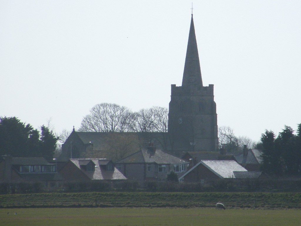
Pilling church, and an old fashioned windmill which was minus its sails.
We had an excellent view of Lancaster University
from there, better than the view we had further back. As we by-passed the village we could see
Pilling church, and an old fashioned windmill which was minus its sails.
 I was ahead of Colin, and didn’t notice that at one
of the gates the Coastal Way
path was signposted to go down the landward side of the bank and across some
fields to the road. I carried on along
the top of the bank, lost in my own dream world.
I was ahead of Colin, and didn’t notice that at one
of the gates the Coastal Way
path was signposted to go down the landward side of the bank and across some
fields to the road. I carried on along
the top of the bank, lost in my own dream world.
 Colin caught me up just as I reached a barbed
wire fence barring my way, and explained where I had gone wrong. We were both reluctant to go back, we
couldn’t see why we were not permitted to go the last quarter of a mile on the
bank. What possible harm could we do
walking along there? It looked as though
people before us had gone down the seaward side on to the marsh — they had worn
a bit of a path. But the barbed wire
fence continued across the marsh all the way to a deep ditch. Looking more closely, we realised that our
predecessors had stepped through the fence at a point where the wires were
loose. So we did the same, holding the
strands apart for each other. I was a
little apprehensive about not being able to get through at the further end of
the sea bank, but when we saw people out playing with their children and walking
their dogs on the marsh next to us we realised that the barbed wire fence had
been put there to stop people walking towards Glasson, not away from it like we
were. Why? Why not open it all up
and make life simpler? So there was no
‘other end’ to cause a problem.
Colin caught me up just as I reached a barbed
wire fence barring my way, and explained where I had gone wrong. We were both reluctant to go back, we
couldn’t see why we were not permitted to go the last quarter of a mile on the
bank. What possible harm could we do
walking along there? It looked as though
people before us had gone down the seaward side on to the marsh — they had worn
a bit of a path. But the barbed wire
fence continued across the marsh all the way to a deep ditch. Looking more closely, we realised that our
predecessors had stepped through the fence at a point where the wires were
loose. So we did the same, holding the
strands apart for each other. I was a
little apprehensive about not being able to get through at the further end of
the sea bank, but when we saw people out playing with their children and walking
their dogs on the marsh next to us we realised that the barbed wire fence had
been put there to stop people walking towards Glasson, not away from it like we
were. Why? Why not open it all up
and make life simpler? So there was no
‘other end’ to cause a problem.
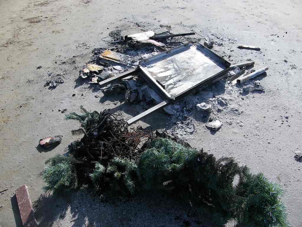
 The marsh gradually became sandier. We sat on a rock to eat our apples. Nearby was the remains of a fire on which
someone had tried unsuccessfully to burn a painting easel and a Christmas
tree. We came to a car park, and since
the beach was getting rockier by the minute we went up there to walk on the
official coastal path which was tarmacked from that point all the way to the
end of the Walk. The trouble was — we
were walking due west into the setting sun which was very bright. We could barely see where we were going, and
it was terrible light for photography.
The marsh gradually became sandier. We sat on a rock to eat our apples. Nearby was the remains of a fire on which
someone had tried unsuccessfully to burn a painting easel and a Christmas
tree. We came to a car park, and since
the beach was getting rockier by the minute we went up there to walk on the
official coastal path which was tarmacked from that point all the way to the
end of the Walk. The trouble was — we
were walking due west into the setting sun which was very bright. We could barely see where we were going, and
it was terrible light for photography.
 To our right was a rocky marshy beach, not good for
walking, further out it looked as if it could be muddy.
To our right was a rocky marshy beach, not good for
walking, further out it looked as if it could be muddy.

 People’s back gardens were down on our left,
protected from stormy seas by the sea bank on which we were walking. We passed a garden where chickens were kept,
and among them was an ostrich-type bird, we think it was a cassowary. It looked quite superior, as if it was ruling
the chickens.
People’s back gardens were down on our left,
protected from stormy seas by the sea bank on which we were walking. We passed a garden where chickens were kept,
and among them was an ostrich-type bird, we think it was a cassowary. It looked quite superior, as if it was ruling
the chickens.
 Another garden was
festooned with forsythia bushes in brilliant flower — Spring is here at last!
Another garden was
festooned with forsythia bushes in brilliant flower — Spring is here at last!

 Out on the sands we saw horses running, perhaps it
wasn’t that muddy after all. We also
passed some children playing on the marsh — not much of a beach for them, but
they seemed to be enjoying themselves as children do.
Out on the sands we saw horses running, perhaps it
wasn’t that muddy after all. We also
passed some children playing on the marsh — not much of a beach for them, but
they seemed to be enjoying themselves as children do.

 We walked through Knott End-on –Sea, where our car
was parked, and eventually came to the ferry slipway. The last ferry of the day across the River
Wyre had already left, we could see it approaching Fleet wood on the other
side. But we had no intention of
catching it because the logistics of using the ferry were too great. As usual, we pretended instead. We walked out to the end of the slipway, and
the ferry seemed to turn round as if it was coming back for us. So we turned round and exited the slipway as
fast as we could so that they didn’t have a wasted journey.
We walked through Knott End-on –Sea, where our car
was parked, and eventually came to the ferry slipway. The last ferry of the day across the River
Wyre had already left, we could see it approaching Fleet wood on the other
side. But we had no intention of
catching it because the logistics of using the ferry were too great. As usual, we pretended instead. We walked out to the end of the slipway, and
the ferry seemed to turn round as if it was coming back for us. So we turned round and exited the slipway as
fast as we could so that they didn’t have a wasted journey.

That ended Walk no.319, we shall pick up Walk no.320 in Fleetwood over the River Wyre. It was six o’clock, so the Walk had taken us seven hours, five minutes. Our car was parked nearby. After partaking of tea and chocolate biscuits, we drove back to our caravan in Blackpool.
Location: Glasson to Fleetwood.
Distance: 14 miles.
Total distance: 3273 miles.
Terrain: Lots of concrete. Lots of tracks (but none muddy!) Lovely sea-bank. One barbed wire fence. Nearly all flat.
Tide: Out, coming in.
Rivers: No.395, River Wyre.
Ferries: No.23 across the Wyre from Knott End-on-Sea to Fleetwood. Fare £1.50 each.
Piers: None.
Kissing gates: Nos. 404, 405 & 406 between Glasson and Cockerham.
Pubs: None.
‘English Heritage’ properties: None.
Ferris wheels: None.
Diversions: None.
How we got there and back: We were staying in our caravan in Blackpool. This morning we drove to Knott End-on-Sea, parked near the ferry terminal and caught a bus to Glasson.
At the end we finished the Walk at Knott-End-on-Sea at the ferry terminal — we pretended the ferry over to Fleetwood. Our car was parked nearby. After partaking of tea and chocolate biscuits, we drove back to our caravan in Blackpool.


Our map told us that the Coastal Way took us for the next couple of miles along the minor road through the village of Pilling. But we noticed that there was a stile up on the sea bank by the picnic site. A notice attached to the stile told us that there was no public access between 26th December and Good Friday. It didn’t explain why, so I looked it up on the internet — apparently it is to protect over-wintering birds and livestock during the nesting and lambing season. I also found out that the embankment was built in 1981 to protect the village of Pilling which had been prone to flooding up until then.


That ended Walk no.319, we shall pick up Walk no.320 in Fleetwood over the River Wyre. It was six o’clock, so the Walk had taken us seven hours, five minutes. Our car was parked nearby. After partaking of tea and chocolate biscuits, we drove back to our caravan in Blackpool.

No comments:
Post a Comment