Weather: Another day of brilliant sunshine, but a cold
wind.
Location: Hell’s Mouth to Abersoch.
Distance: 10 miles.
Total
distance: 3663 miles.
Terrain: Quite a bit of beach. Mostly grassy paths on top of soft
cliffs. Fairly undulating.
Tide: Going out.
Rivers: None.
Ferries: None.
Piers: None.
Kissing gates: Nos.739 to 747 (9), mostly bunched in the
middle of the Walk.
Pubs: None.
‘Cadw’ properties: None.
Ferris wheels: None.
Diversions: None.
 There was a cold wind, so Colin dressed up in a coat, kag
with hood, gloves, and then he put a sunhat on top! (He did
look a bit ridiculous) I decided
that if I walked quickly enough I would get warm — and so it was. We set off to walk the last mile of this
beautiful beach. The tide was in, so we
had to walk on the loose sand at the top of the beach, which was a little
awkward but not unduly so. We sat on
hardened mud rocks to eat our pasties — delicious!
— bought this morning from a butcher’s in Abersoch.
There was a cold wind, so Colin dressed up in a coat, kag
with hood, gloves, and then he put a sunhat on top! (He did
look a bit ridiculous) I decided
that if I walked quickly enough I would get warm — and so it was. We set off to walk the last mile of this
beautiful beach. The tide was in, so we
had to walk on the loose sand at the top of the beach, which was a little
awkward but not unduly so. We sat on
hardened mud rocks to eat our pasties — delicious!
— bought this morning from a butcher’s in Abersoch.

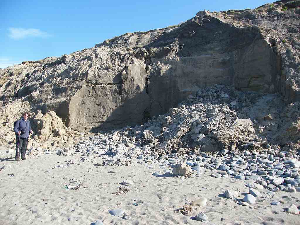
 We carried on. We came
across a large jellyfish stranded above high water mark. We also passed a recent cliff collapse — the
sand the cliffs are made of is very soft.
They are low at this end of the beach — only six foot or so and not
exactly vertical — so we easily climbed up when the sand ran out. We went up through a field on a curvy path as
shown on the map.
We carried on. We came
across a large jellyfish stranded above high water mark. We also passed a recent cliff collapse — the
sand the cliffs are made of is very soft.
They are low at this end of the beach — only six foot or so and not
exactly vertical — so we easily climbed up when the sand ran out. We went up through a field on a curvy path as
shown on the map.
 It was not until we had trudged all the way up there that
Colin noticed he was no longer wearing his sunhat. I hadn’t actually taken any notice of it
since we had started the Walk, and of course he couldn’t feel it through his
hood so he didn’t notice when it inevitably blew off in the wind. He only
wanted to go back to the beach to look for it! I persuaded him that he must have lost it
before we sat and ate our pasties, that he’d never find it, and he shouldn’t
have been so stupid as to wear it on the outside of his hood in the first
place! We carried on — is he in the first stages of dementia? Aren’t we all?
It was not until we had trudged all the way up there that
Colin noticed he was no longer wearing his sunhat. I hadn’t actually taken any notice of it
since we had started the Walk, and of course he couldn’t feel it through his
hood so he didn’t notice when it inevitably blew off in the wind. He only
wanted to go back to the beach to look for it! I persuaded him that he must have lost it
before we sat and ate our pasties, that he’d never find it, and he shouldn’t
have been so stupid as to wear it on the outside of his hood in the first
place! We carried on — is he in the first stages of dementia? Aren’t we all?

 We were now in an area of open access which took us all round
the headland, the southernmost point of the Lleyn peninsula. We followed a good path across open moorland
— it was lovely up there in brilliant sunshine looking out across the sea. We thought we were alone in the world, but we
were caught up by two friendly sheepdogs.
Looking back, we could see an elderly shepherd in a Landrover with
another sheepdog. He drove very slowly
past us and continued on — we didn’t see him stop and look at any sheep along
the way.
We were now in an area of open access which took us all round
the headland, the southernmost point of the Lleyn peninsula. We followed a good path across open moorland
— it was lovely up there in brilliant sunshine looking out across the sea. We thought we were alone in the world, but we
were caught up by two friendly sheepdogs.
Looking back, we could see an elderly shepherd in a Landrover with
another sheepdog. He drove very slowly
past us and continued on — we didn’t see him stop and look at any sheep along
the way.

 When we got to the end of the open access area, we sat on a
rock to eat our sandwiches and apples. We
heard voices behind us coming from the other side of a locked gate. A man, together with his mother and teenage
son had got lost trying to follow the Coastal Path in the opposite
direction. They said the signs, when
they existed, were ambiguous. “Mother”
couldn’t climb the gate they were stuck behind, so they had to turn back to the
previous gate which they were relieved to find was unlocked. They were complaining that the Coast Path
signage was poor — and they had bought the guidebook,
When we got to the end of the open access area, we sat on a
rock to eat our sandwiches and apples. We
heard voices behind us coming from the other side of a locked gate. A man, together with his mother and teenage
son had got lost trying to follow the Coastal Path in the opposite
direction. They said the signs, when
they existed, were ambiguous. “Mother”
couldn’t climb the gate they were stuck behind, so they had to turn back to the
previous gate which they were relieved to find was unlocked. They were complaining that the Coast Path
signage was poor — and they had bought the guidebook,
which was more than we
had!

 We continued downhill on the outside of the fence, a sign
told us that this was a permissive path.
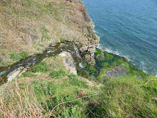
There were celandines and violets all over the place — very pretty. We came to a little waterfall trickling down
the cliff, and there the path took us up and away from the coast. There was a plethora of arrows on a kissing
gate we came to, we couldn’t work out which way we were supposed to go.
We continued downhill on the outside of the fence, a sign
told us that this was a permissive path.
There were celandines and violets all over the place — very pretty. We came to a little waterfall trickling down
the cliff, and there the path took us up and away from the coast. There was a plethora of arrows on a kissing
gate we came to, we couldn’t work out which way we were supposed to go.
 After much debate we decided they meant us to
stay outside the field — but this turned out to be an animal path. While Colin was watering a bush, I untied
barbed wire round a gatepost and opened the gate. Colin tied it up again when he came up. We walked across several fields and out into
a lane.
After much debate we decided they meant us to
stay outside the field — but this turned out to be an animal path. While Colin was watering a bush, I untied
barbed wire round a gatepost and opened the gate. Colin tied it up again when he came up. We walked across several fields and out into
a lane.
 We passed a man painting his cottage and garden wall a
brilliant white which was almost blinding in the sun. We also passed a derelict Methodist chapel,
and a rather snazzy witch weathervane. About
half a mile down the lane we were supposed to turn off across fields, according
to our map. But there were still no
Coast Path signs! We climbed over the
stile anyway, and walked across several fields.
Then we hooked back to the lane.
Further down there, at last, we came across Coast Path signs again. We had walked a couple of miles without
seeing any signs — no wonder those people we met further back got lost!
We passed a man painting his cottage and garden wall a
brilliant white which was almost blinding in the sun. We also passed a derelict Methodist chapel,
and a rather snazzy witch weathervane. About
half a mile down the lane we were supposed to turn off across fields, according
to our map. But there were still no
Coast Path signs! We climbed over the
stile anyway, and walked across several fields.
Then we hooked back to the lane.
Further down there, at last, we came across Coast Path signs again. We had walked a couple of miles without
seeing any signs — no wonder those people we met further back got lost!

 The lane turned into a grassy track which took us all the way
down to the top of a lovely sandy beach.
There was gorgeous blackthorn blossom all the way down, and we passed
some interesting geology too as the path cut through some rocks.
The lane turned into a grassy track which took us all the way
down to the top of a lovely sandy beach.
There was gorgeous blackthorn blossom all the way down, and we passed
some interesting geology too as the path cut through some rocks.
 There were quite a few people about from
hereon, we were no longer alone. There
was only one way down to the beach, so we didn’t go down because we would have
had to come back up the same way.
There were quite a few people about from
hereon, we were no longer alone. There
was only one way down to the beach, so we didn’t go down because we would have
had to come back up the same way.
 We went through a gate with a sign warning us about breeding
bulls in that field (Help!) We were delighted to
discover that the official Coast Path now goes all round the next headland,
whereas our fairly new OS map shows an inland path only. (I
won’t rant on about spending oodles of our hard-earned on out-of-date OS maps
because I have done that too many times in this journal already!)
We went through a gate with a sign warning us about breeding
bulls in that field (Help!) We were delighted to
discover that the official Coast Path now goes all round the next headland,
whereas our fairly new OS map shows an inland path only. (I
won’t rant on about spending oodles of our hard-earned on out-of-date OS maps
because I have done that too many times in this journal already!)
 We climbed slowly to the top of the cliff and along the
outside of a fence. As we rounded the
corner we got good views of St Tudwal’s Islands
with a lighthouse on the nearer one. We
wondered what had killed the grass we were walking over, it was all grey. We went down to a spring where there was a
gate on a bridge. It was difficult to
open, but Colin is strong! Then we had
to go up again (grooh!) and all the
way round the headland. I was pleased to
be able to do it, but it made the Walk longer and I was very tired by
then. (I can’t do it like I used to!)
At last we turned a corner and could see Abersoch ahead.
We climbed slowly to the top of the cliff and along the
outside of a fence. As we rounded the
corner we got good views of St Tudwal’s Islands
with a lighthouse on the nearer one. We
wondered what had killed the grass we were walking over, it was all grey. We went down to a spring where there was a
gate on a bridge. It was difficult to
open, but Colin is strong! Then we had
to go up again (grooh!) and all the
way round the headland. I was pleased to
be able to do it, but it made the Walk longer and I was very tired by
then. (I can’t do it like I used to!)
At last we turned a corner and could see Abersoch ahead.
 There was a kind of chimney on top, and we wondered if it had
anything to do with mining. We came down
a steep path, and there was a ruined minetop building. A sign told us to put our smartphone on a tab
to learn all about the old mine — but we haven’t got a smartphone so we
couldn’t.
There was a kind of chimney on top, and we wondered if it had
anything to do with mining. We came down
a steep path, and there was a ruined minetop building. A sign told us to put our smartphone on a tab
to learn all about the old mine — but we haven’t got a smartphone so we
couldn’t.
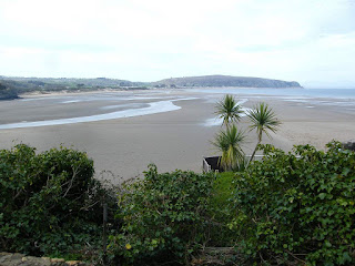
We emerged on to a gravel lane. There was a “Road Closed” notice on the path we wanted to take down to the beach, but we ignored it and went anyway. It turned out to be walkable — just. Mostly it had been washed away in channels, but we were able to walk on the ridges in between. At the bottom the stream came out of a pipe and over concrete to the beach. Colin noticed that there were steps on the side of the concrete, so we used them to struggle carefully down to the beach.
 Fortunately the tide was out — the beach would have been
completely covered if it had been in. We
sat on a rock to eat our chocolate before continuing. We took a huge shortcut across the corner
because the tide was right out and the sand was firm. We came, at last, to the Golf Club road where
there were numerous people on the beach and lots of beach huts. We nipped up the road to use the loos in the
car park, then came back to the beach to buy ice creams. We sat on the chairs provided to eat them and
people-watch — it made a pleasant interlude.
Fortunately the tide was out — the beach would have been
completely covered if it had been in. We
sat on a rock to eat our chocolate before continuing. We took a huge shortcut across the corner
because the tide was right out and the sand was firm. We came, at last, to the Golf Club road where
there were numerous people on the beach and lots of beach huts. We nipped up the road to use the loos in the
car park, then came back to the beach to buy ice creams. We sat on the chairs provided to eat them and
people-watch — it made a pleasant interlude.
 When we felt rested a little, we continued along the
beach. We watched children ‘surfing’ on
the loose sand. Some of them were doing
quite spectacular jumps, but none of them seemed to hurt themselves. We walked to the end of the beach where we
saw tiers and tiers of, what looked like, Victorian changing rooms.
When we felt rested a little, we continued along the
beach. We watched children ‘surfing’ on
the loose sand. Some of them were doing
quite spectacular jumps, but none of them seemed to hurt themselves. We walked to the end of the beach where we
saw tiers and tiers of, what looked like, Victorian changing rooms.

 Just
before we reached them, we left the beach and went up a road. We turned right
into a private road — this turned into a path, then steps.
Just
before we reached them, we left the beach and went up a road. We turned right
into a private road — this turned into a path, then steps.
 We walked down the road to where our car was parked.

How
we got there and back: We were staying
in our caravan in Snowdonia. This
morning we drove to Abersoch, parked by a roadside, and caught a bus to
Llangenan. From there we walked a mile
down the road to Hell’s Mouth
Beach.
At the end we came upon our car parked in Abersoch. We had our tea and biscuits, then returned to our caravan.
At the end we came upon our car parked in Abersoch. We had our tea and biscuits, then returned to our caravan.
A couple of days
later we returned home to Malvern.


There were no Coastal Path signs where we were, and the track
seemed to peter out. Also, Colin noticed
that we were on top of the cliffs whereas we should have been several fields inland
at that point. So, with great difficulty
(because of my back problem), I climbed over a stile to go further inland. Then Colin decided we should continue along
the clifftop and meet the path further up.
So, with great difficulty, I climbed back over the self-same stile! (I
wasn’t best pleased, to say the least!)
The first gate we came to wasn’t locked, but tied up in knots with
twine. Colin managed to undo them and
open the gate. (I calmed down a little.) The
next gate was open, but we were forced into a field and had to turn inland
after all. Fortunately the gate at the
far end opened easily and we were once more on the Coastal Path. (Phew!)


We emerged on to a gravel lane. There was a “Road Closed” notice on the path we wanted to take down to the beach, but we ignored it and went anyway. It turned out to be walkable — just. Mostly it had been washed away in channels, but we were able to walk on the ridges in between. At the bottom the stream came out of a pipe and over concrete to the beach. Colin noticed that there were steps on the side of the concrete, so we used them to struggle carefully down to the beach.


We passed a house where the first-floor balcony was bent at a
weird angle. We wondered how it had got
like that, it looked as if something very heavy had hit it. We came out on to a road past the house and
looked back at it. The roof was caved in
that side, and a newly sawn off tree stump was behind it! There were people in the garden burning wood. We hope no one was hurt when that tree fell
down — it had certainly done a lot of damage to the house.


That ended Walk no.355, we shall pick up Walk no.356 next time in
Abersoch. It was five to five, so the
Walk had taken us seven hours, forty minutes.
We had our tea and biscuits, then returned to our caravan.
A couple of days later we returned home to Malvern.

No comments:
Post a Comment