Ages: Colin was 72 years and 69 days. Rosemary was 69 years and 211 days.
Weather: Wet and windy until 3pm. Then it suddenly turned hot and sunny. Breezy.
Location: Pwllheli to Criccieth.
Distance: 12 miles.
Total
distance: 3684 miles.
Terrain: A lot of beach, then cliff paths. A main road with a wide pavement. Across fields and marsh at the end. Mostly flat.
Tide: In, going out.
Rivers: No.431, Afon Rhid-hir in Pwllheli. No.432, Afon Dwyfach on the road. No.433, Afon Dwyfor at Llanystumdwy.
Ferries: None.
Piers: None.
Kissing gates: Nos.748 & 749 on Pen-ychain
headland. Nos.750, 751, 752 & 753 as
we approached Criccieth.
Pubs: None.
‘Cadw’ properties: No.8, Penarth Fawr. No.9, Criccieth Castle.
Ferris wheels: None.
Diversions: None.
How we got there and back: We were staying in our caravan in Snowdonia. This morning we drove to Criccieth where we parked by the waterfront. We walked to the village centre and caught a bus to Pwllheli.
At the end we came upon our car parked in Criccieth. We had our tea and biscuits, then returned to our caravan.

 We started today’s Walk at the War Memorial in Pwllheli. As we walked round the harbour we were
appalled to discover that it would have cost £7.50 to park on the north side of
the harbour last Monday whereas it was free to park on the west side where we
did! We thought the rain had stopped,
but it soon started again. We sat in a
shelter to eat our pie/croissant and put on our wet-weather gear.
We started today’s Walk at the War Memorial in Pwllheli. As we walked round the harbour we were
appalled to discover that it would have cost £7.50 to park on the north side of
the harbour last Monday whereas it was free to park on the west side where we
did! We thought the rain had stopped,
but it soon started again. We sat in a
shelter to eat our pie/croissant and put on our wet-weather gear.
 The marina down the east side of the harbour was mostly a
construction site, so we had to stick to the road.
The marina down the east side of the harbour was mostly a
construction site, so we had to stick to the road.
 We came to the end and thought we had boobed
because the tide was in, but the path did continue along the top of the
beach. At the beginning the path was
overgrown with bushes, but we did manage to walk round them. We were protected from the wind at first, but
photography was restricted because of the poor visibility.
We came to the end and thought we had boobed
because the tide was in, but the path did continue along the top of the
beach. At the beginning the path was
overgrown with bushes, but we did manage to walk round them. We were protected from the wind at first, but
photography was restricted because of the poor visibility.
 There were some unusual and very pretty
flowers on that part of the beach, we didn’t know what they were. They looked more like garden flowers than
wild ones.
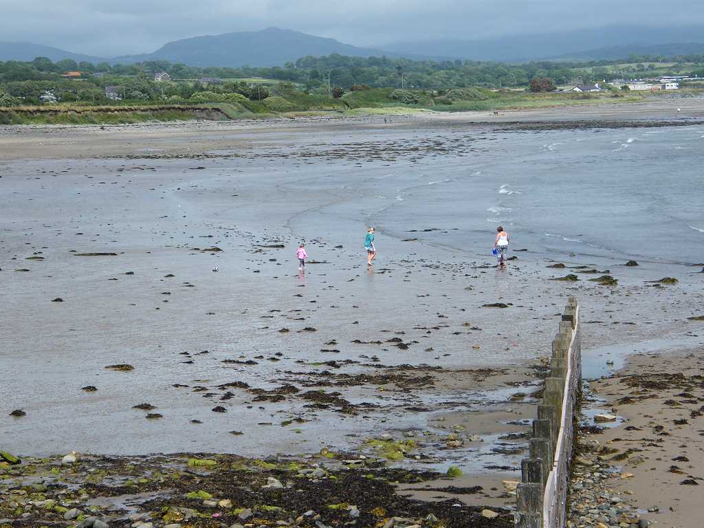
We walked for miles along the sandy beach with rolling surf
to our right and dunes to our left.
There were some unusual and very pretty
flowers on that part of the beach, we didn’t know what they were. They looked more like garden flowers than
wild ones.
We walked for miles along the sandy beach with rolling surf
to our right and dunes to our left.

 We quite
enjoyed it at first despite the rain because the wind was on our backs. But as the rain intensified and we walked
round the crescent with the wind more to our right, it became a bit of a
slog. We came to a “Road Works” notice
on the beach! It was surrounded by dire
warnings that this was a “hard hat” area and we must not enter the “site”, etc,
etc. We ignored them all and carried on. There was nothing on the beach itself, except
sand. Some diggers were up on the dunes
trying to hold them together and planting, we thought. But nobody was working there in this weather.
We quite
enjoyed it at first despite the rain because the wind was on our backs. But as the rain intensified and we walked
round the crescent with the wind more to our right, it became a bit of a
slog. We came to a “Road Works” notice
on the beach! It was surrounded by dire
warnings that this was a “hard hat” area and we must not enter the “site”, etc,
etc. We ignored them all and carried on. There was nothing on the beach itself, except
sand. Some diggers were up on the dunes
trying to hold them together and planting, we thought. But nobody was working there in this weather.
We saw a holiday chalet overhanging the edge of the soft sandy cliff, and it reminded us of the erosion we saw on the east coast, particularly around Mundesley in Norfolk. We came to some rocks under a bit of overhanging cliff where it was less wet and windy. So I sat down to eat my sarnies (perhaps a bit foolish, in retrospect). Colin marched off “to look for a better place”, but having tried three different spots he came back and grumpily sat down beside me. It reminded me of that hilarious play “East of Ipswich” – I think Michael Palin wrote it – which was on television yonks ago. (I do wish they would repeat it.)
 We marched on doggedly as the wind and rain intensified. (It’s
on days like this that we wonder why we’re doing this.) It was hard going, really miserable now. We saw some cormorants on the beach ahead —
even they didn’t look as if they were enjoying themselves!
We marched on doggedly as the wind and rain intensified. (It’s
on days like this that we wonder why we’re doing this.) It was hard going, really miserable now. We saw some cormorants on the beach ahead —
even they didn’t look as if they were enjoying themselves!
 Towards the end of the beach it turned stony,
but it wasn’t too bad to walk on. We
stayed next to the dunes because an occasional path looped through the edge of
them away from the shingle.
Towards the end of the beach it turned stony,
but it wasn’t too bad to walk on. We
stayed next to the dunes because an occasional path looped through the edge of
them away from the shingle.
Colin started walking up a ghost of a path leading to the top of the dunes. Three times I asked him if it was a decent path, because it didn’t look as if it was, but he wouldn’t answer me — wet and windy weather always puts him in a bad mood. He was determined to follow it, so I followed him. I shouldn’t have. The ‘path’ deteriorated at the top, I caught my foot in a loopy root and fell headlong! I wasn’t hurt, but I was a bit shocked. I fell downhill so my feet ended up higher than my head. I had great difficulty getting up, I even had dirt on my face. A man came rushing up from the beach — the first person we had seen since Pwllheli — because he had seen me fall but I assured him I was OK. He asked, “Is that a better path?” and Colin answered, “Don’t know, we’ve not been here before!” He said, “I’m going the beach way!” and disappeared downhill, later joining his friends at the gate leading on to the headland. I wanted to return to the beach, but Colin was still determined to carry on even though the ‘path’ had completely disappeared. Sometimes the ferns were over our heads! We got to the gate eventually.
 By then the rain had stopped — just — but it was still pretty
windy. We were both soaked — our
wet-weather gear is not as waterproof as it once was. There was a good path over the headland. We came across a gun emplacement at the end,
a legacy of the Second World War. The
sea was rough with the wind which hadn’t yet died down, waves were breaking
against the cliffs. We should have been
able to see Criccieth from the top, but the visibility was too poor.
By then the rain had stopped — just — but it was still pretty
windy. We were both soaked — our
wet-weather gear is not as waterproof as it once was. There was a good path over the headland. We came across a gun emplacement at the end,
a legacy of the Second World War. The
sea was rough with the wind which hadn’t yet died down, waves were breaking
against the cliffs. We should have been
able to see Criccieth from the top, but the visibility was too poor.
 The path improved the other side of the headland, it was more
gravel-based there. As we approached a
holiday village and descended to a beach area, we lost it. We came to an “exercise area” which seem to be springing up all over the country
in a bid to encourage people to change their lifestyles and stop being such
couch potatoes. We sat on some wooden
steps to eat our apples. I was all in
and would happily have given up there and then.
But then a small miracle happened — the wind died, the clouds cleared,
and suddenly it was a hot sunny day.
Such a contrast! I got my second
wind and was OK to carry on. Visibility
improved, and we could see across the water to Snowdonia very clearly now.
The path improved the other side of the headland, it was more
gravel-based there. As we approached a
holiday village and descended to a beach area, we lost it. We came to an “exercise area” which seem to be springing up all over the country
in a bid to encourage people to change their lifestyles and stop being such
couch potatoes. We sat on some wooden
steps to eat our apples. I was all in
and would happily have given up there and then.
But then a small miracle happened — the wind died, the clouds cleared,
and suddenly it was a hot sunny day.
Such a contrast! I got my second
wind and was OK to carry on. Visibility
improved, and we could see across the water to Snowdonia very clearly now.

 We met lots of people now, mostly holiday-makers who were
emerging from their static caravans and chalets as the sun came out. The holiday village stretched all the way to
the sewage works! And we passed the
first Wales Coast Path sign of the day — we have only walked five miles. We could have gone down on to the beach
there, where we could see an obese woman playing with her kids, but we didn’t
because we didn’t want to miss the place where the path turned inland. It was a nice path along the top anyway.
We met lots of people now, mostly holiday-makers who were
emerging from their static caravans and chalets as the sun came out. The holiday village stretched all the way to
the sewage works! And we passed the
first Wales Coast Path sign of the day — we have only walked five miles. We could have gone down on to the beach
there, where we could see an obese woman playing with her kids, but we didn’t
because we didn’t want to miss the place where the path turned inland. It was a nice path along the top anyway.
 Just before a swamp, the path turned away from the shore —
the place was clearly marked with a wooden signpost. We had to do this because there was a river
ahead with no footbridge over it, only a road bridge. We went under the railway, then up a quiet
road to a main road. After that it was a
slog for two and a half miles alongside the main road. But we did have a nice wide cycletrack to
walk on, so there was no traffic-dodging involved. About halfway we passed a caravan sales
outlet that sold ICE CREAMS! Fortified by a choc-ice each, we slogged
on. At last we crossed the river, and
immediately we were able to turn off the main road leaving all that noisy
smelly traffic behind.
Just before a swamp, the path turned away from the shore —
the place was clearly marked with a wooden signpost. We had to do this because there was a river
ahead with no footbridge over it, only a road bridge. We went under the railway, then up a quiet
road to a main road. After that it was a
slog for two and a half miles alongside the main road. But we did have a nice wide cycletrack to
walk on, so there was no traffic-dodging involved. About halfway we passed a caravan sales
outlet that sold ICE CREAMS! Fortified by a choc-ice each, we slogged
on. At last we crossed the river, and
immediately we were able to turn off the main road leaving all that noisy
smelly traffic behind.
We crossed fields and the railway, which was rusty because it hasn’t been used since the bridge at Penrhyndeudraeth was washed away last February. We came to the river again — we hadn’t followed its meanders — where it runs parallel to the coast. We met a number of other walkers going the other way on this stretch.

 It was a bit
boggy, but boardwalks had been put down over the worst bits. We sat on a wall to eat our chocolate. After half a mile we came to the river mouth,
so it would have been possible to get down on to the beach. But it was too stony to walk, so we stayed on
the good path along the top. Now we could see Criccieth Castle
ahead. Nearly there!
It was a bit
boggy, but boardwalks had been put down over the worst bits. We sat on a wall to eat our chocolate. After half a mile we came to the river mouth,
so it would have been possible to get down on to the beach. But it was too stony to walk, so we stayed on
the good path along the top. Now we could see Criccieth Castle
ahead. Nearly there!
 We passed a bird-watching couple — then they caught up with
us when we stopped to take photographs.
They asked, “Are you from
Malvern? You’re the couple walking the Wales Coast
Path, aren’t you?” They were Stuart
and Pat, members of the Malvern U3A Welsh Culture Group! They had recognised us, but we hadn’t
recognised them. (I am notoriously bad at
face-recognition). We had been
trying, but failing, to take an anniversary picture of us using the 10 second
delay timer on my camera, so we asked Stuart to take one of us, which he
did.
We passed a bird-watching couple — then they caught up with
us when we stopped to take photographs.
They asked, “Are you from
Malvern? You’re the couple walking the Wales Coast
Path, aren’t you?” They were Stuart
and Pat, members of the Malvern U3A Welsh Culture Group! They had recognised us, but we hadn’t
recognised them. (I am notoriously bad at
face-recognition). We had been
trying, but failing, to take an anniversary picture of us using the 10 second
delay timer on my camera, so we asked Stuart to take one of us, which he
did.
 They wished us luck with our
venture — Pat said they were only walking as far as their car which was parked
nearby.
They wished us luck with our
venture — Pat said they were only walking as far as their car which was parked
nearby.
 We didn’t have far to go — we walked into Criccieth where we
had to climb a bit of a hill to pass the castle on the inland side because the
tide was too far in and waves were bashing against the castle mound on the
shore side. Then it was downhill to East Beach
where our car was parked.
We didn’t have far to go — we walked into Criccieth where we
had to climb a bit of a hill to pass the castle on the inland side because the
tide was too far in and waves were bashing against the castle mound on the
shore side. Then it was downhill to East Beach
where our car was parked.
 That ended Walk no.357, we shall pick up Walk no.358 next time on East Beach
in Criccieth. It was twenty-five to
seven, so the Walk had taken us eight hours forty minutes. We had our tea and biscuits, then returned to
our caravan.
That ended Walk no.357, we shall pick up Walk no.358 next time on East Beach
in Criccieth. It was twenty-five to
seven, so the Walk had taken us eight hours forty minutes. We had our tea and biscuits, then returned to
our caravan.

 An imposing gatehouse! And that is more or less all that is left of Criccieth Castle.
It was built in 1230, long before the reign of Edward I, by Llywelyn
ap Gruffudd. When Edward I came
rampaging across Wales
in 1283, he captured this castle for the English. It was then remodelled, but it was never very
big.
An imposing gatehouse! And that is more or less all that is left of Criccieth Castle.
It was built in 1230, long before the reign of Edward I, by Llywelyn
ap Gruffudd. When Edward I came
rampaging across Wales
in 1283, he captured this castle for the English. It was then remodelled, but it was never very
big.

 It was built on a small knoll overlooking Cardigan
Bay, and there is only a certain amount of room up there. It may be a small hill, but it is very steep
and commands sweeping views in all directions.
In 1294, Madoc ap Llywelyn, a relative of Llywelyn ap Gruffudd who
originally owned Criccieth
Castle, began an uprising
against English rule. Criccieth was besieged
that winter. Its residents survived until spring when the castle was
resupplied. The castle was used as a
prison until 1404 when Welsh forces captured the castle during the rebellion of
Owain Glyndŵr. The Welsh then tore down
its walls and set the castle alight. Some stonework still show the scorch
marks. It has been a ruin ever since.
It was built on a small knoll overlooking Cardigan
Bay, and there is only a certain amount of room up there. It may be a small hill, but it is very steep
and commands sweeping views in all directions.
In 1294, Madoc ap Llywelyn, a relative of Llywelyn ap Gruffudd who
originally owned Criccieth
Castle, began an uprising
against English rule. Criccieth was besieged
that winter. Its residents survived until spring when the castle was
resupplied. The castle was used as a
prison until 1404 when Welsh forces captured the castle during the rebellion of
Owain Glyndŵr. The Welsh then tore down
its walls and set the castle alight. Some stonework still show the scorch
marks. It has been a ruin ever since.

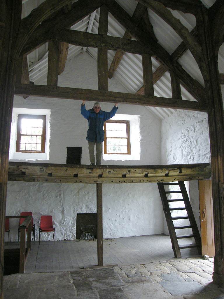
 Penarth
Fawr is was built in the mid 15th century and has 18th century renovations. It
was built by Madoc of Penarth in 1416, to a design known as an aisled truss
hall house. Most of the original 15th
century features still remain. The core
of the house is an open hall, heated only by a central hearth on the floor,
with private quarters at one end and service rooms at the other. Smoke from the
central hearth escaped through a vent, or louver, in the roof. The position of
the louver is marked a small louver truss. The fireplace is dated to 1615, when
a first floor was inserted into the high-roofed open hall. The most striking feature of Penarth Fawr is
the elaborate truss system that braces the structure. The trusses are showing
signs of age and have required recent repairs, but show in beautiful detail how
a house of this period was built.
Penarth
Fawr is was built in the mid 15th century and has 18th century renovations. It
was built by Madoc of Penarth in 1416, to a design known as an aisled truss
hall house. Most of the original 15th
century features still remain. The core
of the house is an open hall, heated only by a central hearth on the floor,
with private quarters at one end and service rooms at the other. Smoke from the
central hearth escaped through a vent, or louver, in the roof. The position of
the louver is marked a small louver truss. The fireplace is dated to 1615, when
a first floor was inserted into the high-roofed open hall. The most striking feature of Penarth Fawr is
the elaborate truss system that braces the structure. The trusses are showing
signs of age and have required recent repairs, but show in beautiful detail how
a house of this period was built.

Ferris wheels: None.
Diversions: None.
How we got there and back: We were staying in our caravan in Snowdonia. This morning we drove to Criccieth where we parked by the waterfront. We walked to the village centre and caught a bus to Pwllheli.
At the end we came upon our car parked in Criccieth. We had our tea and biscuits, then returned to our caravan.

Today is our 48th Wedding Anniversary! Gosh, how time flies by — it’s only two years
to our Golden! It’s not the first time
we’ve been walking the coast on our anniversary, so we’d better get on with it.
 We started today’s Walk at the War Memorial in Pwllheli. As we walked round the harbour we were
appalled to discover that it would have cost £7.50 to park on the north side of
the harbour last Monday whereas it was free to park on the west side where we
did! We thought the rain had stopped,
but it soon started again. We sat in a
shelter to eat our pie/croissant and put on our wet-weather gear.
We started today’s Walk at the War Memorial in Pwllheli. As we walked round the harbour we were
appalled to discover that it would have cost £7.50 to park on the north side of
the harbour last Monday whereas it was free to park on the west side where we
did! We thought the rain had stopped,
but it soon started again. We sat in a
shelter to eat our pie/croissant and put on our wet-weather gear.
 We came to the end and thought we had boobed
because the tide was in, but the path did continue along the top of the
beach. At the beginning the path was
overgrown with bushes, but we did manage to walk round them. We were protected from the wind at first, but
photography was restricted because of the poor visibility.
We came to the end and thought we had boobed
because the tide was in, but the path did continue along the top of the
beach. At the beginning the path was
overgrown with bushes, but we did manage to walk round them. We were protected from the wind at first, but
photography was restricted because of the poor visibility.


We saw a holiday chalet overhanging the edge of the soft sandy cliff, and it reminded us of the erosion we saw on the east coast, particularly around Mundesley in Norfolk. We came to some rocks under a bit of overhanging cliff where it was less wet and windy. So I sat down to eat my sarnies (perhaps a bit foolish, in retrospect). Colin marched off “to look for a better place”, but having tried three different spots he came back and grumpily sat down beside me. It reminded me of that hilarious play “East of Ipswich” – I think Michael Palin wrote it – which was on television yonks ago. (I do wish they would repeat it.)


Colin started walking up a ghost of a path leading to the top of the dunes. Three times I asked him if it was a decent path, because it didn’t look as if it was, but he wouldn’t answer me — wet and windy weather always puts him in a bad mood. He was determined to follow it, so I followed him. I shouldn’t have. The ‘path’ deteriorated at the top, I caught my foot in a loopy root and fell headlong! I wasn’t hurt, but I was a bit shocked. I fell downhill so my feet ended up higher than my head. I had great difficulty getting up, I even had dirt on my face. A man came rushing up from the beach — the first person we had seen since Pwllheli — because he had seen me fall but I assured him I was OK. He asked, “Is that a better path?” and Colin answered, “Don’t know, we’ve not been here before!” He said, “I’m going the beach way!” and disappeared downhill, later joining his friends at the gate leading on to the headland. I wanted to return to the beach, but Colin was still determined to carry on even though the ‘path’ had completely disappeared. Sometimes the ferns were over our heads! We got to the gate eventually.


We crossed fields and the railway, which was rusty because it hasn’t been used since the bridge at Penrhyndeudraeth was washed away last February. We came to the river again — we hadn’t followed its meanders — where it runs parallel to the coast. We met a number of other walkers going the other way on this stretch.


Criccieth
Castle


Penarth Fawr


No comments:
Post a Comment