Location: Harlech to Barmouth.
Distance: 15 miles.
Total
distance: 3717 miles.
Terrain: A lot
of firm sandy beach. Some road. Some grassy paths across marshes. Mostly flat, except in the dunes where we got
lost!
Tide: Out when
we wanted it to be so.
Rivers: No.437,
Afon Artro. No.438, Afon Ysgethin.
Ferries: None.
Piers: None.
Kissing gates: Nos.773 to 783 (11 in all) across the
marshes.
Pubs: None.
‘Cadw’ properties: None.
Ferris wheels: None.
Diversions: None.
How
we got there and back: We were staying
in our caravan in Snowdonia. This
morning we drove from there to Barmouth where, once more, we rejected the
paying car park. We parked in a wide
layby just outside the town, then walked in to the station where we caught a
train to Harlech.
At the end we finished the Walk at the ferry steps. It was almost dark, but there were lots of street lights, even at the out-of-town layby where we were parked We walked out to there, had our tea and biscuits, then drove back to our caravan.
 We started today’s Walk at Harlech Station. We walked straight down the road to the beach
car park by the golf course where we didn’t park last time because it’s too
expensive. A path then took us to the
beach over the dunes, where there were notices warning us not to stay on the
golf course. We sat on the edge of the
dunes to eat our pies.
We started today’s Walk at Harlech Station. We walked straight down the road to the beach
car park by the golf course where we didn’t park last time because it’s too
expensive. A path then took us to the
beach over the dunes, where there were notices warning us not to stay on the
golf course. We sat on the edge of the
dunes to eat our pies.
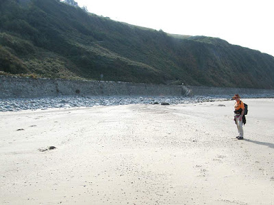 There followed a lovely walk of about one and a half miles along a firm
sandy beach. The Wales Coast Path is not
marked on our recently bought OS map, so we were on the lookout all the while
for a way off. We hoped we would be able
to walk round the end of the cliff on a kind of ridge, but it turned out this
ridge was the railway so that was not possible.
The sandy beach eventually deteriorated into rocks, but not before we
had seen some steps leading up to a simple railway crossing, then a zigzag path
leading up to the top of the steep cliff.
There followed a lovely walk of about one and a half miles along a firm
sandy beach. The Wales Coast Path is not
marked on our recently bought OS map, so we were on the lookout all the while
for a way off. We hoped we would be able
to walk round the end of the cliff on a kind of ridge, but it turned out this
ridge was the railway so that was not possible.
The sandy beach eventually deteriorated into rocks, but not before we
had seen some steps leading up to a simple railway crossing, then a zigzag path
leading up to the top of the steep cliff.
 I stood at the bottom thinking, “Oh! My knee!”
I had only come on this series of Walks with my dodgy knee because I
thought the terrain was fairly flat. I
hadn’t bargained on having to climb the cliffs!
But I had no choice. I had taken
painkillers before we left the caravan, and had more in my pack for when they
wore off. So I hauled myself up the
initial steep steps, crossed the railway, then tackled the eighty steps on the
zigzag path using the rail to haul myself up with my hands. Colin found a bench in the shade at the top,
so we sat there for a good five minutes to recover.
I stood at the bottom thinking, “Oh! My knee!”
I had only come on this series of Walks with my dodgy knee because I
thought the terrain was fairly flat. I
hadn’t bargained on having to climb the cliffs!
But I had no choice. I had taken
painkillers before we left the caravan, and had more in my pack for when they
wore off. So I hauled myself up the
initial steep steps, crossed the railway, then tackled the eighty steps on the
zigzag path using the rail to haul myself up with my hands. Colin found a bench in the shade at the top,
so we sat there for a good five minutes to recover.
 We came out on to a main road, but there was a pavement. Just round the corner we turned on to a much
quieter road. The views from up there
were magnificent! We could see over the
next estuary. Colin looked through his
binoculars and announced, “There’s no footbridge across the river!” Well, there was one marked on the map — a bit
inland so I assumed he wasn’t looking in the right place and carried on. The quiet road descended to sea level (what a waste of effort it had been climbing
all the way up that cliff!) where we crossed the railway again at a station
and on to a car park.
We came out on to a main road, but there was a pavement. Just round the corner we turned on to a much
quieter road. The views from up there
were magnificent! We could see over the
next estuary. Colin looked through his
binoculars and announced, “There’s no footbridge across the river!” Well, there was one marked on the map — a bit
inland so I assumed he wasn’t looking in the right place and carried on. The quiet road descended to sea level (what a waste of effort it had been climbing
all the way up that cliff!) where we crossed the railway again at a station
and on to a car park.
 A café was a welcome sight. We fancied
an ice cream. Then we fancied a cup of
tea. The truth was we were very hot, my
knee was aching, and we didn’t really want to continue today. We had to in the end, of course. (We
don’t do HOT!)
A café was a welcome sight. We fancied
an ice cream. Then we fancied a cup of
tea. The truth was we were very hot, my
knee was aching, and we didn’t really want to continue today. We had to in the end, of course. (We
don’t do HOT!)
We went through a gate where there was a tiny and very ancient chapel. It was so small the lychgate was almost as big. We couldn’t get inside the chapel, so we looked at the gravestones which dated back to the fifth century, so they said. A notice told us that since 2009 there was no room for any more burials.

 We couldn’t cross the river when we came to it, so we walked a little bit
inland alongside it admiring the wild flowers we passed. In the distance we could see tall-masted
boats moored up, which explained why there was no footbridge at the mouth of the
river.
We couldn’t cross the river when we came to it, so we walked a little bit
inland alongside it admiring the wild flowers we passed. In the distance we could see tall-masted
boats moored up, which explained why there was no footbridge at the mouth of the
river.
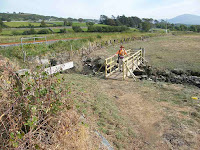 We thought we would have to cross
the railway yet again when we came to it, but a Wales Coast Path logo directed
us to the right where there was a new wooden footbridge over a ditch. We crossed a marshy field — dry, thank
goodness — alongside the railway, but there was no signage as to where to go
next.
We thought we would have to cross
the railway yet again when we came to it, but a Wales Coast Path logo directed
us to the right where there was a new wooden footbridge over a ditch. We crossed a marshy field — dry, thank
goodness — alongside the railway, but there was no signage as to where to go
next.
 Our only option was to go through
a gate into a courtyard within a building.
It seemed to be some kind of activity centre with rows of canoes etc. in
sheds. Then we crossed the railway at
another station (the stations seem to be very close together on this line) and
out on to the main road again.
Our only option was to go through
a gate into a courtyard within a building.
It seemed to be some kind of activity centre with rows of canoes etc. in
sheds. Then we crossed the railway at
another station (the stations seem to be very close together on this line) and
out on to the main road again.
 This time we had about a quarter of a mile to walk alongside the traffic,
But there was a pavement, and after a while it went behind a hedge which shielded
us from the speedsters. We turned on to
a path where there were loads of ripe blackberries — so we helped
ourselves! And there was a brand new
footbridge across the river. There was a
shoe hanging on the fancy gate on the further side. We walked along the other bank to some shady
trees where we stopped to eat our sarnies.
This time we had about a quarter of a mile to walk alongside the traffic,
But there was a pavement, and after a while it went behind a hedge which shielded
us from the speedsters. We turned on to
a path where there were loads of ripe blackberries — so we helped
ourselves! And there was a brand new
footbridge across the river. There was a
shoe hanging on the fancy gate on the further side. We walked along the other bank to some shady
trees where we stopped to eat our sarnies.
 We came out on to a road, crossed the railway by yet another station, and
route-marched along a zigzag road past a small airfield. Colin remembered landing there when he worked
for the RAE in Farnborough in the early 60s — he used to be paid extra “danger
money” for being a lookout on flights, but can’t remember what he was supposed
to be looking out for! Our map says this
airfield is disused, but it isn’t because we watched a plane taking off. We think a small private club now uses it.
We came out on to a road, crossed the railway by yet another station, and
route-marched along a zigzag road past a small airfield. Colin remembered landing there when he worked
for the RAE in Farnborough in the early 60s — he used to be paid extra “danger
money” for being a lookout on flights, but can’t remember what he was supposed
to be looking out for! Our map says this
airfield is disused, but it isn’t because we watched a plane taking off. We think a small private club now uses it.
It was hot in the sun, and there wasn’t any breeze. Colin said, “I’m not enjoying this!” Neither was I. At the end of the road we saw a Wales Coast Path sign leading us off to the left. Mistake! We should have stayed on the road if we wanted to get to the beach.
 But we followed a very straight new concrete
path across the marsh. We had put the
map away because we were following the logos — that was a mistake too. We passed a couple on bikes who were watching
planes, and route-marched towards a gate.
We didn’t notice any path going off, we should have looked at the map
but we didn’t. Through the gate and on
and on we marched thinking we were sloping towards the coast. But we weren’t.
But we followed a very straight new concrete
path across the marsh. We had put the
map away because we were following the logos — that was a mistake too. We passed a couple on bikes who were watching
planes, and route-marched towards a gate.
We didn’t notice any path going off, we should have looked at the map
but we didn’t. Through the gate and on
and on we marched thinking we were sloping towards the coast. But we weren’t.
Through another gate — and the concrete path turned to sand. No logos. So we carried straight on through a wood where campers were pitched amongst the trees. Then it all came to an end.
 A track went across us from
right to left. Eh? We were quite lost! So we got out the map, and realised we were
nowhere near the coast but about a mile inland.
The map showed a public footpath going straight to the coast from where
we thought we were, but that didn’t exist in reality. We turned right on to the track, but that
wiggled about and very soon disappeared into nothing. We met a man on a bike, and asked him if the
way he had just come was the way to the beach.
He said, “Er, yes!” but he
didn’t sound very sure and he didn’t stop.
Now we were really on our own! All we
could see in any direction were dunes, some covered in vegetation and some
loose sand. It was a nightmare!
A track went across us from
right to left. Eh? We were quite lost! So we got out the map, and realised we were
nowhere near the coast but about a mile inland.
The map showed a public footpath going straight to the coast from where
we thought we were, but that didn’t exist in reality. We turned right on to the track, but that
wiggled about and very soon disappeared into nothing. We met a man on a bike, and asked him if the
way he had just come was the way to the beach.
He said, “Er, yes!” but he
didn’t sound very sure and he didn’t stop.
Now we were really on our own! All we
could see in any direction were dunes, some covered in vegetation and some
loose sand. It was a nightmare!
 We were so hot, neither of us felt we could cope. We got out the compass and argued about it,
none of which helped. We climbed a dune
to see where we were, but all we could see was more dunes.
We were so hot, neither of us felt we could cope. We got out the compass and argued about it,
none of which helped. We climbed a dune
to see where we were, but all we could see was more dunes.
 It was difficult for me to get down with my
bad knee, and we did this at least three times.
Colin was all for sticking to the valleys, but there we couldn’t see
where we were going. I just wanted to
get to the beach. Eventually we climbed
a steep dune through brambles and trees — and there was the beach below!
It was difficult for me to get down with my
bad knee, and we did this at least three times.
Colin was all for sticking to the valleys, but there we couldn’t see
where we were going. I just wanted to
get to the beach. Eventually we climbed
a steep dune through brambles and trees — and there was the beach below!
 Trouble was, we were at the top of a vertical
cliff. We chose our spot, and slid down
through dry soft sand on our bums! At
last we were on the beach!
Trouble was, we were at the top of a vertical
cliff. We chose our spot, and slid down
through dry soft sand on our bums! At
last we were on the beach!
I was all in, hot and dehydrated. I didn’t know if I could carry on. There was nothing to sit on, so Colin filled a broken polythene container with sand and we sat on that to eat our chocolate. There were a few people scattered about here and there on this vast lonely beach, and we gradually realised that none of them had any clothes on!! We started to laugh, and laugh and laugh which made us both feel very much better.

 We started walking south. The
beach was mostly nice firm sand, there was a very gentle breeze now we were out
in the open, and it got a tad cooler as time progressed. We actually began to enjoy it. The dunes stretched for miles, and gradually
the people we met were scantily clad, later on they were properly clothed. Colin noticed a Wales Coast Path logo at the
top of the beach pointing inland, but we ignored it. Those logos had let us down too often, we
were going our own way.
We started walking south. The
beach was mostly nice firm sand, there was a very gentle breeze now we were out
in the open, and it got a tad cooler as time progressed. We actually began to enjoy it. The dunes stretched for miles, and gradually
the people we met were scantily clad, later on they were properly clothed. Colin noticed a Wales Coast Path logo at the
top of the beach pointing inland, but we ignored it. Those logos had let us down too often, we
were going our own way.

 The dunes came to an end where a small river babbled across the beach,
shallow enough to paddle through. We
realised later that we had camped just inland next to this river with our four
children back in 1980. Past there were
some rocks shielding holiday homes from shifting sands. We sat on them to eat our apples.
The dunes came to an end where a small river babbled across the beach,
shallow enough to paddle through. We
realised later that we had camped just inland next to this river with our four
children back in 1980. Past there were
some rocks shielding holiday homes from shifting sands. We sat on them to eat our apples.
 We were beginning to lose the light. We were pleased the tide was out as far as it
was, but after another two miles it had come in too far for us to continue on
the beach. The cycleway which was marked on the OS map didn’t exist. We were a bit disappointed because we had
expected to stay on the beach all the way into Barmouth.
We were beginning to lose the light. We were pleased the tide was out as far as it
was, but after another two miles it had come in too far for us to continue on
the beach. The cycleway which was marked on the OS map didn’t exist. We were a bit disappointed because we had
expected to stay on the beach all the way into Barmouth.
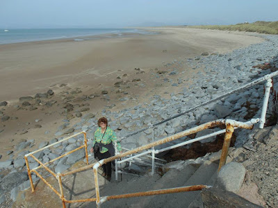
 But it was not to be — we were too late for the tide. Just before the railway sloped in to the top
of the beach, we climbed up the shingle — with great difficulty because of my
dodgy knee — and found a simple crossing of the line. Then we went further up through a caravan
site to the road. We were really losing
the light now. We hate walking along
roads, but fortunately there was a pavement.
A logo on a post told us we were still on the Wales Coast Path.
But it was not to be — we were too late for the tide. Just before the railway sloped in to the top
of the beach, we climbed up the shingle — with great difficulty because of my
dodgy knee — and found a simple crossing of the line. Then we went further up through a caravan
site to the road. We were really losing
the light now. We hate walking along
roads, but fortunately there was a pavement.
A logo on a post told us we were still on the Wales Coast Path.
 We passed Llanaber Church,
and after about a mile we saw a sign which read, “To the Beach”. We descended
a steep narrow road to Barmouth prom.
We passed Llanaber Church,
and after about a mile we saw a sign which read, “To the Beach”. We descended
a steep narrow road to Barmouth prom.
 There were people in the sea having a late swim even though it was now
getting dark. But it had been a very hot
day, and the sea is at its warmest at this time of year. There was still another mile or so to
Barmouth town along the promenade, with paying car parks all the way.
There were people in the sea having a late swim even though it was now
getting dark. But it had been a very hot
day, and the sea is at its warmest at this time of year. There was still another mile or so to
Barmouth town along the promenade, with paying car parks all the way.
 There was no sign of the beach huts which my
Dad hired when he brought here us on holiday in 1962. (That was a year before I met Colin, I was
seventeen.) It was almost dark when we
reached a row of terraced houses across the road. One of them was the boarding house where we
stayed in 1962 for two weeks, but I can’t remember which one it was. We had bed and board, i.e. three substantial
meals each day. But the bathroom
facilities were shared, and it cost an extra shilling every time we had a
bath! (No showers in those days.)
There was no sign of the beach huts which my
Dad hired when he brought here us on holiday in 1962. (That was a year before I met Colin, I was
seventeen.) It was almost dark when we
reached a row of terraced houses across the road. One of them was the boarding house where we
stayed in 1962 for two weeks, but I can’t remember which one it was. We had bed and board, i.e. three substantial
meals each day. But the bathroom
facilities were shared, and it cost an extra shilling every time we had a
bath! (No showers in those days.)

 We ended the Walk at the ferry which crosses the Mawddach Estuary to Fairbourne
— it was closed by that time, of course.
It was quite dark by then, but fortunately I had taken several photos of
Barmouth and the famous Barmouth railway bridge in the morning before boarding
the train to Harlech. We passed a plaque
marking the spot where an old-fashioned signal box once stood.
We ended the Walk at the ferry which crosses the Mawddach Estuary to Fairbourne
— it was closed by that time, of course.
It was quite dark by then, but fortunately I had taken several photos of
Barmouth and the famous Barmouth railway bridge in the morning before boarding
the train to Harlech. We passed a plaque
marking the spot where an old-fashioned signal box once stood.
 We puzzled over a sculpture we came across, but looked it up later on the
internet. Apparently it
shows three generations of fishermen hauling in their nets, they are pulling on
a thick rope and leaning backwards. We
thought it was a bit weird. It was
carved from a large block of Italian Carrara white marble which was part of a
cargo recovered in 1978 from a wreckage of a foreign ship which sank off the
coast of Talybont in 1709.
We puzzled over a sculpture we came across, but looked it up later on the
internet. Apparently it
shows three generations of fishermen hauling in their nets, they are pulling on
a thick rope and leaning backwards. We
thought it was a bit weird. It was
carved from a large block of Italian Carrara white marble which was part of a
cargo recovered in 1978 from a wreckage of a foreign ship which sank off the
coast of Talybont in 1709.
 We walked across Barmouth
Bridge on one of our rest
days, and then walked back. Colin and I
spent our honeymoon in a tiny B&B just the other side of the bridge, and
used to walk over into Barmouth daily.
So it was quite nostalgic for us.
We will not be using the bridge on our next Walk because we are going to
catch the ferry to Fairbourne.
We walked across Barmouth
Bridge on one of our rest
days, and then walked back. Colin and I
spent our honeymoon in a tiny B&B just the other side of the bridge, and
used to walk over into Barmouth daily.
So it was quite nostalgic for us.
We will not be using the bridge on our next Walk because we are going to
catch the ferry to Fairbourne.
 That ended Walk
no.360, we shall pick up Walk no.361 next time at the ferry steps in
Barmouth. It was eight o’clock, so the
Walk had taken us nine hours thirty minutes.
It was almost dark, but there were lots of street lights, even at the
out-of-town layby where we were parked
We walked out to there, had our tea and biscuits, then drove back to our
caravan.
That ended Walk
no.360, we shall pick up Walk no.361 next time at the ferry steps in
Barmouth. It was eight o’clock, so the
Walk had taken us nine hours thirty minutes.
It was almost dark, but there were lots of street lights, even at the
out-of-town layby where we were parked
We walked out to there, had our tea and biscuits, then drove back to our
caravan.
At the end we finished the Walk at the ferry steps. It was almost dark, but there were lots of street lights, even at the out-of-town layby where we were parked We walked out to there, had our tea and biscuits, then drove back to our caravan.


We went through a gate where there was a tiny and very ancient chapel. It was so small the lychgate was almost as big. We couldn’t get inside the chapel, so we looked at the gravestones which dated back to the fifth century, so they said. A notice told us that since 2009 there was no room for any more burials.


It was hot in the sun, and there wasn’t any breeze. Colin said, “I’m not enjoying this!” Neither was I. At the end of the road we saw a Wales Coast Path sign leading us off to the left. Mistake! We should have stayed on the road if we wanted to get to the beach.

Through another gate — and the concrete path turned to sand. No logos. So we carried straight on through a wood where campers were pitched amongst the trees. Then it all came to an end.


I was all in, hot and dehydrated. I didn’t know if I could carry on. There was nothing to sit on, so Colin filled a broken polythene container with sand and we sat on that to eat our chocolate. There were a few people scattered about here and there on this vast lonely beach, and we gradually realised that none of them had any clothes on!! We started to laugh, and laugh and laugh which made us both feel very much better.


No comments:
Post a Comment