Ages: Colin was 64 years and 63 days. Rosemary was 61 years and 205 days.
Weather: Sunny turning cloudy. Occasional light showers.
Location: Seaburn to North Shields, via South Shields.
Distance: 10½ miles.
Total distance: 1109 miles.
Terrain: Well marked cliff paths and cycle tracks. Concrete in South Shields.
Tide: In.
Rivers: No.59, the Tyne between South and North Shields.
Ferries: No.12, across the Tyne at South Shields. Cost £1 each.
Piers: None.
Kissing gates: No.101 at the beginning of the military rifle range at Whitburn.
Pubs: ‘Alum Ale House’ at the ferry landing, South Shields, where we enjoyed Durham ‘Ruby’, Northumberland ‘Keepie Uppie’ and 3 Rivers ‘Robo Hop’.
‘English Heritage’ properties: None.
Ferris wheels: No.8 at Seaburn, but it was CLOSED! (Looking at it carefully, I was really rather glad because it looked as if it turned you upside-down!)
Diversions: None.
How we got there and back: We were camping at Hinderwell. We drove to South Shields and parked by the side of the road in the shade of a high wall. We walked a short distance to the nearest metro station, caught a train to Pelaw then another one to Seaburn. There we walked about a mile down to the seafront.
At the end we only pretended to go on the ferry when we got to South Shields, saving us a total of £4. We spent that (and more!) in the pub instead, and then walked back to our car. We drove back to Hinderwell.

 Colin was very interested in a couple of ‘Pullman’ train carriages outside an hotel at the beginning of today’s Walk. They were static and being used as part of the restaurant.
I was more interested in the Ferris wheel which was just beyond them. It was still closed this morning, as was all the funfair, even though it is the middle of July. We could hardly be more ‘in season’, though I suppose the schools haven’t broken up yet. When we got up to the Ferris wheel I was really rather glad that it wasn’t going, for it looked as if the cars turned you upside-down! I can’t take that at my age — I think I had a lucky escape!
We admired a lovely mosaic in the pavement, and moved on. At the end of the prom I announced that we had walked exactly eleven hundred miles from our starting point, Bognor Regis. We asked a passing walker to take an appropriate photo of us. She was very impressed when we told her of our achievement — we felt quite proud of ourselves.
 After
After  that the path left the adjacent road and looped along the clifftops for several miles. It was an easy gravel path all the way, wide enough for wheelchairs and pushchairs. We were very impressed. We met a lot of joggers out today, even though it is a Monday.
  However, we also saw evidence of vandalism when we passed a burnt-out boathouse.
We came to a military rifle range. On the map it showed the public footpath going right through the ‘DANGER AREA’. I was hoping that it wouldn’t be in use today as I didn’t want to walk round, but we had no idea until we got there what was happening. I needn’t have worried, for there was no shooting today and the coast path was open. We had not expected this part of the coast to be very picturesque, being as we were really in a built-up area not far from the city of Newcastle-upon-Tyne.
  But we were agreeably surprised — there were lots of rock stacks, small caves and even arches.
  One rock stack was crowded with birds, they covered the whole of the top.
  We debated as to whether they were shags or cormorants, and decided eventually that they were the latter.
  Kittiwakes nested on another stack, mostly on narrow ledges down the side. We wondered how many of their chicks fell to their deaths in the sea far below — one wrong move…
  The whole area was varied and full of interest.
  Colin even came across a wild orchid growing beautifully in the grass.
 In the ‘Whitburn Coastal Park’ we sat on one of the many memorial seats to eat our lunch. We saw a lighthouse ahead with a large swathe of grass in front. As we topped the mound we could see a line of redundant lime kilns at the back. A notice told us:
The brick and stone structures ahead are the Marsden limekilns. They were built from the late 1870s. They burnt lime which was used on farms and in steel mills across the country and abroad. The limestone was quarried nearby and the coal was mined at the Whitburn Colliery. Both colliery and kilns closed in the 1960s, though the quarry remains working to this day.
Another notice told us of a village that vanished:
Would you believe that there was once a village between here and the Souter lighthouse? Marsden village, built in the 1870s for the miners of Whitburn Colliery and their families, once stood here. This self-contained community of nine terraces included a Co-op store, Methodist Chapel, Miners’ Institute and Reading Room and allotments. It was demolished at various stages and by 1977 it was all gone, forming the green open space you see today.
We walked over the wide open space, and continued along the clifftop marvelling at the numerous rock stacks with their resident bird colonies.


 I kept having a feeling of “déjà-vu”, it was most weird. I couldn’t remember having been there before but it all seemed vaguely familiar. It wasn’t until we came upon a cliff-lift stuck out from the cliff face on a kind of stalk that I recognised it. I had been there before — on an Open University Summer School nearly twenty years ago when I had been studying Geology. I remembered a conversation I’d had with my Dad about the cliff lift — he had once been to Newcastle on business, probably back in the 1950s, and had been taken in this lift down to the beach where he had dined in a small pub which was in a cave! He was marvelling at it, as a Civil Engineer it was the engineering side of the structure which interested him — and the novelty.
 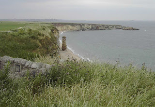 When I visited in the 1980s it looked redundant, as I remember, and here in the 21st century it didn’t look as if it had been working for years. However, I have just looked it up on the internet and it appears that it is still open. Perhaps we didn’t look carefully enough, we didn’t go down to the beach either time.
Having reminded myself of the 1980s visit by the cliff lift, I looked around to see what else I could recall. I vaguely remembered a rock stack which resembles a chimney stack, but I could not recollect Marsden Rock at all, and that was the feature I was most probably brought here to see. It would have been a rock arch then. A notice informed us:
The large stack in front of you is the remaining part of the once mighty Marsden Rock and Victorian visitors flocked here to climb the stairs to the top. It used to be much larger with a natural arch. Severe frosts following years of constant battering by seas and storms brought down the arch in February 1996. The dangerous smaller stack was blown up a year later to prevent its uncontrolled collapse.
Included on the notice was a picture of the top of the arch crowded with people holding a choral service in 1903. (Of course, they didn’t have ‘Health & Safety’ officials breathing down their necks in those days!)
 - - - - - - - - - - - - - - - - - - - - - - - - -- - - - - - - - -

 There were lots of people walking their dogs, jogging, etc along this delightful coastal path. We got talking to one local resident who was pointing out the two piers each side of the mouth of the River Tyne, each with a lighthouse on the end. We asked him if the South Pier was open to walkers, because if it was we would have to walk it today. He replied in horror, “You wouldn’t want to go all that way, it must be at least a mile away!” We couldn’t think of an answer to that.
 We descended to the beautiful beach of South Shields. In our mind’s eye we had thought of this whole area as being dark, dirty and industrial. So we were in for an enormous surprise. South Shields beach is beautiful! It has pristine golden sand, very clean with loads of litter bins so there is no excuse. The buildings are freshly painted, lovely flower gardens are everywhere, and the toilets (clean, open and free) are housed in a Grecian Temple!!
  I really take my hat off to whoever is responsible for the beach area — Bognor could certainly learn a lesson or two.
There was a paved path all the way across to South Pier, so we didn’t have to walk on sinky soft sand. The stone pier was open to walkers, so we walked the length of it even though it was a dead end. It is nearly a mile long in itself, and was lined with fishermen many of whom were young boys. It is good to see young people absorbed in a hobby, even though I can never understand what they get out of standing still with a rod and line. Most of them looked freezing cold — I’d rather be doing something outdoors which expends energy so that I can keep warm. However, each to his own.
 We walked to the lighthouse and back, then across a beach towards South Groyne. We watched a passenger ship sail out of the River Tyne and across the harbour to the entrance between the two lighthouses. When we first espied it, it looked most odd because it was so big and gave the impression it was sailing across the sand!
 We didn’t walk the length of South Groyne, although it was very short compared with South Pier which we had just walked, because we were very tired by then and just making excuses — “It’s a dead end so we don’t have to!” — “Oh, that’s all right then, let’s get to the pub!”
 We came upon an open paved space where there were a number of intriguing sculptures. I can only describe them as diddy-ladies who appeared to be dancing.
  We couldn’t roll them over, nor move them at all, but they were at all angles, had round bases and very small heads. We ‘danced’ with them a bit, and then moved on. We walked along in front of some posh new houses, but then we realised we had been lumbered because we came to an unfriendly fence and couldn’t get through. We had to backtrack, which in our tired state was not a popular move, in order to get out on to the road.
Over the fence which barred our way we could see another unusual sculpture — a huge hand reaching up to the sky. It appeared to be in a derelict boatyard with weeds growing head-high. We wondered if it was a memorial to a drowning man, as we have seen similar such memorials in other places around the world. But it looked so forlorn and neglected — I felt sad. We peeped through an open gate from the road, and saw that the hand had a hole in the middle with some kind of figure in it. Whether there was a plaque or not we didn’t find out — the surrounding fence looked so vicious we daren’t approach beyond the gate. We were far too tired for confrontation.
 We passed our car parked by its high wall without being tempted to stop and treat ourselves to a cup of tea. (We knew that if we did, we would never complete the Walk to the ferry terminal, and it was essential that we did so because tomorrow’s Walk starts on the other side of the river.) We took a road sloping downwards which we dubbed ‘Factory Lane’ and it returned us to the river side. Then it was a wiggly route through a newly paved pedestrian area to the ferry terminal which saved us climbing a hill unnecessarily. We came across yet another sculpture, that of a lady wearing very little clothing, hair flowing in the wind and holding a ship in full sail under her arm. I tried to copy her stance, but I kept my clothes on!
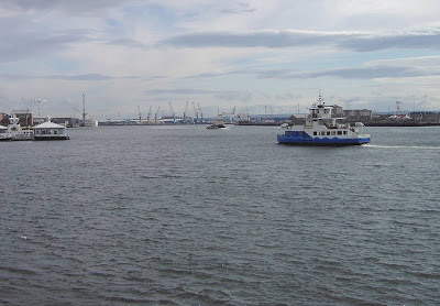 The ferry to North Shields would have cost us each £1 to go over, then another £1 each to come back because our car was parked in South Shields. So we pretended.
That ended Walk no.137, we shall pick up Walk no.138 next time by the other ferry terminal in North Shields. We went to the ‘real ale’ pub which was right by the ferry landing where we quickly spent the £4 we had saved by not going on the ferry. We walked back to the car, had our tea, and then drove all the way back to our campsite at Hinderwell.
Location: Seaburn to North Shields, via South Shields.
Distance: 10½ miles.
Total distance: 1109 miles.
Terrain: Well marked cliff paths and cycle tracks. Concrete in South Shields.
Tide: In.
Rivers: No.59, the Tyne between South and North Shields.
Ferries: No.12, across the Tyne at South Shields. Cost £1 each.
Piers: None.
Kissing gates: No.101 at the beginning of the military rifle range at Whitburn.
Pubs: ‘Alum Ale House’ at the ferry landing, South Shields, where we enjoyed Durham ‘Ruby’, Northumberland ‘Keepie Uppie’ and 3 Rivers ‘Robo Hop’.
‘English Heritage’ properties: None.
Ferris wheels: No.8 at Seaburn, but it was CLOSED! (Looking at it carefully, I was really rather glad because it looked as if it turned you upside-down!)
Diversions: None.
How we got there and back: We were camping at Hinderwell. We drove to South Shields and parked by the side of the road in the shade of a high wall. We walked a short distance to the nearest metro station, caught a train to Pelaw then another one to Seaburn. There we walked about a mile down to the seafront.
At the end we only pretended to go on the ferry when we got to South Shields, saving us a total of £4. We spent that (and more!) in the pub instead, and then walked back to our car. We drove back to Hinderwell.

 Colin was very interested in a couple of ‘Pullman’ train carriages outside an hotel at the beginning of today’s Walk. They were static and being used as part of the restaurant.
I was more interested in the Ferris wheel which was just beyond them. It was still closed this morning, as was all the funfair, even though it is the middle of July. We could hardly be more ‘in season’, though I suppose the schools haven’t broken up yet. When we got up to the Ferris wheel I was really rather glad that it wasn’t going, for it looked as if the cars turned you upside-down! I can’t take that at my age — I think I had a lucky escape!
We admired a lovely mosaic in the pavement, and moved on.
 At the end of the prom I announced that we had walked exactly eleven hundred miles from our starting point, Bognor Regis. We asked a passing walker to take an appropriate photo of us. She was very impressed when we told her of our achievement — we felt quite proud of ourselves.
 After
After  that the path left the adjacent road and looped along the clifftops for several miles. It was an easy gravel path all the way, wide enough for wheelchairs and pushchairs. We were very impressed. We met a lot of joggers out today, even though it is a Monday.
  However, we also saw evidence of vandalism when we passed a burnt-out boathouse.
We came to a military rifle range. On the map it showed the public footpath going right through the ‘DANGER AREA’. I was hoping that it wouldn’t be in use today as I didn’t want to walk round, but we had no idea until we got there what was happening. I needn’t have worried, for there was no shooting today and the coast path was open.
 We had not expected this part of the coast to be very picturesque, being as we were really in a built-up area not far from the city of Newcastle-upon-Tyne.
  But we were agreeably surprised — there were lots of rock stacks, small caves and even arches.
  One rock stack was crowded with birds, they covered the whole of the top.
  We debated as to whether they were shags or cormorants, and decided eventually that they were the latter.
  Kittiwakes nested on another stack, mostly on narrow ledges down the side. We wondered how many of their chicks fell to their deaths in the sea far below — one wrong move…
  The whole area was varied and full of interest.
  Colin even came across a wild orchid growing beautifully in the grass.
 In the ‘Whitburn Coastal Park’ we sat on one of the many memorial seats to eat our lunch. We saw a lighthouse ahead with a large swathe of grass in front. As we topped the mound we could see a line of redundant lime kilns at the back. A notice told us:
The brick and stone structures ahead are the Marsden limekilns. They were built from the late 1870s.
 They burnt lime which was used on farms and in steel mills across the country and abroad. The limestone was quarried nearby and the coal was mined at the Whitburn Colliery. Both colliery and kilns closed in the 1960s, though the quarry remains working to this day.
Another notice told us of a village that vanished:
Would you believe that there was once a village between here and the Souter lighthouse?
 Marsden village, built in the 1870s for the miners of Whitburn Colliery and their families, once stood here. This self-contained community of nine terraces included a Co-op store, Methodist Chapel, Miners’ Institute and Reading Room and allotments. It was demolished at various stages and by 1977 it was all gone, forming the green open space you see today.
We walked over the wide open space, and continued along the clifftop marvelling at the numerous rock stacks with their resident bird colonies.


 I kept having a feeling of “déjà-vu”, it was most weird. I couldn’t remember having been there before but it all seemed vaguely familiar. It wasn’t until we came upon a cliff-lift stuck out from the cliff face on a kind of stalk that I recognised it. I had been there before — on an Open University Summer School nearly twenty years ago when I had been studying Geology. I remembered a conversation I’d had with my Dad about the cliff lift — he had once been to Newcastle on business, probably back in the 1950s, and had been taken in this lift down to the beach where he had dined in a small pub which was in a cave! He was marvelling at it, as a Civil Engineer it was the engineering side of the structure which interested him — and the novelty.
  When I visited in the 1980s it looked redundant, as I remember, and here in the 21st century it didn’t look as if it had been working for years. However, I have just looked it up on the internet and it appears that it is still open. Perhaps we didn’t look carefully enough, we didn’t go down to the beach either time.
Having reminded myself of the 1980s visit by the cliff lift, I looked around to see what else I could recall.
 I vaguely remembered a rock stack which resembles a chimney stack, but I could not recollect Marsden Rock at all, and that was the feature I was most probably brought here to see. It would have been a rock arch then. A notice informed us:
The large stack in front of you is the remaining part of the once mighty Marsden Rock and Victorian visitors flocked here to climb the stairs to the top.
 It used to be much larger with a natural arch. Severe frosts following years of constant battering by seas and storms brought down the arch in February 1996. The dangerous smaller stack was blown up a year later to prevent its uncontrolled collapse.
Included on the notice was a picture of the top of the arch crowded with people holding a choral service in 1903. (Of course, they didn’t have ‘Health & Safety’ officials breathing down their necks in those days!)

 - - - - - - - - - - - - - - - - - - - - - - - - -- - - - - - - - -

- - - - - - - - - - - - - - - - - - - - - - - - - - - - - - - - - -

SITE OF INDUSTRIAL INFILL
POSSIBILITY OF HAZARDOUS WASTE
UNSTABLE CLIFF EDGE
KEEP AWAY FROM THE CLIFF EDGE
DO NOT DIG OR DISTURB THE GROUND
DO NOT REMOVE SUSPICIOUS
OBJECTS
It has certainly been prettied up since my last visit, and opened to the public as a recreation area. Well done the local Council!

A little further on I recognised a long low cliff to our left as being an ancient coral reef formed of magnesian limestone!  I was amazing myself by remembering all the details as we walked along its length. Except that when we had come before the place was a bit of a mess, and I don’t think it was open to the general public. Sure enough, we came to a notice which read:
DANGER I was amazing myself by remembering all the details as we walked along its length. Except that when we had come before the place was a bit of a mess, and I don’t think it was open to the general public. Sure enough, we came to a notice which read:
SITE OF INDUSTRIAL INFILL
POSSIBILITY OF HAZARDOUS WASTE
UNSTABLE CLIFF EDGE
KEEP AWAY FROM THE CLIFF EDGE
DO NOT DIG OR DISTURB THE GROUND
DO NOT REMOVE SUSPICIOUS
OBJECTS
 There were lots of people walking their dogs, jogging, etc along this delightful coastal path. We got talking to one local resident who was pointing out the two piers each side of the mouth of the River Tyne, each with a lighthouse on the end. We asked him if the South Pier was open to walkers, because if it was we would have to walk it today. He replied in horror, “You wouldn’t want to go all that way, it must be at least a mile away!” We couldn’t think of an answer to that.
 We descended to the beautiful beach of South Shields. In our mind’s eye we had thought of this whole area as being dark, dirty and industrial. So we were in for an enormous surprise. South Shields beach is beautiful! It has pristine golden sand, very clean with loads of litter bins so there is no excuse. The buildings are freshly painted, lovely flower gardens are everywhere, and the toilets (clean, open and free) are housed in a Grecian Temple!!
  I really take my hat off to whoever is responsible for the beach area — Bognor could certainly learn a lesson or two.
There was a paved path all the way across to South Pier, so we didn’t have to walk on sinky soft sand. The stone pier was open to walkers, so we walked the length of it even though it was a dead end. It is nearly a mile long in itself, and was lined with fishermen many of whom were young boys. It is good to see young people absorbed in a hobby, even though I can never understand what they get out of standing still with a rod and line. Most of them looked freezing cold — I’d rather be doing something outdoors which expends energy so that I can keep warm. However, each to his own.

 We walked to the lighthouse and back, then across a beach towards South Groyne. We watched a passenger ship sail out of the River Tyne and across the harbour to the entrance between the two lighthouses. When we first espied it, it looked most odd because it was so big and gave the impression it was sailing across the sand!
 We didn’t walk the length of South Groyne, although it was very short compared with South Pier which we had just walked, because we were very tired by then and just making excuses — “It’s a dead end so we don’t have to!” — “Oh, that’s all right then, let’s get to the pub!”
 We came upon an open paved space where there were a number of intriguing sculptures. I can only describe them as diddy-ladies who appeared to be dancing.
  We couldn’t roll them over, nor move them at all, but they were at all angles, had round bases and very small heads. We ‘danced’ with them a bit, and then moved on. We walked along in front of some posh new houses, but then we realised we had been lumbered because we came to an unfriendly fence and couldn’t get through. We had to backtrack, which in our tired state was not a popular move, in order to get out on to the road.
Over the fence
 which barred our way we could see another unusual sculpture — a huge hand reaching up to the sky. It appeared to be in a derelict boatyard with weeds growing head-high. We wondered if it was a memorial to a drowning man, as we have seen similar such memorials in other places around the world. But it looked so forlorn and neglected — I felt sad. We peeped through an open gate from the road, and saw that the hand had a hole in the middle with some kind of figure in it. Whether there was a plaque or not we didn’t find out — the surrounding fence looked so vicious we daren’t approach beyond the gate. We were far too tired for confrontation.
 We passed our car parked by its high wall without being tempted to stop and treat ourselves to a cup of tea. (We knew that if we did, we would never complete the Walk to the ferry terminal, and it was essential that we did so because tomorrow’s Walk starts on the other side of the river.) We took a road sloping downwards which we dubbed ‘Factory Lane’ and it returned us to the river side. Then it was a wiggly route through a newly paved pedestrian area to the ferry terminal which saved us climbing a hill unnecessarily. We came across yet another sculpture, that of a lady wearing very little clothing, hair flowing in the wind and holding a ship in full sail under her arm. I tried to copy her stance, but I kept my clothes on!
 The ferry to North Shields would have cost us each £1 to go over, then another £1 each to come back because our car was parked in South Shields. So we pretended.
That ended Walk no.137, we shall pick up Walk no.138 next time by the other ferry terminal in North Shields. We went to the ‘real ale’ pub which was right by the ferry landing where we quickly spent the £4 we had saved by not going on the ferry. We walked back to the car, had our tea, and then drove all the way back to our campsite at Hinderwell.

No comments:
Post a Comment