Ages: Colin was 64 years and 343 days. Rosemary was 62 years and 120 days.
Weather: Cloudy and cool at the beginning and end of the Walk, but sunny and warm in the middle.
Location: St Abbs, via St Abbs Head, to Dowlaw.
Distance: 8 miles.
Total distance: 1237 miles.
Terrain: Grassy clifftop paths — undulating in the extreme!
Tide: In.
Rivers: None.
Ferries: None.
Piers: None.
Kissing gates: No.125 at the exit to St Abbs Nature Reserve, and nos.126 & 127 further on in different places.
Pubs: None.
‘Historic Scotland’ properties: None.
Ferris wheels: None.
Diversions: None.
How we got there and back: We were staying in a holiday cottage at Grantshouse. With one bike on the back of the car, we drove to St Abbs where Colin dropped me off, and I spent a pleasant hour and a half exploring the harbour. Meanwhile Colin drove to Dowlaw where he parked the car. He scorned the map, saying his cycling route was ‘easy’ and there would be no problem. There was — he got lost! He ended up on footpaths when he should have been on tracks all the way, and had to heave his bike over a couple of gates. But he didn’t lose much time, and found his way eventually, more by luck than by judgement. He padlocked his bike to a fence in St Abbs.
At the end we walked to our car at Dowlaw. We were only a couple of miles from our cottage at Grantshouse, so we hadn’t bothered to make up a flask. Instead we drove straight back and had a ‘proper’ cup of tea made with loose leaves and poured from a teapot! Colin then drove to St Abbs to retrieve the bike while I cooked a meal.
 Colin was quite flustered at the beginning of this Walk because he had lost his way when cycling back to St Abbs from the car. I don’t think he will scorn the map again, even if he is 100% certain of the route! However, he didn’t lose much time, and we started the Walk at 11.40.
  Meanwhile I had been very pleasantly occupied looking round the delightful harbour and trying to interpret the many interesting rocks. The trouble is, it is nigh on twenty years since I did my OU degree in Geology and I have forgotten most of it. The layers in the cliffs seem very twisted, I think a lot has happened to them over geological time.
 We were a trifle nervous about today’s Walk because it was the first of many we would tackle in Scotland where there are no paths marked on the OS map.
  Despite this, there was a clear signposted path leading up from the harbour to St Abbs Head, and a lot of people walking it (only the disabled are allowed to use the lighthouse road). Most of the other hikers were old codgers like us!
  The scenery was absolutely spectacular, the best we have seen so far on this Trek.
  What an introduction to Scotland!
 We sat on the grass overlooking these amazing cliffs to have the first part of our lunch.
We watched with amusement a couple turn off the path on to an almost vertical grassy slope to climb up for a better view. The woman was unhappy about the steepness of the slope, and they started arguing just like Colin and I do! He was most unhelpful, left her behind, and she had to scrabble up with great difficulty to get herself out of trouble. I kept nudging Colin, as we both recognised ourselves in that kind of silly exchange.
 There was a phenomenal amount of bird noise. It was mostly kittiwakes nesting on the cliff-face, but we did watch a shag take some seaweed up to its nest on a rock.
  We watched numerous gannets flying past out at sea.
  We got chatting to a Scottish couple who reckoned they come from Bass Rock and travel many miles each day in search of food. We climbed up past the lighthouse buildings to the very end — the view was breathtaking! We could see the twists and coils in the rocks. The coast turns a kind of ‘corner’ at this point, and the rest of our Walk today was almost due West.
It was also very lonely, as the rest of the world turned back to St Abbs whilst we carried on by ourselves. There were some signposts indicating a coastal path, but not nearly enough so they didn’t join up. There were some stiles, but mostly they didn’t lead anywhere — one took us over a fence into a crop field where it was impossible to proceed so we had to come out again!
  We found the vestige of a footpath every so often, but we think they were only sheep-tracks. There is no path marked on any map we have seen.
 We descended a very steep path to the lighthouse road, crossed a cattle grid and turned right on to the grass. We were almost at sea level, and there was a small stone quay that looked as if it might once have been a fishing harbour. No boats there now, in fact no buildings anywhere around so we concluded it is no longer used.
 We slowly climbed again to the top of a hill where there were some ‘Admiralty Distance Poles’ and sat down to have the rest of our lunch.
  There we planned tactics. We decided to stick to the contours as far as possible, since there was no path, in order to save needless climbing up and down. We made up a new rule about gullies:— “If we come to a steeply sided gully, we can walk round it on the relative flat rather than scramble down into the depths and have to climb out the other side.” (We had seen there were some hideously deep gullies coming up on the map!)
  We were really pleased to find most of the area was covered in short grass, so proceeding without a path was not too difficult.
We made towards a loch as the way looked easier by that route. In the distance a farmer on his quad-bike was herding a few cows. He called across to us, asking us to stop a few minutes until he had negotiated a field gateway because his cows were distracted by us. So we sat down until he had got them all safely in the field with the gate closed. Then he came across and thanked us for co-operating and apologised for holding us up. What a difference in attitude to our English farmers with all their ‘PRIVATE KEEP OUT’ notices!
We had a long chat, after all he was the only person we saw to talk to after St Abbs Head until the end of the day! He gave us a lot of helpful advice, and was impressed with our achievement on the Trek so far. He warned us to steer clear of gullies, he said if he loses a sheep in Dowlaw Dean, a couple of miles further on, he takes his lunch down there as he knows it is going to take all day! He said the authorities are trying to institute a coastal path between St Abbs and Cove, but it is not all worked out yet nor is much of it in place. Hence we came across the occasional signpost pointing to nowhere, and he warned us there may be the odd barbed wire fence to negotiate. He didn’t seem at all bothered that we were walking over his land, and wished us well with a cheery wave.
 We tried to keep to the contours without straying too far from the coast, and the going wasn’t too bad. When we came to field boundaries we mostly found a gate that opened. (We always carefully closed it behind us.) We only had to scale a couple of barbed wire fences — much more difficult these days with my back problem. The scenery was wonderful and the patches of gorse stood out with a yellow colour that was so bright it looked almost luminous.
 We skirted Westerside Dean and climbed up to a second set of ‘Admiralty Distance Poles’ which were exactly one mile, as the crow flies, from the first set. Ships out at sea line up the upper pole with the lower pole at each end and they have a measured mile, so they can set their instruments and control their speed.
As we walked along up high, Colin began to realise where he had gone wrong. Yesterday we had reccied out the route by driving from St Abbs up a tarmacked road to a farm called Lumsdaine, then driving in from the other end to a farm called Dowlaw where he had parked the car this morning. He turned down an offer of help from the lady who lives at Dowlaw because he thought it was a straight track just over a mile long which connected the two farms. But the track was far from straight. Near a little coppice he should have taken a sharp right turn, but he went straight on and found himself on the clifftop behind a locked gate. He lifted his bike over and continued eastwards where there is no path. With no map, he couldn’t do much else — no wonder he got himself into such a mess!
As we rounded a gully called Rough Heugh, Colin said, “I’ve been here before today!” We climbed over his locked gate and followed the track, which is absent from the OS map, to the coppice. That is where we worked out his mistake — if he’d had the map with him he could have returned from the locked gate and taken the correct track. So he has learned a lesson.
We didn’t go all the way along the trail to Dowlaw this afternoon as we wanted to hug the coast more. We just followed the track until we had passed the end of a long gully called Dowlaw Dean, then we turned towards the coast again and traversed some fields. We crossed several dribbles of streams, most narrow enough to jump over and one had a tiny stone arch bridge.

 That is where we saw some hares! Most of them ran off very fast as soon as we appeared, but one didn’t seem at all bothered and allowed us to get very close. Even when it knew we were there, it stayed put. We thought this very odd, and wondered if there was something wrong with the animal. But it looked quite healthy, so maybe there are so few people in the area it is not afraid of humans. Anyway, we were pleased to get some lovely photos.
 We walked round Telegraph Hill looking for the ruins of Fast Castle which are signposted from Dowlaw. We couldn’t find it! We thought we were in the right place. We looked very carefully at the map, relating the contours to the shape of the ground, but we couldn’t see any sign of a ruined castle.
  Admittedly we didn’t go right to the cliff edge because we were too tired to go down that steep slope only to have to climb back up again, so we could only conclude that if any remains exist they must be at the bottom of the cliff.
We had both reached that stage of tiredness when we couldn’t be bothered any more, so we trudged over Telegraph Hill (which had no signs of telegraph poles or anything like that on top of it) and found the track which led us alongside a thin wood to our car parked at Dowlaw. There were Soay sheep in a field opposite the car park. They are quite aggressive, and one of them stood her ground and stamped her feet when we went over to look at them.
That ended Walk no.150, we shall pick up Walk no.151 next time at Dowlaw Farm. It was twenty to six, so the Walk had taken us six hours. We were only about four miles from our cottage at Grantshouse, so we hadn’t bothered to make up a flask this morning. Instead, we changed out of our boots and drove straight ‘home’ so we could drink real tea (made with real tea leaves) in comfort.
Later Colin drove to St Abbs to pick up his bike while I cooked supper. He said the local inhabitants came out of their houses to talk to him while he was unlocking it. They had been quite concerned because his bike had been sitting there all day, they were wondering what had happened to its owner! Do you think we are being constantly watched as we do this Trek?
Location: St Abbs, via St Abbs Head, to Dowlaw.
Distance: 8 miles.
Total distance: 1237 miles.
Terrain: Grassy clifftop paths — undulating in the extreme!
Tide: In.
Rivers: None.
Ferries: None.
Piers: None.
Kissing gates: No.125 at the exit to St Abbs Nature Reserve, and nos.126 & 127 further on in different places.
Pubs: None.
‘Historic Scotland’ properties: None.
Ferris wheels: None.
Diversions: None.
How we got there and back: We were staying in a holiday cottage at Grantshouse. With one bike on the back of the car, we drove to St Abbs where Colin dropped me off, and I spent a pleasant hour and a half exploring the harbour. Meanwhile Colin drove to Dowlaw where he parked the car. He scorned the map, saying his cycling route was ‘easy’ and there would be no problem. There was — he got lost! He ended up on footpaths when he should have been on tracks all the way, and had to heave his bike over a couple of gates. But he didn’t lose much time, and found his way eventually, more by luck than by judgement. He padlocked his bike to a fence in St Abbs.
At the end we walked to our car at Dowlaw. We were only a couple of miles from our cottage at Grantshouse, so we hadn’t bothered to make up a flask. Instead we drove straight back and had a ‘proper’ cup of tea made with loose leaves and poured from a teapot! Colin then drove to St Abbs to retrieve the bike while I cooked a meal.
 Colin was quite flustered at the beginning of this Walk because he had lost his way when cycling back to St Abbs from the car. I don’t think he will scorn the map again, even if he is 100% certain of the route! However, he didn’t lose much time, and we started the Walk at 11.40.
  Meanwhile I had been very pleasantly occupied looking round the delightful harbour and trying to interpret the many interesting rocks. The trouble is, it is nigh on twenty years since I did my OU degree in Geology and I have forgotten most of it. The layers in the cliffs seem very twisted, I think a lot has happened to them over geological time.
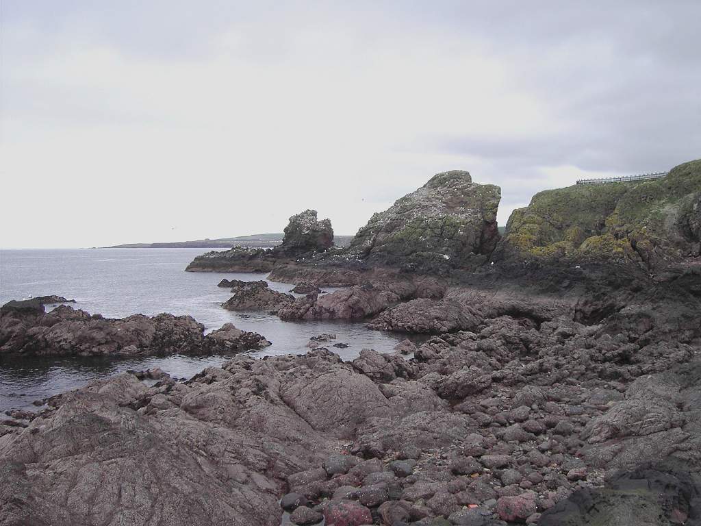 We were a trifle nervous about today’s Walk because it was the first of many we would tackle in Scotland where there are no paths marked on the OS map.
  Despite this, there was a clear signposted path leading up from the harbour to St Abbs Head, and a lot of people walking it (only the disabled are allowed to use the lighthouse road). Most of the other hikers were old codgers like us!
  The scenery was absolutely spectacular, the best we have seen so far on this Trek.
  What an introduction to Scotland!
 We sat on the grass overlooking these amazing cliffs to have the first part of our lunch.
We watched with amusement a couple turn off the path on to an almost vertical grassy slope to climb up for a better view. The woman was unhappy about the steepness of the slope, and they started arguing just like Colin and I do! He was most unhelpful, left her behind, and she had to scrabble up with great difficulty to get herself out of trouble. I kept nudging Colin, as we both recognised ourselves in that kind of silly exchange.
 There was a phenomenal amount of bird noise. It was mostly kittiwakes nesting on the cliff-face, but we did watch a shag take some seaweed up to its nest on a rock.
  We watched numerous gannets flying past out at sea.
  We got chatting to a Scottish couple who reckoned they come from Bass Rock and travel many miles each day in search of food. We climbed up past the lighthouse buildings to the very end — the view was breathtaking! We could see the twists and coils in the rocks. The coast turns a kind of ‘corner’ at this point, and the rest of our Walk today was almost due West.
It was also very lonely, as the rest of the world turned back to St Abbs whilst we carried on by ourselves.
 There were some signposts indicating a coastal path, but not nearly enough so they didn’t join up. There were some stiles, but mostly they didn’t lead anywhere — one took us over a fence into a crop field where it was impossible to proceed so we had to come out again!
  We found the vestige of a footpath every so often, but we think they were only sheep-tracks. There is no path marked on any map we have seen.
 We descended a very steep path to the lighthouse road, crossed a cattle grid and turned right on to the grass. We were almost at sea level, and there was a small stone quay that looked as if it might once have been a fishing harbour. No boats there now, in fact no buildings anywhere around so we concluded it is no longer used.
 We slowly climbed again to the top of a hill where there were some ‘Admiralty Distance Poles’ and sat down to have the rest of our lunch.
  There we planned tactics. We decided to stick to the contours as far as possible, since there was no path, in order to save needless climbing up and down. We made up a new rule about gullies:— “If we come to a steeply sided gully, we can walk round it on the relative flat rather than scramble down into the depths and have to climb out the other side.” (We had seen there were some hideously deep gullies coming up on the map!)
  We were really pleased to find most of the area was covered in short grass, so proceeding without a path was not too difficult.
We made towards a loch as the way looked easier by that route. In the distance a farmer on his quad-bike was herding a few cows. He called across to us, asking us to stop a few minutes until he had negotiated a field gateway because his cows were distracted by us.
 So we sat down until he had got them all safely in the field with the gate closed. Then he came across and thanked us for co-operating and apologised for holding us up. What a difference in attitude to our English farmers with all their ‘PRIVATE KEEP OUT’ notices!
We had a long chat, after all he was the only person we saw to talk to after St Abbs Head until the end of the day! He gave us a lot of helpful advice,
 and was impressed with our achievement on the Trek so far. He warned us to steer clear of gullies, he said if he loses a sheep in Dowlaw Dean, a couple of miles further on, he takes his lunch down there as he knows it is going to take all day! He said the authorities are trying to institute a coastal path between St Abbs and Cove, but it is not all worked out yet nor is much of it in place. Hence we came across the occasional signpost pointing to nowhere, and he warned us there may be the odd barbed wire fence to negotiate. He didn’t seem at all bothered that we were walking over his land, and wished us well with a cheery wave.
 We tried to keep to the contours without straying too far from the coast, and the going wasn’t too bad. When we came to field boundaries we mostly found a gate that opened. (We always carefully closed it behind us.) We only had to scale a couple of barbed wire fences — much more difficult these days with my back problem. The scenery was wonderful and the patches of gorse stood out with a yellow colour that was so bright it looked almost luminous.
 We skirted Westerside Dean and climbed up to a second set of ‘Admiralty Distance Poles’ which were exactly one mile, as the crow flies, from the first set. Ships out at sea line up the upper pole with the lower pole at each end and they have a measured mile, so they can set their instruments and control their speed.
As we walked along up high, Colin began to realise where he had gone wrong. Yesterday we had reccied out the route by driving from St Abbs up a tarmacked road to a farm called Lumsdaine, then driving in from the other end to a farm called Dowlaw where he had parked the car this morning.
 He turned down an offer of help from the lady who lives at Dowlaw because he thought it was a straight track just over a mile long which connected the two farms. But the track was far from straight. Near a little coppice he should have taken a sharp right turn, but he went straight on and found himself on the clifftop behind a locked gate. He lifted his bike over and continued eastwards where there is no path. With no map, he couldn’t do much else — no wonder he got himself into such a mess!
As we rounded a gully called Rough Heugh, Colin said, “I’ve been here before today!” We climbed over his locked gate and followed the track, which is absent from the OS map, to the coppice.
 That is where we worked out his mistake — if he’d had the map with him he could have returned from the locked gate and taken the correct track. So he has learned a lesson.
We didn’t go all the way along the trail to Dowlaw this afternoon as we wanted to hug the coast more. We just followed the track until we had passed the end of a long gully called Dowlaw Dean, then we turned towards the coast again and traversed some fields. We crossed several dribbles of streams, most narrow enough to jump over and one had a tiny stone arch bridge.

 That is where we saw some hares! Most of them ran off very fast as soon as we appeared, but one didn’t seem at all bothered and allowed us to get very close. Even when it knew we were there, it stayed put. We thought this very odd, and wondered if there was something wrong with the animal. But it looked quite healthy, so maybe there are so few people in the area it is not afraid of humans. Anyway, we were pleased to get some lovely photos.
 We walked round Telegraph Hill looking for the ruins of Fast Castle which are signposted from Dowlaw. We couldn’t find it! We thought we were in the right place. We looked very carefully at the map, relating the contours to the shape of the ground, but we couldn’t see any sign of a ruined castle.
  Admittedly we didn’t go right to the cliff edge because we were too tired to go down that steep slope only to have to climb back up again, so we could only conclude that if any remains exist they must be at the bottom of the cliff.
We had both reached that stage of tiredness when we couldn’t be bothered any more, so we trudged over Telegraph Hill (which had no signs of telegraph poles or anything like that on top of it) and found the track which led us alongside a thin wood to our car parked at Dowlaw. There were Soay sheep in a field opposite the car park. They are quite aggressive, and one of them stood her ground and stamped her feet when we went over to look at them.

That ended Walk no.150, we shall pick up Walk no.151 next time at Dowlaw Farm. It was twenty to six, so the Walk had taken us six hours. We were only about four miles from our cottage at Grantshouse, so we hadn’t bothered to make up a flask this morning. Instead, we changed out of our boots and drove straight ‘home’ so we could drink real tea (made with real tea leaves) in comfort.
Later Colin drove to St Abbs to pick up his bike while I cooked supper. He said the local inhabitants came out of their houses to talk to him while he was unlocking it. They had been quite concerned because his bike had been sitting there all day, they were wondering what had happened to its owner! Do you think we are being constantly watched as we do this Trek?

No comments:
Post a Comment