Ages: Colin was 65 years and 337 days. Rosemary was 63 years and 114 days.
Weather: Gloomy grey with occasional light rain. The wind had dropped so it was not nearly as cold. Around 4pm the sky suddenly cleared and it was sunny — lovely!
Location: Arbroath to Montrose.
Distance: 20 miles.
Total distance: 1440½ miles.
Terrain: Gravel paths, farm tracks, grassy paths, edges of newly sown crop fields, quiet tarmacked lanes and a little concrete. A bit undulating.
Tide: Coming in mostly, going out later.
Rivers: No.103, Lunan Water, which was too deep and fast-flowing to cross on the beach, the tide was too far in anyway. We went inland to a road and crossed on a bridge. No.104, Montrose Basin, where we finished the Walk by crossing it on the road bridge.
Ferries: None.
Piers: None.
Kissing gates: No.146 at Seaton Den. It had no ‘kiss’ (gate) but we had a kiss anyway!
Pub: None.
‘Historic Scotland’ properties: None.
Ferris wheels: None.
Diversions: None.
How we got there and back: We were staying in a holiday cottage in Montrose. We walked across the road to the station and caught a train to Arbroath. We then walked down to the harbour.
At the end, we walked the quarter mile from the bridge back to our holiday cottage. We didn’t use the car at all.
I was quite nervous about today’s Walk because it was so long — I have never walked twenty miles in my life before! The rain this morning didn’t help, but we had caught an earlier train than planned so we started the Walk at twenty to ten, which was good. I put off all the little voices inside me telling me not to go or to cut it short, and just got on with it. We could see Bell Rock Lighthouse, about which I wrote at length in the last chapter, very clearly today despite the dull skies and the drizzling rain.
 From the harbour in Arbroath, we took a road between houses and gardens and came out very soon on the seafront again. Strung up between us and the sea were a number of washing lines belonging to the cottages behind us. This was a phenomenon we were to come across in many villages up this East coast and along the North coast towards Inverness. The cottages usually have no private space around them¸ so the family
  washing is hung in the wind along the prom! I wonder if they originally hung it on fishing lines, and that is where the custom came from?
The next mile or so was a long thin car park under the low cliffs. At the end was a toilet block which was clean, open and free — full marks to the local Council! There were also two springs with stonework round them, so they had obviously been used as a source of fresh water in yesteryear. But each had a notice informing us that the water “is no longer fit for drinking”. Now, is it really polluted or is this ‘Health & Safety’ gone mad? Even our beautiful Malvern Water at home, the cleanest, loveliest spring water in the world, has notices at many of the springs advising us to boil the water before drinking!! So we are very dubious about such notices, are the authorities just covering their backs in these litigious days?
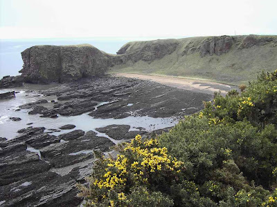
 The footpath from thereon is only marked spasmodically on the OS map, but we found that it was tarmacked as far as Carlingheugh Bay and then gravelled all the way to Auchmithie.
  It was a lovely path, and very easy to walk.
  The adjacent fields were intensively farmed right up to the path which was fenced off, so we had to walk round every single indentation of the coast.
  But we didn’t mind as the scenery was dramatic — red sandstone cliffs which have been eroded into all manner of gullies, arches, caves and stacks.
 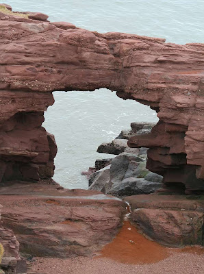 It was fantastic!
  It was a kittiwake haven, especially in the gullies where they were nesting on every conceivable ledge.
  They were very noisy!


 Some of the farming reminded us of the Fens, with acres of plastic sheeting and weird wire loops laid out across the fields. It is all very intensive, and more like a factory than the countryside. We went through an odd sort of ‘gate’ and couldn’t work out why it was shaped like that. I opined that it was some kind of obesity challenge — only short fat people could get through, not tall fat people! Colin said it was more like a hidden
  force-field, like they have in Star Trek! Then we stopped being silly and carried on with our Walk. The rain didn’t bother me as it was very light and spasmodic. Colin kept putting his umbrella up and taking it down yo-yo style. I ignored him.
We walked round Castlesea Bay, and there below us on the sand was the remains of a whale! It looked as if it had been there a long time. We couldn’t smell anything from where we were, and we didn’t go down to investigate in case it got too pongy! We intended to ask in the village about it, but by the time we got there we had forgotten about it — another sign of old age! So I looked it up on the internet after I got home, isn’t modern technology wonderful? Apparently it was a humpback whale that was only a calf. It had been tangled in nets and ropes which almost certainly led to its demise, and was already dead when it was washed up on the beach fourteen months ago. There was a report that it’s mother was spotted nearby also tangled in ropes, but then she was not seen again. The authorities didn’t know what to do about the eighteen foot carcass because the beach on which it lies is too remote to get heavy-lifting gear down there.
  A week later they were pleading with people, through the local newspaper, not to go near it in the interests of health & safety. Obviously they never did remove it because, fourteen months later, it is still there. Bet the smell was horrendous for a while!
 I felt sad when I found out it was a baby humpback because we have seen them in the wild. They are very playful — beautiful animals. In 1998 we went on a whale-watching trip in the Bay of Fundy, eastern Canada. The humpbacks came right up to the boat we were in, diving underneath it and waving their tails in the air! They were playing with us and showing off. It was very exciting! In 2003 we went on an Antarctic cruise where we had a number of sightings of humpbacks. On one memorable occasion, four adults confronted a pod of seventeen orcas — and won! Had a calf been present, an injured animal or a weakling, the outcome would have been very different. But four adults lined up together was just too much for the orcas, and at the last minute the killer whales dived underneath their huge adversaries and sped away.
 According to our OS map, the footpath follows the clifftop all the way to Auchmithie Harbour. But in actual fact it doesn’t. We had to cut off a corner and walk across to the back end of the village because the field was ploughed right to the edge of the cliff. The ‘pub’ in Auchmithie turned out to be a disappointment, for it was a posh restaurant and only allowed to sell alcohol with a meal. So we walked on past it and sat on a seat overlooking the tiny fishing harbour to eat our pies. There we chatted to a man from Mull who had lived all over the world. When his wife died, he didn’t feel like putting down roots anywhere. So he keeps moving on, still very restless now. He has seen some wonderful sights, and that is the only way he feels he can keep going.
 We passed the smokehouse, at least we thought that was what it was. For the ‘Arbroath Smokie’ was invented in Auchmithie. Legend tells us that a house in Auchmithie burned down, and when the tenants sifted through the ruins they found the charred remains of some herrings which they ate because they had nothing else. Much to their surprise, they tasted delicious — and so the ‘smokie’ was born! A nice story, but barely believable.
What is also unbelievable is that the fisherfolk of Auchmithie were still treated as serfs as late as 1830, but this story is true. That was the time when Arbroath was developing its fishing industry, and the Town Council enticed the fishing families of Auchmithie to move with promises of improved housing, higher pay and better working conditions. So the folk packed up their few belongings and walked to Arbroath along the cliff tops (bet they didn’t have nearly as nice a path as we have walked on today!) where they were received with open arms — for their skill at fishing under difficult conditions was well known. They settled in comfortably and were happy. But the Laird of Auchmithie was not! He took his case to court, stating that he ‘owned’ the fishing families of Auchmithie and he had not given his permission for them to go to Arbroath. He won his case, so these poor families had to return to their hovels and exploitation in Auchmithie even though they didn’t want to and had committed no crime! They were not free people, they were treated more like slaves.
 We had difficulty finding the onward path because of the plethora of “NO ADMITTANCE” and “PRIVATE DRIVE” notices in Auchmithie. This surprised us because Scotland has a much more open access policy than England. We realised there was no more coastal path, we would have to follow farm tracks, some of which led quite a long way inland. We found our way, and noticed we were walking towards a plume of
  black smoke. It was quite a big fire as we got near, so we asked the farmer who was attending it what he was burning. He told us he was getting rid of old carpets etc which fly-tippers had dumped in his woods. “No one else will remove them, so I have to do something about it myself!” We wondered what chemicals were being released into the atmosphere from those modern fibres, and we did think about the carbon footprint!
  But we didn’t mention any of this to the farmer because he was friendly and helpful towards us. He told us how we could get through to Lunan Bay, which was very useful information.
Colin found a couple of bird’s eggs which had been predated, the empty shells left on the track. We passed a farm where there were some strange black and white birds — not guinea fowl and certainly not chickens — we don’t know what they were. After Eathie Barns we reached the clifftop again. But what was the concrete structure that was originally barbed wired off? The original fencing had gone, and we couldn’t make it out at all. We sat nearby and ate our sandwiches.
After that the path was very vague, but at least there was one despite nothing being marked on the OS map. Once more we had fine views of magnificent scenery and hidden beaches. Sometimes we walked outside a broken wall, and sometimes we came inside it because the going got too dodgy on the clifftop. On one of the Heads we came across a collapsed pill box — it was all so long ago, as old as me! The farmer had left a green sward at the sides of the fields for a path, so we became quite confident that we would get through. Then we came to an electric fence, and we had to very carefully place ourselves on the correct side of it.


 We came to some newly planted corn fields, but again a green sward had been left along the sides for a path. The sun came out for a few moments, and mist was rising from the wet fields — it looked most weird. Further on the green sward disappeared, and we had no choice but to walk on the new plants. We didn’t want to, but there was nowhere else to go. Eventually we were able to climb over a wall, descend a steep bank
  and walk along a little road. We had reached Eathie Haven.
We accessed the beach past some wooden cabins where we chatted to a woman who was gardening. She had several children with her, and they looked happy and carefree in an old-fashioned way unlike our modern sophisticated children who are always bored. It was good to see.
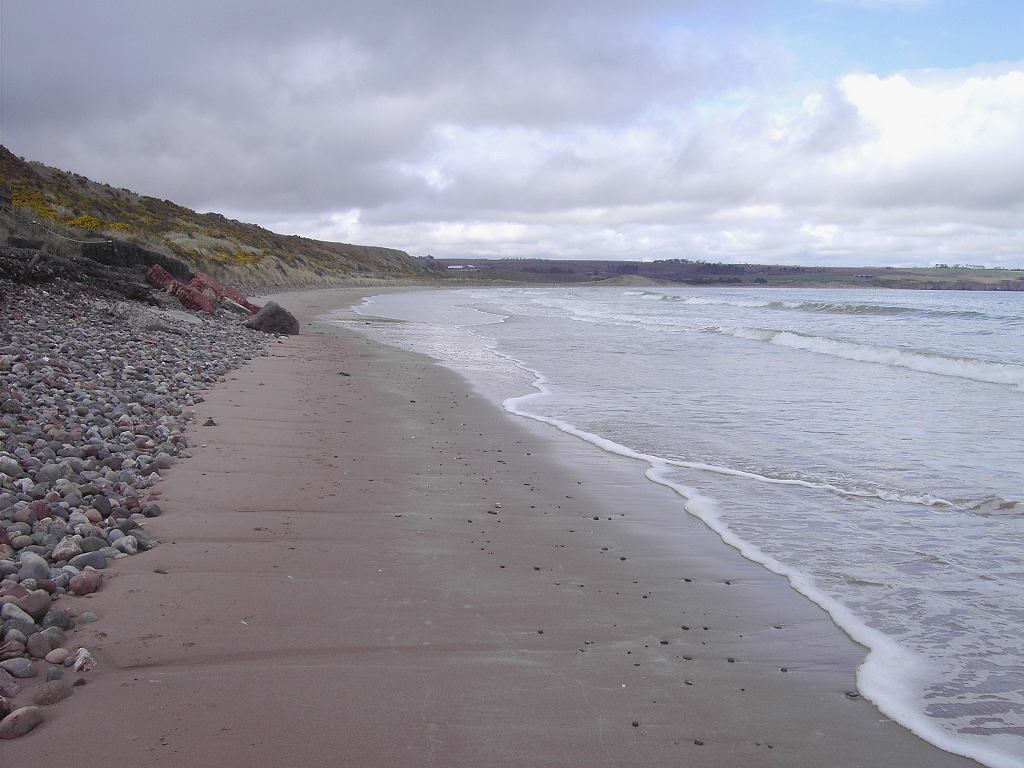
This was the best bit of the whole Walk — striding along the sands of Lunan Bay. The tide was well in, but there was still a strip of firm sand to walk on. We did enjoy it!
  We passed a collapsed building, and came across some sanderlings feeding at the water’s edge. It was idyllic!
 As we walked along the sky cleared and the sun came out. From the rain of this morning, it had turned into a beautiful day!
 Lunan Bay is about two miles long, but it has a river running across it at about the halfway point. If the tide had been very low we could possibly have got across the shallow braids, but the tide was completely wrong. There was no way we could get across that fast-flowing river without a bridge, it was much too deep. I sat on a concrete block to work out what to do, and a wave brought water swirling around my feet. I had to
  move pretty sharpish! We found a dry rock to sit on and eat our apples. A ruined castle towered above us. When we looked at the bit that was left we thought it looked like the head of a unicorn!
We made the unpopular decision to do a few miles of road-walking. Time was getting on and we still had a long way to go. We didn’t know what the footpath situation was further on (none was marked on the map), the contours were pretty close together, there were more gullies to negotiate and a railway line runs very close to the cliff edge. So we back-tracked a little to skirt round the ruined castle and some houses, and get out on to the road. We both hate road-walking, so we ‘route-marched’ for the next four miles to get that ‘nasty’ bit of the Walk over as quickly as possible. Our only saving grace was the beautiful blossom we passed on the way, as it is that special time of year.

 We came to Usan. In this hamlet we took a track which crossed two fields and then stopped — according to the map but in actual fact it did what we were hoping and continued to the sea. It was a bit muddy, but obviously well used by locals. From there the contours were widely spaced, and further on a path was marked. When we got to the rocks we sat down and ate our chocolate. Colin didn’t really eat the whole bar at once, but he felt like it because we were getting tired. The sun was already getting quite low causing long shadows to form. We were hoping we would get to Montrose before it got dark.

 We walked along rough grass towards the lighthouse which seemed to be a long way away. It was not really a path, but quite walkable. We came to a rusty winch, then to some ruined buildings including a mausoleum! Its date suggested it was about two hundred years old.
  There were some derelict ponds there too. We don’t know what it used to be, but we found it difficult to get past. We walked round the whole complex and through a gate, then suddenly we were free!
  The lighthouse still seemed just as far away! Yes, we were getting really tired.
It was another mile to the lighthouse, by which time it was beginning to get dark. We skirted round it and followed the lighthouse road for two miles alongside the river. By now it was quite dark, good thing we were in an area of street lights. Montrose looked very industrial from that side of the river. Through Ferrydene to the roundabout where a lorry driver stopped and asked us how far it was to Stonehaven — we hadn’t a clue! Across the bridge, and our Walk was done. We had walked twenty miles, and we are both in our sixties! We felt elated and very proud of ourselves.
That ended Walk no.171, we shall pick up Walk no.172 next time just over the bridge in Montrose. It was a twenty to eight, so the Walk had taken us ten hours. We were only a quarter of a mile from our holiday cottage, so we were soon back drinking tea, and I had a long soak in the bath before we had a late dinner.
Weather: Gloomy grey with occasional light rain. The wind had dropped so it was not nearly as cold. Around 4pm the sky suddenly cleared and it was sunny — lovely!
Location: Arbroath to Montrose.
Distance: 20 miles.
Total distance: 1440½ miles.
Terrain: Gravel paths, farm tracks, grassy paths, edges of newly sown crop fields, quiet tarmacked lanes and a little concrete. A bit undulating.
Tide: Coming in mostly, going out later.
Rivers: No.103, Lunan Water, which was too deep and fast-flowing to cross on the beach, the tide was too far in anyway. We went inland to a road and crossed on a bridge. No.104, Montrose Basin, where we finished the Walk by crossing it on the road bridge.
Ferries: None.
Piers: None.
Kissing gates: No.146 at Seaton Den. It had no ‘kiss’ (gate) but we had a kiss anyway!
Pub: None.
‘Historic Scotland’ properties: None.
Ferris wheels: None.
Diversions: None.
How we got there and back: We were staying in a holiday cottage in Montrose. We walked across the road to the station and caught a train to Arbroath. We then walked down to the harbour.
At the end, we walked the quarter mile from the bridge back to our holiday cottage. We didn’t use the car at all.
I
 was quite nervous about today’s Walk because it was so long — I have never walked twenty miles in my life before! The rain this morning didn’t help, but we had caught an earlier train than planned so we started the Walk at twenty to ten, which was good. I put off all the little voices inside me telling me not to go or to cut it short, and just got on with it. We could see Bell Rock Lighthouse, about which I wrote at length in the last chapter, very clearly today despite the dull skies and the drizzling rain.
 From the harbour in Arbroath, we took a road between houses and gardens and came out very soon on the seafront again. Strung up between us and the sea were a number of washing lines belonging to the cottages behind us. This was a phenomenon we were to come across in many villages up this East coast and along the North coast towards Inverness. The cottages usually have no private space around them¸ so the family
  washing is hung in the wind along the prom! I wonder if they originally hung it on fishing lines, and that is where the custom came from?
The next mile or so was a long thin car park under the low cliffs. At the end was a toilet block which was clean, open and free — full marks to the local Council!
 There were also two springs with stonework round them, so they had obviously been used as a source of fresh water in yesteryear. But each had a notice informing us that the water “is no longer fit for drinking”. Now, is it really polluted or is this ‘Health & Safety’ gone mad? Even our beautiful Malvern Water at home, the cleanest, loveliest spring water in the world, has notices at many of the springs advising us to boil the water before drinking!! So we are very dubious about such notices, are the authorities just covering their backs in these litigious days?
 The footpath from thereon is only marked spasmodically on the OS map, but we found that it was tarmacked as far as Carlingheugh Bay and then gravelled all the way to Auchmithie.
  It was a lovely path, and very easy to walk.
  The adjacent fields were intensively farmed right up to the path which was fenced off, so we had to walk round every single indentation of the coast.
  But we didn’t mind as the scenery was dramatic — red sandstone cliffs which have been eroded into all manner of gullies, arches, caves and stacks.
  It was fantastic!
  It was a kittiwake haven, especially in the gullies where they were nesting on every conceivable ledge.
  They were very noisy!


 Some of the farming reminded us of the Fens, with acres of plastic sheeting and weird wire loops laid out across the fields. It is all very intensive, and more like a factory than the countryside. We went through an odd sort of ‘gate’ and couldn’t work out why it was shaped like that. I opined that it was some kind of obesity challenge — only short fat people could get through, not tall fat people! Colin said it was more like a hidden
  force-field, like they have in Star Trek! Then we stopped being silly and carried on with our Walk. The rain didn’t bother me as it was very light and spasmodic. Colin kept putting his umbrella up and taking it down yo-yo style. I ignored him.
We walked round Castlesea Bay, and there below us on the sand was the remains of a whale! It looked as if it had been there a long time. We couldn’t smell anything from where we were, and we didn’t go down to investigate in case it got too pongy! We intended to ask in the village about it, but by the time we got there we had forgotten about it — another sign of old age! So I looked it up on the internet after I got home, isn’t modern technology wonderful? Apparently it was a
 humpback whale that was only a calf. It had been tangled in nets and ropes which almost certainly led to its demise, and was already dead when it was washed up on the beach fourteen months ago. There was a report that it’s mother was spotted nearby also tangled in ropes, but then she was not seen again. The authorities didn’t know what to do about the eighteen foot carcass because the beach on which it lies is too remote to get heavy-lifting gear down there.
  A week later they were pleading with people, through the local newspaper, not to go near it in the interests of health & safety. Obviously they never did remove it because, fourteen months later, it is still there. Bet the smell was horrendous for a while!
 I felt sad when I found out it was a baby humpback because we have seen them in the wild. They are very playful — beautiful animals. In 1998 we went on a whale-watching trip in the Bay of Fundy, eastern Canada. The humpbacks came right up to the boat we were in, diving underneath it and waving their tails in the air! They were playing with us and showing off. It was very exciting! In 2003 we went on an Antarctic cruise where we had a number of sightings of humpbacks. On one memorable occasion, four adults confronted a pod of seventeen orcas — and won! Had a calf been present, an injured animal or a weakling, the outcome would have been very different. But four adults lined up together was just too much for the orcas, and at the last minute the killer whales dived underneath their huge adversaries and sped away.
 According to our OS map, the footpath follows the clifftop all the way to Auchmithie Harbour. But in actual fact it doesn’t. We had to cut off a corner and walk across to the back end of the village because the field was ploughed right to the edge of the cliff. The ‘pub’ in Auchmithie turned out to be a disappointment, for it was a posh restaurant and only allowed to sell alcohol with a meal. So we walked on past it and sat on a seat overlooking the tiny fishing harbour to eat our pies. There we chatted to a man from Mull who had lived all over the world. When his wife died, he didn’t feel like putting down roots anywhere. So he keeps moving on, still very restless now. He has seen some wonderful sights, and that is the only way he feels he can keep going.
 We passed the smokehouse, at least we thought that was what it was. For the ‘Arbroath Smokie’ was invented in Auchmithie. Legend tells us that a house in Auchmithie burned down, and when the tenants sifted through the ruins they found the charred remains of some herrings which they ate because they had nothing else. Much to their surprise, they tasted delicious — and so the ‘smokie’ was born! A nice story, but barely believable.
What is also unbelievable is that the fisherfolk of Auchmithie were still treated as serfs as late as 1830, but this story is true. That was the time when Arbroath was developing its fishing industry, and the Town Council enticed the fishing families of Auchmithie to move with promises of improved housing, higher pay and better working conditions. So the folk packed up their few belongings and walked to Arbroath along the cliff tops (bet they didn’t have nearly as nice a path as we have walked on today!) where they were received with open arms — for their skill at fishing under difficult conditions was well known. They settled in comfortably and were happy. But the Laird of Auchmithie was not! He took his case to court, stating that he ‘owned’ the fishing families of Auchmithie and he had not given his permission for them to go to Arbroath. He won his case, so these poor families had to return to their hovels and exploitation in Auchmithie even though they didn’t want to and had committed no crime! They were not free people, they were treated more like slaves.
 We had difficulty finding the onward path because of the plethora of “NO ADMITTANCE” and “PRIVATE DRIVE” notices in Auchmithie. This surprised us because Scotland has a much more open access policy than England. We realised there was no more coastal path, we would have to follow farm tracks, some of which led quite a long way inland. We found our way, and noticed we were walking towards a plume of
  black smoke. It was quite a big fire as we got near, so we asked the farmer who was attending it what he was burning. He told us he was getting rid of old carpets etc which fly-tippers had dumped in his woods. “No one else will remove them, so I have to do something about it myself!” We wondered what chemicals were being released into the atmosphere from those modern fibres, and we did think about the carbon footprint!
  But we didn’t mention any of this to the farmer because he was friendly and helpful towards us. He told us how we could get through to Lunan Bay, which was very useful information.
Colin found a couple of bird’s eggs which had been predated, the empty shells left on the track. We passed a farm where there were some strange black and white birds — not guinea fowl and certainly
 not chickens — we don’t know what they were. After Eathie Barns we reached the clifftop again. But what was the concrete structure that was originally barbed wired off? The original fencing had gone, and we couldn’t make it out at all. We sat nearby and ate our sandwiches.
After that the path was very vague, but at least there was one despite nothing being marked on the
 OS map. Once more we had fine views of magnificent scenery and hidden beaches. Sometimes we walked outside a broken wall, and sometimes we came inside it because the going got too dodgy on the clifftop. On one of the Heads we came across a collapsed pill box — it was all so long ago, as old as me! The farmer had left a green sward at the sides of the fields for a path, so we became quite confident that we would get through. Then we came to an electric fence, and we had to very carefully place ourselves on the correct side of it.


 We came to some newly planted corn fields, but again a green sward had been left along the sides for a path. The sun came out for a few moments, and mist was rising from the wet fields — it looked most weird. Further on the green sward disappeared, and we had no choice but to walk on the new plants. We didn’t want to, but there was nowhere else to go. Eventually we were able to climb over a wall, descend a steep bank
  and walk along a little road. We had reached Eathie Haven.
We accessed the beach past some wooden cabins where we chatted to a woman who was gardening. She had several children with her, and they looked happy and carefree in an old-fashioned way unlike our modern sophisticated children who are always bored. It was good to see.
This was the best bit of the whole Walk — striding along the sands of Lunan Bay.
 The tide was well in, but there was still a strip of firm sand to walk on. We did enjoy it!
  We passed a collapsed building, and came across some sanderlings feeding at the water’s edge. It was idyllic!
 As we walked along the sky cleared and the sun came out. From the rain of this morning, it had turned into a beautiful day!
 Lunan Bay is about two miles long, but it has a river running across it at about the halfway point. If the tide had been very low we could possibly have got across the shallow braids, but the tide was completely wrong. There was no way we could get across that fast-flowing river without a bridge, it was much too deep. I sat on a concrete block to work out what to do, and a wave brought water swirling around my feet. I had to
  move pretty sharpish! We found a dry rock to sit on and eat our apples. A ruined castle towered above us. When we looked at the bit that was left we thought it looked like the head of a unicorn!
We made the unpopular decision to do a few miles of road-walking. Time was getting on and we still had a long way to go. We didn’t know what the footpath situation was further on (none was marked
 on the map), the contours were pretty close together, there were more gullies to negotiate and a railway line runs very close to the cliff edge. So we back-tracked a little to skirt round the ruined castle and some houses, and get out on to the road. We both hate road-walking, so we ‘route-marched’ for the next four miles to get that ‘nasty’ bit of the Walk over as quickly as possible. Our only saving grace was the beautiful blossom we passed on the way, as it is that special time of year.
 We came to Usan. In this hamlet we took a track which crossed two fields and then stopped — according to the map but in actual fact it did what we were hoping and continued to the sea. It was a bit muddy, but obviously well used by locals. From there the contours were widely spaced, and further on a path was marked. When we got to the rocks we sat down and ate our chocolate. Colin didn’t really eat the whole bar at once, but he felt like it because we were getting tired. The sun was already getting quite low causing long shadows to form. We were hoping we would get to Montrose before it got dark.
 We walked along rough grass towards the lighthouse which seemed to be a long way away. It was not really a path, but quite walkable. We came to a rusty winch, then to some ruined buildings including a mausoleum! Its date suggested it was about two hundred years old.
  There were some derelict ponds there too. We don’t know what it used to be, but we found it difficult to get past. We walked round the whole complex and through a gate, then suddenly we were free!
  The lighthouse still seemed just as far away! Yes, we were getting really tired.
It was another mile to the lighthouse, by which time it was beginning to get dark. We skirted round it and followed the lighthouse road for two miles alongside the river. By now it was quite dark, good thing we were in an area of street lights. Montrose looked very industrial from that side of the river. Through Ferrydene to the roundabout where a lorry driver stopped and asked us how far it was to Stonehaven — we hadn’t a clue! Across the bridge, and our Walk was done. We had walked twenty miles, and we are both in our sixties! We felt elated and very proud of ourselves.

That ended Walk no.171, we shall pick up Walk no.172 next time just over the bridge in Montrose. It was a twenty to eight, so the Walk had taken us ten hours. We were only a quarter of a mile from our holiday cottage, so we were soon back drinking tea, and I had a long soak in the bath before we had a late dinner.


No comments:
Post a Comment