Ages: Colin was 65 years and 339 days. Rosemary was 63 years and 116 days.
Weather: Mostly sunny with a light cold breeze. Occasional light showers, but they never came to much.
Location: Montrose to Johnshaven.
Distance: 12½ miles.
Total distance: 1453 miles.
Terrain: Concrete. Firm sandy beach. Grassy/muddy paths. Roads. Dunes. Grassy cliff paths. Pebbly beaches. Flat at first, then undulating.
Tide: Out, coming in later.
Rivers: No.105, River North Esk, which was too deep and fast-flowing to cross on the beach though we did consider it. We decided it wasn’t worth the risk, and walked a mile inland so we could cross it on an old railway viaduct. No.106, Woodston Burn, which we crossed using a footbridge. No.107, St James’s Burn, which we crossed by a footbridge just before a caravan site.
Ferries: None.
Piers: None.
Kissing gates: None.
Pub: None.
‘Historic Scotland’ properties: None.
Ferris wheels: None.
Diversions: None.
How we got there and back: We were staying in a holiday cottage in Montrose. Colin drove to Johnshaven, parked the car by the harbour and caught a bus back to Montrose. Meanwhile I made our sandwiches. When he returned we walked down the road to the bridge where we finished the last Walk.
At the end, we walked right up to the car parked on the harbour edge in Johnshaven. We had a cup of tea, and returned to our holiday cottage.
 As we stood at the end of the bridge in Montrose at the spot where we finished the last Walk, we watched three huge lorries drive past. Each had a single enormous tank on its back, and we wondered if they were bound for the oil terminal at Aberdeen. Such big traffic for an ordinary-sized two-way road through a town!
A few yards into the Walk, along the northern bank of the river which drains Montrose Basin, we came across two memorial statues. One is called ‘The Seafarer’, and is a memorial to the seamen and fishermen of Montrose and Ferryden, and a tribute to William Lamb who was a native of the town and a renowned sculptor. The other is a memorial to a dog! But no ordinary dog, this. Bamse, Norwegian for ‘Teddy Bear’, was a St Bernard dog that was an official member of the crew of the Norwegian minesweeper ‘Thorodd’ during the Second World War. It was the family pet of the Captain of that vessel, and used to stand on the front gun tower of the ship.
The crew became very attached to him, and made him a metal helmet of his own. His exploits soon became legendary. He is attributed with saving a young lieutenant commander’s life by pushing him into the sea when he was attacked by a man wielding a knife, with dragging to shore a sailor who had fallen overboard, with breaking up fights amongst his fellow crew members by putting his paws on their shoulders and calming them down, and escorting them back from their ‘watering holes’ so they did not break the curfew. To do this he sometimes had to travel by bus, so he even had his own bus pass in a see-through wallet around his neck!
When he died of natural causes in 1944 aged only seven, he was buried in the sand dunes at Montrose with full military honours. He was already the official mascot of the Royal Norwegian Navy, and later of all Free Norwegian Forces. The PDSA made him an official Allied Forces Mascot. In 1984 the Norwegians awarded him a posthumous ‘Norges Hundeorden’ for gallantry and devotion to duty. In 2006 the PDSA awarded him their Gold Medal, sometimes called the animal’s George Cross. That is when the statue was sculpted, and unveiled by Prince Andrew.
The road soon took us away from the riverside, for this is a highly industrialised area. Some places looked busy, but we came across a huge warehouse which was derelict and obviously due for demolition. We came down to the beach next to the high fence of the GlaxoSmithKline factory. (My uncle, a chemist, was employed by Glaxo all his working life and they sponsored our son, Paul, for his PhD studies so we didn’t have to pay for them. I quite like the firm!)

 There we were in a different world! The most beautiful firm sandy beach stretched before us. The sun was shining and it looked stunning! So we tried to ignore the bitterly cold wind and started walking northwards on it. It was a glorious couple of hours until we reached the river, three miles or so further on. Part way, we sat on a sand dune and ate our pasties.
We read a board which told us that we have GlaxoSmithKline to thank for the beautiful beach we were walking on. In 1997 they calculated, with the current rate of erosion, that they had a mere five years before their whole Works would be engulfed by the sea! So they invested £2.5million in strengthening the sea defences. Three groynes were constructed using 50 000 tonnes of rock. This was quarried in Norway and transported by sea directly to the site. Then 100 000 tonnes of sand was dredged from the mouth of the adjacent River South Esk and used to build up the beach over the groynes. They showed us with diagrams how this was done, and we could see the work was still ongoing.
  It is hoped the raised beach level will reduce the pounding of the waves during stormy times, and act as a buffer. Whatever, they have constructed a simply wonderful beach! The tide was right out, and we seemed to be the only people about once we had got past the town. We also saw the remains of concrete Second World War defences further along the beach — now looking very small and somehow sorry for themselves. So many miles of concrete desecrate our beaches due to Conflict, I wonder what the beaches were like before concrete was invented!


 We came to the river, but did not go right out to the sandy point. We discussed wading across to save distance, as the tide was right out and the river was braided. But looking at it we realised it was much too deep and the current looked quite strong, so we turned and walked a mile upstream to the bridges. It would have saved us a couple of miles if we could have done it, but it wasn’t worth a
  couple of lives! We crossed what was marked as a ford on the map, but it proved to be a low wooden bridge. Next there was no path according to the map, and we weren’t sure if we could walk beside the river. But in reality there was a lovely path, partially through woods, and we had no difficulty getting through. It is very frustrating that Ordnance Survey are so very out-of-date about Scottish footpaths — these are
  supposed to be up-to-date maps, they cost enough!
The River North Esk is crossed by two viaducts — an old railway bridge, now a cycle track/footpath, and a road bridge. We caught sight of them through the trees, and they looked very graceful! The railway viaduct particularly, but the railway has long since gone. A foundation stone told us that the road bridge was opened in 1775. Another stone told us a little of the history of this bridge. In fancy writing it begins, “Travellers / Pass safe and free / Along this BRIDGE / Built by Subscription / To which the Town of MONTROSE / And the two adjacent Counties / Contributed a large Share” and it went on at length about how the Provost of Montrose, one Thomas Christie, directed a ‘liberal sum’ to be given — but he died before his subscription could be ‘opened’. Fortunately his eldest son was an
  ‘active and public spirited citizen’ who carried on where his father left off. And so the inscription went on…and on…as they did in that day and age — but they didn’t reckon on a 21st century ‘Armco’ barrier being built in front of it so we couldn’t read the bottom bit! The upshot of it was that the bridge was opened in 1775 — but we already knew that from the much shorter inscription on the other foundation stone!
 The higher railway viaduct was built ninety years later, in 1865. It seems ironic that the last train rattled across it in 1951, yet constant traffic still flows across the older road bridge. This east-coast railway finally closed in 1966, and the viaduct was designated an official cycleway/footpath in 2002. Having gleaned all this information, we climbed up on to the ex-railway viaduct and walked across from Angus to Aberdeenshire. Then we couldn’t see how to get down to the nature reserve road which ran underneath. We had to spiral round, but none of this was marked on the map. Nil points to the Ordnance Survey!


 We passed a field with ponies grazing. On of them was a Shetland pony, no bigger than a dog!
  Then we passed two geese in a ditch. They went for Colin, they really didn’t like him but backed off when Colin hissed back! In another field a coated horse was running round, and it struck us that it looked just like a pantomime horse!
All the while we were looking for somewhere to stop and eat our sandwiches, for we were quite hungry by then. But there was nowhere to sit down, and the wind was really cold despite the sun. We came to the nature reserve Visitor Centre. It was open but unmanned. We looked round the exhibition on the ground floor and took a photo of a fish in a tank. Then we went upstairs to a small glassed-in viewing platform overlooking the dunes and a pool. There were two chairs up there, and we were completely on our own. So we sat down and ate our lunch in the warm with a beautiful view! Perfick!


 We were reluctant to leave, it was cold outside! We could have crossed the dunes to the beach again, but we were tired so we decided to follow the grassy path along the bottom of the grassy cliffs because it was easier. The gorse was in full flower and looked stunning in the sunshine. We passed an old cemetery, but didn’t go in.
 We came to the end of the beach where the path led us gently up on to the cliffs — again this was not at all clear from the map.


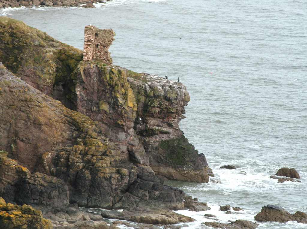
 There was a narrow path which led on along the top of the cliffs. We followed this down a gully, up the other side, and past a ruined castle (not much left) where we saw a number of interesting birds on the rocks.


 We came to a road, and got a bit confused because we no longer had any trust in the map. There was a sculpture (at least we think that’s what it was) in the garden of a cottage but we couldn’t work out what it was supposed to be. We decided we couldn’t get round the headland and would have to go inland on the road for a little way. After half a mile or so we got back to a pebbly beach and were able to walk along that. It was really cold.
 Between us and the grassy cliffs was a greensward, and that is where we saw some deer who soon skittered off. We passed a ruined cottage, and sat on the wall of an open boatyard to eat our chocolate.
  By now the tide was well in leaving only a narrow strip of beach. The weather had turned grey and we don’t like pebbly beaches. But I think it was the cold wind that made us feel down, I can never be cheerful if I am cold.
A grassy path now appeared on a low bank, that was an improvement. We crossed a stream just before a caravan site, then
 turned into the site to avoid more pebbly beach. The path was very muddy for a while, then it improved. The shoreline became quite rocky with interesting and different formations, but the path remained smooth and easy to follow. We saw a heron fishing in the shallows, and lots of gulls.
 At one point the path seemed to cut through the rocks in a spectacular fashion, and then we came across some ancient lime kilns.
  I am puzzled about this because, looking at the Geology map of the area, we were walking across Devonian Old Red Sandstone with Andesitic Tuffs and Basaltic Lavas (that’s ancient volcanic rocks) and not a limestone anywhere.
  There’s clearly a lot I need still to learn about Geology!
  Whatever, the coast was very pretty.

 We
We  came to the first houses of Johnshaven, one of which was roofless, and the path turned into a track, then became a road. We walked the length of the south-western arm of the harbour, and then came upon our car parked at the centre.

That ended Walk no.172, we shall pick up Walk no.173 next time at the harbour’s edge in Johnshaven. It was a five past six, so the Walk had taken us seven and a half hours. We had a cup of tea, then returned to our cottage in Montrose.
Location: Montrose to Johnshaven.
Distance: 12½ miles.
Total distance: 1453 miles.
Terrain: Concrete. Firm sandy beach. Grassy/muddy paths. Roads. Dunes. Grassy cliff paths. Pebbly beaches. Flat at first, then undulating.
Tide: Out, coming in later.
Rivers: No.105, River North Esk, which was too deep and fast-flowing to cross on the beach though we did consider it. We decided it wasn’t worth the risk, and walked a mile inland so we could cross it on an old railway viaduct. No.106, Woodston Burn, which we crossed using a footbridge. No.107, St James’s Burn, which we crossed by a footbridge just before a caravan site.
Ferries: None.
Piers: None.
Kissing gates: None.
Pub: None.
‘Historic Scotland’ properties: None.
Ferris wheels: None.
Diversions: None.
How we got there and back: We were staying in a holiday cottage in Montrose. Colin drove to Johnshaven, parked the car by the harbour and caught a bus back to Montrose. Meanwhile I made our sandwiches. When he returned we walked down the road to the bridge where we finished the last Walk.
At the end, we walked right up to the car parked on the harbour edge in Johnshaven. We had a cup of tea, and returned to our holiday cottage.
 As we stood at the end of the bridge in Montrose at the spot where we finished the last Walk, we watched three huge lorries drive past. Each had a single enormous tank on its back, and we wondered if they were bound for the oil terminal at Aberdeen. Such big traffic for an ordinary-sized two-way road through a town!
A few yards into the Walk, along the northern bank of the river which drains Montrose Basin, we came across two memorial statues. One is called ‘The Seafarer’, and is a memorial to the seamen and fishermen of Montrose and Ferryden, and a tribute to William Lamb who was a native of the town and a renowned sculptor. The other is a memorial to a dog! But no ordinary dog, this.
 Bamse, Norwegian for ‘Teddy Bear’, was a St Bernard dog that was an official member of the crew of the Norwegian minesweeper ‘Thorodd’ during the Second World War. It was the family pet of the Captain of that vessel, and used to stand on the front gun tower of the ship.
The crew became very attached to him, and made him a metal helmet of his own. His exploits soon became legendary. He is attributed with saving a young lieutenant commander’s life by pushing him into the sea when he was attacked by a man wielding a knife, with dragging to shore a sailor who had fallen overboard, with breaking up fights amongst his fellow crew members by putting his paws on their shoulders and calming them
 down, and escorting them back from their ‘watering holes’ so they did not break the curfew. To do this he sometimes had to travel by bus, so he even had his own bus pass in a see-through wallet around his neck!
When he died of natural causes in 1944 aged only seven, he was buried in the sand dunes at Montrose with full military honours. He was already the official mascot of the Royal Norwegian Navy, and later of all Free Norwegian Forces. The PDSA made him an official Allied Forces Mascot. In 1984 the Norwegians awarded him a posthumous ‘Norges Hundeorden’ for gallantry and devotion to duty. In 2006 the PDSA awarded him their Gold Medal, sometimes called the animal’s George Cross. That is when the
 statue was sculpted, and unveiled by Prince Andrew.
The road soon took us away from the riverside, for this is a highly industrialised area. Some places looked busy, but we came across a huge warehouse which was derelict and obviously due for demolition. We came down to the beach next to the high fence of the GlaxoSmithKline factory. (My uncle, a chemist, was employed by Glaxo all his working life and they sponsored our son, Paul, for his PhD studies so we didn’t have to pay for them. I quite like the firm!)

 There we were in a different world! The most beautiful firm sandy beach stretched before us. The sun was shining and it looked stunning! So we tried to ignore the bitterly cold wind and started walking northwards on it. It was a glorious couple of hours until we reached the river, three miles or so further on. Part way, we sat on a sand dune and ate our pasties.
We read a board which told us that we have GlaxoSmithKline to thank for the beautiful beach we were walking on. In 1997 they calculated, with the current rate of erosion, that they had a mere
 five years before their whole Works would be engulfed by the sea! So they invested £2.5million in strengthening the sea defences. Three groynes were constructed using 50 000 tonnes of rock. This was quarried in Norway and transported by sea directly to the site. Then 100 000 tonnes of sand was dredged from the mouth of the adjacent River South Esk and used to build up the beach over the groynes. They showed us with diagrams how this was done, and we could see the work was still ongoing.
  It is hoped the raised beach level will reduce the pounding of the waves during stormy times, and act as a buffer. Whatever, they have constructed a simply wonderful beach! The tide was right out, and we seemed to be the only people about once we had got past the town. We also saw the remains of concrete Second World War defences further along the beach — now looking very small and somehow sorry for themselves. So many miles of concrete desecrate our beaches due to Conflict, I wonder what the beaches were like before concrete was invented!

 We came to the river, but did not go right out to the sandy point. We discussed wading across to save distance, as the tide was right out and the river was braided. But looking at it we realised it was much too deep and the current looked quite strong, so we turned and walked a mile upstream to the bridges. It would have saved us a couple of miles if we could have done it, but it wasn’t worth a
  couple of lives! We crossed what was marked as a ford on the map, but it proved to be a low wooden bridge. Next there was no path according to the map, and we weren’t sure if we could walk beside the river. But in reality there was a lovely path, partially through woods, and we had no difficulty getting through. It is very frustrating that Ordnance Survey are so very out-of-date about Scottish footpaths — these are
  supposed to be up-to-date maps, they cost enough!
The River North Esk is crossed by two viaducts — an old railway bridge, now a cycle track/footpath, and a road bridge. We caught sight of them through the trees, and they looked very graceful! The railway viaduct particularly, but the railway has long since gone. A foundation stone told us that the road bridge was opened in 1775. Another stone told us a little of the
 history of this bridge. In fancy writing it begins, “Travellers / Pass safe and free / Along this BRIDGE / Built by Subscription / To which the Town of MONTROSE / And the two adjacent Counties / Contributed a large Share” and it went on at length about how the Provost of Montrose, one Thomas Christie, directed a ‘liberal sum’ to be given — but he died before his subscription could be ‘opened’. Fortunately his eldest son was an
  ‘active and public spirited citizen’ who carried on where his father left off. And so the inscription went on…and on…as they did in that day and age — but they didn’t reckon on a 21st century ‘Armco’ barrier being built in front of it so we couldn’t read the bottom bit! The upshot of it was that the bridge was opened in 1775 — but we already knew that from the much shorter inscription on the other foundation stone!
 The higher railway viaduct was built ninety years later, in 1865. It seems ironic that the last train rattled across it in 1951, yet constant traffic still flows across the older road bridge. This east-coast railway finally closed in 1966, and the viaduct was designated an official cycleway/footpath in 2002. Having gleaned all this information, we climbed up on to the ex-railway viaduct and walked across from Angus to Aberdeenshire. Then we couldn’t see how to get down to the nature reserve road which ran underneath. We had to spiral round, but none of this was marked on the map. Nil points to the Ordnance Survey!


 We passed a field with ponies grazing. On of them was a Shetland pony, no bigger than a dog!
  Then we passed two geese in a ditch. They went for Colin, they really didn’t like him but backed off when Colin hissed back! In another field a coated horse was running round, and it struck us that it looked just like a pantomime horse!
All the while we were looking for somewhere to stop and eat our sandwiches, for we were quite hungry by then. But there was nowhere to sit down, and the wind was really cold despite the sun.
 We came to the nature reserve Visitor Centre. It was open but unmanned. We looked round the exhibition on the ground floor and took a photo of a fish in a tank. Then we went upstairs to a small glassed-in viewing platform overlooking the dunes and a pool. There were two chairs up there, and we were completely on our own. So we sat down and ate our lunch in the warm with a beautiful view! Perfick!

 We were reluctant to leave, it was cold outside! We could have crossed the dunes to the beach again, but we were tired so we decided to follow the grassy path along the bottom of the grassy cliffs because it was easier. The gorse was in full flower and looked stunning in the sunshine. We passed an old cemetery, but didn’t go in.
 We came to the end of the beach where the path led us gently up on to the cliffs — again this was not at all clear from the map.


 There was a narrow path which led on along the top of the cliffs. We followed this down a gully, up the other side, and past a ruined castle (not much left) where we saw a number of interesting birds on the rocks.

 We came to a road, and got a bit confused because we no longer had any trust in the map. There was a sculpture (at least we think that’s what it was) in the garden of a cottage but we couldn’t work out what it was supposed to be. We decided we couldn’t get round the headland and would have to go inland on the road for a little way. After half a mile or so we got back to a pebbly beach and were able to walk along that. It was really cold.
 Between us and the grassy cliffs was a greensward, and that is where we saw some deer who soon skittered off. We passed a ruined cottage, and sat on the wall of an open boatyard to eat our chocolate.
  By now the tide was well in leaving only a narrow strip of beach. The weather had turned grey and we don’t like pebbly beaches. But I think it was the cold wind that made us feel down, I can never be cheerful if I am cold.
A grassy path now appeared on a low bank, that was an improvement.
 We crossed a stream just before a caravan site, then
 turned into the site to avoid more pebbly beach. The path was very muddy for a while, then it improved. The shoreline became quite rocky with interesting and different formations, but the path remained smooth and easy to follow. We saw a heron fishing in the shallows, and lots of gulls.
 At one point the path seemed to cut through the rocks in a spectacular fashion, and then we came across some ancient lime kilns.
  I am puzzled about this because, looking at the Geology map of the area, we were walking across Devonian Old Red Sandstone with Andesitic Tuffs and Basaltic Lavas (that’s ancient volcanic rocks) and not a limestone anywhere.
  There’s clearly a lot I need still to learn about Geology!
  Whatever, the coast was very pretty.
 We
We  came to the first houses of Johnshaven, one of which was roofless, and the path turned into a track, then became a road. We walked the length of the south-western arm of the harbour, and then came upon our car parked at the centre.
That ended Walk no.172, we shall pick up Walk no.173 next time at the harbour’s edge in Johnshaven. It was a five past six, so the Walk had taken us seven and a half hours. We had a cup of tea, then returned to our cottage in Montrose.


No comments:
Post a Comment