Ages: Colin was 67 years and 132 days. Rosemary was 64 years and 274 days.
Weather: ‘Fair-weather’ cloud with a light breeze. It was quite warm.
Location: Achiltibuie to Ardmair.
Distance: 13½ miles.
Total distance: 2108½ miles.
Terrain: The first five miles was a quiet road. Then it was really rough walking along a mountainside — up and down, over streams, minor rock-scrambling, bogs, etc. (It was not a walk for the faint-hearted, nor for those suffering from vertigo!) It was really tough, but the views were stunning! Three miles from the end, having descended an almost vertical slope, we got down to river-level. We crossed a moor, descended a steep ferny slope by traversing, walked upstream to a wooden bridge, then walked downstream the other side. The track then led away from Ardmair, but (according to our map) there was supposed to be a footpath link to the main road. It seemed to go out of someone’s back garden, and while we were looking for it the owner of the house came out. During a long conversation, he apologised that he had obscured the path by neglect and by putting his ‘stuff’ in the way. He told us where it was (it was almost dark by then) and we scrabbled up a steep slope through bracken. The last mile was alongside a main road.
Tide: Out, coming in later.
Rivers: No.212, Allt Ath´a´Bhraight near Badenscallie. No.213, Allt a´Choire Mhòir causing a big loop on the mountain path. No.214, River Canaird after we had got down from the mountain.
Ferries: None.
Piers: None.
Kissing gates: No.197 to get on to the moor after we had got down from the mountain. No.198, at the top of the hidden path where we emerged on to the road.
Pubs: None.
‘Historic Scotland’ properties: None.
Ferris wheels: None.
Diversions: None.
How we got there and back: We were caravanning in NW Scotland, and we had hired a car locally so we had two. Yesterday we moved the caravan and both cars from Achmelvich to Ardmair. This morning we drove the hire-car to Achiltibuie and parked it next to the public loo.
At the end, we ended the Walk at the caravan. We were too tired to collect the hire-car, so we left it until the morning.
 We started this Walk by strolling through the string villages of Achiltibuie, Polglass and Badenscallie. These settlements are more than twenty miles from Ullapool by road, a road that was only tarmacked in the 1960s. For a hundred years before that, the postman walked a nine mile mountain path along the coast twice a week to deliver letters and other supplies to these outlying communities. Hence the path we were about to embark on is known as “The Postie’s Path”, and we had been warned by various locals that it was not easy! You have to take your hat off to these Scottish postmen of yesteryear, their lives must have been very tough.

 There was a surprising amount of traffic for a dead-end road in such an outlying place, we had to leap on to the grass verge a number of times. We had wonderful views of the Summer Isles which lie just off the shore at this point. Only one of the Isles, Tannara Mòr, is inhabited and it can be accessed by boat from the pier we walked on two days ago. In the distance we could see a ferry ploughing past on its way from the Outer Hebrides to Ullapool.

 The illegal tent which was pitched on the greensward a couple of days ago had gone, but another tent was pitched on some wilder grass just at the start of the Walk. We were both very glad we were sleeping in a caravan these nights because the wind can be quite nippy up in these northern parts in September. We felt cold as we set out on today’s trek, but we warmed up later.

 We soon came to a War Memorial — the two World Wars touched even remote communities like these. Nearby was a lovely dolphin sculpture advertising a B&B. Further on we passed the school, at least we heard it rather than saw it. The building was behind some fir trees, and we overheard a teacher giving a lesson on football skills. We wondered why they weren’t on the newly opened playing field which had been lottery funded, so a notice told us. The primary school has about thirty pupils, the over-elevens get taken to Ullapool each day by bus.
 We noticed some tiny toadstools in the grass by the side of the road. Just before the river was a notice pointing to a youth hostel, one of the most remote in the system. It is only accessible by a half-mile footpath, hence the other arm of the signpost was pointing the opposite way to its car park. We didn’t go down to see it, but a bit further on we passed a building called “Bella’s Bothy” which looked freshly painted but was locked up. We wondered who people were supposed to contact if they wanted to use it.

 The river had some interesting geology — the bedrocks were red and sloped somewhat. It looked like a fault line to me, possibly an unconformity? But we had a long and difficult walk ahead of us so didn’t have time to investigate further. Just past the river there were some caravans overgrown by bushes next to a stream. We wondered how the owners managed to get them there, they looked quite neglected. Did the bushes and trees grow round them after they were pushed aside? It looked an impossible task to get them out!
 We took a lane off to the right which led down to Achduart. By now we were quite warm, and the wind seemed to have abated. There were stunning views from that spot, so we found a rock to sit on and stopped to eat our pies. Colin also got through a bag of crisps, but ever since I read (years ago!) that even “low-fat” crisps contain so much fat it takes more energy to digest them than is given back to the body in nutrition, I haven’t touched the things. Complete waste of money! Colin doesn’t agree — he likes them, and that’s all there is to it as far as he is concerned.

 We came to the entrance to the old school, and a notice telling us we’d come to the end of the road — that can be interpreted in many ways, especially at our age! We had also walked two thousand one hundred miles exactly at this point, so we set my camera up on a rock and took a photo of the two of us using the delayed timer. It worked rather well, we thought.
 The schoolhouse, now a holiday cottage, was built in Victorian times to educate the local children, some of whom had to walk miles in all weathers to get there. The path we followed after the “End of Road” notice was built particularly for the children who lived in Culnacraig, about a mile further on. So the path was quite easy for this first mile, as it has been well maintained.
 We had mountains to our left, the Summer Isles to our right, the weather seemed to have remembered it was still Summer and we set off in good heart. After a mile, a path led off to the left to Culnacraig, and our path immediately narrowed. Still it wasn’t too bad, and we weren’t put off.
 We came to a sign telling us we were eight miles from Strathcanaird — we were really on the “Postie’s Path” now! Lower down the post was an additional notice; it warned: “You are entering remote, sparsely populated, potentially dangerous mountain country. Please ensure that you are adequately experienced and equipped to complete your journey without assistance.” (Bet they didn’t have such warnings when this really was the Postie’s path!) We were confident that we were adequately experienced and equipped, but also mighty glad that the weather was so benign today. We walked on, really rather enjoying ourselves.

 Almost immediately there was a division of the ways. We thought the upper path looked more used, but after only a few yards we weren’t so sure. So we went back and took the lower path, which did prove to be the right one. For the first mile or so the path was a bit rough, but OK. We passed a pretty waterfall, and then the way opened out on to the mountainside. The heather was lovely, and a nearby rock in the sea was covered with resting cormorants. It was good!
 Then the slope got a bit steep and the path became very narrow. Sometimes it was difficult to see where it actually went.
 We were high up, and decided this path was definitely not for vertigo sufferers! But that didn’t bother either of us much, we just went more slowly and took more care.
 What bothered us more was that the sun came out and it got very hot. There was no wind, and neither of us like the heat.
 We came to a little copse of birch trees which were practically obliterating the path — underneath them was a tiny bit of blissful shade! We decided it was lunchtime, and sat down to eat our sandwiches.

 Reluctantly we moved on, we still had a lot of miles to cover and we were progressing extremely slowly because we were having to be so careful. There was a steep slope down to a stony beach, but it would be no good going down there because cliffs rose up very quickly at the end of it. It seemed as if we were walking along halfway up a cliff — we hadn’t expected the path to be so tricky.
 All the literature we had read about it talked about a “glorious path” and things like that, but hadn’t emphasised it’s difficulty. Afterwards we both agreed that this trail was more demanding than the yomp across the pathless moors from Cape Wrath to Sandwood Bay! Thank goodness the weather was balmy today.

 We came to a deep gully which was impossible to cross at that point. We had been expecting that, for it was marked on the map with the footpath going several hundred yards inland to a ford. We had to do a bit of minor rock-scrambling to get up there, pass several little waterfalls, and at last we came to some stepping stones which allowed us to cross the burn safely.

 The path led down the other side next to a fence. When we got over the lip of a hill we discovered that there had been a landslip, and several yards of the path were no more! So we hung on to the fence monkey-style (not barbed wire, thank goodness!) and picked our way across. Then we decided to climb over the fence as it was easier despite there being no path that side. Further down we climbed back, where a vestige of a real path appeared. We saw a couple behind us, up near the stepping stones. They seemed to appear from nowhere, we don’t know how they approached that spot without us seeing them. We thought they were following us and would soon catch up, but then they turned back and disappeared again. They were the only people we saw for the whole length of the Postie’s Path.

 On we went, mile after difficult mile. Slowly but surely. The path twisted and turned, went up and down with minor rock-scrambling — it seemed to go on forever. But it was well way-marked, and for that we were deeply thankful to whoever built those cairns and put those posts in. We would have gone wrong a hundred times without them! When we looked back, we had great difficulty in making out the path on which we had come. We seemed to be climbing all the time, we were very high.
 AT LAST we topped a hill and were rewarded with a glorious view down to Ardmair Point — and we could see our caravan! (through the binoculars, that is!) Our spirits surged — for we knew we were beyond the point of no return and it would be quicker to go on than to go back.
 But our troubles were not over yet, we were still climbing.
 We couldn’t understand it — we could see the River Canaird far below, which we knew we would have to cross before we got to the road.
 But the path continued up and up — and up and up, we thought it would never end.
 When sitting in our caravan at Ardmair Point the day before, we had tried to work out where the path came down on the mountain opposite.
 We had got it completely wrong, we never thought the path would actually be down from the top!
 But it was. It was five-thirty before we got to the final descent, and it was steep! There were the way-markers zigzagging down an almost vertical cliff! I haven’t been very good on descents since my skiing accident ten years ago (pins, plates and screws still doing fine in my legs, thank you, and no trouble — I wouldn’t even know they were there) as I lost my confidence then. Colin had to help me down nearly every step. My knees kept giving out, it was very hard on them. Colin’s knees were suffering too, but he didn’t make a fuss. I think he was too worried that I would break an ankle, or something stupid like that. But my past accidents have only occurred when I wasn’t paying full attention to what I was doing, so I concentrated on every step and was OK. It took us a whole hour to get down to river level, much later than we had envisaged.
 We were beginning to lose the light by then, and I didn’t take any more photographs. I had put my camera away in my rucksack for the descent, then we were anxious to get back to the caravan before it got dark. At least we hadn’t got caught on the mountain in the dark, that would have been a nightmare! As we came out on to the path at the bottom of the descent there was a warning notice about “remote, sparsely populated, potentially dangerous mountain country” for hikers going the other way. So we knew we were out of that kind of terrain. But we didn’t want to go to Strathcanaird because it was more than two miles in the wrong direction. We wanted to take a short cut across Blàr Mòr, which was in front of us, to reach the river bank so we could walk along it to a bridge. The problem was — there was a deer-proof fence in the way! Colin had a look along the fence in the opposite direction to Strathcanaird, and found a kissing gate into the enclosure. Phew! I didn’t fancy climbing that high fence!
The track we had intended taking round the edge of Blàr Mòr was completely waterlogged, we couldn’t have walked along it without sinking into mud well above our ankles. So we decided to walk straight across the moor, which was little more than a field, to pick up the track the other side. Using the compass, we went east rather than south in order to avoid coming to another swamp. The going was OK despite the lack of path, but when we got to the other side the path marked on the map just didn’t exist — typical Scotland! We were on top of a steep bank, and we wanted to be down there, not up here. So we zigzagged down through the ferns (scratchy! ow!) which were already changing colour as if it was autumn — not for another four or five days! We emerged on to a wide, flat, dry track (bliss!) which was very easy walking, and very soon joined the riverside track where we wanted to be.
We had to walk upstream for about three hundred yards before we came to a wooden bridge where we were able to cross the river. Then we walked downstream for nearly two miles as the daylight continued to fade. We passed a big white house that looked furnished but unoccupied. The track, almost a road by now, swept away to the left to join the main Ullapool road about half a mile hence. But there was a footpath marked on the map which went straight up a bank to the road, and that was a whole mile shorter.
We looked and looked in the increasing gloom, but we couldn’t find this wretched path. It seemed to go out from the garden behind a cottage, but we couldn’t see it. There was a light on in the cottage, and eventually a man came out to see what we were doing. He admitted he had “hidden” the entrance to the path behind some rubbish, but said he would show us where it was. We had a long conversation. He told us he was just back from Mongolia, having driven an old car there with his son in a rally. They did this for a charity, and he gave us the name of the website. I did remember this although I didn’t write it down, and a week or so later I did look it up on the internet — and was impressed with their achievement. But I’ve since lost the link, sorry.
He offered us a cup of tea, and said he would drive us back to the caravan site afterwards as it would be pitch dark very soon. That was very tempting especially as he was the first person we had met since Achiltibuie, but we had to explain to him that we had to walk it tonight, otherwise we would have to come back tomorrow and start our next Walk from there. We can’t have any gaps! He obviously wanted to talk, but it was getting darker by the minute and the midges were beginning to bite! At last he showed us where the footpath was — it was very overgrown, quite steep but thankfully also quite short. He promised he would clear it and that it would be “better when you come next year”! We didn’t point out to him that by this time next year we hope to be at least two hundred miles further south!
We scrambled up to the road and walked the last mile in semi-darkness, leaping into the grass every time a pair of headlights appeared. We entered the caravan site at the north end, past the chalets and the jetty. We thought the youths on the jetty were fishing, but when we got close we realised they were not, just drinking lager. No wonder they were making such a noise!
That ended Walk no.229, we shall pick up Walk no.230 at our caravan parked on the site at Ardmair Point. It was eight o’clock, so the Walk had taken eleven hours. We were both utterly exhausted, so I scrambled together a meal as quickly as I could, then we went to bed. We left the hire car in Achiltibuie, and collected it the next day.
Weather: ‘Fair-weather’ cloud with a light breeze. It was quite warm.
Location: Achiltibuie to Ardmair.
Distance: 13½ miles.
Total distance: 2108½ miles.
Terrain: The first five miles was a quiet road. Then it was really rough walking along a mountainside — up and down, over streams, minor rock-scrambling, bogs, etc. (It was not a walk for the faint-hearted, nor for those suffering from vertigo!) It was really tough, but the views were stunning! Three miles from the end, having descended an almost vertical slope, we got down to river-level. We crossed a moor, descended a steep ferny slope by traversing, walked upstream to a wooden bridge, then walked downstream the other side. The track then led away from Ardmair, but (according to our map) there was supposed to be a footpath link to the main road. It seemed to go out of someone’s back garden, and while we were looking for it the owner of the house came out. During a long conversation, he apologised that he had obscured the path by neglect and by putting his ‘stuff’ in the way. He told us where it was (it was almost dark by then) and we scrabbled up a steep slope through bracken. The last mile was alongside a main road.
Tide: Out, coming in later.
Rivers: No.212, Allt Ath´a´Bhraight near Badenscallie. No.213, Allt a´Choire Mhòir causing a big loop on the mountain path. No.214, River Canaird after we had got down from the mountain.
Ferries: None.
Piers: None.
Kissing gates: No.197 to get on to the moor after we had got down from the mountain. No.198, at the top of the hidden path where we emerged on to the road.
Pubs: None.
‘Historic Scotland’ properties: None.
Ferris wheels: None.
Diversions: None.
How we got there and back: We were caravanning in NW Scotland, and we had hired a car locally so we had two. Yesterday we moved the caravan and both cars from Achmelvich to Ardmair. This morning we drove the hire-car to Achiltibuie and parked it next to the public loo.
At the end, we ended the Walk at the caravan. We were too tired to collect the hire-car, so we left it until the morning.
 We started this Walk by strolling through the string villages of Achiltibuie, Polglass and Badenscallie. These settlements are more than twenty miles from Ullapool by road, a road that was only tarmacked in the 1960s. For a hundred years before that, the postman walked a nine mile mountain path along the coast twice a week to deliver letters and other supplies to these outlying communities. Hence the path we were about to embark on is known as “The Postie’s Path”, and we had been warned by various locals that it was not easy! You have to take your hat off to these Scottish postmen of yesteryear, their lives must have been very tough.
 There was a surprising amount of traffic for a dead-end road in such an outlying place, we had to leap on to the grass verge a number of times. We had wonderful views of the Summer Isles which lie just off the shore at this point. Only one of the Isles, Tannara Mòr, is inhabited and it can be accessed by boat from the pier we walked on two days ago. In the distance we could see a ferry ploughing past on its way from the Outer Hebrides to Ullapool.
 The illegal tent which was pitched on the greensward a couple of days ago had gone, but another tent was pitched on some wilder grass just at the start of the Walk. We were both very glad we were sleeping in a caravan these nights because the wind can be quite nippy up in these northern parts in September. We felt cold as we set out on today’s trek, but we warmed up later.
 We soon came to a War Memorial — the two World Wars touched even remote communities like these. Nearby was a lovely dolphin sculpture advertising a B&B. Further on we passed the school, at least we heard it rather than saw it. The building was behind some fir trees, and we overheard a teacher giving a lesson on football skills. We wondered why they weren’t on the newly opened playing field which had been lottery funded, so a notice told us. The primary school has about thirty pupils, the over-elevens get taken to Ullapool each day by bus.
 We noticed some tiny toadstools in the grass by the side of the road. Just before the river was a notice pointing to a youth hostel, one of the most remote in the system. It is only accessible by a half-mile footpath, hence the other arm of the signpost was pointing the opposite way to its car park. We didn’t go down to see it, but a bit further on we passed a building called “Bella’s Bothy” which looked freshly painted but was locked up. We wondered who people were supposed to contact if they wanted to use it.
 The river had some interesting geology — the bedrocks were red and sloped somewhat. It looked like a fault line to me, possibly an unconformity? But we had a long and difficult walk ahead of us so didn’t have time to investigate further. Just past the river there were some caravans overgrown by bushes next to a stream. We wondered how the owners managed to get them there, they looked quite neglected. Did the bushes and trees grow round them after they were pushed aside? It looked an impossible task to get them out!
 We took a lane off to the right which led down to Achduart. By now we were quite warm, and the wind seemed to have abated. There were stunning views from that spot, so we found a rock to sit on and stopped to eat our pies. Colin also got through a bag of crisps, but ever since I read (years ago!) that even “low-fat” crisps contain so much fat it takes more energy to digest them than is given back to the body in nutrition, I haven’t touched the things. Complete waste of money! Colin doesn’t agree — he likes them, and that’s all there is to it as far as he is concerned.
 We came to the entrance to the old school, and a notice telling us we’d come to the end of the road — that can be interpreted in many ways, especially at our age! We had also walked two thousand one hundred miles exactly at this point, so we set my camera up on a rock and took a photo of the two of us using the delayed timer. It worked rather well, we thought.
 The schoolhouse, now a holiday cottage, was built in Victorian times to educate the local children, some of whom had to walk miles in all weathers to get there. The path we followed after the “End of Road” notice was built particularly for the children who lived in Culnacraig, about a mile further on. So the path was quite easy for this first mile, as it has been well maintained.
 We had mountains to our left, the Summer Isles to our right, the weather seemed to have remembered it was still Summer and we set off in good heart. After a mile, a path led off to the left to Culnacraig, and our path immediately narrowed. Still it wasn’t too bad, and we weren’t put off.
  We came to a sign telling us we were eight miles from Strathcanaird — we were really on the “Postie’s Path” now! Lower down the post was an additional notice; it warned: “You are entering remote, sparsely populated, potentially dangerous mountain country. Please ensure that you are adequately experienced and equipped to complete your journey without assistance.” (Bet they didn’t have such warnings when this really was the Postie’s path!) We were confident that we were adequately experienced and equipped, but also mighty glad that the weather was so benign today. We walked on, really rather enjoying ourselves.
 Almost immediately there was a division of the ways. We thought the upper path looked more used, but after only a few yards we weren’t so sure. So we went back and took the lower path, which did prove to be the right one. For the first mile or so the path was a bit rough, but OK. We passed a pretty waterfall, and then the way opened out on to the mountainside. The heather was lovely, and a nearby rock in the sea was covered with resting cormorants. It was good!
 Then the slope got a bit steep and the path became very narrow. Sometimes it was difficult to see where it actually went.
 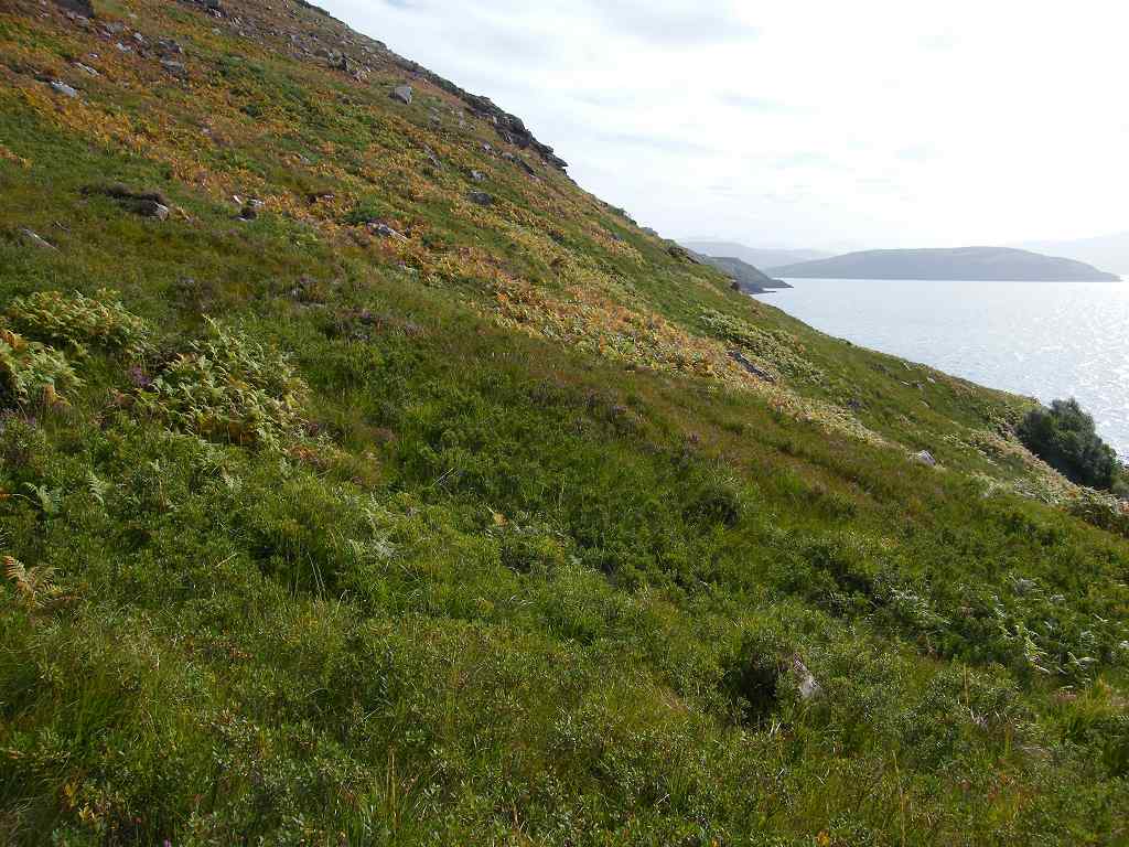 We were high up, and decided this path was definitely not for vertigo sufferers! But that didn’t bother either of us much, we just went more slowly and took more care.
  What bothered us more was that the sun came out and it got very hot. There was no wind, and neither of us like the heat.
 We came to a little copse of birch trees which were practically obliterating the path — underneath them was a tiny bit of blissful shade! We decided it was lunchtime, and sat down to eat our sandwiches.
 Reluctantly we moved on, we still had a lot of miles to cover and we were progressing extremely slowly because we were having to be so careful. There was a steep slope down to a stony beach, but it would be no good going down there because cliffs rose up very quickly at the end of it. It seemed as if we were walking along halfway up a cliff — we hadn’t expected the path to be so tricky.
 All the literature we had read about it talked about a “glorious path” and things like that, but hadn’t emphasised it’s difficulty. Afterwards we both agreed that this trail was more demanding than the yomp across the pathless moors from Cape Wrath to Sandwood Bay! Thank goodness the weather was balmy today.
 We came to a deep gully which was impossible to cross at that point. We had been expecting that, for it was marked on the map with the footpath going several hundred yards inland to a ford. We had to do a bit of minor rock-scrambling to get up there, pass several little waterfalls, and at last we came to some stepping stones which allowed us to cross the burn safely.
 The path led down the other side next to a fence. When we got over the lip of a hill we discovered that there had been a landslip, and several yards of the path were no more! So we hung on to the fence monkey-style (not barbed wire, thank goodness!) and picked our way across. Then we decided to climb over the fence as it was easier despite there being no path that side. Further down we climbed back, where a vestige of a real path appeared. We saw a couple behind us, up near the stepping stones. They seemed to appear from nowhere, we don’t know how they approached that spot without us seeing them. We thought they were following us and would soon catch up, but then they turned back and disappeared again. They were the only people we saw for the whole length of the Postie’s Path.
 On we went, mile after difficult mile. Slowly but surely. The path twisted and turned, went up and down with minor rock-scrambling — it seemed to go on forever. But it was well way-marked, and for that we were deeply thankful to whoever built those cairns and put those posts in. We would have gone wrong a hundred times without them! When we looked back, we had great difficulty in making out the path on which we had come. We seemed to be climbing all the time, we were very high.
 AT LAST we topped a hill and were rewarded with a glorious view down to Ardmair Point — and we could see our caravan! (through the binoculars, that is!) Our spirits surged — for we knew we were beyond the point of no return and it would be quicker to go on than to go back.
 But our troubles were not over yet, we were still climbing.
  We couldn’t understand it — we could see the River Canaird far below, which we knew we would have to cross before we got to the road.
 But the path continued up and up — and up and up, we thought it would never end.
  When sitting in our caravan at Ardmair Point the day before, we had tried to work out where the path came down on the mountain opposite.
  We had got it completely wrong, we never thought the path would actually be down from the top!
 But it was. It was five-thirty before we got to the final descent, and it was steep! There were the way-markers zigzagging down an almost vertical cliff! I haven’t been very good on descents since my skiing accident ten years ago (pins, plates and screws still doing fine in my legs, thank you, and no trouble — I wouldn’t even know they were there) as I lost my confidence then. Colin had to help me down nearly every step. My knees kept giving out, it was very hard on them. Colin’s knees were suffering too, but he didn’t make a fuss. I think he was too worried that I would break an ankle, or something stupid like that. But my past accidents have only occurred when I wasn’t paying full attention to what I was doing, so I concentrated on every step and was OK. It took us a whole hour to get down to river level, much later than we had envisaged.
 We were beginning to lose the light by then, and I didn’t take any more photographs. I had put my camera away in my rucksack for the descent, then we were anxious to get back to the caravan before it got dark. At least we hadn’t got caught on the mountain in the dark, that would have been a nightmare! As we came out on to the path at the bottom of the descent there was a warning notice about “remote, sparsely populated, potentially dangerous mountain country” for hikers going the other way. So we knew we were out of that kind of terrain. But we didn’t want to go to Strathcanaird because it was more than two miles in the wrong direction. We wanted to take a short cut across Blàr Mòr, which was in front of us, to reach the river bank so we could walk along it to a bridge. The problem was — there was a deer-proof fence in the way! Colin had a look along the fence in the opposite direction to Strathcanaird, and found a kissing gate into the enclosure. Phew! I didn’t fancy climbing that high fence!
The track we had intended taking round the edge of Blàr Mòr was completely waterlogged, we couldn’t have walked along it without sinking into mud well above our ankles. So we decided to walk straight across the moor, which was little more than a field, to pick up the track the other side. Using the compass, we went east rather than south in order to avoid coming to another swamp. The going was OK despite the lack of path, but when we got to the other side the path marked on the map just didn’t exist — typical Scotland! We were on top of a steep bank, and we wanted to be down there, not up here. So we zigzagged down through the ferns (scratchy! ow!) which were already changing colour as if it was autumn — not for another four or five days! We emerged on to a wide, flat, dry track (bliss!) which was very easy walking, and very soon joined the riverside track where we wanted to be.
We had to walk upstream for about three hundred yards before we came to a wooden bridge where we were able to cross the river. Then we walked downstream for nearly two miles as the daylight continued to fade. We passed a big white house that looked furnished but unoccupied. The track, almost a road by now, swept away to the left to join the main Ullapool road about half a mile hence. But there was a footpath marked on the map which went straight up a bank to the road, and that was a whole mile shorter.
We looked and looked in the increasing gloom, but we couldn’t find this wretched path. It seemed to go out from the garden behind a cottage, but we couldn’t see it. There was a light on in the cottage, and eventually a man came out to see what we were doing. He admitted he had “hidden” the entrance to the path behind some rubbish, but said he would show us where it was. We had a long conversation. He told us he was just back from Mongolia, having driven an old car there with his son in a rally. They did this for a charity, and he gave us the name of the website. I did remember this although I didn’t write it down, and a week or so later I did look it up on the internet — and was impressed with their achievement. But I’ve since lost the link, sorry.
He offered us a cup of tea, and said he would drive us back to the caravan site afterwards as it would be pitch dark very soon. That was very tempting especially as he was the first person we had met since Achiltibuie, but we had to explain to him that we had to walk it tonight, otherwise we would have to come back tomorrow and start our next Walk from there. We can’t have any gaps! He obviously wanted to talk, but it was getting darker by the minute and the midges were beginning to bite! At last he showed us where the footpath was — it was very overgrown, quite steep but thankfully also quite short. He promised he would clear it and that it would be “better when you come next year”! We didn’t point out to him that by this time next year we hope to be at least two hundred miles further south!
We scrambled up to the road and walked the last mile in semi-darkness, leaping into the grass every time a pair of headlights appeared. We entered the caravan site at the north end, past the chalets and the jetty. We thought the youths on the jetty were fishing, but when we got close we realised they were not, just drinking lager. No wonder they were making such a noise!
That ended Walk no.229, we shall pick up Walk no.230 at our caravan parked on the site at Ardmair Point. It was eight o’clock, so the Walk had taken eleven hours. We were both utterly exhausted, so I scrambled together a meal as quickly as I could, then we went to bed. We left the hire car in Achiltibuie, and collected it the next day.

No comments:
Post a Comment