Weather: Stormy hail showers, but very sunny in
between. There was a strong wind all day
which was bitterly cold.
Location: Lonbain to Applecross.
Distance: 9½ miles.
Total
distance: 2242 miles.
Terrain: All undulating quiet road, except the last
mile which was track, moorland path and a rough track through woods.
Tide: Going out.
Rivers: No. 246, River Applecross.
Ferries: None.
Piers: None.
Kissing
gates: Nos.209, 210 & 211 all in the
last mile.
Pubs: Applecross Inn where Colin drank Isle of Skye ‘Red Cuillin’ and I drank Symonds ‘Founders
Reserve’ cider.
‘Historic Scotland’ properties: None.
Ferris wheels: None.
Diversions: None.
How we got there and
back: We were staying in our caravan in
Applecross, and we had hired a small car locally so we had two. This morning we drove the hire car to
Lonbain.
At the end, we
finished at the caravan in Applecross.
After a rest and refreshment we drove our own car to Lonbain, then both
cars back.
The next day we
drove to the Kyle of Lochalsh, me in the hire car and Colin towing the caravan
with our own car. I returned the hire
car, then we took the rest of that day and all of the next to tow the caravan
home to Malvern.
We were still sitting in the car above Lonbain when we noticed how
beautiful the mountains on Skye looked with snow on their tops. SNOW?! Then we watched as both Raasay and Skye
disappeared in a maelstrom of cloud.
That should have warned us, but naively we got out of the car to begin
the Walk.
The wind was bitter, so we
gritted our teeth and started in marching mode.
It wasn’t more than a few minutes before the wind increased tenfold, and
we were battered by hailstones! Fortunately it
was blowing from behind us — I don’t think we could have walked against it —
but even so the hail really stung the backs of our legs. I thought to myself, “Why are
we doing this? We don’t have to!” I was questioning my sanity once again. Colin said he quite enjoyed it, in a way. Then I was questioning his sanity!
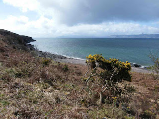
However it didn’t last long, such storms rarely do. Soon we were bathed in glorious sunshine with
breathtaking views, though the wind was still bitter and remained so for the
whole of the Walk. We walked fast!
We saw a deer on the horizon. Then
we realised there was a whole herd of them camouflaged by the terrain. When they ran up to the horizon they made a
good picture against the sky. It was
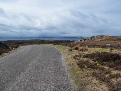
very remote where we were — no habitation, just rocks, the sea, streams
tumbling down almost vertical rockfaces and the narrow road we were walking
along with an average of about three vehicles an hour. But the views were amazing, the Cuillins on
Skye seemed to get ever nearer.
We came to a sandy beach which we had planned to walk on, but we couldn’t
because the tide was not far enough out.
It is such a long time since we’ve walked along a sandy beach, and
although this was only a short one we were disappointed that it wouldn’t be
worth the effort of getting down there.
We sat behind a rock, desperately trying to shelter from the icy wind,
and ate our pies.
As we walked on we endured another hailstorm, but this one was
short-lived thank goodness. I kept
having to put the camera away out of the weather, then get it out again because
the views were so fantastic. Raasay,
Skye and the Cuillins kept disappearing behind storm clouds, but soon
reappeared each time. The light was
constantly changing, I was unable to capture all its different moods with my
camera.
The old bridle path wound round the hill at a much higher elevation than
the road. We were quite glad the road
was nearer the sea, we didn’t fancy climbing mountains today. But that was the only way until just over thirty years ago, until then all the
hamlets we had passed since Shieldaig were really cut off from the rest of the
world.
Our road seemed to narrow, and we were squashed on to a narrow strip
between the mountains and the sea. We
rounded a corner, and were rewarded with a wonderful vista across to Applecross
itself. We could even see our caravan
perched on a ‘platform’ behind a ribbon of houses — if we looked through the
viewfinder at full zoom!
We sat by a
huge rock and ate our sarnies. We were
bemused to see snow up on the Pass. We
had both driven over there in recent days, and we wondered if it was now
closed.
We walked on across Applecross Bay. There was no point in going down on to the beach, which was quite stony anyway, because it is bisected by a river. So we stayed on the road. We came to a plaque which told us the road we had been walking on was only opened in 1976! We hadn’t realised it was that recent. Before that the communities this side of the mountains could only be reached over the Pass which is often blocked with snow, or along the bridle path, or by boat.
We passed a highland cow in a field, but he (or she) flatly refused to pose for my camera — food was far more important!
We crossed the river on the road bridge.
Colin saw some steps leading down to the beach. At the bottom he found a large rusty spoon
attached to a chain. Was it some kind of
well, or what?
We passed the end of the road leading up to the Pass, the highest paved public road in Britain. Two red notices warned us that there is a high snow risk and the road is often impassable because of this.
Also that it is unsuitable for caravans which should be taken round via Kenmore and Shieldaig, the way we had walked over three days. We strode on towards the pub, but didn’t quite make it before we were caught in another hailstorm.
I nearly fell asleep in the warmth of the pub. Perhaps we were ‘demob happy’ because we knew
the walking was nearly done for the time being, and tomorrow we were going
home. Also, I had a weekend with my
lovely little grand-daughter, Natalie, to look forward to. I don’t see my grandchildren very often, so
when I do spend time with them it is a real treat! We could have ended the Walk there and then,
for the pub is situated just below the caravan site. To continue towards Toscaig is a dead end,
but we had decided to walk two more miles round a small lochan and approach the
site along a track from the south. In
the nice warm pub we regretted making such a decision!
But we pulled ourselves together and marched on. The village petrol station amused us, one
pump had its front laying on the ground and a bag over its top. The unleaded pump was blank, obviously not
working. The Diesel pump was working, but
had a notice which said, “Cash sales only, please pay at the shop”. Now the shop is in someone’s house a couple
of miles down the road in Camustiel.
Such trust! We didn’t use this
petrol station, we didn’t dare to think what the cost of the fuel might be in
this remote place — if, indeed, they had any!
We could have climbed straight up a footpath to the caravan site above, but we decided to do a two-mile circular walk instead. We walked a little along the road until we came to the village which has very few houses, some of which are derelict. We passed a lochan, then left the road to continue on a track round the water. On the far side we climbed a moorland path and entered a wood. It had started to hail again, so I gave up with pictures and put the camera away. A track took us down through a dark wood to a farm and the caravan site.
We could have climbed straight up a footpath to the caravan site above, but we decided to do a two-mile circular walk instead. We walked a little along the road until we came to the village which has very few houses, some of which are derelict. We passed a lochan, then left the road to continue on a track round the water. On the far side we climbed a moorland path and entered a wood. It had started to hail again, so I gave up with pictures and put the camera away. A track took us down through a dark wood to a farm and the caravan site.
That ended Walk no.243, we shall pick up Walk no.244 next time at the
entrance to the caravan site in Applecross.
It was ten past four, so the Walk had taken six and a quarter hours. After a rest, tea and biscuits in our caravan,
we drove our own car to Lonbain, then drove both cars back to the site.
The next day we drove to the Kyle of Lochalsh the long way, not over the
pass. I drove the hire car and Colin
towed the caravan with our own car. I
returned the hire car to its owners, then we took the rest of that day and all
of the next to tow the caravan home to Malvern.


