Ages: Colin was 67 years and 339 days. Rosemary was 65 years and 116 days.
Weather: Sunny and warm at first. ‘Fair-weather’ cloud and a cold wind got up later.
Location: Red Point to Lower Diabaig.
Distance: 8 miles.
Total distance: 2197 miles.
Terrain: Rough path over moorland. It was uneven, undulating, swampy and quite steep in places. A difficult Walk. I forgot my trekking sticks, which made it even more problematic for me.
Tide: Out, coming in.
Rivers: No.236, Craig River.
Ferries: None.
Piers: None.
Kissing gates: Nos.203, 204, 205 & 206 all at Red Point Farm.
Pubs: None.
‘Historic Scotland’ properties: None.
Ferris wheels: None.
Diversions: None.
How we got there and back: We were staying in our caravan in Gairloch, and we had hired a small car locally so we had two. This morning we drove both cars all the way to Lower Diabaig (40 miles). We left our own car there, and drove back to Red Point in the hire car (47 miles).
At the end, we finished at our car parked in Lower Diabaig. After tea and caramel shortcake, we drove to Red Point to pick up the hire car. Then we drove both cars back to our caravan in Gairloch (13 miles).

Once more we are walking on my grandmother’s birthday, must be a good day for walking. She would have been 132 years old today — happy birthday Grandma! You were a treasure!
Weather: Sunny and warm at first. ‘Fair-weather’ cloud and a cold wind got up later.
Location: Red Point to Lower Diabaig.
Distance: 8 miles.
Total distance: 2197 miles.
Terrain: Rough path over moorland. It was uneven, undulating, swampy and quite steep in places. A difficult Walk. I forgot my trekking sticks, which made it even more problematic for me.
Tide: Out, coming in.
Rivers: No.236, Craig River.
Ferries: None.
Piers: None.
Kissing gates: Nos.203, 204, 205 & 206 all at Red Point Farm.
Pubs: None.
‘Historic Scotland’ properties: None.
Ferris wheels: None.
Diversions: None.
How we got there and back: We were staying in our caravan in Gairloch, and we had hired a small car locally so we had two. This morning we drove both cars all the way to Lower Diabaig (40 miles). We left our own car there, and drove back to Red Point in the hire car (47 miles).
At the end, we finished at our car parked in Lower Diabaig. After tea and caramel shortcake, we drove to Red Point to pick up the hire car. Then we drove both cars back to our caravan in Gairloch (13 miles).
So we had to drive two cars a total of 100 miles each to set up an 8 mile Walk!!

Once more we are walking on my grandmother’s birthday, must be a good day for walking. She would have been 132 years old today — happy birthday Grandma! You were a treasure!
 We took so long to set up this Walk, it was lunchtime before we got started. So we were only a few yards from the car when we sat down and ate our pies. An old farm dog tried to nose in on our picnic but he wasn’t too much of a nuisance, he just wanted to be friendly. We were passed by farm children, rushing down to the beach with towels. It looked lovely down there in the bright sunshine, but I bet the water was perishing!
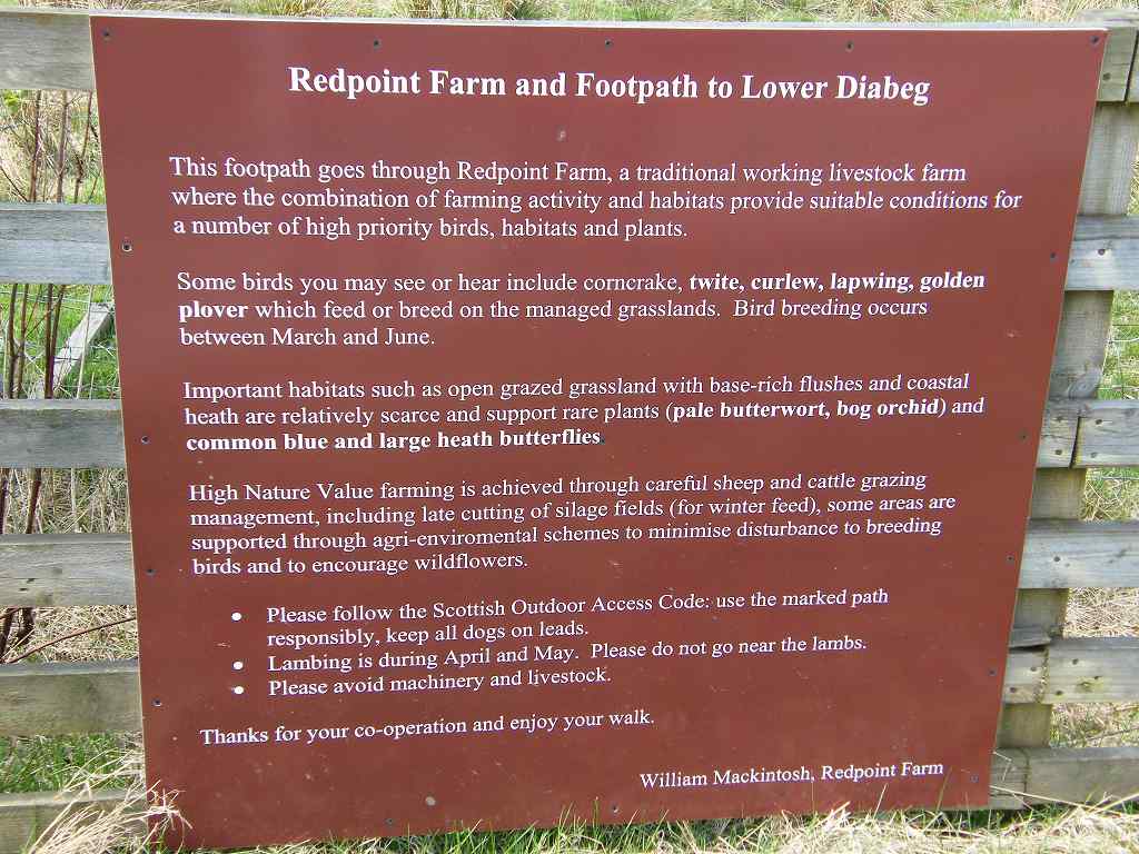 By the gate of Red Point Farm was a long notice telling us all about the farm, and the wildlife that lives hereabout. It is a popular public footpath along the coast to Lower Diabaig, and the farmer just wants hikers to understand a working farm, respect the wildlife and act responsibly. He ended with the words, “Thank you for your co-operation and enjoy your walk.”
 In the farmyard we were met by a little dog which stood it’s ground yapping wildly, but it’s tail was rapidly wagging. Not very fearsome!
  As we left through a kissing gate we passed a “Beware of the Bull” notice, but we didn’t see any bulls. Didn’t see any cows either, come to think of it. What we did see, on the ground, was a skylark skittering around. Colin didn’t have his camera, so I took the picture.
 We walked across grassy dunes towards an abandoned fishing station, then took a path which went over a stile and on up a mountainside. It was a bit rough, to say the least. We had expected it to be a lot easier. We met a lone man coming towards us, but it turned out he was not a serious walker. He told us he had wandered up from the beach where his wife was sitting, but when the path got tricky he turned round and came back.
 The state of the path worsened, and it reminded us of the “Postie’s Path” from Achiltibuie, which wasn’t all that far back. I had struggled with that, and I was beginning to struggle with this. There were lots of streams to cross, it was very uneven and boggy in places.
 Despite the sun, a wind got up and it was quite cold. I thought of the local children we had seen running towards the beach — I expect they’re quite hardy living up here! We tried to sit out of the draught behind a gorse bush to eat our sandwiches, but we were still cold.
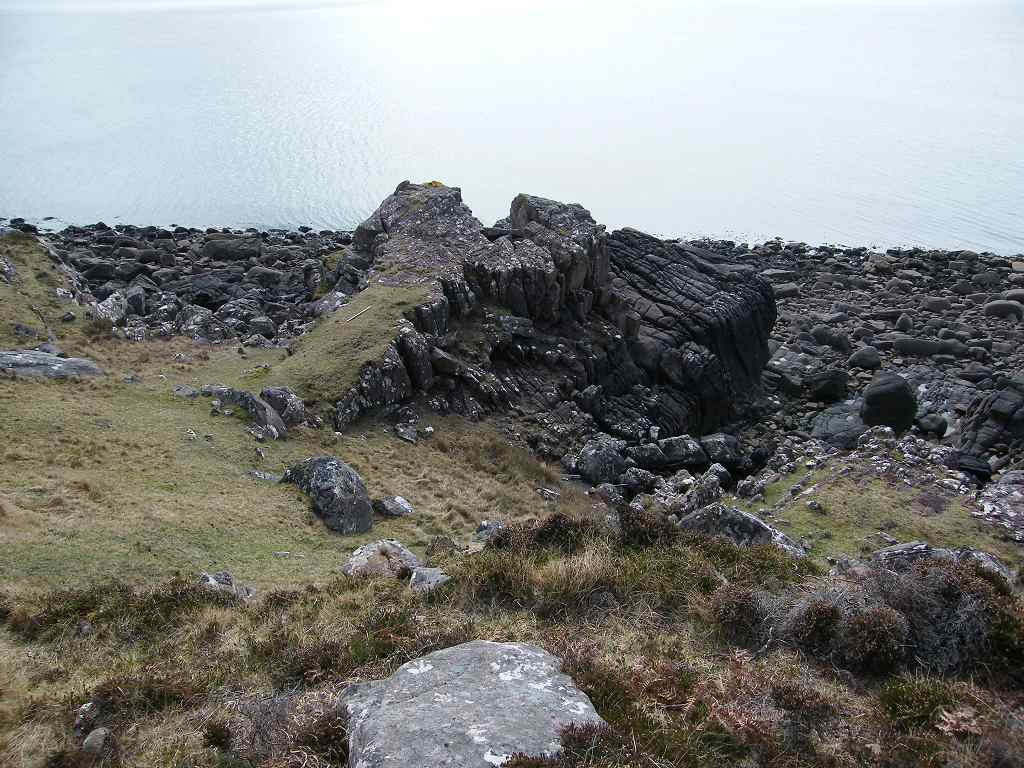 We soon carried on, it was too cold to dally. I had read lots of literature about this eight-mile walk before we came. It is described as “spectacular” and “well worth doing” — both true. But no one had described how difficult it is! We found it to be a narrow, uneven, swampy, steeply undulating apology for a path along the side of a mountain — very difficult walking.
  I got tired very quickly, and was extremely slow because of it. With my lack of binocular vision, I do find walking over uneven ground exceptionally tricky. At short distances I cannot see depth, therefore I’m much more likely to trip on a protruding stone than the 83% of the population who can see depth.
 I had left my trekking sticks in the ‘wrong’ car, we were walking towards them! It was bad enough trying to sort out which of the two cars to put all the boots and shoes this morning, the sticks got left in our own car and I didn’t remember them until it was too late.
 About halfway along we met a couple, much younger than us, walking the other way. They said the remote hostel by the Craig River was locked and didn’t look as if it was used any more — wasn’t it sad? And we had been hoping to rest up there for a short while when we reached it! They told us some friends were meeting them at Red Point, so they hadn’t had to drive two cars the long distances we had to. Lucky them! Our friends all live much too far South.
 As we approached the Craig River, the path got worse. We didn’t believe that was possible, but it did. We had to scramble uphill through rocks, swamp and heather. We lost the ‘path’ several times, and had to push our way through prickly bushes until we found what we thought might be it again. It was very difficult and not enjoyable at all.
 I did wonder if I had bitten off more than I could chew, and deeply regretted not having my sticks with me. At one point I fell and sprained the little finger on my right hand. It was too painful for Colin to pull me up over big rocks using that hand, so I had to remember to stand the other side of him every time he tried to help me out.
  But we did find, at last, the wooden footbridge across the Craig River, so we knew then we hadn’t gone wrong too much. How people coming the other way cope I don’t know. They have no landmark to aim for, and there is no sign of the path leading away from the north side of the bridge.
 We walked up to the hostel, but foolishly we didn’t try the door. Because we had been told it was locked, we just assumed it was and ate our chocolate sitting on a tussock not far away in a bitterly cold wind. In hindsight, perhaps the door was just stiff. (Hindsight is a wonderful thing!)
 There was a plaque nearby telling us the path from thereon had been rebuilt by “the Footpath Trust”. Thank you to those wonderful people, whoever you are. To say I was relieved was an understatement!
 The path was much better even though there were a few dodgy sections through swamps and over rocks, but we never lost the way again. We climbed a big hill — that was tough — and seemed to be on top of the world.
 We were a little further away from the coast, but we had magnificent views all the way! Despite our weariness, we both got that “wonderful to be alive” feeling.
 We met a group of foreign youths coming the other way. Their English was not too good except for the one who appeared to be their leader. He told us they were making for the hostel to spend the night, and how far was it?
 We told them it was locked, and they looked so downhearted it was pitiful — they obviously had nowhere else to stay. They went on anyway, I hope they managed to get in. How we wished we had tried the door for ourselves!
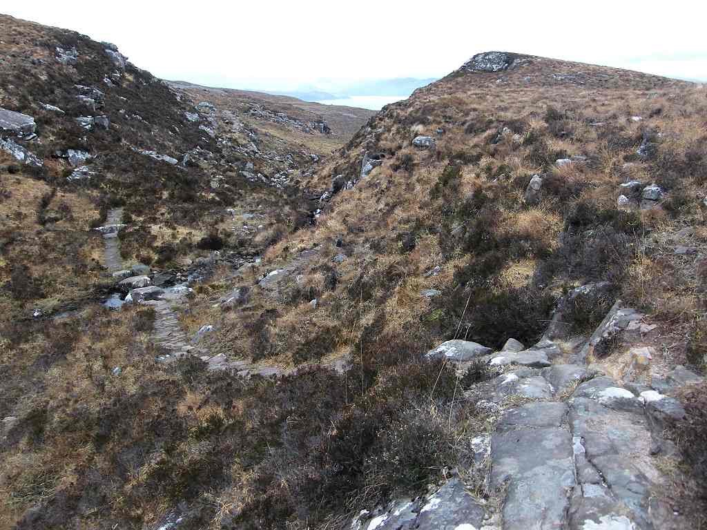 On and on we went, crossing ridges and still more ridges.
  There was a cairn on top of one, where the path had expanded into a huge slab of rock so it was difficult to see exactly where it exited.
 It seemed to be an awful long way to Lower Diabaig, but then we were tired — at least I was. The sun came out as the bay came into view, and it was simply glorious!
  We could see across Loch Torridon towards Fearnmore and Shieldaig, and it all looked beautiful.
 At last we left the moors over a stile and on to a road. There was a sign pointing back the way we had come telling us it was a footpath to Gairloch, by Craig. From there Colin went on more quickly to make the tea so I could have a cup as soon as I reached the car.
  As I descended towards the harbour, I was thinking that Lower Diabaig must be one of the most scenic villages in the world! That is, when it’s not the midge season — and it wasn’t in April! (I’m not sure I would like it so much in July.)

There was a derelict fishing boat off the beach, but even that looked somehow beautiful silhouetted in the setting sun. A magical place!

That ended Walk no.237, we shall pick up Walk no.238 next time by the harbour in Lower Diabaig. It was twenty five past seven, so the Walk had taken six hours and forty minutes. We could hardly believe that it had taken that long to walk a mere eight miles! After refreshing ourselves with tea and caramel shortcake, Colin drove us all the way back to Red Point — forty-seven miles by road. By then it was dark. He quickly got into the hire car, and I followed him driving our own car the thirteen miles back to our caravan in Gairloch. I found it quite scary driving along that narrow twisting road in pitch darkness, particularly when the occasional vehicle came the other way, and across the awkward river bridge near Badachro. I had to keep singing loudly to stop myself falling asleep. How relieved I was when we turned into the caravan site in Gairloch!
That would have been an amazing Walk if it hadn’t taken so long to set up, and if the path between Red Point and Craig hadn’t been in such a poor state of repair. We were very lucky with the weather, so we were grateful for that.
The next day Colin towed the caravan and I drove the hire car to Applecross, the other side of Loch Torridon and then some.

2 comments:
Yes this is a tough walk! I had to do it both ways in the same day, there and back. The old Youth Hostel at Craig is now a Bothy and open again, I stopped to have a quick look inside.
I agree with you that the worst part of the path is just before the river, until you reach the bridge. I was beginning to wonder if the bridge would ever come into sight! Glad to see you are on the move again, I hope it all goes well for you.
Absolutely brilliant read. Thankyou for such detailed information and wonderful pictures. Felt I was walking the route with you.My friend and I hope to do this walk when covid restrictions allow. Thankyou.
Post a Comment