Ages: Colin was 67 years and 341 days. Rosemary was 65 years and 118 days.
Weather: Very sunny, but there was a cold wind.
Location: Lower Diabaig
to Alligin Shuas.
Distance: 4½ miles.
Total
distance: 2201½ miles.
Terrain: Rock scrambling at first! Then up a steep gully. The path was narrow on the edge of steep
hills, very undulating, swampy with fords, boggy, very uneven and often the
route was unclear. It was an extremely
difficult Walk, even though I did have my trekking sticks to help me today.
Tide: Out.
Rivers: None, only streams.
Ferries: None.
Piers: None.
Kissing
gates: No.207 all by itself in the
middle of nowhere!
Pubs: None.
‘Historic Scotland’ properties: None.
Ferris wheels: None.
Diversions: None.
How we got there and
back: We had our caravan in Scotland,
and we had hired a small car locally so we had two. Yesterday we moved the whole caboodle from
Gairloch to Applecross along tortuous roads!
This morning we drove both cars over the highest road in Britain
to Torridon where we intended to finish today’s Walk. We left our own car there, and continued in
the hire car to Lower Diabaig.
At the end, we
didn’t finish! The Walk had been so
difficult, and we had taken so long that when we hit a road in Alligin Skuas I
sank to the ground and declared I could go no further! Colin left all his baggage with me, and
strode back along the road towards Lower Diabaig
(nearer than Torridon) trying to thumb a lift.
He only got a lift for the last half mile, so he was gone an hour and twenty
minutes, by which time I was getting quite cold. At last he arrived in the hire car, and we
drove back to Torridon where the car containing the hot tea and caramel
shortcake was parked. We decided to
leave the hire car parked in Torridon overnight, so only took our own car back
over the highest road in Britain
to our caravan.

Today’s Walk was our toughest challenge so far, even though it was
short. We hadn’t expected it to be so
difficult, we were rock-climbing at the beginning! Fortunately we were blessed with good
weather, I don’t think we could have attempted it in the rain.

We took a while to set up the Walk because the nearest caravan site was
at Applecross, a good many miles away over the mountains and we’d had to drive
two cars from there. So we sat by the
harbour at Lower Diabaig and ate our pies
before we started.

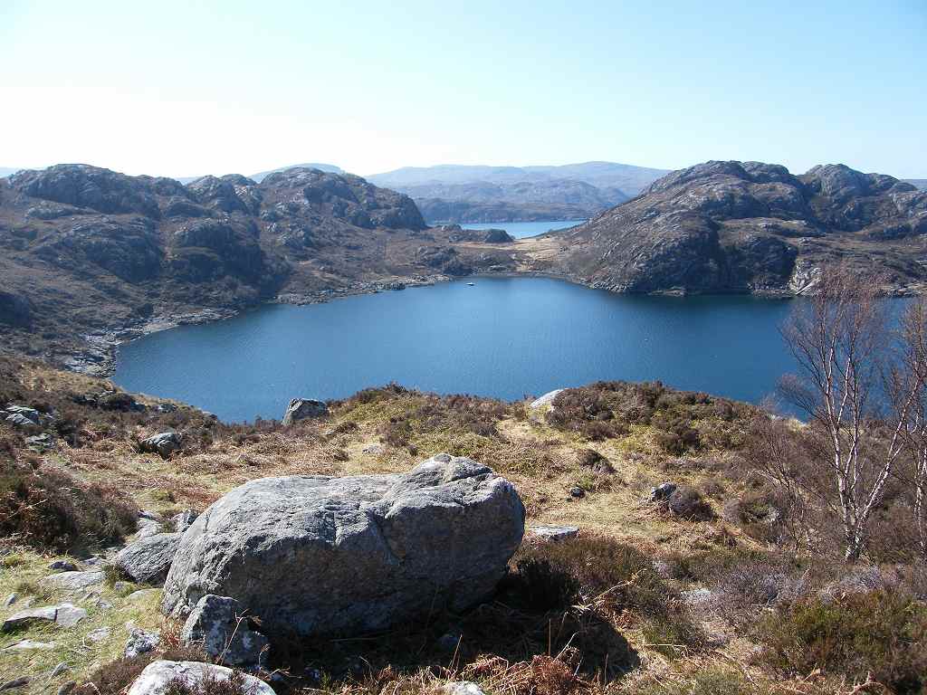
We were looking at
the interesting rocks around us, and out to sea where we could see the Isle of Skye. Lower Diabaig is such a breathtakingly beautiful village,
we felt we wanted to give everything up and come and live here! But it is so isolated, I doubt
whether that would be very practical.
The road is pretty tortuous, not for large vehicles and probably closed
a good bit of the Winter. And we’ve
never been here during the midge season!

Despite the sunshine, we put on our kags for warmth before we left the
harbour. Then we followed a dustbin
lorry to the end of the road, amazed at how it was coping with wheelie bins
despite the steep slope. Come to think
of it, the only way it could have got here was along that narrow, steep and
twisting road from Torridon — so the driver must have been used to steep
slopes.


The footpath led off through the gate of the last house, and immediately
we were climbing a steep slope. When
this got to be almost vertical, we came across a ‘helpful rope’ which had
apparently been left attached to a rock to aid walkers like ourselves! We had to trust it was properly tied, and did
find it useful in hauling ourselves up.
(This reminded us of Iceland,
where such ropes are left wherever there is a path through difficult terrain.)


Further on there was the ruins of another cottage.


That ended Walk no.238, we shall pick up Walk no.239 next time on the
road to a cottage in Alligin Shuas. It
was quarter past six, so the Walk had taken six and a half hours — and we’d
only progressed four and a half miles!
We decided that the hire car at Lower Diabaig was fractionally nearer
(by road) than our own car parked in Torridon, so Colin left all his baggage
with me and set off to walk back. He was
hoping to thumb a lift, but the road is so remote he wasn’t even passed by a
vehicle until he was within half a mile of Lower Diabaig. So he only got a lift for this last bit, and
I had to wait an hour and twenty minutes for him to reappear. By then the sun had gone down and I was
getting uncomfortable and cold. At last
he arrived, and we drove to Torridon where our own car containing the hot tea and
caramel shortcake was parked! We decided
to leave the hire car parked in Torridon overnight as we intended finishing the
Walk to Torridon the next day. We took
our own car back over the highest road in Britain to our caravan in
Applecross.
I found it very frustrating to be overcome by extreme exhaustion as I was
today. I had been finding I was getting
overtired a lot more often lately, and today I was near to collapse. At the time I put it down to the fact that
the Walk had been extremely challenging and that I was getting older. But why didn’t Colin feel so tired when he is
two and a half years older than me?
About a year later I had to visit the doctor on a totally unrelated
matter, and he sent me for a blood test.
I was diagnosed with an underactive thyroid — quite a surprise as I had
no idea. I started taking thyroxine
tablets, and once they had got my levels right I felt I had a new lease of
life! I now have so much stamina I am
leaving Colin behind, and I find I can almost double the length of the
Walks. No more collapsing with
exhaustion for me!

No comments:
Post a Comment