Weather: Sunny intervals with the occasional very
short shower, one of which was hail!
Location: Cardoness Castle to Kirkcudbright.
Distance: 17 miles.
Total distance: 2948 miles.
Terrain: Main road for only a hundred yards, then down a bank. Lots of tracks, lots of very quiet roads, lots of sun-speckled bluebell woods and some tiny bits of beach.
Tide: Going out, coming in.
Rivers: No.354, Water of Fleet. No.355, River Dee.
Ferries: None.
Piers: None.
Kissing gates: No.304 at Bar Hill. Nos. 305 & 306 at Brighouse Bay
Pubs: ‘The Selkirk Arms’ in Kirkcudbright where Colin stayed when he was working on Kirkcudbright Ranges in the 1970s. We quaffed two Sulwath beers, ‘The Grace’ and ‘Galloway Gold’. Both very nice! (We did this on one of our ‘rest’ days, but we didn’t have lunch there, as planned, because it was too expensive. We went to a local café instead, where we had a superb meal at a much more reasonable price.)
‘Historic Scotland’ properties: No.39, MacLellan’s Castle (which we visited on a different day).
Ferris wheels: None.
Diversions: None.
How we got there and back: Yesterday we had driven up from home and booked our caravan into a site in Dalbeattie. This morning we drove into Kirkcudbright, parked the car and tried to catch a bus to Cardoness Castle. Colin asked the driver of a bus parked up there if he was the correct bus — he said “No!” but he would take us if we wanted because he was going that way. He refused to take any money for fares because “I haven’t got a machine!” We were the only passengers, and he dropped us at the exact spot we wanted. Thank you!
At the end we were at the car. We drove straight back to Dalbeattie for tea, biscuits and a lie-down.
Today started well with a free bus ride! (We think it was a school bus returning to base.) We walked eastwards along the main road from Cardoness Castle and crossed the river using the main road bridge.
 A few
yards further on we found that people before us had made an unofficial path
down the bank to a track where we wanted to be, so we scrambled down it. We had left the A75 forever! We were so relieved! We went through a gate on to the track which
came from under the main road, and we marched southwards.
A few
yards further on we found that people before us had made an unofficial path
down the bank to a track where we wanted to be, so we scrambled down it. We had left the A75 forever! We were so relieved! We went through a gate on to the track which
came from under the main road, and we marched southwards.
 It was so
quiet! The sound of the traffic faded
the further we walked, the sun was shining, we had views back to the castle and
everywhere was so green. It was
heavenly! There was a bit of a cold wind
blowing across from the river, but soon we entered woods where it was much
warmer.
It was so
quiet! The sound of the traffic faded
the further we walked, the sun was shining, we had views back to the castle and
everywhere was so green. It was
heavenly! There was a bit of a cold wind
blowing across from the river, but soon we entered woods where it was much
warmer.
 The sun was filtering through the new leaves, there
were wild flowers everywhere, we had views between the trees of the estuary, we
loved the mossy walls, the bluebells — it was all just breathtakingly beautiful!
The sun was filtering through the new leaves, there
were wild flowers everywhere, we had views between the trees of the estuary, we
loved the mossy walls, the bluebells — it was all just breathtakingly beautiful!

 Woodlands are exceptionally wonderful in the
Spring, especially woodland bordering the coast.
Woodlands are exceptionally wonderful in the
Spring, especially woodland bordering the coast.


 We reached a caravan site. It seemed to be residential but it was mostly
deserted. Perhaps it was holiday
lets. There was a nice beach attached,
and that was completely devoid of people on this lovely day. We walked a bit of the beach, crunching
shells, and sat on a rock which was out of the wind to eat our pasty /
quiche.
We reached a caravan site. It seemed to be residential but it was mostly
deserted. Perhaps it was holiday
lets. There was a nice beach attached,
and that was completely devoid of people on this lovely day. We walked a bit of the beach, crunching
shells, and sat on a rock which was out of the wind to eat our pasty /
quiche.
 We would have liked more beach,
but we had to exit at the main caravan site entrance where there was a phone
box without a door.
We would have liked more beach,
but we had to exit at the main caravan site entrance where there was a phone
box without a door.
 We walked a short bit of a very quiet road past some
cows who seemed to be admiring the view.
Then we followed a twisty potholed track past holiday chalets where a
notice told us pedestrians have right of way.
(I liked that!)
We walked a short bit of a very quiet road past some
cows who seemed to be admiring the view.
Then we followed a twisty potholed track past holiday chalets where a
notice told us pedestrians have right of way.
(I liked that!)
 We passed a
couple of nice beaches, and there were a few people about now, mostly
exercising their dogs.
We passed a
couple of nice beaches, and there were a few people about now, mostly
exercising their dogs.
 A notice told us
we were at Carrick Foreshore which is agricultural land with a path to a coastal
viewpoint. Cattle are excluded during
July and August. (No camping or
overnight parking. Please take your
litter and used barbecues home. Dogs are
your responsibility. Together we can all enjoy this special
place.)
A notice told us
we were at Carrick Foreshore which is agricultural land with a path to a coastal
viewpoint. Cattle are excluded during
July and August. (No camping or
overnight parking. Please take your
litter and used barbecues home. Dogs are
your responsibility. Together we can all enjoy this special
place.)
We then found a new path (not marked on the map) which followed the coast instead of twisting back inland through a farm.

 We could tell it is normally blowy in these
parts when we came across a dead tree which had bent in the wind so much it was
practically horizontal! There is a
derelict concrete harbour at Knockbrex
Bay, and we surmised it
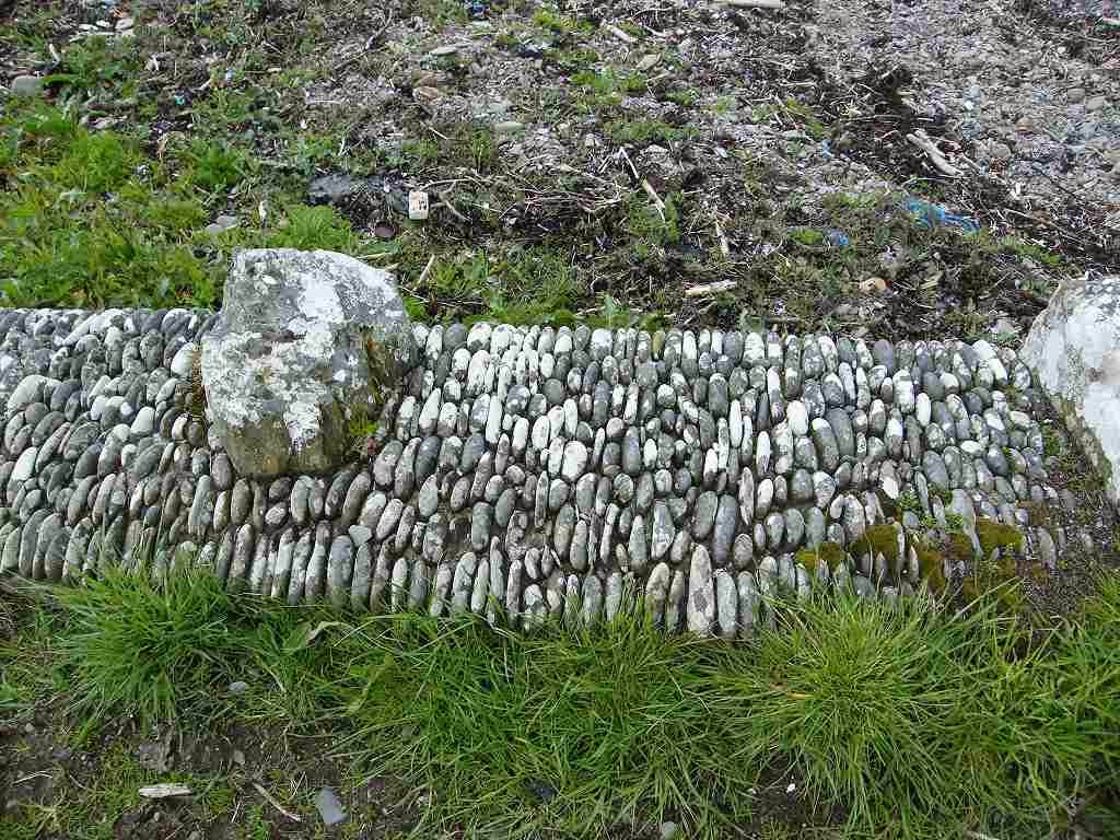
was something to do with the Second World War — it looked that old. There were very neat stones in the harbour
wall.
We could tell it is normally blowy in these
parts when we came across a dead tree which had bent in the wind so much it was
practically horizontal! There is a
derelict concrete harbour at Knockbrex
Bay, and we surmised it
was something to do with the Second World War — it looked that old. There were very neat stones in the harbour
wall.
 Colin found a gravestone, but we both failed to make
out the inscription on it — except that it was 19th century. The wind was still too cold to be
comfortable, so when we found a grass bank behind a gorse bush which shielded
us from the draughts, we sat down and ate our sarnies. After we got going again, we came across an
‘arbour’ with a seat in it which was perfectly sheltered and would have been
much nicer. Sod’s law!
Colin found a gravestone, but we both failed to make
out the inscription on it — except that it was 19th century. The wind was still too cold to be
comfortable, so when we found a grass bank behind a gorse bush which shielded
us from the draughts, we sat down and ate our sarnies. After we got going again, we came across an
‘arbour’ with a seat in it which was perfectly sheltered and would have been
much nicer. Sod’s law!
 The path connected up with a track round Bar Hill,
and saved us about half a mile of walking.
It started to rain, but not for long.
We saw lots of orchids on this patch, but we had already put our cameras
away to avoid them getting wet so we didn’t photograph them.
The path connected up with a track round Bar Hill,
and saved us about half a mile of walking.
It started to rain, but not for long.
We saw lots of orchids on this patch, but we had already put our cameras
away to avoid them getting wet so we didn’t photograph them.
 A derelict building reminded me vaguely of my
Grandad’s house in Arundel where we used to holiday every year until I was
eleven.
A derelict building reminded me vaguely of my
Grandad’s house in Arundel where we used to holiday every year until I was
eleven.
 I don’t know why, perhaps it was
the stone it was built from or the pseudo battlements round the top. What purpose did it have? Some kind of fancy pillbox? Colin pretended to be a sentry outside his
sentry box.
I don’t know why, perhaps it was
the stone it was built from or the pseudo battlements round the top. What purpose did it have? Some kind of fancy pillbox? Colin pretended to be a sentry outside his
sentry box.
We came out on to a quiet road and immediately it started to rain again — only this time it was hail! Only for a few minutes, thank goodness, because it hurt!
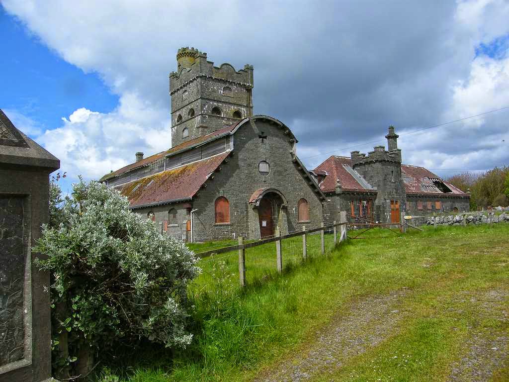
 We passed an
extraordinary building. At first we
thought it was another ‘castle’ of the tower-type because that is what it
looked like. But then it revealed itself
as an enormous Edwardian dairy, absolutely derelict but still a beautiful
building. It was HUGE! It was for sale, Grade A listed. Who is going to buy that with all its
restrictions and responsibilities? Very
neat stones in the outer wall — this seems to be a feature of this area.
We passed an
extraordinary building. At first we
thought it was another ‘castle’ of the tower-type because that is what it
looked like. But then it revealed itself
as an enormous Edwardian dairy, absolutely derelict but still a beautiful
building. It was HUGE! It was for sale, Grade A listed. Who is going to buy that with all its
restrictions and responsibilities? Very
neat stones in the outer wall — this seems to be a feature of this area.
 We stopped to chat to a man sitting on his garden
wall. He was very keen to tell us about
a ruined castle up ahead, but admitted, “There’s not much to see!” (He was right about that, so we didn’t bother
to divert to see it.) But he also told
us about some new coastal paths we shall come to which are not marked on the
map — useful information for which we were grateful.
We stopped to chat to a man sitting on his garden
wall. He was very keen to tell us about
a ruined castle up ahead, but admitted, “There’s not much to see!” (He was right about that, so we didn’t bother
to divert to see it.) But he also told
us about some new coastal paths we shall come to which are not marked on the
map — useful information for which we were grateful.
The road was dreary and always seemed to be going uphill — was this our imagination because we were tired? But it was very quiet, hardly any traffic so we shouldn’t complain really. Eventually we turned down an even quieter lane, then took a track across towards a farm. It turned out this is an official public footpath, but they didn’t tell us that until we were half way along. Good thing that the man on his garden wall had told us this was the way to go, otherwise we would have stuck to the road.
 We could hear cows mooing and as we approached the
gate where they had gathered, the noise got very loud. It was as if they were desperate to escape,
and some of them were trying to mount each other! There was a quad-bike working in the next
field, spreading fertiliser or something, and we think the noise of this had
upset them. They certainly were not
happy cows, or were they bullocks?
We could hear cows mooing and as we approached the
gate where they had gathered, the noise got very loud. It was as if they were desperate to escape,
and some of them were trying to mount each other! There was a quad-bike working in the next
field, spreading fertiliser or something, and we think the noise of this had
upset them. They certainly were not
happy cows, or were they bullocks?
We carried on to Brighouse Bay which is a very nice beach. We sat on a rock and ate our apples. We wished we could walk along the beach, but the road led away from it so this was only possible for a few yards.
 We decided to follow the man on the garden wall’s
advice, and go and look for the path through the wood he had told us about
which wasn’t marked on the map. So,
after about half a mile of tarmac, we turned up a concrete road which led
towards some cottages. Before we reached
them we turned right into a field and marched towards the woodland on the other
side — followed by a herd of cows! We
lost the path, and I was convinced we were on a fool’s errand. But Colin was determined — he stomped on and
found a sort of gate into the woods. It
didn’t look as if anyone had been that way for a long time.
We decided to follow the man on the garden wall’s
advice, and go and look for the path through the wood he had told us about
which wasn’t marked on the map. So,
after about half a mile of tarmac, we turned up a concrete road which led
towards some cottages. Before we reached
them we turned right into a field and marched towards the woodland on the other
side — followed by a herd of cows! We
lost the path, and I was convinced we were on a fool’s errand. But Colin was determined — he stomped on and
found a sort of gate into the woods. It
didn’t look as if anyone had been that way for a long time.

 A faint path led deep amongst the trees, so
we tried to follow it but lost it. Would
we have to retrace our steps and walk along the road? We were just about to do so when we
came across a well-trodden path leading across in front of us from right to
left!! This path was not marked
on our oh-so-new-and-expensive OS map, yet there it was, clear as a bell and
obviously well used.
A faint path led deep amongst the trees, so
we tried to follow it but lost it. Would
we have to retrace our steps and walk along the road? We were just about to do so when we
came across a well-trodden path leading across in front of us from right to
left!! This path was not marked
on our oh-so-new-and-expensive OS map, yet there it was, clear as a bell and
obviously well used.
 We were so relieved, I can’t tell you! What’s more, we were in a wildflower
heaven.
We were so relieved, I can’t tell you! What’s more, we were in a wildflower
heaven.
 We were surrounded by carpets
of wild garlic, bluebells, even orchids all in brilliant flower.
We were surrounded by carpets
of wild garlic, bluebells, even orchids all in brilliant flower.
 With the sun filtering through the new leaves
and views of the estuary through the trees, it was just perfect!
With the sun filtering through the new leaves
and views of the estuary through the trees, it was just perfect!
 We followed this path for over a mile, revelling in
all the beauty which surrounded us.
We followed this path for over a mile, revelling in
all the beauty which surrounded us.
 We
thought we were completely on our own, but towards the end we could hear
talking ahead. It was an elderly woman,
who was very chatty, out with her grand-daughter. They were collecting moss to make flower
baskets, so they told us. What a
delightfully old-fashioned thing to be doing!
We
thought we were completely on our own, but towards the end we could hear
talking ahead. It was an elderly woman,
who was very chatty, out with her grand-daughter. They were collecting moss to make flower
baskets, so they told us. What a
delightfully old-fashioned thing to be doing!

 It was shortly afterwards that we noticed the odd
rhododendron bush amongst the wild bushes.
We emerged from the wood into a posh housing estate, and exited to a
beach picnic site through a gate which said “Cottage Only” on the other side!
They were certainly keeping the existence of that lovely path a secret,
and we would never have found it if we hadn’t stopped way back to chat to a man
sitting on his garden wall. Thank you!
It was shortly afterwards that we noticed the odd
rhododendron bush amongst the wild bushes.
We emerged from the wood into a posh housing estate, and exited to a
beach picnic site through a gate which said “Cottage Only” on the other side!
They were certainly keeping the existence of that lovely path a secret,
and we would never have found it if we hadn’t stopped way back to chat to a man
sitting on his garden wall. Thank you!

 We were at Nun Mill Bay, time was getting on and we’d both
had enough of this Walk. We sat at a
picnic table to eat our chocolate, hoping it would give us enough energy to
tackle the last three miles which was all along a road. Colin amused himself by taking pictures of a
black-headed gull, and I had a look at a plaque on a stone plinth which read:
We were at Nun Mill Bay, time was getting on and we’d both
had enough of this Walk. We sat at a
picnic table to eat our chocolate, hoping it would give us enough energy to
tackle the last three miles which was all along a road. Colin amused himself by taking pictures of a
black-headed gull, and I had a look at a plaque on a stone plinth which read:
The ships timbers lying due east in the bay are all that remain of the schooner MONREITH, of Wigtown, wrecked in Kirkcudbright Bay on the 12th of November 1900.
Interesting, but we were just too tired to even look for the wreck even though the tide was out.


We took a deep breath, then route-marched the three miles along the road to Kirkcudbright. There was not much traffic so it wasn’t too bad.
 The road ran alongside the estuary, so we were treated to magnificent
views across the sands in the evening light.
We had to walk north ‘past’ Kirkcudbright, which we could see in the
sunshine across the way, before we reached the bridge over the river.
The road ran alongside the estuary, so we were treated to magnificent
views across the sands in the evening light.
We had to walk north ‘past’ Kirkcudbright, which we could see in the
sunshine across the way, before we reached the bridge over the river.

We passed the official town sign before the bridge. There were some youths on the bridge being loud and showing off, so we ignored them and barged past — I didn’t teach youths like that for sixteen years, plus a further six years part-time, without learning a thing or two about coping with this type of behaviour.

 As we walked towards our car, parked next to
MacLellan’s Castle, we passed a plaque about a town cat set into a wall. It gave a website, but when I tried to look it
up on my computer later it came up with 334 million websites about Las Vegas! So we never did find out what happened to
‘Ceasar’ except that he was the town cat from 1990 to 2004.
As we walked towards our car, parked next to
MacLellan’s Castle, we passed a plaque about a town cat set into a wall. It gave a website, but when I tried to look it
up on my computer later it came up with 334 million websites about Las Vegas! So we never did find out what happened to
‘Ceasar’ except that he was the town cat from 1990 to 2004.
We also passed a rather soulful wooden sculpture dedicated to ‘Loved Ones lost at Sea’. A mother hugging a child, I thought it was very meaningful.

That ended Walk no.293, we shall pick up Walk no.294 next time outside MacLellan’s Castle in the centre of Kirkcudbright. It was twenty-five to seven, so the Walk had taken us nine and a quarter hours. We drove straight back to our caravan in Dalbeattie for tea, biscuits and a lie-down.
Location: Cardoness Castle to Kirkcudbright.
Distance: 17 miles.
Total distance: 2948 miles.
Terrain: Main road for only a hundred yards, then down a bank. Lots of tracks, lots of very quiet roads, lots of sun-speckled bluebell woods and some tiny bits of beach.
Tide: Going out, coming in.
Rivers: No.354, Water of Fleet. No.355, River Dee.
Ferries: None.
Piers: None.
Kissing gates: No.304 at Bar Hill. Nos. 305 & 306 at Brighouse Bay
Pubs: ‘The Selkirk Arms’ in Kirkcudbright where Colin stayed when he was working on Kirkcudbright Ranges in the 1970s. We quaffed two Sulwath beers, ‘The Grace’ and ‘Galloway Gold’. Both very nice! (We did this on one of our ‘rest’ days, but we didn’t have lunch there, as planned, because it was too expensive. We went to a local café instead, where we had a superb meal at a much more reasonable price.)
‘Historic Scotland’ properties: No.39, MacLellan’s Castle (which we visited on a different day).
Ferris wheels: None.
Diversions: None.
How we got there and back: Yesterday we had driven up from home and booked our caravan into a site in Dalbeattie. This morning we drove into Kirkcudbright, parked the car and tried to catch a bus to Cardoness Castle. Colin asked the driver of a bus parked up there if he was the correct bus — he said “No!” but he would take us if we wanted because he was going that way. He refused to take any money for fares because “I haven’t got a machine!” We were the only passengers, and he dropped us at the exact spot we wanted. Thank you!
At the end we were at the car. We drove straight back to Dalbeattie for tea, biscuits and a lie-down.
Today started well with a free bus ride! (We think it was a school bus returning to base.) We walked eastwards along the main road from Cardoness Castle and crossed the river using the main road bridge.
We then found a new path (not marked on the map) which followed the coast instead of twisting back inland through a farm.
We came out on to a quiet road and immediately it started to rain again — only this time it was hail! Only for a few minutes, thank goodness, because it hurt!
The road was dreary and always seemed to be going uphill — was this our imagination because we were tired? But it was very quiet, hardly any traffic so we shouldn’t complain really. Eventually we turned down an even quieter lane, then took a track across towards a farm. It turned out this is an official public footpath, but they didn’t tell us that until we were half way along. Good thing that the man on his garden wall had told us this was the way to go, otherwise we would have stuck to the road.
We carried on to Brighouse Bay which is a very nice beach. We sat on a rock and ate our apples. We wished we could walk along the beach, but the road led away from it so this was only possible for a few yards.
The ships timbers lying due east in the bay are all that remain of the schooner MONREITH, of Wigtown, wrecked in Kirkcudbright Bay on the 12th of November 1900.
Interesting, but we were just too tired to even look for the wreck even though the tide was out.
We took a deep breath, then route-marched the three miles along the road to Kirkcudbright. There was not much traffic so it wasn’t too bad.
We passed the official town sign before the bridge. There were some youths on the bridge being loud and showing off, so we ignored them and barged past — I didn’t teach youths like that for sixteen years, plus a further six years part-time, without learning a thing or two about coping with this type of behaviour.
We also passed a rather soulful wooden sculpture dedicated to ‘Loved Ones lost at Sea’. A mother hugging a child, I thought it was very meaningful.
That ended Walk no.293, we shall pick up Walk no.294 next time outside MacLellan’s Castle in the centre of Kirkcudbright. It was twenty-five to seven, so the Walk had taken us nine and a quarter hours. We drove straight back to our caravan in Dalbeattie for tea, biscuits and a lie-down.
MacLellan’s Castle


No comments:
Post a Comment