Weather: Mostly dry with some sun. Occasional very slight drizzle which never
came to anything.
Location: Wallasey to Neston.
Distance: 16 miles.
Total distance: 3378 miles.
Terrain: Concrete promenades. Firm beach sand. Cycle track on old railway. Flat.
Tide: Out, coming in this afternoon.
Rivers: None.
Ferries: None.
Piers: None.
Kissing gates: No.422 as we left West Kirby.
Pubs: None.
‘English Heritage’ properties: None.
Ferris wheels: None.
Diversions: None.
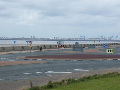
How we got there and back: We were staying in our caravan which was on a small farm site in North Wales, near St Asaph. This morning we drove to Neston where we parked on the water front, again for free! We walked up to Neston town centre where we caught a bus to Birkenhead, then another bus to Wallasey village. (We used our bus passes today, but we won’t be able to use them in Wales because they are for England only.) We walked down to the seafront to where we finished the last Walk two days ago.
At the end we came, exhausted, to our car. We had our tea and chocolate biscuits, then we drove back to the caravan in North Wales.
 We sat in a shelter and ate our pies before we began today’s Walk. The weather was much, much better than it was
two days ago (well, it could hardly be worse, could it?) and we looked forward
to a pleasant hike. The visibility was
so much better too, and, looking behind us, we could clearly see cranes etc at
Liverpool Docks which were only a couple of miles away at most. We watched a Stenaline ferry go out towards Belfast. In the far distance to the north we could see
an offshore windfarm.
We sat in a shelter and ate our pies before we began today’s Walk. The weather was much, much better than it was
two days ago (well, it could hardly be worse, could it?) and we looked forward
to a pleasant hike. The visibility was
so much better too, and, looking behind us, we could clearly see cranes etc at
Liverpool Docks which were only a couple of miles away at most. We watched a Stenaline ferry go out towards Belfast. In the far distance to the north we could see
an offshore windfarm.
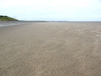
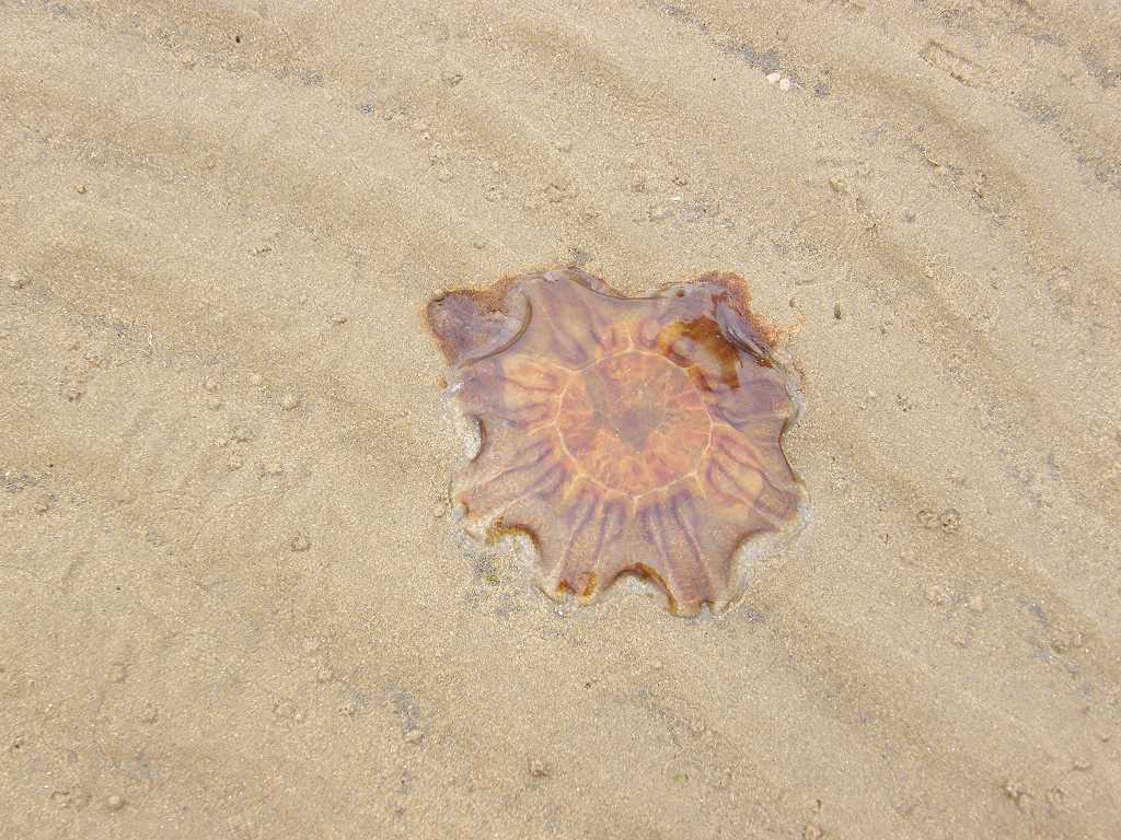
 The tide was out, so we went down on to the sand fairly soon. Such a pleasure to walk along a sandy beach
once again! There was a plethora of
razor shells, jellyfish and sea urchins on the sands, but we just crunched
through them — it was impossible to avoid them.
There were lots of cyclists along the prom, so we much preferred being
down on the sand.
The tide was out, so we went down on to the sand fairly soon. Such a pleasure to walk along a sandy beach
once again! There was a plethora of
razor shells, jellyfish and sea urchins on the sands, but we just crunched
through them — it was impossible to avoid them.
There were lots of cyclists along the prom, so we much preferred being
down on the sand.
Colin discovered his pad had leaked even though he’d only just sorted himself out in the public toilets at the start of the Walk. He has been referred to one of the top urologists in the country at the Queen Elizabeth Hospital in Birmingham, but his appointments are twelve weeks apart and they haven’t yet said what they are going to do about his problem. He can’t go on like this! It seems to be far worse when we go walking. I looked on the map for the next public conveniences, and saw that there was a leisure centre past the next two rock islands. So we trudged up to the prom after the second island, but only found a posh golf hotel. However, there was a pill-box on a corner, so Colin climbed over the wall and changed his pad hidden in the privacy of this Second World War artefact.

 Much more comfortable, we returned to the beach. The tide was now so far out it was over the
horizon. Looking back we couldn’t see
the river at all between us and the docks.
(The Mersey’s
gone! Who’s pinched it?)
Much more comfortable, we returned to the beach. The tide was now so far out it was over the
horizon. Looking back we couldn’t see
the river at all between us and the docks.
(The Mersey’s
gone! Who’s pinched it?)
 We saw some bait-diggers, and we passed three
lifeguards sitting in a kind of open shed — but there was no water in front of
them! (Perhaps they were there to rescue
idiots caught out by the incoming tide.)
The sand got a bit muddy and slippery, so we returned to the prom to
walk. I slipped on a stranded jellyfish
on the way up, it was difficult to avoid them.
We saw some bait-diggers, and we passed three
lifeguards sitting in a kind of open shed — but there was no water in front of
them! (Perhaps they were there to rescue
idiots caught out by the incoming tide.)
The sand got a bit muddy and slippery, so we returned to the prom to
walk. I slipped on a stranded jellyfish
on the way up, it was difficult to avoid them.

 We found a single bench up above a car park, with a disused lighthouse
behind. So we sat on it to eat our sarnies. We just sat there thinking, “This is very
pleasant!” It’s days like this when we
know why we’re doing this Trek. The
weather’s calm and pleasant, and it brings us to places we have never thought
of visiting before — like the Wirral. As
we got up to leave, a cycling couple stopped and we got chatting. They were staying in their motor caravan and
were cycling the Wirral Way
— which we were also following for most of today. They were very interested in our venture, and
cycled alongside us for quite some distance, chatting. It was nice.
We found a single bench up above a car park, with a disused lighthouse
behind. So we sat on it to eat our sarnies. We just sat there thinking, “This is very
pleasant!” It’s days like this when we
know why we’re doing this Trek. The
weather’s calm and pleasant, and it brings us to places we have never thought
of visiting before — like the Wirral. As
we got up to leave, a cycling couple stopped and we got chatting. They were staying in their motor caravan and
were cycling the Wirral Way
— which we were also following for most of today. They were very interested in our venture, and
cycled alongside us for quite some distance, chatting. It was nice.

 We continued on the concrete prom for a few miles towards Hoylake. A river ran alongside us along the top of the
beach, but as the tide was out there was very little water in it. Quite a few boats though, tipped sideways as
they were stranded on the sand. As we
entered Hoylake we passed a very pretty Victorian drinking fountain — the
Victorians certainly knew how to build practical things with style!
We continued on the concrete prom for a few miles towards Hoylake. A river ran alongside us along the top of the
beach, but as the tide was out there was very little water in it. Quite a few boats though, tipped sideways as
they were stranded on the sand. As we
entered Hoylake we passed a very pretty Victorian drinking fountain — the
Victorians certainly knew how to build practical things with style!

 Hoylake is a popular resort, and it was a nice sunny Saturday in June so
there were a lot of people about on the prom and the beach. We bought ice creams and sat by a model boat
lake to eat them, watching children sail their toy boats. It felt quaintly old-fashioned and rather comforting
in this modern digital age.
Hoylake is a popular resort, and it was a nice sunny Saturday in June so
there were a lot of people about on the prom and the beach. We bought ice creams and sat by a model boat
lake to eat them, watching children sail their toy boats. It felt quaintly old-fashioned and rather comforting
in this modern digital age.
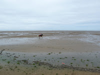 Further
along we watched families playing beach cricket, and a pony galloping along the
sands with a young rider on its back — the age-old things that people have
always loved doing at the seaside.
Further
along we watched families playing beach cricket, and a pony galloping along the
sands with a young rider on its back — the age-old things that people have
always loved doing at the seaside.
 We passed the lifeboat station with a fine sculpture outside. Full of energy, the statue is a memorial to a
number of lifeboatmen (mostly teenagers) who died in a tragedy back in
1810. A long time ago, but never
forgotten.
We passed the lifeboat station with a fine sculpture outside. Full of energy, the statue is a memorial to a
number of lifeboatmen (mostly teenagers) who died in a tragedy back in
1810. A long time ago, but never
forgotten.
 We came across another pirate ship built from beach rubbish, very like
the one we had passed in the wet at New
Brighton two days ago.
Branches were lined up on the grass, and people were still constructing
this one. Colin spoke to one of the
workers who told him they have to continually repair them because children play
on them — but that’s what they’re for so they don’t really mind. However, they did mind when vandals set fire
to the one in New Brighton. The local community responded by two hundred
of them turning up to build a new one!
We came across another pirate ship built from beach rubbish, very like
the one we had passed in the wet at New
Brighton two days ago.
Branches were lined up on the grass, and people were still constructing
this one. Colin spoke to one of the
workers who told him they have to continually repair them because children play
on them — but that’s what they’re for so they don’t really mind. However, they did mind when vandals set fire
to the one in New Brighton. The local community responded by two hundred
of them turning up to build a new one!
 We came to the end of the prom and took an “alternative beach route”
which was signposted. This led us back
on to the sand, but it was quite firm here.
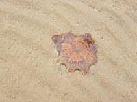
It got a bit slippy as we approached the corner, and we came across a
huge jellyfish there. We could see the
mountains of Wales
in the distance well before we got to the corner.
We came to the end of the prom and took an “alternative beach route”
which was signposted. This led us back
on to the sand, but it was quite firm here.
It got a bit slippy as we approached the corner, and we came across a
huge jellyfish there. We could see the
mountains of Wales
in the distance well before we got to the corner.
 As we rounded the corner I climbed over swirly rocks but Colin walked
round on the sand. He said it was OK,
not at all slippery, so I went down an old concrete lifeboat ramp and joined
him.
As we rounded the corner I climbed over swirly rocks but Colin walked
round on the sand. He said it was OK,
not at all slippery, so I went down an old concrete lifeboat ramp and joined
him.
 We turned south and decided to walk
to West Kirby on the beach because it was so
nice. We thought the tide should be in
by now, but there was still no water between us and an island on which there
seemed to be several houses — well, buildings anyway. There was no sign of a causeway, and we wondered
how the people got there across soft and slippery sand.
We turned south and decided to walk
to West Kirby on the beach because it was so
nice. We thought the tide should be in
by now, but there was still no water between us and an island on which there
seemed to be several houses — well, buildings anyway. There was no sign of a causeway, and we wondered
how the people got there across soft and slippery sand.
The beach began to get a bit muddy. We were now in the Dee Estuary, and there was marsh-grass growing everywhere. So we decided to go up to the beach top which we could see was busy with people. We felt it was a bit déjà-vu as we leapt from tuft to tuft of marsh-grass — we have definitely done this before! But we reached the path unscathed, and found there was a sandy track all the way into West Kirby.
 We sat on the first bench we came to and ate our apples. Colin declared he “couldn’t be bothered” to
walk round the huge marine lake which was in front of us. I thought that the path must be narrow and
possibly slippery (I was remembering Brighton Marina all those years ago!)
because it looked like that from a distance.
But whilst waiting (for ages and for the umpteenth time, poor Colin) for
him to sort himself out in the nearby public loo, I noticed that families with
small children, dogs and buggies were walking it. Surely it must be safe? So I changed my mind, and when Colin rejoined
me he was much more comfortable, and he agreed.
We sat on the first bench we came to and ate our apples. Colin declared he “couldn’t be bothered” to
walk round the huge marine lake which was in front of us. I thought that the path must be narrow and
possibly slippery (I was remembering Brighton Marina all those years ago!)
because it looked like that from a distance.
But whilst waiting (for ages and for the umpteenth time, poor Colin) for
him to sort himself out in the nearby public loo, I noticed that families with
small children, dogs and buggies were walking it. Surely it must be safe? So I changed my mind, and when Colin rejoined
me he was much more comfortable, and he agreed.

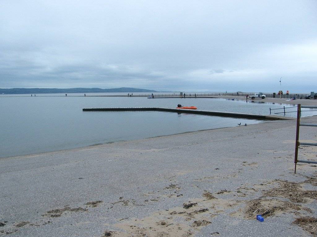
 We found it to be a wide safe tarmacked path after all. We were requested to keep off the rocks, no
cyclists and no dog fouling, but we had no difficulty complying with these
requests. It was a very pleasant walk,
and we watched novice wind-surfers practising on the lake as we marched by.
We found it to be a wide safe tarmacked path after all. We were requested to keep off the rocks, no
cyclists and no dog fouling, but we had no difficulty complying with these
requests. It was a very pleasant walk,
and we watched novice wind-surfers practising on the lake as we marched by.
At the further end we had to go inland a bit, then through a housing estate to a little country park. Colin insisted we sat on a bench overlooking the estuary to eat our chocolate, and it was rather pleasant. But we had no food left now — neither of us realised we were little more than halfway along today’s Walk.
 We turned on to the track of an old railway which we followed for miles! There were two parallel tracks, a wider one
for cyclists and a narrower one for walkers.
We followed the latter mostly, except where it was overgrown and
muddy. The only other walkers we came
across were a girl, her mother and their dog — but they were sauntering along
and we soon left them behind. Quite a
few cyclists were using the route, in both directions. We passed under a number of bridges, one was
badly cracked!
We turned on to the track of an old railway which we followed for miles! There were two parallel tracks, a wider one
for cyclists and a narrower one for walkers.
We followed the latter mostly, except where it was overgrown and
muddy. The only other walkers we came
across were a girl, her mother and their dog — but they were sauntering along
and we soon left them behind. Quite a
few cyclists were using the route, in both directions. We passed under a number of bridges, one was
badly cracked!

 Through one bridge Colin
stood on a station platform and pretended to wait for a train. Sorry,
you’ve got to walk! Sometimes we
could see the estuary away to our right, but it was not as far away as it
looked because there was an increasing amount of marsh-grass which looked like
fields.
Through one bridge Colin
stood on a station platform and pretended to wait for a train. Sorry,
you’ve got to walk! Sometimes we
could see the estuary away to our right, but it was not as far away as it
looked because there was an increasing amount of marsh-grass which looked like
fields.
 In Heswall the cycle track turned on to a residential road, then it
turned back on to the old railway at the next bridge. The following bridge was supported by a
colossal buttress — they’d obviously had a lot of trouble with it. We turned off the railway there, walked over
the supported bridge (it didn’t creak!) and down to the marsh. Concrete steps led us round a corner on to a
concrete-based footpath along the edge of the marsh. We were pleased that this footpath was in an
excellent state, much better than we had been expecting — we had been wondering,
because we have been let down so many times before, especially when it comes to
marshes. We even met a couple coming the
other way.
In Heswall the cycle track turned on to a residential road, then it
turned back on to the old railway at the next bridge. The following bridge was supported by a
colossal buttress — they’d obviously had a lot of trouble with it. We turned off the railway there, walked over
the supported bridge (it didn’t creak!) and down to the marsh. Concrete steps led us round a corner on to a
concrete-based footpath along the edge of the marsh. We were pleased that this footpath was in an
excellent state, much better than we had been expecting — we had been wondering,
because we have been let down so many times before, especially when it comes to
marshes. We even met a couple coming the
other way.
 We crossed a footbridge which marked the boundary between Merseyside and Cheshire, and the
footpath immediately improved dramatically.
It was now of wheelchair quality.
We passed a wooden seat on which were carved pictures of the numerous
birds to be found on the estuary just here.
A real work of Art!
We crossed a footbridge which marked the boundary between Merseyside and Cheshire, and the
footpath immediately improved dramatically.
It was now of wheelchair quality.
We passed a wooden seat on which were carved pictures of the numerous
birds to be found on the estuary just here.
A real work of Art!
 We came to a car park, and then on to a road which ran along the ‘sea’
front. It reminded us of Grange-over-Sands because there was a lovely prom with railings, but grass instead of a beach! A
notice told us that ships used to anchor in the main river channel a mere fifty
yards out from this spot. But this all
came to an end when the river was artificially forced to flow along the Welsh
shore. This place was also a bathing
resort until the 1930s.
We came to a car park, and then on to a road which ran along the ‘sea’
front. It reminded us of Grange-over-Sands because there was a lovely prom with railings, but grass instead of a beach! A
notice told us that ships used to anchor in the main river channel a mere fifty
yards out from this spot. But this all
came to an end when the river was artificially forced to flow along the Welsh
shore. This place was also a bathing
resort until the 1930s.
 We read a notice
telling us about the Parkgate Marsh project to reduce the mosquito population
in an environmentally friendly way. This
is by de-silting the main drainage gutter and creating deeper pools. I wonder if it is working.
We read a notice
telling us about the Parkgate Marsh project to reduce the mosquito population
in an environmentally friendly way. This
is by de-silting the main drainage gutter and creating deeper pools. I wonder if it is working.
 We walked past all the buildings to find our car parked at the end. We have been pleasantly surprised to discover that the Wirral is such a pleasant place to be. We really liked it.
That ended Walk no.328, we shall pick up Walk no.329 by the ‘sea’ front in Neston. It was eight o’clock, so the Walk had taken us eight and a half hours. We had our tea and chocolate biscuits, then we drove back to the caravan in North Wales.
Location: Wallasey to Neston.
Distance: 16 miles.
Total distance: 3378 miles.
Terrain: Concrete promenades. Firm beach sand. Cycle track on old railway. Flat.
Tide: Out, coming in this afternoon.
Rivers: None.
Ferries: None.
Piers: None.
Kissing gates: No.422 as we left West Kirby.
Pubs: None.
‘English Heritage’ properties: None.
Ferris wheels: None.
Diversions: None.
How we got there and back: We were staying in our caravan which was on a small farm site in North Wales, near St Asaph. This morning we drove to Neston where we parked on the water front, again for free! We walked up to Neston town centre where we caught a bus to Birkenhead, then another bus to Wallasey village. (We used our bus passes today, but we won’t be able to use them in Wales because they are for England only.) We walked down to the seafront to where we finished the last Walk two days ago.
At the end we came, exhausted, to our car. We had our tea and chocolate biscuits, then we drove back to the caravan in North Wales.


Colin discovered his pad had leaked even though he’d only just sorted himself out in the public toilets at the start of the Walk. He has been referred to one of the top urologists in the country at the Queen Elizabeth Hospital in Birmingham, but his appointments are twelve weeks apart and they haven’t yet said what they are going to do about his problem. He can’t go on like this! It seems to be far worse when we go walking. I looked on the map for the next public conveniences, and saw that there was a leisure centre past the next two rock islands. So we trudged up to the prom after the second island, but only found a posh golf hotel. However, there was a pill-box on a corner, so Colin climbed over the wall and changed his pad hidden in the privacy of this Second World War artefact.


The beach began to get a bit muddy. We were now in the Dee Estuary, and there was marsh-grass growing everywhere. So we decided to go up to the beach top which we could see was busy with people. We felt it was a bit déjà-vu as we leapt from tuft to tuft of marsh-grass — we have definitely done this before! But we reached the path unscathed, and found there was a sandy track all the way into West Kirby.


At the further end we had to go inland a bit, then through a housing estate to a little country park. Colin insisted we sat on a bench overlooking the estuary to eat our chocolate, and it was rather pleasant. But we had no food left now — neither of us realised we were little more than halfway along today’s Walk.


That ended Walk no.328, we shall pick up Walk no.329 by the ‘sea’ front in Neston. It was eight o’clock, so the Walk had taken us eight and a half hours. We had our tea and chocolate biscuits, then we drove back to the caravan in North Wales.

No comments:
Post a Comment