Weather: Grey.
Then drizzle. Brightening later.
Location: Neston to Flint.
Distance: 10 miles.
Total distance: 3388 miles.
Terrain: Marsh paths. New cycleways. Some roads. Spectacular bridge. Pavements. Flat.
Tide: Out.
Rivers: No.403, River Dee (Afon Dyfrdwy).
Ferries: None.
Piers: None.
Kissing gates: No.423 near Neston. Nos.424 & 425 near Flint. (All were on the marsh.)
Pubs: None. (We tried to visit the Royal Oak in Flint, but it was closed and up for sale!)
‘English Heritage / Cadw’ properties: No.1, Flint Castle. (Also closed to the public.)
Ferris wheels: None.
Diversions: None.
How we got there and back: We were staying in our caravan which was on a small farm site in North Wales, near St Asaph. This morning we drove to Flint where we parked next to the castle, again for free! We walked to the station and caught a train to Shotton where we climbed some steps to the high-level station. There we caught a train to Neston. It was about a mile to walk from the station to the waterfront where we finished the last Walk.
At the end we walked round Flint Castle to our car. We were pleased to finish this Walk mid-afternoon because brand new cycleways across the marshes had shortened our planned Walk by about four miles! We had our tea and chocolate biscuits, then drove back to the caravan near St Asaph.
 Outside the station at Neston is a sculpture of a huge foot. We thought it might be something to do with
the coal mining that went on here during the 18th, 19th
and early 20th centuries, but we didn’t really understand it. I expect it is deeply meaningful, but we are
simple souls………. We bought pasties, then
found a seat in town to eat them because they were still hot and delicious.
Outside the station at Neston is a sculpture of a huge foot. We thought it might be something to do with
the coal mining that went on here during the 18th, 19th
and early 20th centuries, but we didn’t really understand it. I expect it is deeply meaningful, but we are
simple souls………. We bought pasties, then
found a seat in town to eat them because they were still hot and delicious.
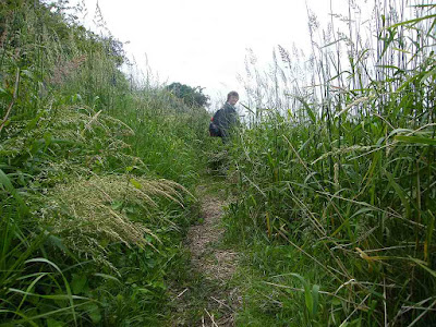
 We started the Walk proper on a marsh path which wasn’t marked on the
map. It wasn’t in bad condition,
especially for an unofficial path. There
were occasional muddy bits, but boards had been put down to help. As we progressed, the reeds got higher and
higher until they were taller than us!
At least they made good hiding places for the birds. At one place we came to a spout which was
continually pouring out water as if it was a tap.
We started the Walk proper on a marsh path which wasn’t marked on the
map. It wasn’t in bad condition,
especially for an unofficial path. There
were occasional muddy bits, but boards had been put down to help. As we progressed, the reeds got higher and
higher until they were taller than us!
At least they made good hiding places for the birds. At one place we came to a spout which was
continually pouring out water as if it was a tap.
 We soon came to the official path, and conditions improved. Again there were boardwalks down over the
muddiest bits. We saw a girl with a dog
out on the marshes. She caught us up and
talked non-stop. She told us about a new
footpath-cum-cycleway across the end of the ranges which had only been open a
couple of months. We got very excited
about this because we thought it would mean a short cut — in actual fact it
saved us more than four miles of walking, so we were very pleased.
We soon came to the official path, and conditions improved. Again there were boardwalks down over the
muddiest bits. We saw a girl with a dog
out on the marshes. She caught us up and
talked non-stop. She told us about a new
footpath-cum-cycleway across the end of the ranges which had only been open a
couple of months. We got very excited
about this because we thought it would mean a short cut — in actual fact it
saved us more than four miles of walking, so we were very pleased.
It started to drizzle, which turned into more intense rain. We hurried to the shelter of some trees and donned our wet-weather gear. We put the camera away because we didn’t want to get it ruined, then it was such a nuisance to get it out each time we saw something that we missed several photo-opportunities. We passed some houses and went on to a brand new cycleway which was marked as a mere footpath on our map. It is popular, we were passed by lots of cyclists over the next hour or so.
 We came to the point where we should have had
to go inland, but, as the girl had told us, there was a gate and a signpost
pointing to a brand new cycleway across the marshes. A notice explained it was not a right of way,
but the landowner had given permission for a cycleway to be put in and used.
We came to the point where we should have had
to go inland, but, as the girl had told us, there was a gate and a signpost
pointing to a brand new cycleway across the marshes. A notice explained it was not a right of way,
but the landowner had given permission for a cycleway to be put in and used.
 This was the biscuit! A brand new
wooden boardwalk to keep our feet dry and out of the mud when crossing the
marshes. It was not slippery despite
being wooden, and we were amused to see grass growing between the slats. It was great!
This was the biscuit! A brand new
wooden boardwalk to keep our feet dry and out of the mud when crossing the
marshes. It was not slippery despite
being wooden, and we were amused to see grass growing between the slats. It was great!
 We saw lots of ‘geology’ in a sandstone cliff we passed, we even saw an
unconformity. But it was raining and we
couldn’t be bothered to keep getting the camera out and keeping it dry. So we only took one picture. We could hear shooting on the other side when
we were passing a rifle range.
We saw lots of ‘geology’ in a sandstone cliff we passed, we even saw an
unconformity. But it was raining and we
couldn’t be bothered to keep getting the camera out and keeping it dry. So we only took one picture. We could hear shooting on the other side when
we were passing a rifle range.
The rain stopped momentarily, then it continued with intensity. Did it know we were almost in Wales? According to our map we crossed the border half way across the marshes, but there was no indication on the ground. But this was important — we were walking into our third country! So we fiddled with an umbrella and the camera to take a couple of pictures which I later merged on the computer at home.
 We were near the railway line. A
train went by — clackety clack. Don’t
they have welded rails around here? As
we neared a road bridge the rain stopped, so we sat on a wall to eat our
sandwiches. We noticed a number of wild
orchids nearby, and a very pretty snail.
(I don’t mind snails so long as they are not in my garden eating my vegetables!)
We were near the railway line. A
train went by — clackety clack. Don’t
they have welded rails around here? As
we neared a road bridge the rain stopped, so we sat on a wall to eat our
sandwiches. We noticed a number of wild
orchids nearby, and a very pretty snail.
(I don’t mind snails so long as they are not in my garden eating my vegetables!)
 We went under the road bridge, and then we had a choice of two ways —
either we continue south on the official path until we cross the River Dee on a
footbridge, or we turn west on a main road and cross a spectacular bridge which
we could see in the distance and which also happens to be the first bridging
point of the river. We chose the latter
route because it was one side of a triangle instead of two. We skirted round an industrial estate to save
a good bit of the road-walking. Then the
sun came out, so we swapped our kags for high-vis waistcoats to walk about a
mile alongside a very busy road.
We went under the road bridge, and then we had a choice of two ways —
either we continue south on the official path until we cross the River Dee on a
footbridge, or we turn west on a main road and cross a spectacular bridge which
we could see in the distance and which also happens to be the first bridging
point of the river. We chose the latter
route because it was one side of a triangle instead of two. We skirted round an industrial estate to save
a good bit of the road-walking. Then the
sun came out, so we swapped our kags for high-vis waistcoats to walk about a
mile alongside a very busy road.

 We were amazed at the plethora of wild flowers on waste land by the
industrial estate, especially poppies.
Wildflowers seem to have really gone to town this year, they are
fantastic! The cold Spring must have
suited them. We crossed the main road at
a roundabout and walked behind the Armco towards the bridge.
We were amazed at the plethora of wild flowers on waste land by the
industrial estate, especially poppies.
Wildflowers seem to have really gone to town this year, they are
fantastic! The cold Spring must have
suited them. We crossed the main road at
a roundabout and walked behind the Armco towards the bridge.
 Colin dived into the bushes to change his
pad, and while waiting for him I amused myself by taking macro-shots of wild
flowers. I couldn’t get over how
prolific they were, the variety, colour and scent! All the while vehicles were screaming past
next to us. We kept ourselves well in
from the road as we approached the bridge.
Colin dived into the bushes to change his
pad, and while waiting for him I amused myself by taking macro-shots of wild
flowers. I couldn’t get over how
prolific they were, the variety, colour and scent! All the while vehicles were screaming past
next to us. We kept ourselves well in
from the road as we approached the bridge.


On the bridge itself there was a walkway which kept us safe. It really is a spectacular bridge, with wires coming up from both sides to a single pillar. We crossed high over the River Dee — or Afon Dyfrdwy because now we were really in Wales! It looked very industrial on the other side. We passed a new power station, they seemed to be still working on it.

 Now the problem was — where to find this much-advertised Wales Coast Path
which was officially opened with much razzamatazz only last year? We walked down a slip road, and guessed our
way was along a cul-de-sac — it was certainly the safest route. We guessed we were now on the coast path, but
there was nothing about to tell us so.
We sat on a wall to eat our apples.
Now the problem was — where to find this much-advertised Wales Coast Path
which was officially opened with much razzamatazz only last year? We walked down a slip road, and guessed our
way was along a cul-de-sac — it was certainly the safest route. We guessed we were now on the coast path, but
there was nothing about to tell us so.
We sat on a wall to eat our apples.

 We walked on a few yards and came to a road which turned over the railway
into the power station. There was a
speed limit sign of 29mph — yes, we were definitely in a foreign country! But there we came across the first blue logo
of the Wales Coast
path, a logo we hoped to follow all the way round to the Severn Bridge
more than 800 miles further on.
We walked on a few yards and came to a road which turned over the railway
into the power station. There was a
speed limit sign of 29mph — yes, we were definitely in a foreign country! But there we came across the first blue logo
of the Wales Coast
path, a logo we hoped to follow all the way round to the Severn Bridge
more than 800 miles further on.
 There
were even studs in the pavement, so now we knew we were on the official Llwybr
Arfordir Cymru. But disappointment! Our way was to continue along the pavement
next to a busy main road all the way into Flint,
our first Welsh town. This is not what
we had envisaged when we got to the much-advertised Wales Coast Path. Things could only improve.
There
were even studs in the pavement, so now we knew we were on the official Llwybr
Arfordir Cymru. But disappointment! Our way was to continue along the pavement
next to a busy main road all the way into Flint,
our first Welsh town. This is not what
we had envisaged when we got to the much-advertised Wales Coast Path. Things could only improve.

 We passed a couple of interesting buildings, an old house and a
chapel. Also we noticed a number of
birds — starlings? — perching on telephone wires. We were well into Flint before we were able to turn away from
the constant traffic into the marshes.
We passed a couple of interesting buildings, an old house and a
chapel. Also we noticed a number of
birds — starlings? — perching on telephone wires. We were well into Flint before we were able to turn away from
the constant traffic into the marshes.
 There
we could see Neston, where we started today’s Walk, across the mudflats. A poem by Charles Kingsley on an information
board told us about the dangers of walking on the mud:
There
we could see Neston, where we started today’s Walk, across the mudflats. A poem by Charles Kingsley on an information
board told us about the dangers of walking on the mud:
 We thought we were following the official path after we entered the
marshes, but it got very squelchy and we came to a deep ditch which we couldn’t
cross. We had to backtrack (hate
doing that!) and eventually found our way back to the main path with boardwalks
and wooden bridges over the worst bits.
At least it wasn’t misty, and we didn’t encounter any “cruel foam”!
We thought we were following the official path after we entered the
marshes, but it got very squelchy and we came to a deep ditch which we couldn’t
cross. We had to backtrack (hate
doing that!) and eventually found our way back to the main path with boardwalks
and wooden bridges over the worst bits.
At least it wasn’t misty, and we didn’t encounter any “cruel foam”!

 Then the path became tarmacked — you could have pushed a wheelchair along
it. It was very nicely set out with
benches to rest on and artwork along the way as we approached Flint Castle.
Then the path became tarmacked — you could have pushed a wheelchair along
it. It was very nicely set out with
benches to rest on and artwork along the way as we approached Flint Castle.

 This was built in 1277 by Edward I, the first
in a series of castles built in his campaign to conquer Wales — his ‘Iron Ring’ of fortresses designed
to encircle North Wales and oppress the Welsh. It was in a strategic position — just one
day’s march from Chester from where supplies could be brought along the River
Dee, and there was a ford across to England at low tide. It was besieged by Welsh in 1282 & 1294,
both attacks were unsuccessful. In 1399,
Richard II of England was
held there by Henry Bolingbroke before returning to London.
In 1647 it was held by the Royalists, and finally captured by
Parliamentarians after three month siege.
The castle was ‘slighted’ (ie partially destroyed) by Cromwell. In the 19th century, the outer
bailey was used as the County
Jail.
This was built in 1277 by Edward I, the first
in a series of castles built in his campaign to conquer Wales — his ‘Iron Ring’ of fortresses designed
to encircle North Wales and oppress the Welsh. It was in a strategic position — just one
day’s march from Chester from where supplies could be brought along the River
Dee, and there was a ford across to England at low tide. It was besieged by Welsh in 1282 & 1294,
both attacks were unsuccessful. In 1399,
Richard II of England was
held there by Henry Bolingbroke before returning to London.
In 1647 it was held by the Royalists, and finally captured by
Parliamentarians after three month siege.
The castle was ‘slighted’ (ie partially destroyed) by Cromwell. In the 19th century, the outer
bailey was used as the County
Jail.
 We found we could get in the dry moat, but the inside of the castle was
completely closed with padlocked gates.
We felt it had a rather gloomy look, and is now too dangerous to
enter. Our car was in the car park
there.
We found we could get in the dry moat, but the inside of the castle was
completely closed with padlocked gates.
We felt it had a rather gloomy look, and is now too dangerous to
enter. Our car was in the car park
there.
That ended Walk no.329, we shall pick up Walk no.330 in the car park of Flint Castle. It was ten past four, much earlier than we had anticipated, and the Walk had taken us six hours twenty minutes. We had our tea and chocolate biscuits, then drove back to our caravan near St Asaph.
Location: Neston to Flint.
Distance: 10 miles.
Total distance: 3388 miles.
Terrain: Marsh paths. New cycleways. Some roads. Spectacular bridge. Pavements. Flat.
Tide: Out.
Rivers: No.403, River Dee (Afon Dyfrdwy).
Ferries: None.
Piers: None.
Kissing gates: No.423 near Neston. Nos.424 & 425 near Flint. (All were on the marsh.)
Pubs: None. (We tried to visit the Royal Oak in Flint, but it was closed and up for sale!)
‘English Heritage / Cadw’ properties: No.1, Flint Castle. (Also closed to the public.)
Ferris wheels: None.
Diversions: None.
How we got there and back: We were staying in our caravan which was on a small farm site in North Wales, near St Asaph. This morning we drove to Flint where we parked next to the castle, again for free! We walked to the station and caught a train to Shotton where we climbed some steps to the high-level station. There we caught a train to Neston. It was about a mile to walk from the station to the waterfront where we finished the last Walk.
At the end we walked round Flint Castle to our car. We were pleased to finish this Walk mid-afternoon because brand new cycleways across the marshes had shortened our planned Walk by about four miles! We had our tea and chocolate biscuits, then drove back to the caravan near St Asaph.
We have walked into Wales, our third country!


It started to drizzle, which turned into more intense rain. We hurried to the shelter of some trees and donned our wet-weather gear. We put the camera away because we didn’t want to get it ruined, then it was such a nuisance to get it out each time we saw something that we missed several photo-opportunities. We passed some houses and went on to a brand new cycleway which was marked as a mere footpath on our map. It is popular, we were passed by lots of cyclists over the next hour or so.


The rain stopped momentarily, then it continued with intensity. Did it know we were almost in Wales? According to our map we crossed the border half way across the marshes, but there was no indication on the ground. But this was important — we were walking into our third country! So we fiddled with an umbrella and the camera to take a couple of pictures which I later merged on the computer at home.
 |
| Crossing the border into Wales |


On the bridge itself there was a walkway which kept us safe. It really is a spectacular bridge, with wires coming up from both sides to a single pillar. We crossed high over the River Dee — or Afon Dyfrdwy because now we were really in Wales! It looked very industrial on the other side. We passed a new power station, they seemed to be still working on it.


The Sands of Dee
“O Mary, go and call
the cattle home,
And call the cattle
home,
And call the cattle
home
Across the sands of Dee”;
The western wind was
wild and dank with foam,
And all alone went she.
The western tide crept
up along the sand,
And o’er and o’er the
sand,
And round and round the
sand,
As far as eye could
see.
The rolling mist came
down and hid the land;
And never home came
she.
"Oh! Is it weed, or fish, or floating hair—
A tress of golden hair,
A drownèd maiden’s hair
Above the nets at sea?
Was never salmon yet
that shone so fair
Among the stakes on Dee.”
They rowed her in
across the rolling foam,
The cruel crawling
foam,
The cruel hungry foam,
To her grave beside the
sea.
But still the boatmen
hear her call the cattle home.
Across the sands of Dee.


That ended Walk no.329, we shall pick up Walk no.330 in the car park of Flint Castle. It was ten past four, much earlier than we had anticipated, and the Walk had taken us six hours twenty minutes. We had our tea and chocolate biscuits, then drove back to our caravan near St Asaph.

No comments:
Post a Comment