Weather: Quite a strong wind. Very warm in the sun. Cooler when cloudy. Dry.
Location: Glan-yr-afon to Moelfre.
Distance: 12 miles.
Total distance: 3482 miles.
Terrain: A lot of grassy paths across farmland, and ferny paths along cliff tops. Beach walking — some sandy and some stony. A few quiet lanes. Squidgy paths along the top of beach / marsh. Undulating at the beginning and end of the Walk, the middle bit was flat.
Tide: Coming in.
Rivers: No.413, Afon Nodwydd.
Ferries: None.
Piers: None.
Kissing gates: Nos.476 to 491. These were concentrated at the beginning and end of the Walk, none in the middle.
Pubs: The ‘Ship Inn’ at Red Wharf Bay. Colin drank Derby Brewing ‘Piggy in the Middle’ and Conway ‘Keneally’s Ale’ whereas I had a shandy again as it was a hot day.
‘Cadw’ properties: None.
Ferris wheels: None.
Diversions: No.74 which we ignored because a local had told us we could ‘get through’, which we did. (Most of the track had disappeared in a landslide three months ago.) No.75 which we were unable to ignore because security fences had been put up. Work was being carried out in an adjacent holiday park, and the official coastal public footpath had been fenced off with no notice of a diversionary route. Fortunately we had just met a couple of employees at the Camp, and they told us how to get round the blockage, through the Park and via the beach.
How we got there and back: We were staying in our caravan on a remote farm in the middle of Anglesey. This morning we drove to Moelfre where we parked in a large free car park near the bus stop. We caught a bus to Menai Bridge, then a second bus out to Glan-yr-afon. This second bus was a real white-knuckle ride as we tore along impossibly narrow lanes, twisting and turning up and down hills. Great fun!
At the end we finished the Walk in Moelfre very near the car park. We partook of tea and chocolate biscuits, then drove back to our caravan at Bodnolwyn Wen.
 We started today’s Walk at the road junction in the hamlet of
Glan-yr-Afon which is just a handful of houses.
Further along the lane we passed a Methodist chapel which seemed to be
in the middle of nowhere, yet it was still functional. Opposite the chapel was an old quarry site
which had obviously been cleared out recently — we wondered if it was a
potential building site. The wild
flowers were gorgeous — honeysuckle, orchids and suchlike — big showy flowers.
We started today’s Walk at the road junction in the hamlet of
Glan-yr-Afon which is just a handful of houses.
Further along the lane we passed a Methodist chapel which seemed to be
in the middle of nowhere, yet it was still functional. Opposite the chapel was an old quarry site
which had obviously been cleared out recently — we wondered if it was a
potential building site. The wild
flowers were gorgeous — honeysuckle, orchids and suchlike — big showy flowers.


 After about half a mile we turned off the lane to walk paths and tracks
across fields. We stopped to talk to a
man who was hanging bird feeders outside his isolated house. He was saying how once common birds are now
much in decline due to habitat loss, he had noticed the reduction in customers
for his feeders over the years. He also
told us that there was a land slippage a bit further on and the footpath was
closed. The diversion was back to the
road, but the notice telling walkers about it had been blown away. He advised us to ignore it because, “Anyone who
is agile can get past easily!” We
thanked him for the information, and walked on.
After about half a mile we turned off the lane to walk paths and tracks
across fields. We stopped to talk to a
man who was hanging bird feeders outside his isolated house. He was saying how once common birds are now
much in decline due to habitat loss, he had noticed the reduction in customers
for his feeders over the years. He also
told us that there was a land slippage a bit further on and the footpath was
closed. The diversion was back to the
road, but the notice telling walkers about it had been blown away. He advised us to ignore it because, “Anyone who
is agile can get past easily!” We
thanked him for the information, and walked on.
We skirted a farmyard, then saw the post from which the notice had disappeared. We ignored it and carried on. Further on we sat on a bank and ate our sandwiches — we had no pies today because there wasn’t enough time, when we were in Menai Bridge between buses, to go to the pie shop. Colin complained that he was cold, but he hadn’t brought his coat because the sun was shining when we left the caravan this morning — he’s always doing things like that. I told him to put his kag on, which he did.
 We crossed more fields, then turned into a gully between ferns. There we came across a sheltered seat with a
magnificent view, it would have been an ideal place to have stopped and eaten
our sandwiches. How we wished there had
been a prior notice warning us that this was coming up!
We crossed more fields, then turned into a gully between ferns. There we came across a sheltered seat with a
magnificent view, it would have been an ideal place to have stopped and eaten
our sandwiches. How we wished there had
been a prior notice warning us that this was coming up!
 Colin disappeared into the bushes to change
his pad, so I sat on the bench admiring the view and the colourful wild flowers
which were all around.
Colin disappeared into the bushes to change
his pad, so I sat on the bench admiring the view and the colourful wild flowers
which were all around.
The track took us steeply downhill from there, and we soon came to a gate with “Footpath Closed” notices and “Danger Keep Out”. The security fencing had been laid aside, so we ignored them all and carried on.
 Before
long we came to the landslip. Half the
width of the track had disappeared leaving a gaping hole — but it was fenced
off and there was plenty of room to get round behind it. We didn’t feel there was any danger for
walkers at all. Honestly, we are more in
danger on the average cliff path! We
looked over the edge, from the safe position behind the fence, and saw dead
vegetation all the way down where a torrent of water must have whooshed past
taking a big lump out of the track. It
would have been impossible to get a vehicle past the hole, and we did wonder if
there were any cars stuck at the cottage behind us. Perhaps the “Danger” notices were for them.
Before
long we came to the landslip. Half the
width of the track had disappeared leaving a gaping hole — but it was fenced
off and there was plenty of room to get round behind it. We didn’t feel there was any danger for
walkers at all. Honestly, we are more in
danger on the average cliff path! We
looked over the edge, from the safe position behind the fence, and saw dead
vegetation all the way down where a torrent of water must have whooshed past
taking a big lump out of the track. It
would have been impossible to get a vehicle past the hole, and we did wonder if
there were any cars stuck at the cottage behind us. Perhaps the “Danger” notices were for them.
 Looking back from a zigzag in the track further
down we could see a digger working on the lower end of the landslip. According to the man with the bird feeders,
it had all happened some months back. It
will be a lot of work to restore the track so it can take cars again.
Looking back from a zigzag in the track further
down we could see a digger working on the lower end of the landslip. According to the man with the bird feeders,
it had all happened some months back. It
will be a lot of work to restore the track so it can take cars again.
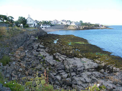
We came steeply down and emerged at the eastern end of Red Wharf Bay. The beach was rocky at first, so we went up on to the narrow road.
 At a passing place in this lane we past a “No
Shooting” notice, and there were more of them further along the bay. I don’t know what wildlife these ‘hunters’
take pot shots at, but I’m glad they’re not allowed to do it — for the
wildlife’s sake as well as our own safety.
At a passing place in this lane we past a “No
Shooting” notice, and there were more of them further along the bay. I don’t know what wildlife these ‘hunters’
take pot shots at, but I’m glad they’re not allowed to do it — for the
wildlife’s sake as well as our own safety.

 We met a couple from Liverpool and
stopped to chat. Then we went down on to
the now sandy beach and walked two kilometres along the high tide strand
line. We had to cross several little
rivers which were not on the map, but they were all shallow enough for us to
paddle through in our boots. We realised
that we were too far out on the wide expanse of beach — the tide was beginning
to come in by then — so we crossed some marshy ground to get back to the shore.
We met a couple from Liverpool and
stopped to chat. Then we went down on to
the now sandy beach and walked two kilometres along the high tide strand
line. We had to cross several little
rivers which were not on the map, but they were all shallow enough for us to
paddle through in our boots. We realised
that we were too far out on the wide expanse of beach — the tide was beginning
to come in by then — so we crossed some marshy ground to get back to the shore.
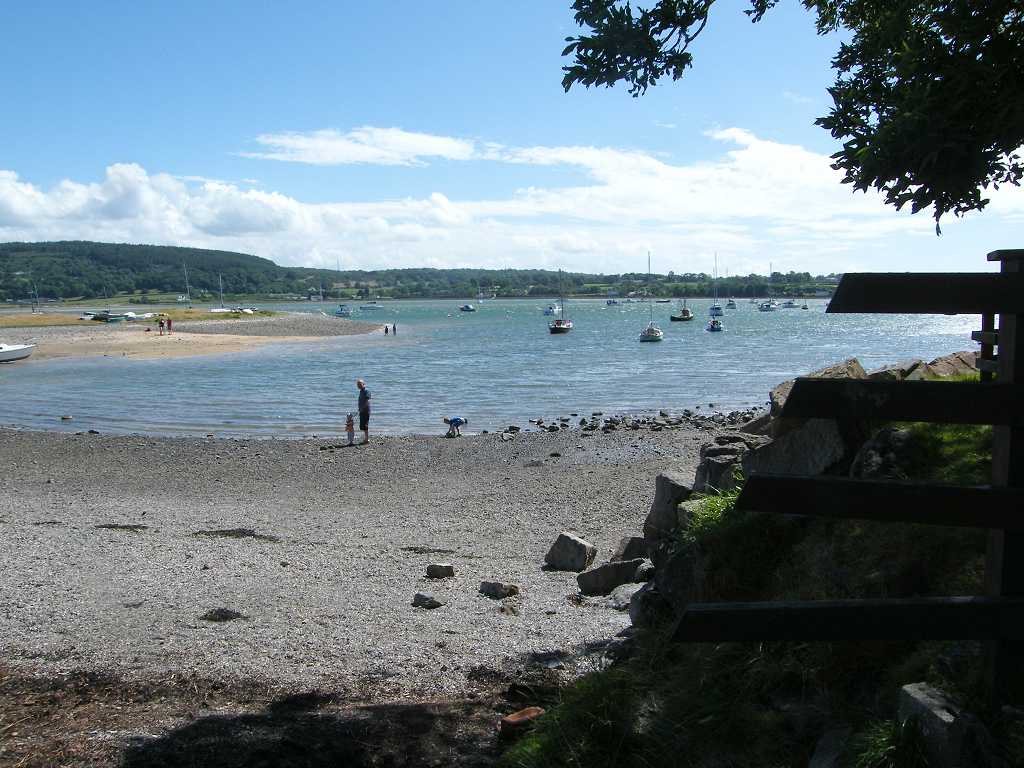
We were hailed by a couple who had emerged from a lane. They wanted to look at our OS map because they were thinking of cutting across the sand directly to the pub. Looking ahead, it did look as if this was possible. We told them that we had originally thought of doing just that, but there was a river in the way which we couldn’t see from beach level. They obviously didn’t quite believe us though we showed them the river clearly marked on the map. They said they’d go away and have another think!
 We sat on rocks near a collapsed building to eat our apples. Far in the distance we could see another
couple way out on the beach who had obviously thought they could cut across to
the pub. But they had reached the river
and were walking up and down looking for a crossing point. In the end they had to come inland to cross
the river on the road bridge, like the rest of us!
We sat on rocks near a collapsed building to eat our apples. Far in the distance we could see another
couple way out on the beach who had obviously thought they could cut across to
the pub. But they had reached the river
and were walking up and down looking for a crossing point. In the end they had to come inland to cross
the river on the road bridge, like the rest of us!

 There were lots of marshes now, it was a bit like Grange-over-Sands. We were glad we were on the clearly marked beach
track even though this was a bit squidgy in places. We came to the river at last, and had to go
on to the road to cross it — but at least this was no major diversion from our
path.
There were lots of marshes now, it was a bit like Grange-over-Sands. We were glad we were on the clearly marked beach
track even though this was a bit squidgy in places. We came to the river at last, and had to go
on to the road to cross it — but at least this was no major diversion from our
path.
 The tide was only half in, so we decided to continue on the marsh path. This was especially squidgy as we rounded a
corner to head northwards. We came to
where the official path went slightly inland through woods, but we decided to
remain on the top of the beach until we reached the pub because it was still a
good path. (Whilst sitting in the pub
garden supping our drinks, this path got covered by the tide.)
The tide was only half in, so we decided to continue on the marsh path. This was especially squidgy as we rounded a
corner to head northwards. We came to
where the official path went slightly inland through woods, but we decided to
remain on the top of the beach until we reached the pub because it was still a
good path. (Whilst sitting in the pub
garden supping our drinks, this path got covered by the tide.)
 The pub was very crowded and we found the beer to be good but
expensive. We sat on a seat outside in
the shade where we had a lovely view across the beach and the bay. Trouble was, we also had ‘lovely’ views of
too many “builder’s bums” in the vicinity!
It seems to be the fashion these days to hang your trousers below your
hips showing off your bum crease. Some
of the obese young men (this fashion is especially prevalent amongst such gross
creatures) were almost ‘mooning’ when they bent over! I don’t know how some of them manage to keep
their trousers from falling down — and they look horrible!! Yuk!
There were loads of FAT people on that beach — No! Don’t go down that road again! — but it is
sad to see so many fat children about.
They are all overloading the NHS who are finding it difficult to cope.
The pub was very crowded and we found the beer to be good but
expensive. We sat on a seat outside in
the shade where we had a lovely view across the beach and the bay. Trouble was, we also had ‘lovely’ views of
too many “builder’s bums” in the vicinity!
It seems to be the fashion these days to hang your trousers below your
hips showing off your bum crease. Some
of the obese young men (this fashion is especially prevalent amongst such gross
creatures) were almost ‘mooning’ when they bent over! I don’t know how some of them manage to keep
their trousers from falling down — and they look horrible!! Yuk!
There were loads of FAT people on that beach — No! Don’t go down that road again! — but it is
sad to see so many fat children about.
They are all overloading the NHS who are finding it difficult to cope.
 When we visited Red
Wharf Bay
on a Geology field course two years later (yes, it has taken me more than that
long to write up this Walk!) we were taken further up the beach from that point
to look at some geological wonders. But
we didn’t know about them today, and the tide was right in so we had to follow
the official path which led part-way up the low cliffs. We moved on towards caravan sites — the path
went behind them because they were Strictly
Private. We came to a fork in the
path where there was just a bare post, no signage. I thought we went uphill, and Colin was
convinced we went down. Just as we were
deliberating, a couple came along wearing the uniform of one of the Strictly Private caravan sites. They said, “Don’t go up there, it’s only a
field!” (So Colin had been right, I do
concede!) They led us along the lower
path saying, “This is the Coastal Path!”
But we quickly came to a barrier with a “Public Footpath Closed”
notice. Some workmen were lopping trees
adjacent to the path, and they had blocked it off without showing any diversion
route. But our uniformed guides were
very helpful. They took us into their Strictly Private holiday camp where they
showed us a path leading to a beach.
They told us that there was a sign further along the beach directing us
back into the woods on to the continuation of the path. Thank you to our helpful guides!
When we visited Red
Wharf Bay
on a Geology field course two years later (yes, it has taken me more than that
long to write up this Walk!) we were taken further up the beach from that point
to look at some geological wonders. But
we didn’t know about them today, and the tide was right in so we had to follow
the official path which led part-way up the low cliffs. We moved on towards caravan sites — the path
went behind them because they were Strictly
Private. We came to a fork in the
path where there was just a bare post, no signage. I thought we went uphill, and Colin was
convinced we went down. Just as we were
deliberating, a couple came along wearing the uniform of one of the Strictly Private caravan sites. They said, “Don’t go up there, it’s only a
field!” (So Colin had been right, I do
concede!) They led us along the lower
path saying, “This is the Coastal Path!”
But we quickly came to a barrier with a “Public Footpath Closed”
notice. Some workmen were lopping trees
adjacent to the path, and they had blocked it off without showing any diversion
route. But our uniformed guides were
very helpful. They took us into their Strictly Private holiday camp where they
showed us a path leading to a beach.
They told us that there was a sign further along the beach directing us
back into the woods on to the continuation of the path. Thank you to our helpful guides!

 It was a small sheltered beach, and lovely and sandy. It was being enjoyed by hundreds of
holidaymakers, a good half of them morbidly obese — No! Don’t keep going on about
it! But I can’t help it when they
unashamedly display acres of flesh for all to see!
It was a small sheltered beach, and lovely and sandy. It was being enjoyed by hundreds of
holidaymakers, a good half of them morbidly obese — No! Don’t keep going on about
it! But I can’t help it when they
unashamedly display acres of flesh for all to see!
We followed a pleasant path through woods which took us to Benllech, where we persuaded ourselves we deserved an ice cream each. I fancied Thornton’s chocolate caramel, but Colin went over the road where he bought a double cornet with free topping. We sat on a bench in the shade to consume these delicacies.
 Benllech has a small
but sandy beach. We sat there and
watched most of the crowds packing up for the day, taking their tired and
whining children with them. Too many of
them were obese — see! There I go again! But I’m proud that I have managed to lose one
and a half stone, that’s 12% of my body weight, since Christmas through careful
eating and exercise. I feel fantastic
because of it! And I still eat all the
foods I like, just not so much of them.
Benllech has a small
but sandy beach. We sat there and
watched most of the crowds packing up for the day, taking their tired and
whining children with them. Too many of
them were obese — see! There I go again! But I’m proud that I have managed to lose one
and a half stone, that’s 12% of my body weight, since Christmas through careful
eating and exercise. I feel fantastic
because of it! And I still eat all the
foods I like, just not so much of them.

 We continued northwards, and were soon on the coast path again. But this section was very narrow and
overgrown. We met several groups of
walkers to start with, but as we got further away from Benllech we were once
more on our own.
We continued northwards, and were soon on the coast path again. But this section was very narrow and
overgrown. We met several groups of
walkers to start with, but as we got further away from Benllech we were once
more on our own.
 It was very up-and-down,
lots of steps and boardwalks. We passed
a number of seats, but there was no view from any of them because of bushes and
trees which needed cutting back. We felt
this section of the Coast Path was in need of urgent TLC!
It was very up-and-down,
lots of steps and boardwalks. We passed
a number of seats, but there was no view from any of them because of bushes and
trees which needed cutting back. We felt
this section of the Coast Path was in need of urgent TLC!
 We battled our way through until we came to a headland where the grass
was mown! There was a ruined building in the middle of
the headland, and notices insisting we kept to the footpath round the edge and
not take a short cut through an estate of ghastly holiday homes. We came to a seat on the north-west side of
the headland where we could see our way ahead, so we sat on it to eat our
chocolate.
We battled our way through until we came to a headland where the grass
was mown! There was a ruined building in the middle of
the headland, and notices insisting we kept to the footpath round the edge and
not take a short cut through an estate of ghastly holiday homes. We came to a seat on the north-west side of
the headland where we could see our way ahead, so we sat on it to eat our
chocolate.
We continued down to the beach, then up over fields to a car park where there was a toilet block still open — bliss! I found someone’s handbag on the back of one of the basins. I left it there because I didn’t know what to do with it otherwise. I didn’t even look inside to see if there was a name. There were hardly any cars left in the car park. I just hoped the owner would remember where she had left it and come back for it.
 Leaving the car park, we couldn’t see any sign for the continuation of
the Coast Path. We deduced it was
through an unmarked rusty gate, and this proved to be correct. We had a few more fields to cross and then we
reached Moelfre, finding ourselves very near the car park where we had left the
car this morning.
Leaving the car park, we couldn’t see any sign for the continuation of
the Coast Path. We deduced it was
through an unmarked rusty gate, and this proved to be correct. We had a few more fields to cross and then we
reached Moelfre, finding ourselves very near the car park where we had left the
car this morning.
 That ended Walk no.337, we shall pick up Walk no.338 in Moelfre, near the
car park. It was quarter past seven, so
the Walk had taken us eight hours fifty-five minutes. We partook of tea and chocolate biscuits,
then drove back to our caravan at Bodnolwyn Wen.
That ended Walk no.337, we shall pick up Walk no.338 in Moelfre, near the
car park. It was quarter past seven, so
the Walk had taken us eight hours fifty-five minutes. We partook of tea and chocolate biscuits,
then drove back to our caravan at Bodnolwyn Wen.
Location: Glan-yr-afon to Moelfre.
Distance: 12 miles.
Total distance: 3482 miles.
Terrain: A lot of grassy paths across farmland, and ferny paths along cliff tops. Beach walking — some sandy and some stony. A few quiet lanes. Squidgy paths along the top of beach / marsh. Undulating at the beginning and end of the Walk, the middle bit was flat.
Tide: Coming in.
Rivers: No.413, Afon Nodwydd.
Ferries: None.
Piers: None.
Kissing gates: Nos.476 to 491. These were concentrated at the beginning and end of the Walk, none in the middle.
Pubs: The ‘Ship Inn’ at Red Wharf Bay. Colin drank Derby Brewing ‘Piggy in the Middle’ and Conway ‘Keneally’s Ale’ whereas I had a shandy again as it was a hot day.
‘Cadw’ properties: None.
Ferris wheels: None.
Diversions: No.74 which we ignored because a local had told us we could ‘get through’, which we did. (Most of the track had disappeared in a landslide three months ago.) No.75 which we were unable to ignore because security fences had been put up. Work was being carried out in an adjacent holiday park, and the official coastal public footpath had been fenced off with no notice of a diversionary route. Fortunately we had just met a couple of employees at the Camp, and they told us how to get round the blockage, through the Park and via the beach.
How we got there and back: We were staying in our caravan on a remote farm in the middle of Anglesey. This morning we drove to Moelfre where we parked in a large free car park near the bus stop. We caught a bus to Menai Bridge, then a second bus out to Glan-yr-afon. This second bus was a real white-knuckle ride as we tore along impossibly narrow lanes, twisting and turning up and down hills. Great fun!
At the end we finished the Walk in Moelfre very near the car park. We partook of tea and chocolate biscuits, then drove back to our caravan at Bodnolwyn Wen.


We skirted a farmyard, then saw the post from which the notice had disappeared. We ignored it and carried on. Further on we sat on a bank and ate our sandwiches — we had no pies today because there wasn’t enough time, when we were in Menai Bridge between buses, to go to the pie shop. Colin complained that he was cold, but he hadn’t brought his coat because the sun was shining when we left the caravan this morning — he’s always doing things like that. I told him to put his kag on, which he did.


The track took us steeply downhill from there, and we soon came to a gate with “Footpath Closed” notices and “Danger Keep Out”. The security fencing had been laid aside, so we ignored them all and carried on.


We came steeply down and emerged at the eastern end of Red Wharf Bay. The beach was rocky at first, so we went up on to the narrow road.


We were hailed by a couple who had emerged from a lane. They wanted to look at our OS map because they were thinking of cutting across the sand directly to the pub. Looking ahead, it did look as if this was possible. We told them that we had originally thought of doing just that, but there was a river in the way which we couldn’t see from beach level. They obviously didn’t quite believe us though we showed them the river clearly marked on the map. They said they’d go away and have another think!


We followed a pleasant path through woods which took us to Benllech, where we persuaded ourselves we deserved an ice cream each. I fancied Thornton’s chocolate caramel, but Colin went over the road where he bought a double cornet with free topping. We sat on a bench in the shade to consume these delicacies.


We continued down to the beach, then up over fields to a car park where there was a toilet block still open — bliss! I found someone’s handbag on the back of one of the basins. I left it there because I didn’t know what to do with it otherwise. I didn’t even look inside to see if there was a name. There were hardly any cars left in the car park. I just hoped the owner would remember where she had left it and come back for it.


No comments:
Post a Comment